Submitted:
04 December 2018
Posted:
05 December 2018
You are already at the latest version
Abstract
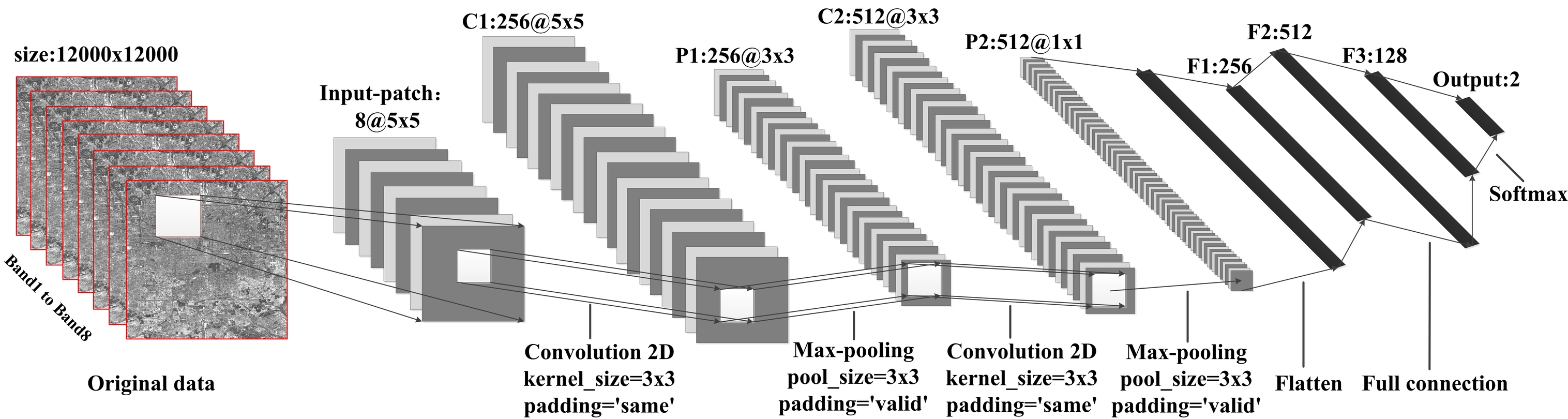
Detailed built-up area information is valuable for mapping complex urban environments. Although a large number of classification algorithms about built-up areas have been developed, they are rarely tested from the perspective of feature engineering and feature learning. Therefore we launched a unique investigation to provide a full test of the OLI imagery for 15-m resolution built-up area classification in 2015, in Beijing, China. Training a classifier requires many sample points, and we propose a method based on the ESA's 38-meter global built-up area data of 2014, Open Street Map and MOD13Q1-NDVI to achieve rapid and automatic generation of a large number of sample points. Our aim is to examine the influence of a single pixel and image patch under traditional feature engineering and modern feature learning strategies. In feature engineering, we consider spectra, shape and texture as the input features, and SVM, random forest (RF) and AdaBoost as the classification algorithms. In feature learning, the convolution neural network (CNN) is used as the classification algorithm. In total, 26 built-up land cover maps were produced. Experimental results show that: (1) the approaches based on feature learning are generally better than those based on feature engineering in terms of classification accuracy, and the performance of ensemble classifiers e.g., RF, is comparable to that of CNN. Two dimensional CNN and the 7 neighborhood RF have the highest classification accuracy of nearly 91%. (2) Overall, the classification effect and accuracy based on image patches are better than those based on single pixels. The features that can highlight the information of the target category (for example, PanTex and EMBI) can help improve classification accuracy.
Keywords:
built-up area
; classification
; Landsat 8- OLI
; feature engineering
; feature learning
; CNN
; accuracy evaluation
Copyright: This open access article is published under a Creative Commons CC BY 4.0 license, which permit the free download, distribution, and reuse, provided that the author and preprint are cited in any reuse.


