

Submitted:
10 October 2026
Posted:
12 October 2026
You are already at the latest version
Abstract
A large earthquake is still considered to be a natural catastrophic event causes immeasurably great material damage and also takes the lives of thousands of people. This is why reducing the earthquake occurrence risk is a critical issue, and researches in this area are of crucial importance for all seismically active countries. One of the most important achievements of seismology in recent decades is related to the study of earthquake initiation. Namely, natural and man-made impacts on seismicity have been considered. The attention is focused on experimental data that testifies to the existence of actively influencing the seismogenic environment with electrical impulses in order to smoothly relieve accumulated tectonic stresses by initiating earthquakes in the Earth's crust. Because at the moment of occurrence of an earthquake approaches, the focal zone becomes increasingly sensitive to external influences, it is clear that the problem of intentional initiation of earthquakes by explosion is closely connected with the problem of earthquake prediction. This article presents a completely new perspective on the possibilities of the earthquakes occurrence risk reduction and artificial release of accumulated tectonic stress in the earthquake preparation zone, based on the latest research on the possibilities of hourly earthquake prediction.
Keywords:
earthquake
; prediction
; tectonic stress
1. Introduction
“Results in nonlinear dynamics are consistent with the idea that earthquakes are inherently (or actually) unpredictable because of the highly sensitive nonlinear dependence on initial conditions”-
wrote the famous scientist R.J. Geller in 1997 [1].
“This pessimism has its reasons, as the simple traditional seismological approach is ineffective for this purpose. This situation can only be changed through interdisciplinary scientific research," was the opinion of Japanese scientists in 2009 regarding short-term earthquake prediction [2]:
“Earthquake prediction is the Saint Graal of seismology, but the study of possible earthquake precursors should be better regarded in the framework of fundamental geophysics more than in trying to guess the Future” - this is the view of famous American scientists a few years ago regarding earthquake prediction [3].
This pessimism regarding earthquake prediction is explained by the fact that, despite significant expenditures and laboratory, ground-based, and satellite studies conducted in almost all seismically active countries of the world to discover diagnostic precursors to earthquakes, reliable results have not yet been observed.
However, amidst the scientific debate, modern ground-based and satellite observation methods during the preparation of earthquakes in seismogenic zones reveal anomalous changes in various geophysical fields that accompany the process of earthquake preparation and manifest themselves several months, weeks, or days before earthquakes. This gives reason to believe that among them there must necessarily exist a geophysical field, the anomalous changes of which accurately describe the geological processes of fault formation at the earthquake's focus.
Therefore, this field can be considered a diagnostic precursor. In such a case, it is no longer in dispute that it is possible to predict earthquakes based on it. This will allow scientists to address a number of the earthquake related issues, including reducing the occurrence risk of destructive earthquakes, enabling artificial reduction of tectonic stress, and more.
The fact that an exceptionally high sensitivity of the processes occurring in the focus of an approaching earthquake to external natural and artificial influences was discovered allowed us to think about such problems.
Discussion
2.1. Opinions on the Possibility of Tectonic Tension Reduction
At the end of the last century, a well-known Russian scientist, corresponding member of the Russian Academy, doctor of phys.- math. sciences, the author of the definition of tectonic weapons Aleksey V. Nikolayev, published an article "On the possibility of artificial discharge of tectonic stress using seismic and electrical influences" [4].
In the work had been considered both "Seismicity initiated by natural processes "(Earth’s tide, changes in the speed of Earth’s rotation, weather phenomena, large earthquakes), also "Seismicity initiated by anthropogenic impacts” (construction of huge dams and reservoirs, oil and gas production, underground nuclear tests, impact on the earth's crust with powerful electrical impulses,
Since the seismic reaction of the medium to the joint effect of several initiating natural and anthropogenic processes deserves special attention, below we present excerpts from works published in this direction.
According to Nikolaev: “Certain action affects the focus of the earthquakes that would inevitably occur even without external intervention, but the process of their preparation would be slightly longer", and the magnitude would be slightly greater. They influence seismicity, reduce seismic hazard, and alter the energy balance between large and small earthquakes in favor of small ones. But there exist factors that cause earthquakes that would never have happened or would have happened with a long delay. These are the excavation of minerals, the construction of huge reservoirs, pumping of liquid industrial waste into the ground.These exposures increase the seismic hazard and, due to the increase in the scale of engineering activities, industrial and civil construction, rapidly increase the seismic risk”.
Thanks to the exceptionally high sensitivity of seismic processes, the question arises about the possible application of artificial impact on the earth's crust with the aim of artificially controlled discharge of destructive earthquakes' tectonic stresses, initiating earthquakes at prior specific time intervals to reduce seismic hazard and risk.
Reducing the seismic hazard should be carried out not only by reducing the magnitude of destructive earthquakes using special impacts on the earth's crust, but also by reducing the hazards of destructive anthropogenic earthquakes occurring. This can be achieved by choosing optimal methods of anthropogenic influence, if possible, coordinated with natural influences.
Controlling the process of discharging tectonic stresses, artificially initiating the growth of weak and moderate seismicity, accelerating the preparation process of a strong earthquake, and a result, reducing its magnitude should be considered possible [4].
It is noteworthy that the author pays special attention to the powerful electrical impulses among the various methods of impact on the Earth's crust. The reaction of seismicity to powerful electrical impulses is the most surprising result obtained in recent years. This refers to the work of N.T. Tarasov: “Changing seismicity by electrical impulses” [4,8].
According to A. V. Nikolayev, the gist is that the initiating electric field is very weak. It was found that a powerful dipole source (generator) with a distance between electrodes of 1.5 km, emitting a 5-second pulse into the ground with a total energy of 10 MJ, significantly excites seismic activity within a radius of up to 50 km (the region of Central Tajikistan). The number of earthquakes that occurred before and after of electric signals injection, was 15 and 28.
Nikolayev was writing in 1999 that a much more powerful source (100 MJ) is installed and operates in Kyrgyzstan.
Its initiating effect on the seismicity of weak and moderate earthquakes (M = 1.5...4) is distinctly manifest at a distance of up to 500 km [4].
Calculations show that the additional seismic energy released as a result of the initiating action of electrical impulses is 5-6 orders of magnitude greater than the energy acting on the focal zones of earthquakes. The seismic response to electrical impact is observed during the first 2-3 weeks after the "electroshock", while mostly shallow (focal depth up to 5 km) earthquakes are initiated. Low-magnitude earthquakes (up to 1.5) and earthquakes with a magnitude, more than 3 respond most strongly to electrical influence [4,8]
Artificial discharge of tectonic energy can be implemented in two different ways. The first is the initiation of discharge in large areas by regular "processing" of these areas with powerful electrical and seismic sources, underground nuclear or chemical explosions. The second method is a purposeful impact on the focus of the incoming large earthquake. In addition, powerful pulsed electrical sources can be replaced by sources of relatively low power, but long-acting. However, the author noted that, despite the great attention paid to the study of induced seismicity in recent years, this problem remains insufficiently studied.To achieve this goal, it was necessary to "find a place where nature has already prepared catastrophic earthquake. In other words, it is necessary to solve the problem of earthquake prediction” [4].
To possess prognostic methods means to be able to foresee the impact of natural and anthropogenic influences on the formation of an earthquake focus.
This also means that earthquake prediction in combination with controlled anthropogenic impact will make it possible to influence the process of preparing the source, stimulate the discharge of tectonic stresses, reduce the magnitude of destructive earthquakes, and regulate the time of their occurrence.
As mentioned above, because the problem of intentional initiation of earthquakes is very closely related to the problem of earthquake prediction: at the first, it is necessary to identify the prepared focus, and then with the help of the impact, it will be possible substantially-up to several days (instead of weeks and months) – to reduce the time of occurrence of an earthquake [4].
2.2. The Diagnostic Precursor and Based on it the Earthquakes Short-Term Prediction
It should be emphasized that numerous anomalous natural phenomena observed before earthquakes, due to the interest in the problem of earthquakes, have been collected. All they are called earthquake precursors, but studies have shown that anomalous fields, observed in the seismogenic area during the earthquake preparation period, must be divided into three groups by their origination and their influence on incoming earthquakes. They are: earthquake triggering factors, earthquake indicators, and earthquake precursors, which can be defined as follows:
- Earthquake triggers (natural or man-made) are a physical field that exists independently of the earthquake preparation process. They can influence the period of preparation for an earthquake only at its final stage (for example, tides, changes in atmospheric pressure in some cases, mutual influence of earthquakes, a sharp change in the water level in reservoirs, underground nuclear tests, etc), that is, at the moment when tectonic stress reaches the limit of the solidity of the geological medium. At this time, they can affect the tectonic stress and correct the time of earthquake occurrence.
- An earthquake indicator is a physical field that undergoes abnormal changes during a certain period of the process of earthquake formation. The occurrence of seismic indicators is not caused by the direct process of formation of the main fault at the focus of an incoming earthquake. It is caused by perturbations of geophysical fields in seismogenic (mostly focal) areas. Therefore, “earthquake indicators” are those anomalous changes of geophysical fields caused by the side effects of the earthquake preparation process. They are useless for earthquake prediction because they cannot analytically describe the process of main fault formation.
- The main process of fault formation occurs as a result of the appearance and merging of cracks in the focus of an approaching earthquake. This process causes VLF/LF EM emissions and is reflected on the earth’s surface by anomalous changing characteristic parameter (or parameters) of this field. Such anomalous changes make it possible to simultaneously and with high accuracy predict the magnitude, time of occurrence, and epicenter of an incoming earthquake. It is the reason why VLF/LF EM emissions should be considered an earthquake precursor.
Our study confirmed that ELF/VLF electromagnetic radiation is responsible for short-term earthquake prediction [9,10,11].
Long-term observations have revealed special properties of ELF/VLF electromagnetic radiation that manifest themselves both during the preparation of an earthquake and during the earthquake itself. Specifically: EM emissions appear approximately several weeks before the earthquake, the radiation spectrum is characterized by the following sequence: MHz, kHz. EM emissions are accompanied by ULF radiation, electromagnetic radiation in the VLF/LF range becomes very weak or disappears completely (the so-called “silence”, which occurs during a certain period before an earthquake). This “silence” is followed by an earthquake [12].
A study of global scientific research allowed us to develop a model for the generation of electromagnetic radiation recorded before earthquakes, based on electrodynamics and the classical geological model of avalanche-like fault formation. This original model considers natural electromagnetic oscillations of local segments of the lithosphere as sources of electromagnetic radiation.
The formula adopted in this study for the first time allows us to analytically link the frequency of the observed electromagnetic radiation and the linear size of the emitting body (the length of the fault at the earthquake focus), and based on it, the magnitude of an impending earthquake can be easily calculated [9].
Our research has shown that the above-mentioned formula allows us not only to determine the stage of earthquake preparation, but also to track quantitative changes in the length at the source arisen the main fault. Research has clearly confirmed that electromagnetic radiation of a specific spectral range, recorded before earthquakes, is the only field that accurately describes the avalanche process of fault formation during the preparation period of an earthquake. In particular, it describes the processes of closing and opening of cracks of different sizes in the focal zone and their ordering in a certain direction, which ultimately leads to the formation of the main fault [9,10,11].
It should be emphasized that the very high accuracy of measuring electromagnetic radiation in the VLF/ULF ranges also makes it possible to determine the length of small cracks with high accuracy. For instance, before the L’Aquila catastrophic earthquake (6 April 2009), besides Ultra-low frequency and kHz electromagnetic anomalies, 41 MHz (ω1) and 54 MHz (ω2) radiation were also recorded [12,13]. According to our study, the corresponding length of the first emitting body (which radiates ω1 frequency) would be l1 = 0.007 km, and the corresponding length of the second emitting body (which emitted ω2 frequency) would be l2 = 0.006 km. This means that electromagnetic radiation can detect even the slightest changes in the length of micro cracks.
Since electromagnetic radiation existing before an earthquake at any stage of its preparation gives us information about even minor changes in the length of the main fault, this means that we can monitor the change in the magnitude of an incoming earthquake. However, we have to remember that there are limitations in terms of reaching high-frequency electromagnetic radiation to the earth’s surface.
As it is known, an earthquake preparation process goes according to the well-known avalanche-like unstable geological model of fault formation, which step by step describes the various sizes cracks originations and the main process of the fault length forming in the focus of an impending earthquake. Namely, at the first stage, chaotic formation of cracks occurs in the earthquake preparation zone, when, as a result of the interaction of cracks, the average density of ruptures reaches a certain critical value in the entire volume or a significant part of it. As a result of the interaction of cracks, an avalanche stage of a given earthquake preparation sets in. It means that the first stage of earthquake preparation goes over to the second stage. The involvement of an increasing number of inhibited cracks in this process leads to the unification of cracks of a higher rank (larger size), which is associated with a rapid and sharp redistribution of the local stress field. An increase in the number and size of cracks, like an avalanche-like growth, leads to a sharp increase in the rate of overall deformation, which causes a change in the integral physical characteristics of the medium. The increase in deformation is already accompanied by a drop in stress in the third stage. Unstable deformation is compressed into a narrow zone due to the heterogeneity of the properties of the medium, in which several relatively large cracks form. In this case, there is a general drop in average macro stresses over most of the volume. Due to this, the cracks stop developing and partially close. Сonsequently, the integral deformation rate of the total zone decreases at this instability third stage. The restoration of many integral characteristics of the medium takes place. The narrow zone of unstable deformation by an increased concentration of cracks is characterized and represents the surface of the main fault of the incoming earthquake. In fact, this process can be considered as the so-called main period of “silence”, which immediately begins after the end of the active stage of the avalanche process. The fault of the earthquake is formed by ripping apart the cofferdams (bridges, links between cracks). This process qualitatively is similar to the general process, and therefore, it must be preceded by short-term and smaller changes in the amplitude of the strain rate. It happens that the destruction of one of the cofferdams may not be enough to rip apart the entire main fault. Due to this, there can be several such short-term changes in the deformation rate. In this case, as a result, these oscillations must precede large foreshocks, and the final one must be a direct foreshock or the main shock itself [10,14].
It is obvious that if, in the case of VLF/LF EM emissions data monitoring, the corresponding records allow a quantitative description of the full cycle of preparation and occurrence of earthquakes according to the avalanche-like unstable geological model of fault formation, then this field is practically a diagnostic precursor of an earthquake.
Therefore, this model unambiguously explained the above-mentioned special properties of VLF/LF electromagnetic radiation existing before an earthquake [9].
Our studies have revealed that VLF/LF EM emissions are responsible for three-stage earthquake early warning and short-term earthquake prediction. In addition, recordings of electromagnetic radiation make it possible to determine the length of the fault at the earthquake source with an accuracy of not a kilometer, but a higher order at the final stage of the monitoring process. We found out that electromagnetic radiation of the order of kHz (23,830 kHz ≥ f ≥ 0.378 kHz) is significant for earthquakes with a magnitude of 1 ≤ M ≤ 9. The electromagnetic wave with this diapason is not absorbed by the earth. We can assume that all processes occurring at the source of an earthquake, from the initiation of micro cracks to the final formation of a fault, can be observed on the earth’s surface in almost parallel mode, if we take into account the speed of electromagnetic waves. This field is a diagnostic precursor because, besides the earthquake magnitude, it allows us to calculate the epicenter of an incoming earthquake and the expected time of its occurrence as well.
Most importantly, that based on the retrospective data of this diagnostic precursor, we were able to create a three-stage early warning and short-term prediction method for earthquakes [11].
Thus, based on the above studies and by using special, reasonably organized impacts on the earthquake focus, it is possible to carry out a controlled discharge of tectonic energy, and reduce seismic hazard [6,7,8].
This research was made possible by the fact that, according to our research, studying VLF/LF electromagnetic radiation allows us to determine the magnitude of an approaching earthquake approximately 50 days before it occurs. In addition, on the radiation channel of a given frequency is clearly shown the moment of onset and the developing character of the avalanche process of the earthquake preparation [9,11] which allows to select simple, easy implemented, environmentally safe, inexpensive method and handy time of impact for reducing of tectonic tension.
This refers to the possibility that the impact of the unloading method will not affect the entire area over which the tectonic anomaly extends, but only a specific, “live” fault. That is why we let ourselves return to this vital issue again. In our view, in order to prevent large earthquakes, the time has come, when the formulation of the problem of controlled discharge of accumulated tectonic stress in the earth's crust, becomes actual.
To carry out the above-mentioned works, it is initially necessary to assess the seismic risk for the given territory.
2.3. Regional Geological Study in Terms of the Earthquake Occurrence Risk Reduction Possibility
The work scheme presented by us is based on the possibility of short-term prediction of the incoming earthquake, and proceeds from the fact that we can already determine all necessary three characteristic parameters (magnitude, epicenter, time of occurrence) for incoming earthquake prediction with great precision at least several dozen days before the earthquake
[11]. It is obvious that the earthquake occurrence risk reduction should be based on today's existing seismic risk assessment method, as a baseline, of course. Since already having possibility to predict earthquake, we should use the opportunity to choose specific risk reduction conditions for the concrete incoming earthquake, taking into account the specific magnitude, the time of the earthquake occurring, the coordinates of the earthquake epicenter, and the given specific geological structure. In addition, besides the other parameters required for a seismic risk assessment that the existing methodology incorporates, the proposed study will allow us to determine the preferential direction of seismic energy radiation from an incoming earthquake focus.
One of the most important aspects of solving this problem is the ability to conduct electromagnetic measurements in the VLF/LF diapason, which can serve as a basis for prognostic earthquakes in the area under study.
Let us consider the example of Georgia.
Georgia, as a part of the Caucasus region, is located in the Alpine-Himalayan seismic zone, and the study of the earthquake problem is of vital significance for this country, too. High geodynamic activity of Georgia and adjacent areas of the Caucasus, expressed in both seismic and aseismic deformations is conditioned by the still-ongoing convergence of lithospheric plates and northward propagation of the Arabian plate at a rate of several mm/year. The post-collision sub-horizontal shortening of the Caucasus is estimated at hundreds of kilometers [18]. According to the instrumental data, starting from 1899, about 40 large earthquakes were recorded in the Caucasus. The rate of risks associated with earthquakes increases every year in Georgia due to the appearance of new complicated technological constructions: oil and gas pipelines, large dams, hydropower plants, and others.
The Caucasus region is located in the northernmost part of the Arabia-Eurasia collision zone (Figure 1A). Recent work about the Lesser Caucasus demonstrates that it is a double-wedge orogen formed by the ongoing collision between the Arabian and Eurasian plates (Figure 1B) [16,18,19,21,22,23,24]. If we have no idea about the deep structure of active zones and do not understand the nature of tectonic processes, then it is difficult to predict seismic hazard. The Lesser Caucasus is one of the best field laboratories to investigate active faults and compressive deformation.
The Georgian part of the Lesser Caucasus orogen (Figure 2) is represented by a pro-wedge. Here, we show a new structural model for the Georgian part of the Lesser Caucasus orogen by integrating field, boreholes, and seismic data (Figure 3 and Figure 4) [17,19,20,25] The structural cross-section A-AI reveals the presence of upper and lower structural complexes (Figure 3). The upper structural complex is represented by a shallow triangle zone which includes a north-vergent Armazi fault-propagation fold, north-vergent duplex, and south-vergent passive-backthrust at the mountain front. The lower structural complex is represented by a structural wedge and is made up of lower Cretaceous-Jurassic strata. Two north-vergent blind thrusts are developed above the structural wedge (Figure 3).
Dominant structural styles of the active compressional structures are related to multiple detachments and are represented by the Khrami basement thrust sheet, crustal-scale duplex, fault-related folds, triangle zones, passive-roof duplex, passive-roof thrust, and passive-back thrust (Figure 4). Pliocene-Quaternary lava flows are involved in the compressional deformation and are related to an out-of-thrust sequence of the Khrami basement thrust sheet. According to the structural cross-section (Figure 4), the horizontal displacement of the basement thrust sheet is about 20km [17].
Apatite fission-track data from the central part of the Lesser Caucasus orogen record two successive stages of compressional exhumation in the Neogene: (1) Early to Middle Miocene, and (2) Middle Miocene to present [22] Syn-orogenic (Miocene-Pliocene) sediments within the Kura foreland basin preserve important information for understanding the tectonic process of convergence between the Lesser Caucasus and the Greater Caucasus. In the Kura foreland basin, the transition from marine to continental deposition occurred between the late Miocene and Pleistocene. During the Upper Miocene and Pliocene, the Lesser Caucasus and the Greater Caucasus were the source area of continental, coarsening upwards deposits in the Kura foreland basin [27]. The geometry and unconformity surfaces of the Miocene growth strata in the study area are observed in outcrops, as well as in seismic profiles [25]. Fission track data and comparison of growth strata ages enable us to suppose that the formation of the Lesser Caucasus frontal part took place during the middle-upper Miocene. Later in the Pliocene, deformation of the frontal part of the western Kura foreland basin, as well as convergence and collision of two orogens, occurred [24,25].
Based on published information about historical and recent earthquake data [28] [fission-track data from the Lesser Caucasus [24] age of syn-tectonic units from the frontal part of the Lesser Caucasus orogen and Kura foreland basin [25] indicate that compressive deformation within the Lesser Caucasus and the Greater Caucasus convergence zone started in the Middle-Upper Miocene and continues today. Near the Lesser Caucasus and the Greater Caucasus convergence zone is located Tbilisi city (Figure 1), and north-and-south-vergent thrusts of this zone represent significant hazards.
Georgia is cited as an example of a small and geologically complex region. It demonstrates that in such small and geologically complex countries and regions, carrying out the aforementioned work to mitigate risks associated with accumulated tectonic energy requires different conditions for high-precision earthquake forecasting. The VLF/LF electromagnetic emission networks currently operating in various countries around the world are distributed over large areas. The networks employed to detect this radiation consist of stationary transmitters and receivers., For example, the European network (INFREP)-ის receivers are being into operation in different European countries. However, there are reported cases of existing networks being unable to detect any electromagnetic radiation prior to large earthquakes [29,30]. The fact that earthquakes occur in areas where tectonic stress is accumulated and that the same areas are also responsible for the generation of the faults that start the electromagnetic emissions a few months before the earthquake, suggests the need a network of mobile receivers of VLF/LF electromagnetic emissions, without transmitters [31]. In such a case, by monitoring the incoming earthquake magnitude, it is also possible to estimate the approximate changes of fault lengths in the focus of an incoming earthquake. Therefore, the “sensitive area’ of VLF/LF electromagnetic emissions occurring prior to the earthquake, on the base of emissions frequency, will differ for earthquakes of different magnitude. This monitoring can be carried out at any early stage of tectonic stress accumulation and then used to control the process of interseismic tectonic stress accumulation, which can last for quite a long time.
The earthquake occurrence risk reduction work should be carried out in the following sequence:
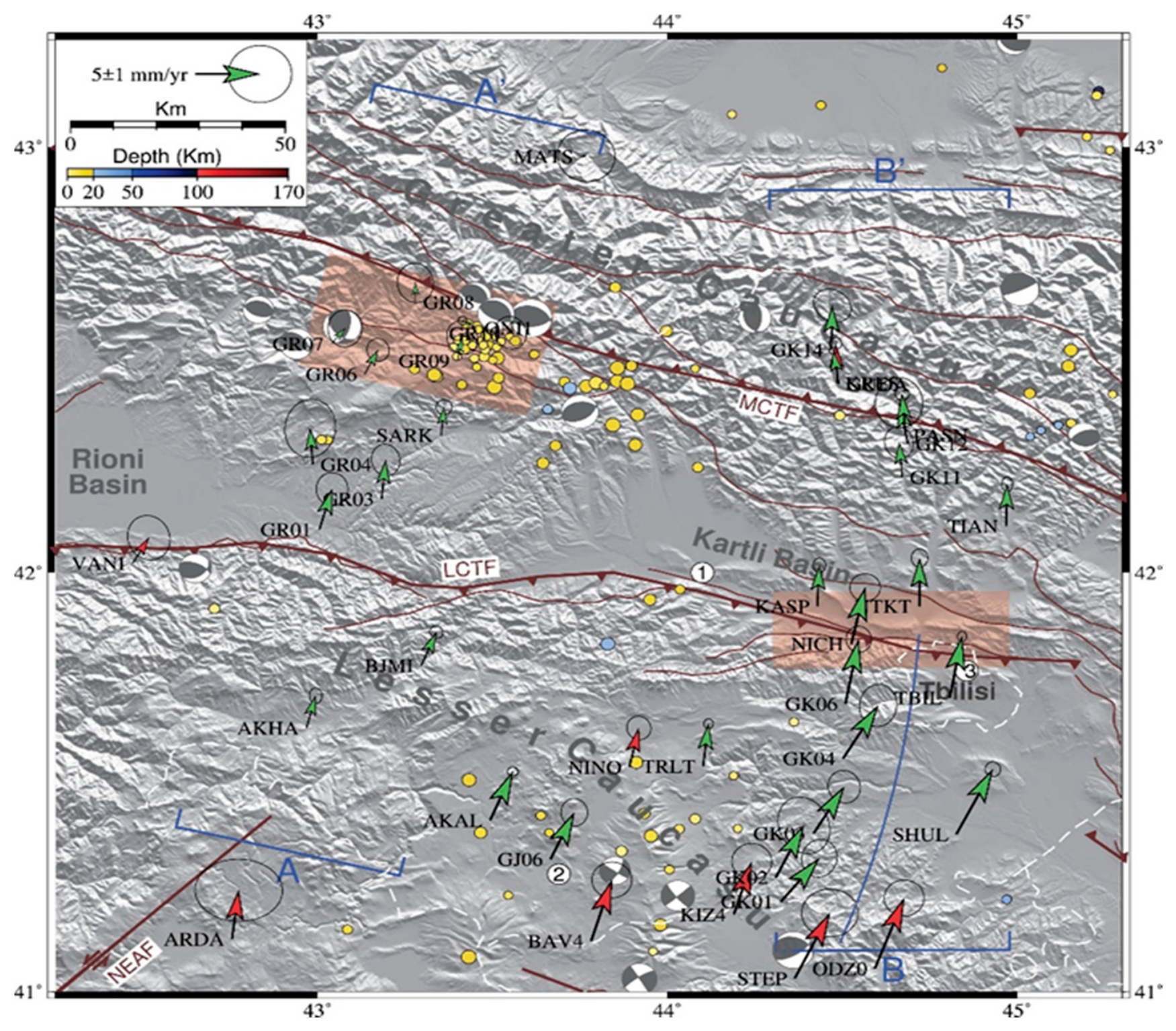
2.3.1. To detect geotectonic anomalies in seismically active regions (countries), it is necessary continuously to conduct geodetic surveys using GPS and GNSS methods [32] as well as quantitatively to estimate the earthquake preparation area. For example, a geotectonic anomaly identified by studies near Tbilisi has the following appearance [26] (Figure 5).
2.3.2. The area of the expected earthquake should be calculated approximately according to the estimated area by [33] formula (1):
R = 10 0.43 M
where R is the strain radius in km, and M is the earthquake magnitude.
2.3.3. In case of an earthquake with an expected magnitude of M≥3, the earthquake prediction studying team should start working in the area and conduct surveys based on the VLF/LF EM emissions existing prior to the earthquake; These surveys should continuously monitor the magnitude of the expected earthquake, determine the coordinates of the future earthquake epicenter, estimate the time of the earthquake occurring, and the probable direction of the main fault in the earthquake focus.
2.3.4. Mobile network for recording electromagnetic radiation in the ELF/VLF ranges can be used for this purpose. They can be deployed even within the territory of small countries and in regions with complex geological structures, such as the aforementioned Georgia [31].
2.3.5. The geometry of the active fault in the focus should be studied, and the displacement direction
along the fault should be specified. It is well-established that surface geological records and deep drilling data are not sufficient for producing a true deep structure nature. Seismic profiles are essential in introducing a complex picture. The success of these studies is largely determined by the application of fault-related folding theory [34]. One of the components of this theory is fault-related folds (fault-bend and fault-propagation folds), the kinematics of which are mainly related to the geometry of the horizontal and ramp segments on which the displacements take place.
2.3.6. The crustal-scale structural cross-sections of the area around the earthquake focus should be constructed using geological and geophysical methods of survey, and taking into account for the geometry and kinematics of the fault (or faults) defined by the above-mentioned studies in the earthquake focus.
2.3.7. Based on the studies, determine the preferred direction of seismic energy radiation from the incoming earthquake focus.
2.3.8. Measures to reduce the risk of the earthquakes occurrence should be determined based on the results obtained from the above studies.
Of course, working in individual countries, due to the whole region's geological structure and the quality of the neighboring countries' urban development, we should be very careful. For example, on (Figs 4, 5) show active faults over the territory of Georgia.
To avoid unforeseen difficulties, it is best to pre-detect a tectonically anomalous area in each seismically active region and, given the ability to predict earthquakes, exactly choose the time of safe impact to the concrete location, for instance, with powerful electrical impulses to reduce the particular tectonic stress.
Naturally, in this case, the choice of the moments of impacts should be carried out taking into account the influences of natural processes too. The scientific results obtained by Russian scientists still requires further detailed research as well as a clearer definition of the possibilities for reducing accumulated tectonic stress for each region (or country) and for a specific major earthquake.
Today, at the modern stage of scientific development, the task of gradually easing the energy accumulated in the focus of a large earthquake for the reduction of tectonic stress is completely real. Thus, in our view, given the possibility of short-term earthquake prediction, research into reducing accumulated tectonic stress may indeed already can be placed on the scientific agenda.
Considering the problem of artificial discharge of tectonic stresses, the authors of the article unequivocally take into account the Convention (ENMOD) prohibiting the military or other hostile use of environmental modification techniques causing earthquakes and tsunamis, and having widespread, long-lasting, or severe effects [35].
3. Conclusions:
In recent years, the founded out possibility of the three-stage warning and short-term forecasting of strong earthquakes based on the study of electromagnetic emissions preceding earthquakes, as well as earlier studies aimed at releasing accumulated tectonic energy, have radically improved the ability to solve the problem of the earthquake occurrence risk reduction, and made it possible the resumption of research in the direction of minimizing tectonic stress. The proposed works must be carried out in the following succession:
3.1. A seismogenic area, where the earthquake preparation process is taking place, should be identified in a specific seismic active region.
3.2. Based on the three-stage methods of early warning and short-term earthquake prediction, the stages of its preparation should be assessed.
3.3. The predictive parameters of the future earthquake, namely: the expected epicenter, magnitude, and time of occurrence of the incoming earthquake, must be estimated.
3.4. To use already existed seismic risk assessment for specific incoming earthquake.
3.5. Among other parameters, the amount and angle of possible radiated energy at the focus of a impending earthquake should be estimated.
3.6. Taking into account the geological features of the seismogenic area and the safety of neighboring urban regions, an effective and reasonable time frame method of impact on the environment should be selected.
3.7. In tectonically dangerous areas, where the large earthquakes preparation process will be studied as much as possible, the tectonic stress has to be artificially reduced by affecting the powerful electrical impulses.
Thus, according to the studies described above, solving the problem of reducing the accumulated tectonic stresses from the approaching strong earthquake the agenda can be put on.
Author Contributions
M.K.: and N.K.-M., formulated the article's purpose, collected the necessary materials, and wrote the article, excluding the geological section. V.A. wrote the geological section, and all three authors revised the manuscript.
Conflicts of Interest
The authors declare no conflicts of interest.
References
- Geller, R.J. Earthquake prediction. Geophys. J. Int. 1997, Volume 131(Issue 3, December), 425–450. [Google Scholar] [CrossRef]
- Uyeda, S.; Nagao, T.; Kamogawa, M. Short-term earthquake prediction: Current status of seismo-electromagnetics. Tectonophysics 2009, 470(3–4), 205–213. [Google Scholar] [CrossRef]
- Ouzounov, D.; Liu, J.Y.; Taylor, P.T.; Hattori, K. Geospace Observation of Natural Hazards. Front. Earth Sci. 2022, 10, 836629. [Google Scholar] [CrossRef]
- Nikolaev, A.V. On the possibility of artificial removal of tectonic stress using seismic and electrical influences. In Double Technologies; (in Russian). 1999; Volume No. 2. [Google Scholar]
- Huang, Youquan; Kong, Cuilong; Deng, Dawei; Wang, Yu; Hou, Baohuai; Liu, Peng; Chen, Tianyu; Zhang, Xiaoyu. New Insights into How the Rupture Radius of Deep Fault Rupture Affects the Magnitude of Induced Earthquakes. MDPI. Appl. Sci. 2026, 16, 5676. 17 p. [Google Scholar] [CrossRef]
- Mirzoev, K.M.; Nikolaev, A.V.; Lukk, A.A.; Yunga, S.L. Induced seismicity and the possibility of controlled discharge of accumulated tectonic stresses in the Earth's crust. Phys. Earth 2009, N 10, 49–68. [Google Scholar] [CrossRef]
- Nikolaev, A.V. Induced seismicity. In Science in Russian; 1997; pp. 14–22. Available online: https://www.eolss.net/sample-chapters/c01/E4-06-01-03.pdf.
- Tarasov, N.T.; Tarasova, N.V.; Avagimov, A.A.; Zeigarnik, V.A. Influence of powerful hydromagnetic generator on seismicity of Central Asia and Kazakhstan. Volcanol. Seismol. (in Russian). 1999, 4-5, 152–160. [Google Scholar]
- Kachakhidze, M.; Kachakhidze-Murphy, N. VLF/LF Electromagnetic Emissions Predict an Earthquake. Open J. Earthq. Res. 2022, 11, 31–43. [Google Scholar] [CrossRef]
- Manana, Kachakhidze; Kachakhidze-Murphy, Nino; Kukhianidze, Vaso; Ramishvili, Giorgi; Khvitia, Badri. For the Classification of Anomalous Geophysical Fields that Existed Prior to an Earthquake. Prev. Treat. Nat. Disasters 2023. [Google Scholar] [CrossRef]
- Kachakhidze, M.; Kachakhidze-Murphy, N.; Ramishvili, G.; Khvitia, B. Three-Stage Early Warning and Short-Term Prediction. Prev. Treat. Nat. Disasters 2024, 3(1). [Google Scholar] [CrossRef]
- Eftaxias, K.L.; Athanasopoulou, G.; Balasis, M.; Kalimeri, S.; Nikolopoulos, Y.; Contoyiannis, J.; Kopanas, G.; Antonopoulos, L.; Nomicos, C. Unfolding the Procedure of Characterizing Recorded Ultralow Frequency, kHZ and MHz Electromagnetic Anomalies Prior to the L’Aquila Earthquake as Pre-Seismic Ones—Part 1. Nat. Hazards Earth Syst. Sci. 2009, 9, 1953–1971. [Google Scholar] [CrossRef]
- Eftaxias, K.; Balasis, G.; Contoyiannis, Y.; Papadimitriou, C.; Kalimeri, M.; Athanasopoulou, L.; Nikolopoulos, S.; Kopanas, J.; Antonopoulos, G.; Nomicos, C. Unfolding the Procedure of Characterizing Recorded Ultra Low Frequency, kHZ and MHz Electromagnetic Anomalies Prior to the L’Aquila Earthquake as Pre-Seismic Ones—Part 2. Nat. Hazards Earth Syst. Sci. 2010, 10, 275–294. [Google Scholar] [CrossRef]
- Mjachkin, V.I.; Brace, W.F.; Sobolev, G.A.; Dieterich, J. Two Models for Earthquake Forerunners. Pure Appl. Geophys. 1975, 113, 169–181. Available online: https://link.springer.com/article/10.1007/BF01592908. [CrossRef]
- Sosson, M.; Stephenson, S.; Sheremet, Y.; Rolland, Y.; Adamia, Sh.; Melkonian, R.; Kangarli, T.; Yegorova, T.; Avagyan, A.; Galoyan, G.; Danelian, T.; Hässig, M.; Meijers, M.; Müller, C.; Sahakyan, L.; Sadradze, N.; Alania, V.; Enukidze, O.; Mosar, J. The Eastern Black Sea-Caucasus region during Cretaceous: new evidence to constrain its tectonic evolution. Compte-Rendus Géosciences 2016, 348, 23–32. [Google Scholar] [CrossRef]
- Alania, V.; Enukidze, O.; Kvavadze, N.; Beridze, T.; Chagelishvili, R.; Giorgadze, A.; Melikadze, G.; Razmadze, A. Crustal-scale duplexes beneath the eastern Rioni foreland basin in western Georgia: A case study from seismic reflection profile. Geosciences 2025, 15(8), 291. [Google Scholar] [CrossRef]
- Alania, V.; Beridze, T.; Enukidze, O.; Gusmeo, T.; Razmadze, A.; Tevzadze, N.; Vashakidze, G.G. Deep structure and deformation structural style of the Georgian part of Lesser Caucasus orogen. In Structural Geology and Tectonics; Mukherjee, S., Ed.; Springer, 2026; pp. 1–14. [Google Scholar] [CrossRef]
- Cowgill, E.; Forte, A.; Niemi, N.; et al. Relict basin closure and crustal shortening budgets during continental collision: an example from Caucasus sediment provenance. Tectonics 2016, 35, 2918–2947. [Google Scholar] [CrossRef]
- Alania, V.; Beridze, M.; Enukidze, O.; Chagelishvili, R.; Lebanidze, Z.; Maqadze, D.; Razmadze, A.; Sadradze, N.; Tevzadze, N. The Geometry of the Two Orogen Convergence and Collision Zones in Central Georgia: New Data from Seismic Reflection Profiles. In Building Knowledge for Geohazard Assessment and Management in the Caucasus and other Orogenic Regions, NATO Science for Peace and Security Series C: Environmental Security; Bonali, F.L., et al., Eds.; Springer, 2021; pp. 73–88. [Google Scholar] [CrossRef]
- Tari, G.; Vrsic, A.; Gumpenberger, T.; Mekonnen, E.; Hujer, W.; Fallah, M.; Tevzadze, N.; Janiashvili, A.; Pace, P.; Ricciato, A.; Alania, V.; Enukidze, O. Eocene volcaniclastic reservoir rocks in the Kartli Basin, Georgia: a fractured reservoir sequence. J. Pet. Geol. 2021, 44(3), 413–434. Available online: https://onlinelibrary.wiley.com/doi/full/10.1111/jpg.12795. [CrossRef]
- Alania, V.; Enukidze, O.; Razmadze, A.; Beridze, T.; Merkviladze, D.; Shikhashili, T. Interpretation and analysis of seismic and analog modeling data of triangle zone: a case study from the frontal part of western Kura foreland fold-and-thrust belt, Georgia. Front. Earth Sci. 2023, 11, 1195767. [Google Scholar] [CrossRef]
- Cavazza, W.; Gusmeo, T.; Zattin, M.; Alania, V.; Enukidze, O.; Corrado, S.; Schito, A. Two-step exhumation of Caucasian intraplate rifts: a proxy of sequential plate-margin collisional orogenies. Geosci. Front. 2024, 15, 101737. [Google Scholar] [CrossRef]
- Corrado, S.; Gusmeo, T.; Schito, A.; Alania, V.; Enukidze, O.; Conventi, E.; Cavazza, W. Validating far-field deformation styles from the Adjara-Trialeti fold-and-thrust belt to the Greater Caucasus (Georgia) through multi-proxy thermal maturity datasets. Mar. Pet. Geol. 2021, 130, 105141. [Google Scholar] [CrossRef]
- Gusmeo, T.; Schito, A.; Corrado, S.; Alania, V.; Enukidze, O.; Zattin, M.; Pace, P.; Cavazza, W. Tectono-thermal evolution of central Transcaucasia: Thermal modelling, seismic interpretation, and low-temperature thermochronology of the eastern Adjara-Trialeti and western Kura sedimentary basins (Georgia). J. Asian Earth Sci. 2022, 237, 105355. [Google Scholar] [CrossRef]
- Alania, V.; Chabukiani, A.; Chagelishvili, R.; et al. Growth structures, piggyback basins and growth strata of Georgian part of Kura foreland fold and thrust belt: implication for Late Alpine kinematic evolution. Geol. Soc. Lond. Spec. Publ. 2017, 428, 171–185. [Google Scholar] [CrossRef]
- Sokhadze, G.; Floyd, M.; Godoladze, T.; King, R.; Cowgill, E.S.; Javakhishvili, Z.; Hahubia, G.; Reilinger, R. Active convergence between the lesser and greater Caucasus in Georgia: Constraints on the tectonic evolution of the lesser-greater Caucasus continental collision. Earth Planet. Sci. Lett. 2018, 481, 154–161. Available online: https://www.sciencedirect.com/science/article/abs/pii/S0012821X17305666. [CrossRef]
- Alania, V.; Chabukiani, A.; et al. Evolution of the Late Cenozoic basins of Georgia (SW Caucasus): a review. Geol. Soc. Lond. Spec. Publ. 2010, 340, 239–259. [Google Scholar] [CrossRef]
- Tsereteli, N.; Tibaldi, A.; Alania, V.; Gventsadse, A.; Enukidze, O.; Varazanashvili, O.; Müller, B. I. R. Active tectonics of central-western Caucasus, Georgia. Tectonophysics 2016, 691, 328–344. [Google Scholar] [CrossRef]
- Biagi, P.F.; Maggipinto, T.; Ermini, A. The European VLF/LF radio network: current status. Acta Geod. Geophys 2015, 50, 109–120. [Google Scholar] [CrossRef]
- Biagi, P.F.; Colella, R.; Schiavulli, L.; Ermini, A.; Boudjada, M.; Eichelberger, H.; Schwingenschuh, K.; Katzis, K.; Contadakis, M.E.; Skeberis, C.; Moldovan, I.A.; Bezzeghoud, M. The INFREP Network: Present situation and recent results. Open J. Earthq. Res. 2019, 8, 101–115. [Google Scholar] [CrossRef]
- Kachakhidze, M.; Kachakhidze-Murphy, N.; Khazaradze, G.; Khvitia, B. An earthquake precursor mobile network. Earthq. Sci. 2021, 34. [Google Scholar] [CrossRef]
- Reilinger, R.; McClusky, S.; Vernant, P.; et al. GPS constraints on continental deformation in the Africa–Arabia–Eurasia continental collision zone and implications for the dynamics of plate interactions. J. Geophys. Res. 2006, BO5411. [Google Scholar] [CrossRef]
- Dobrovolsky, I.P.; Zubkov, S.I.; Mjachkin, V.I. Estimation of the size of earthquake preparation zones. Pure Appl. Geophys 117, 1025–1044. [CrossRef]
- Shaw, J.H.; Connors, C.D.; Suppe, J. Seismic interpretation of contractional fault-related folds. In AAPG Studies in Geology 53; AAPG: Tulsa, OK, USA, 2005; Available online: https://www.researchgate.net/publication/237044237_Seismic_Interpretation_of_Contractio.
- Convention on the Prohibition of Military or Any Other Hostile Use of Environmental Modification Techniques (Environmental Modification Convention (1997). (ENMOD United Nations Convention on Environmental Modification, 18 May. Available online: https://en.wikipedia.org/wiki/Environmental_Modification_Convention.
Figure 1.
Tectonic map of the Arabia-Eurasia collision zone (modified by [15]) (1) Tectonic map of the Caucasus [16]. Abbreviations: GC-Greater Caucasus, LC-Lesser Caucasus, RFFTB-Rioni foreland fold-and-thrust belt, RFB-Rioni foreland basin; IUZ-Imereti uplift zone; ATFTB-Achara-Trialeti fold-and-thrust belt; KFFTB-Kura foreland fold-and-thrust belt; KFB-Kura foreland basin; NCFFTB-North Caucasus foreland fold-and-thrust belt; DWFTB-Deepwater fold-and-thrust belt; KB-Kuban Basin; TB-Terek Basin; AFB-Araks foreland basin.
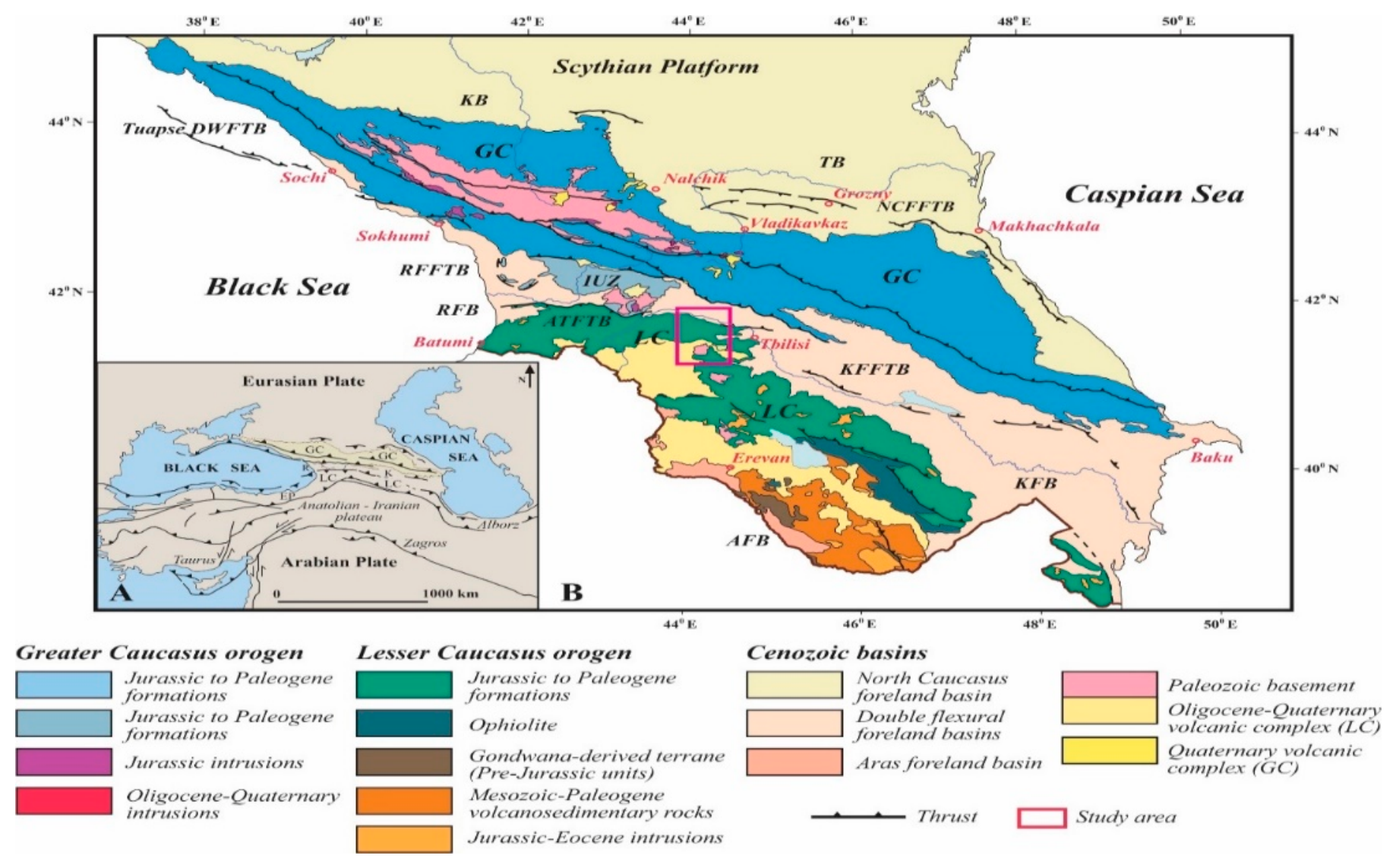
Figure 2.
Geological map of the study and surrounding area (Modified by [17]) AAI and BBI are structural cross-sections. Abbreviations: LC-Lesser Caucasus, ATFTB-Achara-Trialeti fold-and-thrust belt; KFFTB-Kura foreland fold-and-thrust belt.
Figure 2.
Geological map of the study and surrounding area (Modified by [17]) AAI and BBI are structural cross-sections. Abbreviations: LC-Lesser Caucasus, ATFTB-Achara-Trialeti fold-and-thrust belt; KFFTB-Kura foreland fold-and-thrust belt.

Figure 3.
Structural cross-section AAI through the frontal part of the Lesser Caucasus pro-wedge and Kura foreland basin (Modified by [19,20].) Location is shown in Figure 2. Abbreviations: LC-Lesser Caucasus, ATFTB-Achara-Trialeti fold-and-thrust belt; KFFTB-Kura foreland fold-and-thrust belt.

Figure 4.
Structural cross-section BBI through the Lesser Caucasus pro-wedge [17] Location is shown in Figure 2. Abbreviations: GA-Gumbati anticline; PRT – Passive-roof thrust; OS-Oshori syncline; AA-Arjevani anticline; APBT- Arjevani passive-back thrust; KS-Kldekari syncline.
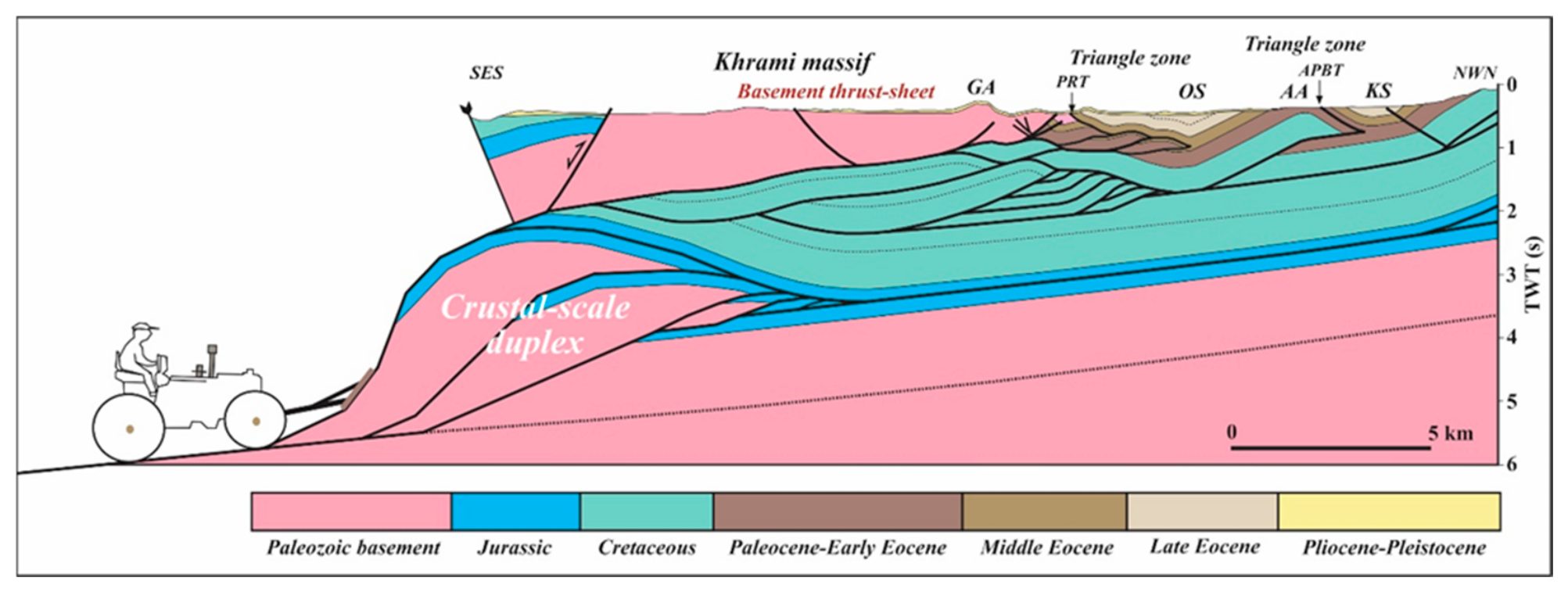
Figure 5.
Map of GPS velocity, faults, and focal mechanisms [26].
Figure 5.
Map of GPS velocity, faults, and focal mechanisms [26].
Disclaimer/Publisher’s Note: The statements, opinions and data contained in all publications are solely those of the individual author(s) and contributor(s) and not of MDPI and/or the editor(s). MDPI and/or the editor(s) disclaim responsibility for any injury to people or property resulting from any ideas, methods, instructions or products referred to in the content. |
© 2026 by the authors. Licensee MDPI, Basel, Switzerland. This article is an open access article distributed under the terms and conditions of the Creative Commons Attribution (CC BY) license (http://creativecommons.org/licenses/by/4.0/).
Copyright: This open access article is published under a Creative Commons CC BY 4.0 license, which permit the free download, distribution, and reuse, provided that the author and preprint are cited in any reuse.