
Submitted:
01 October 2026
Posted:
06 October 2026
You are already at the latest version
Abstract
The Romilly region, situated at the junction of two major geological features of the Paris Basin, exhibits numerous Quaternary deformations. The origin of these deformations has been the subject of conflicting publications: seismites versus periglacial. The existence in Gélannes of an anthropogenic pit dating from the Late Bronze Age, affected by a fault approximately 0.35 m high, has reignited the debate. Thus, periglacial deformations may have been reactivated by a Holocene earthquake, thereby explaining, amongst other things, the flame-like structures and faults. This is all the more likely given that Holocene faults are found at Sauvage, as are late-stage injections of chalk mud reaching the surface. The intersection of the Saint Martin and Sézanne faults could be the cause of the observed deformations. Petroleum seismic surveys thus show that, locally, the Saint Martin fault extends up to the top of the chalk. The epicentre is likely to be found near the most deformed sites at Marcilly and Sauvage. This seismic hypothesis also corroborates the conclusions of Damon et al. (2023). This author suggests a potential current slip on the Vittel and Saint Martin faults, as a result of the melting of the Scandinavian glaciers. It is also interesting to note a higher local geothermal flux at Saint Just Sauvage (98 mW/m² compared with 86 mW/m² in the Paris Basin), likely linked to heterogeneities at the base of the crust. This author suggests that the Vittel and Saint Martin faults may currently be active again, as a result of the melting of the Scandinavian glaciers. It is also interesting to note a higher geothermal flux locally at Saint Just Sauvage (98 mW/m² compared with 86 mW/m² in the Paris Basin), which is likely linked to heterogeneities at the base of the crust. This type of thermal anomaly is sometimes put forward as an explanation for intraplate earthquakes.
Keywords:
Paris Basin
; Saint Martin Fault
; seismite
; neotectonics
1. Introduction
The Paris Basin is an intracratonic basin with very low seismicity, situated in the foreland of the Alpine orogen, which was active during the Neogene. According to the Cara catalogue (2015), three small earthquakes have occurred locally since 1963.
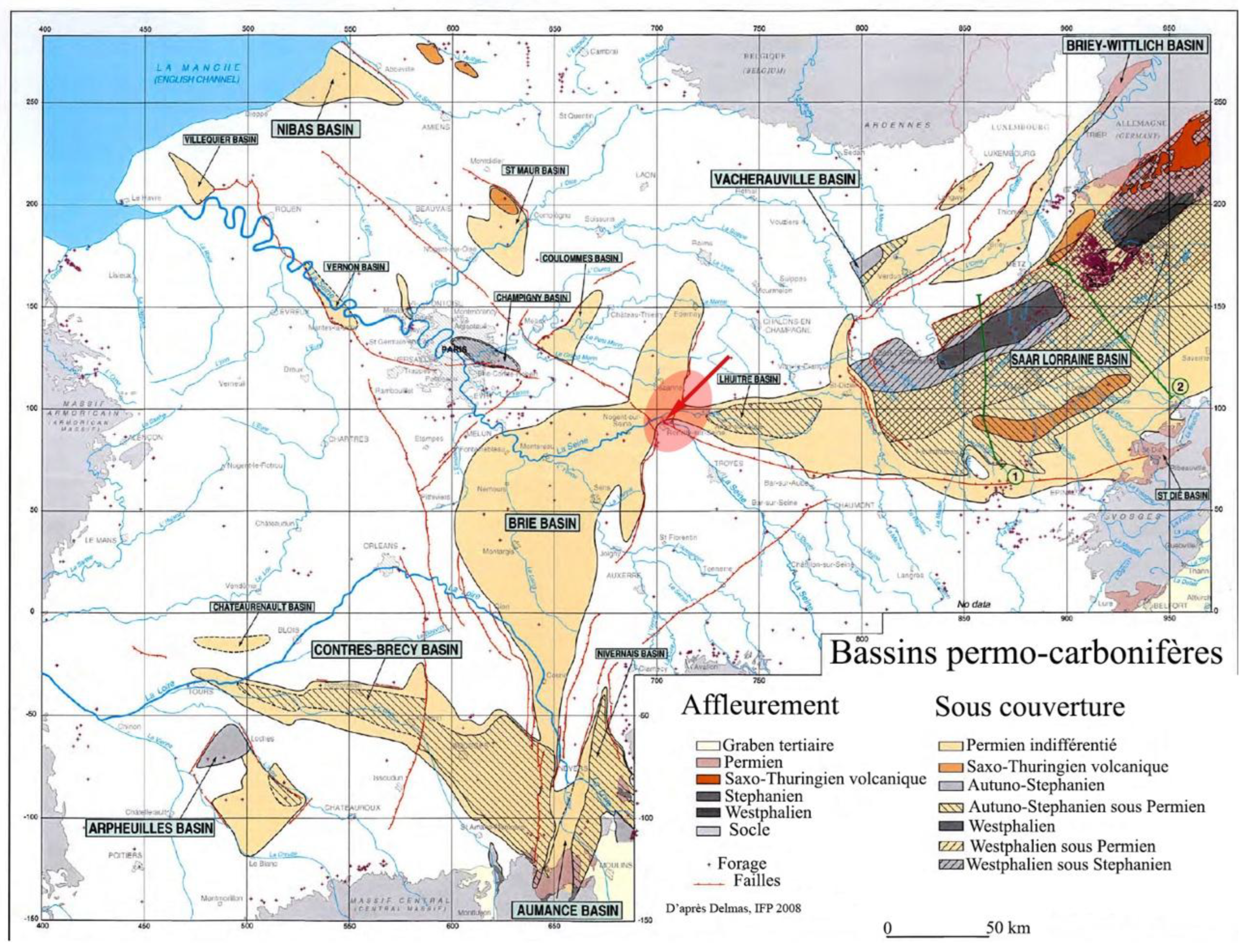
Figure 1.
Structural map and location of the study area.
Two recognised indicators of neotectonic activity are recorded in the national databases (Baize et al., 2002; Baize et al., 2013; Jomard et al., 2017).
Further evidence of deformation is also present (Figure 2).
Within the intraplate domain, the Paris Basin is characterised by inherited Variscan faults cutting through a thick Mesozoic–Cenozoic cover (Wyns et al., 2016).
Apart from these two indications of neotectonic activity, there has been no evidence to date to suggest any Quaternary tectonic activity in this area where the Bray-Vittel and Saint Martin de Bossenay faults intersect. The discovery of actual evidence of this activity (fluid ejections, faults, punched gravel, loadcasts, fractured alluvial flint, flame-like structures, etc.) just as a faulted man-made pit forces us to conclude that there was at least one earthquake of magnitude greater than 5 during the Holocene.
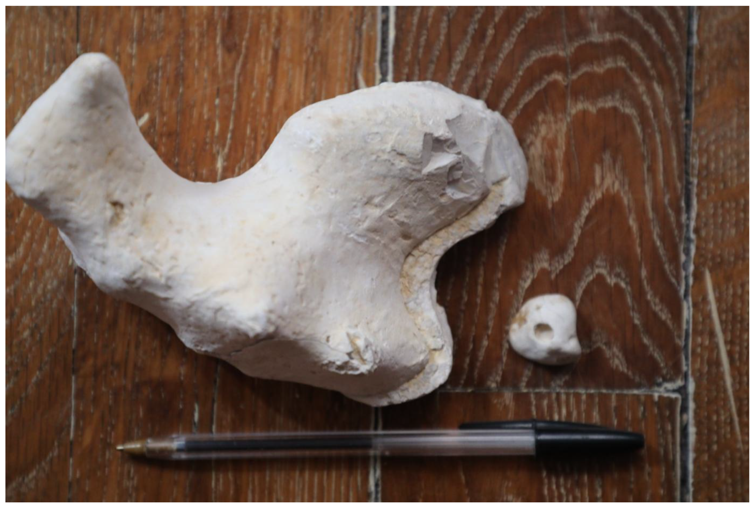
Figure 3.
Fractured flint in alluvial deposits and perforated alluvial gravel. The fracturing of the flint dates from the Cenozoic era or later. The perforation of the gravel, on the other hand, dates from the Pleistocene or later.
Figure 3.
Fractured flint in alluvial deposits and perforated alluvial gravel. The fracturing of the flint dates from the Cenozoic era or later. The perforation of the gravel, on the other hand, dates from the Pleistocene or later.
This discovery could only have been fortuitous, resulting from alluvial quarrying and archaeological excavations in a heavily human-modified area.
These excavations are situated in the immediate vicinity of the eastern terminus of the Bray Fault (Malnoue Fault) and its intersection with the Saint Martin Fault to the south and the Sézanne Fault to the north. The deformations, meanwhile, are in the Seine valley, less than two kilometres west of the Sézanne Fault. Three minor earthquakes have been recorded in the area since 1963 (Cara, 2015).
These findings form part of a series of recent discoveries. Although anticipated by some (Benoit et al., 2013), Baize et al. (2026) demonstrated this further to the north-west. Our work thus builds on these authors’ research into Quaternary activity of intraplate faults in the Paris Basin.
2. Regional Tectonic Context (Figure 4)
2.1. The Pays de Bray-Vittel Fault (Figure 5)
The Paris Basin forms part of a vast Mesozoic–Cenozoic sedimentary domain, characterised by a broad monoclinal structure dipping towards the east–west depositional centre. It rests on a Palaeozoic and Proterozoic basement, which was structured during the two major tectonic phases of the Upper Palaeozoic: the Caledonian and Variscan orogenies (Gély et al., 2014).
The Pays de Bray fault causes a relative uplift of the south-western compartment. The ECORS seismic profile clearly illustrates this, highlighting a marked discontinuity, dipping southwards at depth (Cazes et al., 1985).
It continues towards the south-east via the Vittel Fault. Its intersection with the Saint Martin de Bossenay meridian fault at Romilly-sur-Seine, within our study area, is manifested by a Permian basin bounded to the east by the Sézanne Fault and to the west by the Romilly Fault (Benoit & Grisoni, 1992).
Figure 5.
Seismic section through the Romilly tectonic rift. The thick Permian Romilly Basin is bounded by a major fault, the La Folie de Paris fault (also known as the Romilly fault), which is thought to strike more or less meridian. Its location corresponds to the confluence of two major basement faults in the Paris Basin: the Bray Fault and the Saint Martin Fault (According to the Seismic Atlas of France, 2009. Depth in double-time seconds (sTD).

The Vittel Fault is one of the major faults in the Paris Basin. Running east–west, it separates the Hercynian isopic zones: the Saxo-Thuringian zone to the north and the Moldanubian zone to the south.
Viewed from the north, it acts as a normal fault in the Upper Triassic. It is virtually inactive during the Jurassic. The formation of the narrow graben flanking it to the north is probably post-Jurassic. Oriented east–west, it was probably deformed during the Pyrenean phase of the Upper Eocene. Its course through the Upper Cretaceous is not visible in petroleum seismic data. Manifesting itself there as numerous fault striations and fracturing of flint recemented by iron sulphides, this suggests that it began to slip as early as the Cenomanian.
2.2. The Saint Martin de Bossenay Fault
For oil explorers, it corresponds to the southerly extension of the coal seam.
It has been active throughout the evolution of the Paris Basin.
This fault separates a stable eastern compartment, onto which a relatively thin sequence is deposited, from a much more subsiding western compartment. Activity along this fault was at its peak from the Triassic to the Dogger. The period between the Kimmeridgian and the Portlandian was one of tectonic quiescence. A post-Campanian compressional phase is responsible for the tectonic inversion of the margin of the extensional structure. Finally, a submeridian extensional phase, evident throughout the southern part of the Paris Basin, caused this fault to revert to a normal fault, causing the western compartment to collapse once again. This final phase is partly responsible for the closure (‘roll-over’) of the St Martin de Bossenay structure. It affects the top of the local chalk (Lower Campanian), at least as far north as the Seine.
3. Materials and Methods
In addition to the available petroleum data, this study is primarily a geological field study.
¹⁴C dating was carried out by Beta Analytic in Miami (USA). Two further dates were obtained using OSL.
Photographs of outcrops, cleaned first with a spade and then with a brush, were processed using Photoshop, sometimes in outline mode.
Initially, potential faults were investigated using electrical tomography in Wenner-Schlumberger mode (Dahlin & Zhou, 2004) and high-resolution seismic reflection (Piwakowski, 2005).
According to the electrical tomography profiles, the uncertainty ranges between 2 and 8 per cent, based on three successive iterations of signal inversion. In addition to indicating the base of the sedimentary fill, these profiles show chalk with variable resistivity and upwelling of low-resistivity chalk diapirs, or even sand or silt.
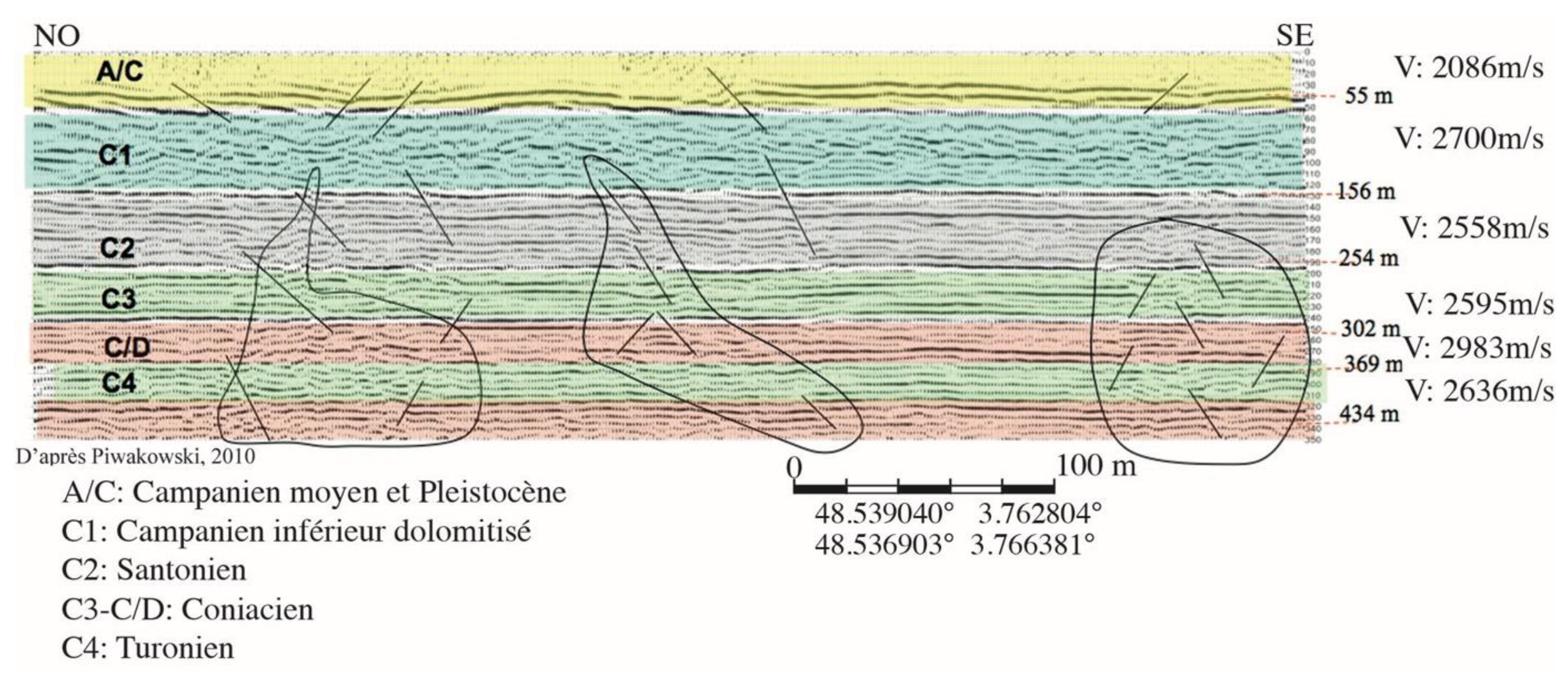
Three high-resolution seismic profiles were acquired at Longueville, Charny and Sauvage. The latter (Mari et al. 1998), which runs obliquely to the Vittel Fault identified in petroleum seismic surveys, intersects the Sézanne Fault. Measuring 500 m in length, it comprises 160 shots spaced 3 m apart. The geophones used have a cut-off frequency of 28 Hz. The seismograph is a Geometrics Strata Visor (24-bit) with 48 acquisition channels. Data processing was carried out using the CDP (Common Depth Point) method. This was performed using the WINSEIS seismic processing software and proprietary programmes developed in Matlab at the École Centrale de Lille. The depth of investigation is approximately 400 m. The accuracy of depth and velocity measurements is of the order of 3 per cent.
Figure 6.
High-resolution seismic profile. Shows the partially dolomitized Lower Campanian. Faulted, unstructured sections extend back to the Pleistocene.
Figure 6.
High-resolution seismic profile. Shows the partially dolomitized Lower Campanian. Faulted, unstructured sections extend back to the Pleistocene.
4. Recent Deformations and Seismicity
Current seismicity is virtually non-existent, apart from three small earthquakes of magnitude 2.5 since 1963. Why are there no historical earthquakes in our study area? This absence appears to be linked both to the low rates of current deformation and to the significant weight of the sedimentary overburden (Petit et al. 2018). The map of earthquakes in France for the period 1962–2020 seems to confirm this (Cara, 2015).
4.1. Neotectonic
There are also two documented neotectonic features (Figure 4).
The northernmost relates to the Gourgançon site, featuring reverse faults and sand ejections within chalk gravelly clay. The 1:5,000 geological map of Fère Champenoise (Mégnien et al., 1977) locates it at the intersection of two faults identified by micropalaeontology and electrical tomography – faults that are invisible in petroleum seismic surveys. Should these be interpreted as detaching faults?
The southernmost site is Longueville-sur-Aube, within a Saalian terrace in the Aube department. It reveals a 15-metre-long reverse fault cutting through a north–south sand pit. A very high-resolution seismic profile (with a 0.5-metre spacing between shots, etc.) carried out by the École Centrale de Lille shows faults extending into the underlying chalk for over 30 metres.
In addition, there are fissures filled with terrigenous material or reverse faults in the chalk overlying Quaternary silts, in the neighbouring quarry at Chary-le-Bachot (Figure 7).
Other findings are surprising. The diversion of the Seine by the Vittel Fault over a distance of 15 km is one such example.
In this context, the discovery of a Quaternary fault affecting a Late Bronze Age archaeological site in the immediate vicinity of the Saint Martin Fault, as well as Holocene deformations characteristic of earthquakes, suggests a partially seismic origin.
4.2. Alluvial Deformations
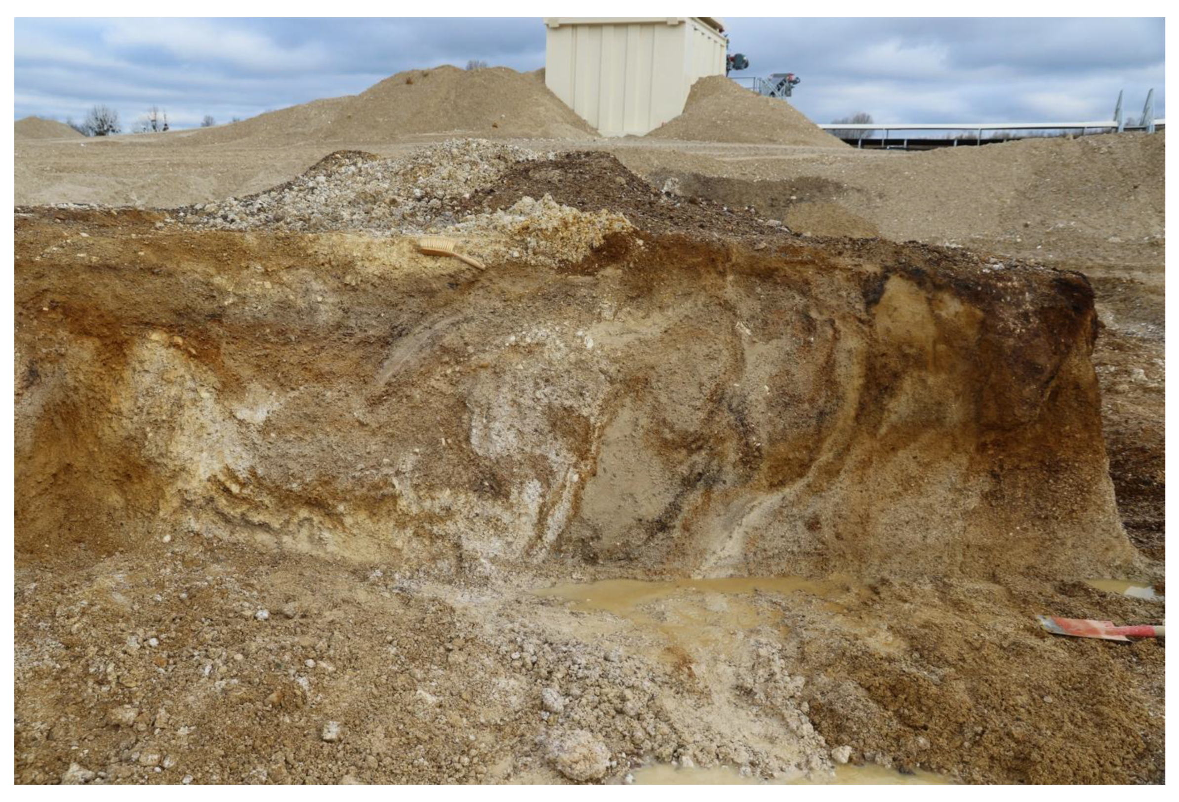
In the Seine valley, to the west of the Sézanne Fault, certain features are characteristic of co-seismic deformations. These include, amongst others, load casts and flame-like structures (Figure 8 and Figure 9).
Others may be linked to both periglacial conditions and/or seismic activity. These may include faults, fluid ejections or gravity-induced landslides (Figure 10).
All of them affect the exposed part of the terrace during low-water periods, i.e. up to two metres.
The sediments in question consist of gravel overlain by eolian loess. At the top, there is a layer of gravel or sand and flood-deposited silt. Depending on the layer in question, their age ranges from 25,000 BP to the present.
The size of the fluid ejections ranges from one decimetre to 0.5 m, affecting sand or silt.
The same applies to the faults, some of which can reach 0.4 m. Once again, the entire deposit extends down to the surface soil horizon (Figure 11)
Other faults are also found on the site, all of which affect the top of the alluvial deposits (Figure 12).
The petroleum seismic profiles from the 1980s show these deformations directly beneath a Triassic graben superimposed on the Vittel Fault.
In addition, there are upwelling zones of chalk mud that cut cleanly through the alluvial mass (Figure 13 and Figure 14). These upwelling zones may be of either seismic or periglacial origin.
Figure 13.
Ejection of gravel associated with an upwelling of chalk. This is accompanied by the ejection of iron and manganese salts in an oxidising environment. The section is 1.6 metres high.
Figure 13.
Ejection of gravel associated with an upwelling of chalk. This is accompanied by the ejection of iron and manganese salts in an oxidising environment. The section is 1.6 metres high.
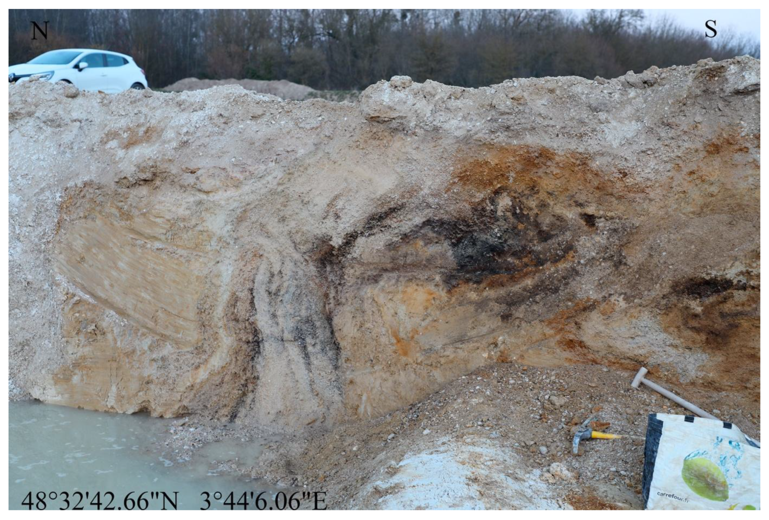
Figure 14.
Ejection of chalk mud and iron-rich concretions. The brush (0.3 m) serves as a scale.
Figure 15.
Massive ejection of sand and silt. The 1.6-metre-high section shows a massive ejection extending down to the soil horizon. Note also the presence of certain settlement faults extending up to the surface. Reminiscent of a mud volcano, its formation appears to have occurred very late and is unrelated to any periglacial phenomenon.
4.3. Déformations Archéologiques.
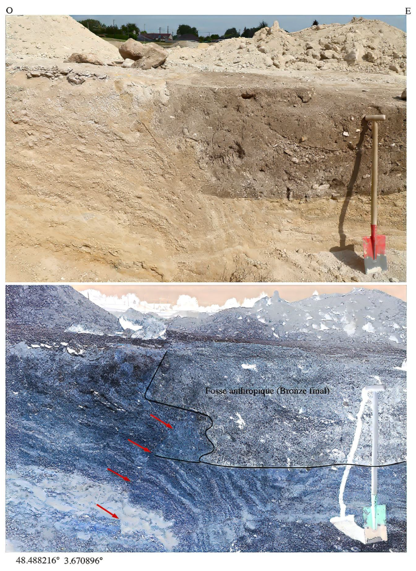
Lors de fouilles préventives à la création d’une maison de retraite, à Gélannes, furent découvert un alignement de pierres levées (grés yprésien) effondrées. Une fosse anthropique dans des grèzes litées, datée du Bronze terminal, est traversée par une faille d’environ 0, 35 m de rejet.
Figure 16.
Fault affecting an anthropogenic pit at Gélannes.
5. Discussion
5.1. Tertiary Seismites
Deformations of seismic origin are known to occur in the Cenozoic strata of the Paris Basin.
Notable examples include the Ypresian seismites of the Île-de-France cuesta [Inventory of Geological Heritage CHA 035]. Added to these are those of the Bartonian, between Château-Thierry and Soissons (Montenat et al., 2007), and those of the Stampian in the vicinity of Etampes. Clustered within a radius of 120 km, all these deformations, attributed to earthquakes of magnitude greater than 6, occurred outside glacial periods.
According to the criteria for earthquake-related deformation (Owen and Moretti, 2011), the following are required: (1) a wide geographical extent; (2) lateral continuity of the deformed sediments; (3) vertical repetition; (4) a morphology of the hydroplastic deformation structures comparable to those described in earthquake-affected sediments; (5) proximity to seismically active faults; and (6) zoning of the complexity and/or frequency of the structures in relation to the distance from the triggering fault.
These criteria are present in our study area. The periglacial age is equally relevant.
Various authors have attempted to distinguish the origin of these deformations (Seilacher 1984; Wheeler 2002). Overall, apart from their age, nothing seems to effectively distinguish co-seismic deformations from periglacial ones.
Thus, various faults, with displacements of up to 0.3 m, extend to the surface, often intersected by the plough pan. It would seem logical to attribute a recent origin to them. It is difficult to link them to the late collapse of thermokarst (Figure 17).
5.2. The Deformations Observed
In the broader regional context of northern France, brittle structures cutting through Quaternary deposits and their Cretaceous substratum, such as those observed at Longueville and Gourgançon, are exceptions if one accepts the very high-resolution seismic data or electrical tomography results
They most often result from periglacial processes (e.g. ice wedge moulds, slope decompression) or, more frequently, from localised dissolution of the underlying chalky substratum, such as karst subsidence and sinkholes (Antoine et al., 2016; Antoine & Limondin-Lozouet, 2024; Baize et al., 2007; Bertran et al., 2017; Van Vliet-Lanoë et al., 2017).
As regards these two sites, no sinkholes or karst chasms have been observed, according to the LiDAR digital elevation model (DEM) of France. Furthermore, no artificial cavities are recorded in the national database. At most, a few rare depressions associated with isolated instances of dolomitisation of the Lower Campanian chalk can be observed. A periglacial origin therefore seems unlikely, as the brittle deformations at Gourgançon and Longueville are anchored in the chalk substrate.
The same applies to the landforms at Charny-le-Bachot.
For their part, those at Marcilly, Sauvage and Gélannes bear no morphological resemblance to the periglacial structures of north-western France, such as ice-cube pseudomorphs or thermokarst collapses, which are incompatible with the Holocene age of some of our landforms. Their shapes strongly resemble structures associated with an earthquake (Ringrose, 1988). It should also be noted that at the Weichselian glacial maximum, the glaciers reached as far north as London.
5.3. Implications for the Assessment of Seismic Hazard
The recent nature of the observed deformations raises questions about the local seismic hazard. The Paris Basin is classified as an area of very low seismicity, with no requirement for seismic design regulations, including for sensitive infrastructure (buildings and bridges).
The Bray-Vittel and Saint Martin faults do not appear in the
French Database of Potentially Active Faults (BDFA) (Jomard et al., 2017). Only the Bray fault is described as a neotectonic structure with very low activity (Baize et al., 2013). This is the largest geological structure in the immediate vicinity of our study area: a deeply rooted fault, dipping towards the south-west.
The most recent Quaternary deformations are found in the immediate vicinity of major geological features associated with the Romilly tectonic rift. These deformations most often extend up to the surface soil horizon, sometimes affecting it. Based on flame-like structures, fluid ejections, as well as conjugate Holocene faults or massive ejections, it must be assumed that an earthquake of magnitude 6 or greater occurred.
Figure 18.
Summit ejections in fine sands. The fine, water-rich sediments are locally liquefied, with explosive overpressure rising to the surface within the soil horizon.
Figure 18.
Summit ejections in fine sands. The fine, water-rich sediments are locally liquefied, with explosive overpressure rising to the surface within the soil horizon.
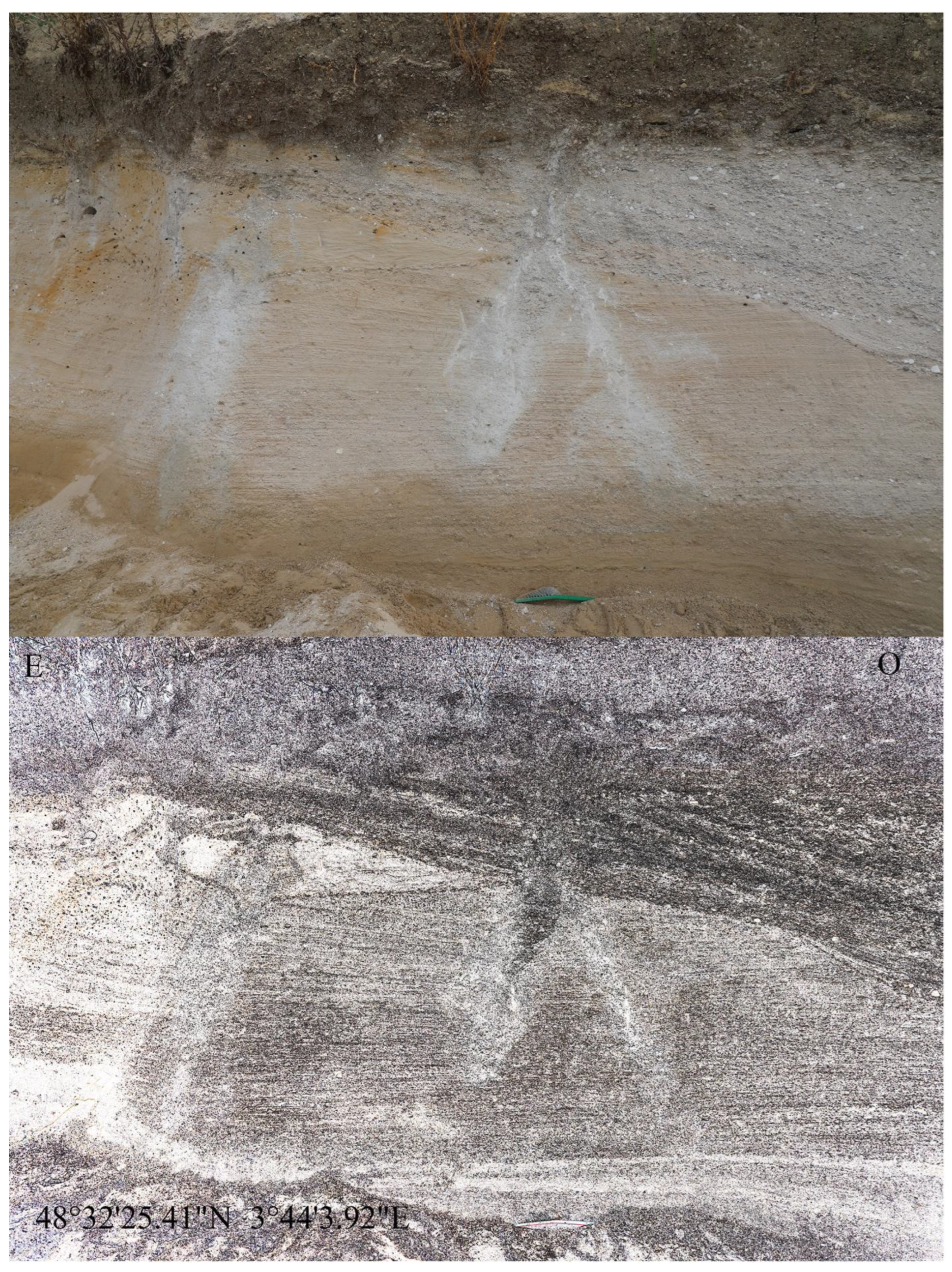
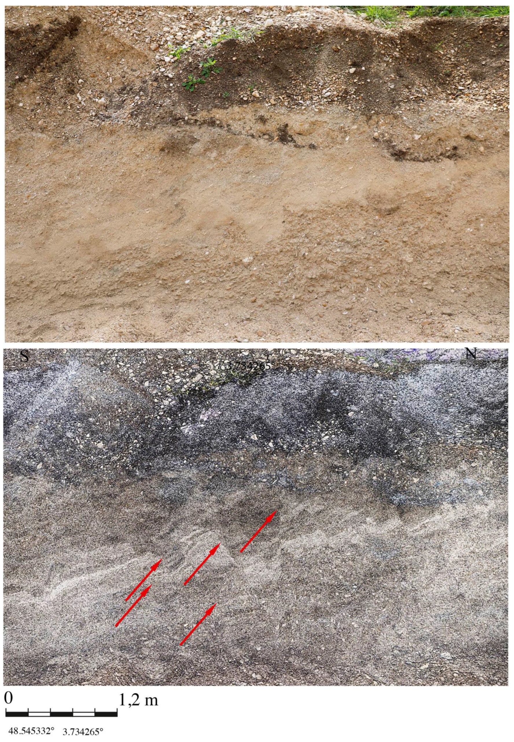
Figure 19.
Holocene conjugate faults.
Furthermore, the presence of numerous muddy chalk diapirs, coupled with extensive iron-rich deposits and black manganese oxide deposits, also suggests Holocene degradation of tephra by organic acids, including those from Laachersee (Figure 20) (12,000 BP). The soluble organic-mineral complexes derived from these tephra deposits are thought to have been rapidly ejected during a major earthquake before being immobilised by oxidation at an alkaline pH.
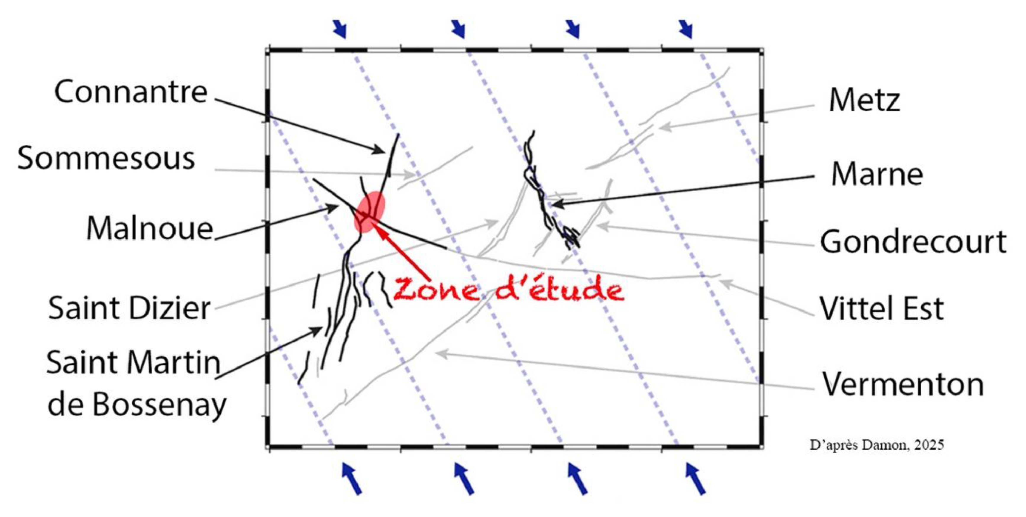
To date, nothing is known about the recurrence of this earthquake or its cause. A link to isostatic readjustment has been suggested by Damon et al. (2023) (Figure 21). These authors point to a potential current reactivation of the Vittel and Saint Martin faults, as a result of the melting of the Scandinavian glaciers. It is also worth noting that there is a higher geothermal flux locally at Saint Just Sauvage (98 mW/m² compared with 86 mW/m² in the Paris Basin), which is likely linked to heterogeneities at the base of the crust [Gaulier & Burrus, 1994]. This type of thermal anomaly is sometimes proposed as an explanation for intraplate earthquakes, such as that at the Middle Durance fault [Mazabraud, 2005].(Figure 21)
6. Conclusions.
The possibility of an earthquake of magnitude 6 or greater occurring in the heart of the Paris Basin is intriguing. Why are there no historical records of earthquakes in our study area? This absence appears to be linked both to the low rates of current deformation and to the significant weight of the sedimentary overburden [Petit et al. 2018]. The map of earthquakes in France for the period 1962–2020 appears to confirm this [Cara, 2015].
Furthermore, why do such deformations occur? If we assume that periglacial deformations were triggered by an earthquake, we must account for a site-specific effect linked to the different sound velocities (dolomitic chalk: 3,500–4,000 m/s at most; weathered chalk: 2,000 m/s or less). Another question also arises, namely that of the triggering fault.
Furthermore, the epicentre of this earthquake is not precisely known, nor are its focal depth and recurrence.
All in all, this is a high-magnitude intraplate earthquake that still raises many questions regarding its exact origin.
Acknowledgments
They are addressed to the anonymous sponsors of the geophysical surveys and dating work. They are addressed to the staff at Morgani, who saved us many hours of stripping work. Finally, they are addressed to the geologists who visited the site, and in particular to J.C. Plaziat for his insightful comments.
Conflicts of Interest
The authors declare no conflicts of interest.
References
- ANTOINE, P., S. COUTARD, G. GUERIN, L. DESCHODT, E. GOVAL, J.-L.
- LOCHT and C. PARIS. Upper Pleistocene loess-palaeosol records.
- from Northern France in the European context: environmental.
- background and dating of the middle palaeolithic”, Quat. Int.411, 2016, 4–24.
- ANTOINE, P. and N. LIMONDIN-LOZOUET. Late middle pleistocene.
- (MIS 10–6) glacial–interglacial records from loess–palaeosol.
- and fluvial sequences from northern France: a cyclostratigraphic approach”, Boreas 53, 2024, 476–503.
- BAIZE, S., E. M. CUSHING, F. LEMEILLE, T. GRANIER, B. GRELLET, D. CARBON,.
- P. COMBES and C. HIBSCH. -Inventaire des indices de rupture affectant le Quaternaire en relation avec les grandes structures connues, en France métropolitaine et dans les régions limitrophes”, in Mémoires hors-séries, Société. Géologique de.
- France: Paris. 2002.
- BAIZE, S., M. COULON, C. HIBSCH, M. CUSHING, F. LEMEILLE and.
- E. HAMARD. -Non-tectonic deformations of Pleistocene sediments.
- in the eastern Paris basin, France, Bull. Soc. Géol. Fr.178, 2007, 367–381.
- BAIZE, S., E. M. CUSHING, F. LEMEILLE and H. JOMARD.-Updated.
- seismotectonic zoning scheme of Metropolitan France, with reference to geologic and seismotectonic data, Bull. Soc. Géol.Fr. 184, 2013, 225–259.
- BAIZE, S. and J.-F. RITZ. -Post-publication careers : ground ruptured,.
- community united”, Commun. Earth Environ. 3, 2022, article 61.
- BAIZE S., ANTOINE P., LOCHT J.L.-Was the Pays de Bray fault an active structure during the Upper Pleistocene ? The contribution of the“Beauvais La Justice” palaeolithic site (France)’’ Comptes Rendus. Géoscience, 358 ,2026, 369-389.
- BECCALETTO, L., F. HANOT, O. SERRANO and S. MARC.-Overview of.
- the subsurface structural pattern of the Paris Basin (France): insights from the reprocessing and interpretation of regional seismic lines”,Mar. Pet. Geol. 28, 2011, 861–879.
- BENOIT P., GRISONI J.M . -Aspects de la tectonique profonde de sub-surface et de surface dans le Sud-Ouest champenois’’. Bull. Inf. Géol. Bassin de Paris. Vol. 28, 4, 1992, 75-83.
- BENOIT P., MEGHRAOUI M., GRISONI J.M.-Quaternary faulting in the central Paris basin: Evidence for coseismic rupture and liquefaction’’. 4 th international INQUA Meeting on Paleoseismology. Active tectonics and Archeology (PATA), Aachen, Germany, 2013, 1-3.
- BERTRAN, P., E. ANDRIEUX, P. ANTOINE, L. DESCHODT, M. FONT and.
- D.SICILIA. -Pleistocene involutions and patterned ground in France: examples and analysis using a GIS database, Permafr. Periglac.Process. 28, 2017, 710–725.
- CARA, M., Y. CANSI, A. SCHLUPP. -SI-Hex: a new catalogue.
- of instrumental seismicity for metropolitan France”, Bull. Soc.
- Géol. Fr. 186, 2015,3–19.
- AZES, M., G. TORREILLES, C. BOIS. -Structure de la croute hercynienne du Nord de la France ; premiers résultats du profil ECORS”, Bull. Soc. Géol. Fr. I, 1985, 925–941.
- DAHLIN & ZHOU. -A numerical comparison of 2D resistivity imaging with 10 electrode arrays,” Geophysical prospecting, 52 (5), 2004. 379–398. [CrossRef]
- DELMAS J., HOUEL P., VIALLY R. -Paris basin. Petroleum potential. Institut français du pétrole. Report 59994, 2007, 22, 24.
- JOMARD, H., E. M. CUSHING, L. PALUMBO, S. BAIZE, C. DAVID and T. CHARTIER. - Transposing an active fault database into a seismic hazard fault model for nuclear facilities—Part 1: building a database of potentially active faults (BDFA) for metropolitan France, Nat. Hazards Earth Syst. Sci. 17, 2017, 1573–1584.
- GELY, J. P., F. HANOT, F. AMEDRO, et al. - Le Bassin parisien, un nouveau regard sur la géologie,’ Mémoire hors-série, Bulletin d’Information des Géologues du Bassin de Paris. 2014.
- GAULIER JM., BURRUS J.- ‘’Modeling present and past thermal regimes in the Paris basin : petroleum implications. 1994. 66-73. In Hydrocarbon and petroleum geology of France. Springer-Verlag,.
- GEOTER. -Rapport GTR/EDF/0212-899Av2, 2012, 14.
- 35. INSTITUT FRANÇAIS DU PETROLE ET DES ENERGIES NOUVELLES. - Atlas sismique de la France, 2009, 8.
- INVENTAIRE DU PATRIMOINE GEOLOGIQUE CHA 035.
- MARI J-L., ARENS G., CHAPELLIER D., GAUDIANI P.-Géophysique de gisement et de génie civil. Éditions Technip,1998, 340-367.
- MAZABRAUD Y.-Deformation active d’une region intraplaque à deformation lente : Le cas de la France. ‘’Sismicité et modélisations thermomécaniques 2D et 3D. Géologie appliquée. Université Nice Sophia Antipolis, 2005, 150. HAL Id: tel-00010156.
- MEGNIEN F., DUTIL P.,MONCIARDINI C. -Carte géologique Fère Champenoise au 1/50000., 224. BRGM éd.1977.
- MONTENAT C., BARRIER P., OTT D’ESTEVOU P and HIBSCH C. -Seismites: an attempt at critical analysis and classification. Sedimentary Geology, 2007, 5-30,196.
- OWEN G. & MORETTI M. -Identifying triggers for liquefaction-induced soft-sediment deformation in sands’’. Sedimentary Geology, 235 (3-4),2011, 41-147.
- PETIT, C., L. DE BARROS, G. DUCLAUX and Y. MAZABRAUD.-Why are.
- there no earthquakes in the intracratonic Paris basin? Insights from flexural models”, Geosciences 9 , 2019, 502.
- PIWAKOWSKI B. Imagerie de la structure de subsurface par sismique haute résolution sur le site de Sauvage .Société SOVEP-École Centrale de Lille.2010.
- RINGROSE. P -Paleoseismic liquefaction event in late Quaternary lake sediments at Glen Roy, Scotland.1998. Terra Nova 1,57-62.
- SEILACHER A. Sedimentary structures tentatively attributed to seismic events. Marine Geology, 55,1984, 1-12.
- VAN VLIET-LANO., B., J. BRULHET, P. COMBES, C. DUVAIL, F. EGO, S. BAIZE.
- and I. Cojan.- Quaternary thermokarst and thermal erosion features in northern France: origin and palaeoenvironments”, Boreas 46 .2017, 442–461.
- WYNS, R., A.DUPERRET and R. N.MORTIMORE. “La tectonique tertiaire.
- dans le sud de l’Angleterre et l’ouest du Bassin de Paris : le concept d’inversion tectonique et les pièges d’hydrocarbures,Bull. Inf. Géol. Bass. Paris 53, 2016, 27–33.
Figure 2.
Indications of Quaternary deformation. (Source: Google Earth Pro). These include fluid outflows, faults, gravity-induced landslides and chalk upheavals. The most significant of these are concentrated around the Vittel and Sézanne faults.
Figure 2.
Indications of Quaternary deformation. (Source: Google Earth Pro). These include fluid outflows, faults, gravity-induced landslides and chalk upheavals. The most significant of these are concentrated around the Vittel and Sézanne faults.
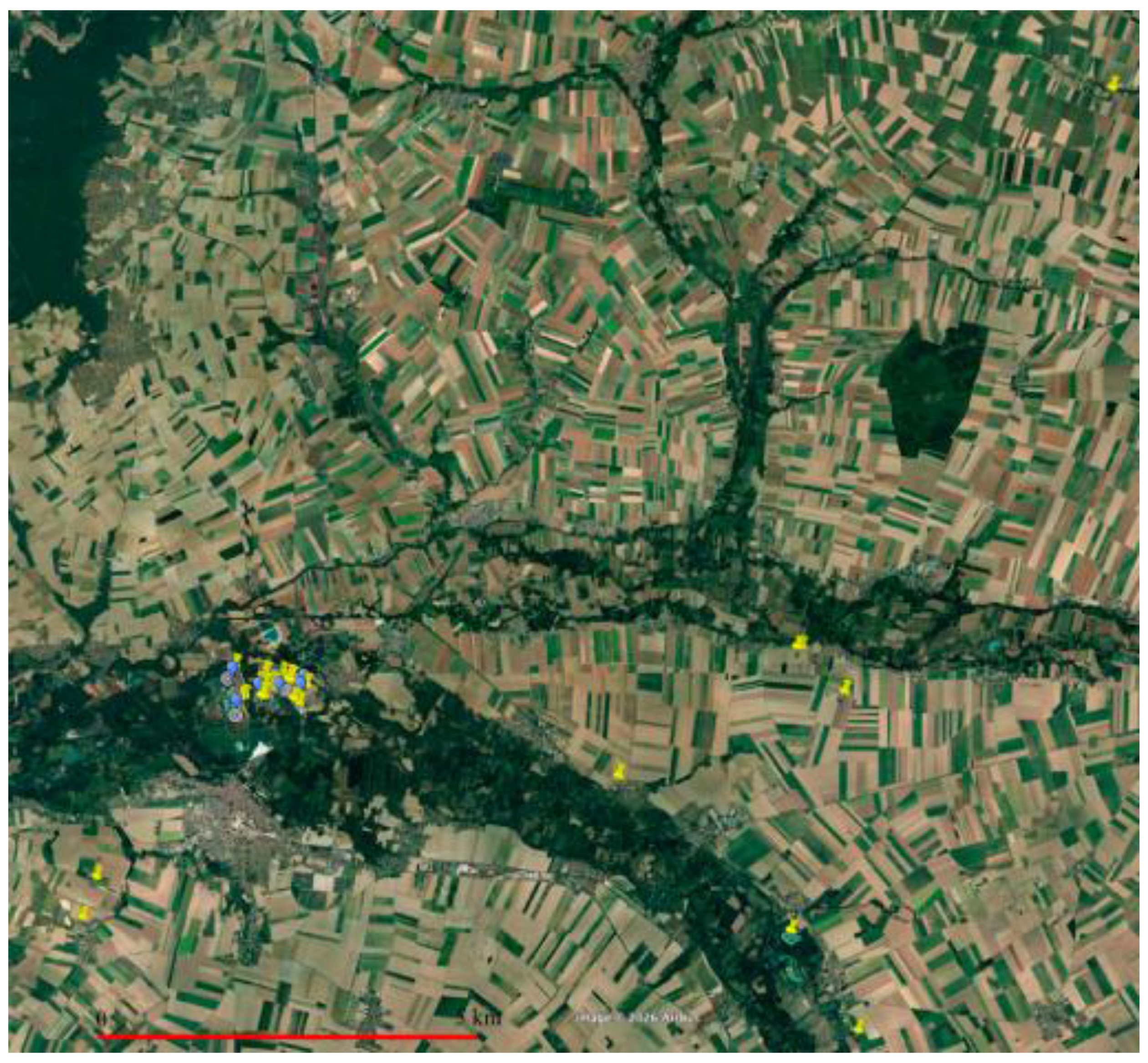
Figure 4.
Quaternary deformations. Point 1 (Marcilly and Sauvage) corresponds to the alluvial deformations in the Seine valley. Points 19 (Gourgançon) and 20 (Longueville) are documented evidence of neotectonics. Point 6 corresponds to the chalk quarry at Charny-le-Bachot.
Figure 4.
Quaternary deformations. Point 1 (Marcilly and Sauvage) corresponds to the alluvial deformations in the Seine valley. Points 19 (Gourgançon) and 20 (Longueville) are documented evidence of neotectonics. Point 6 corresponds to the chalk quarry at Charny-le-Bachot.
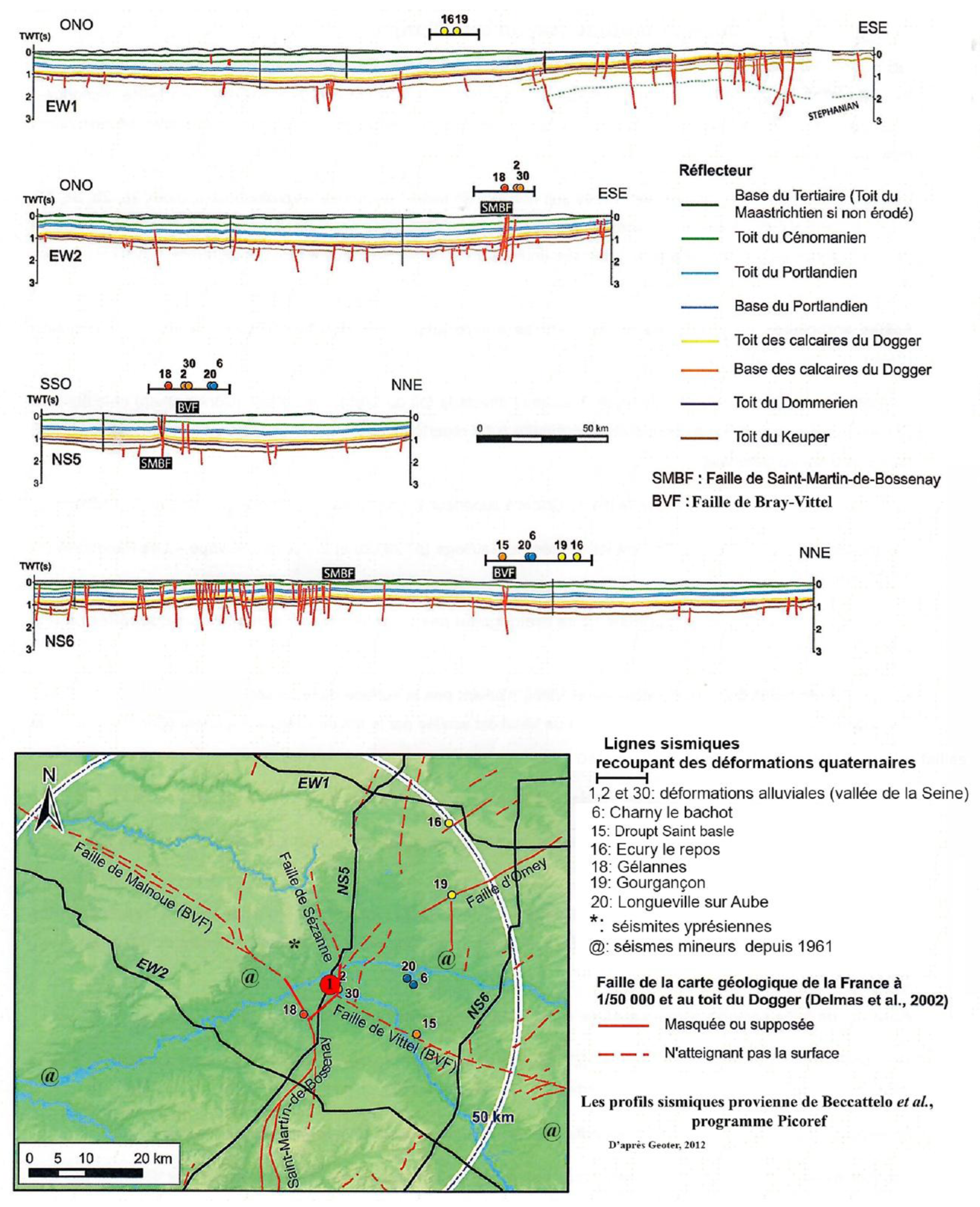
Figure 7.
Overlapping fault (Charny-le-Bachot). The vertical photograph shows a reverse fault overlapping a palaeosol.
Figure 7.
Overlapping fault (Charny-le-Bachot). The vertical photograph shows a reverse fault overlapping a palaeosol.
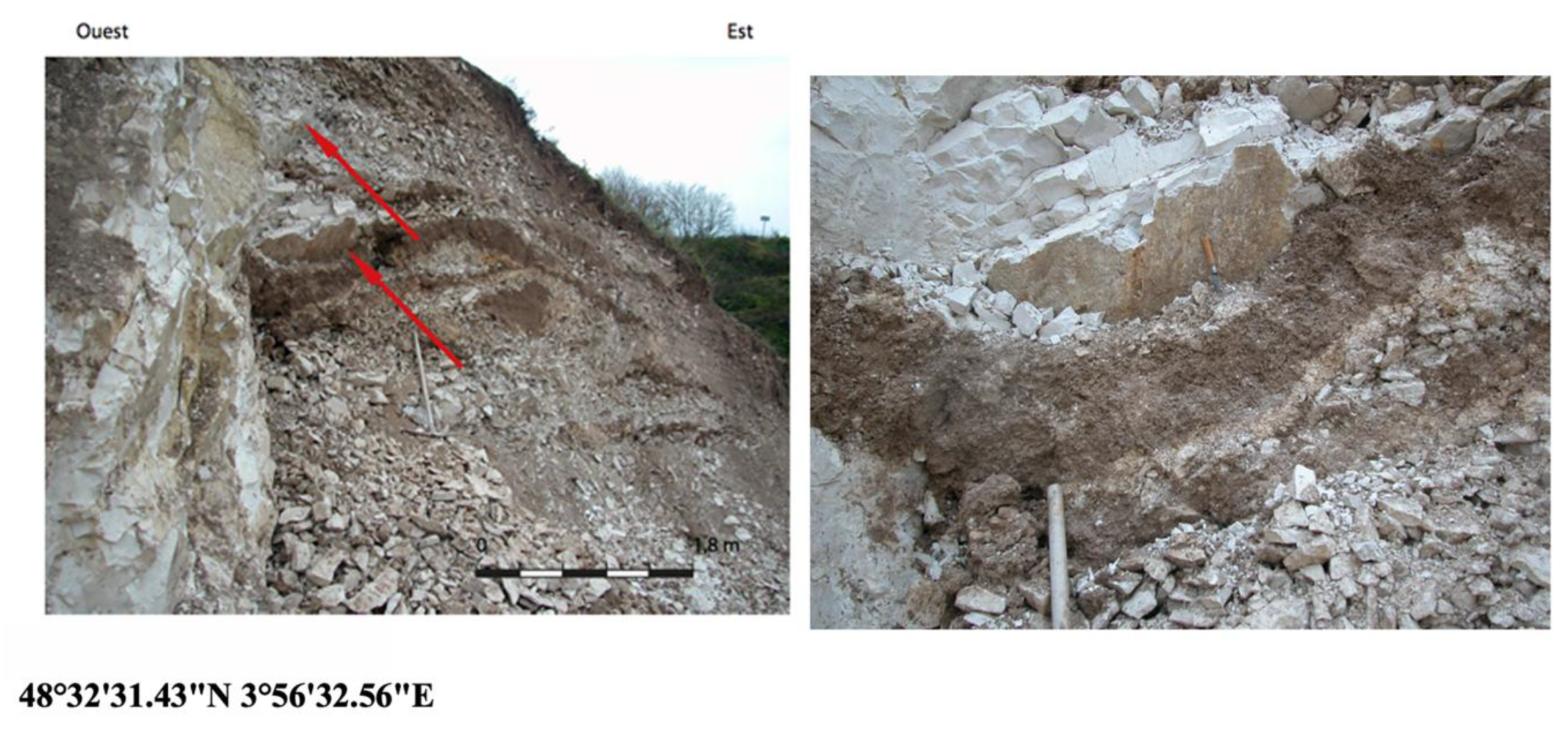
Figure 8.
Load cast. The gravel forms a lobe that extends into the silt. A small, centimetre-wide fault can be seen on the right, above the brush.
Figure 8.
Load cast. The gravel forms a lobe that extends into the silt. A small, centimetre-wide fault can be seen on the right, above the brush.
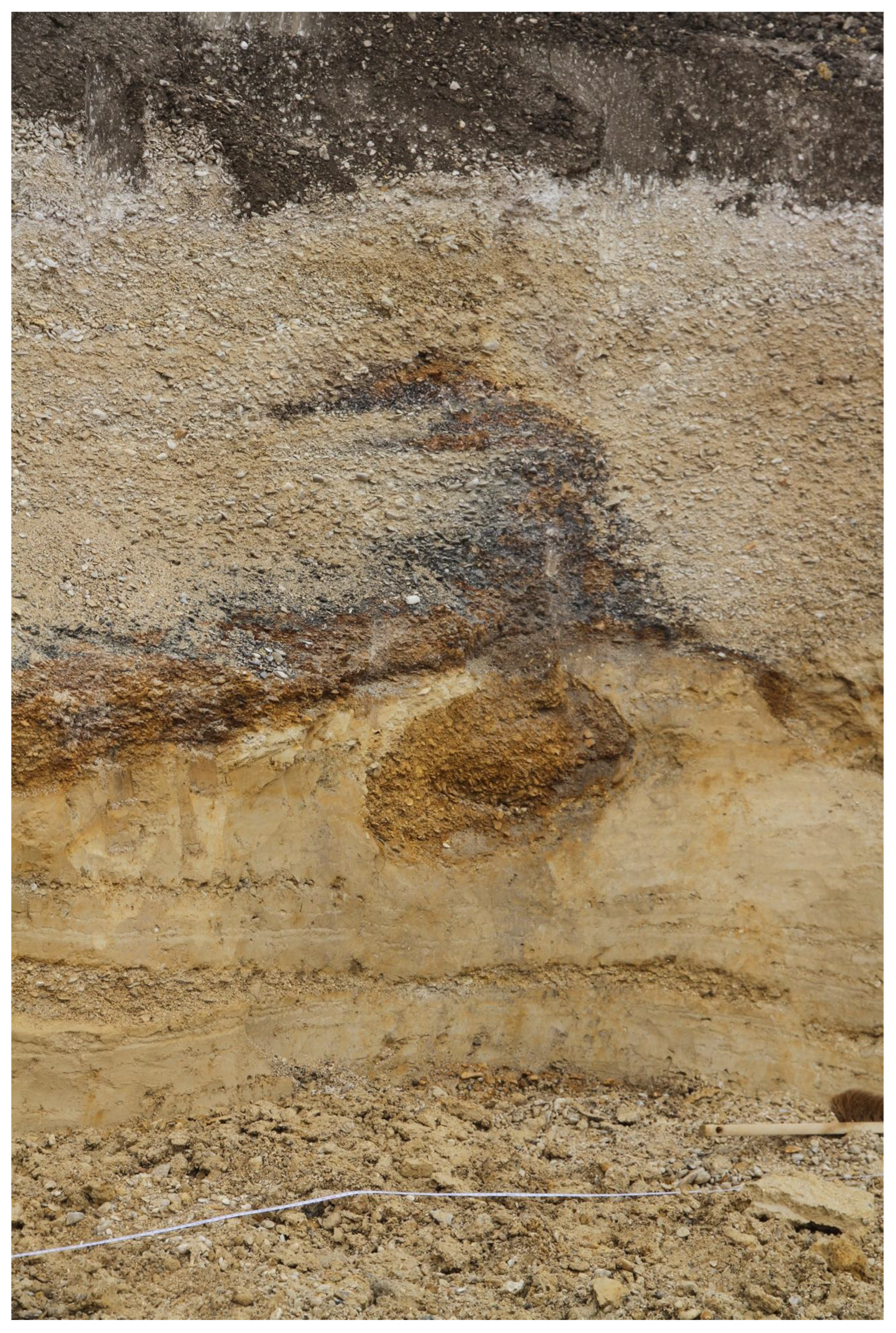
Figure 9.
Flame-like structure rising to the surface. This type of structure can form during earthquakes of magnitude 6 or greater. The pickaxe serves as a scale.
Figure 9.
Flame-like structure rising to the surface. This type of structure can form during earthquakes of magnitude 6 or greater. The pickaxe serves as a scale.

Figure 10.
Gravity landslide. The Holocene soil is affected, top right (red arrow).
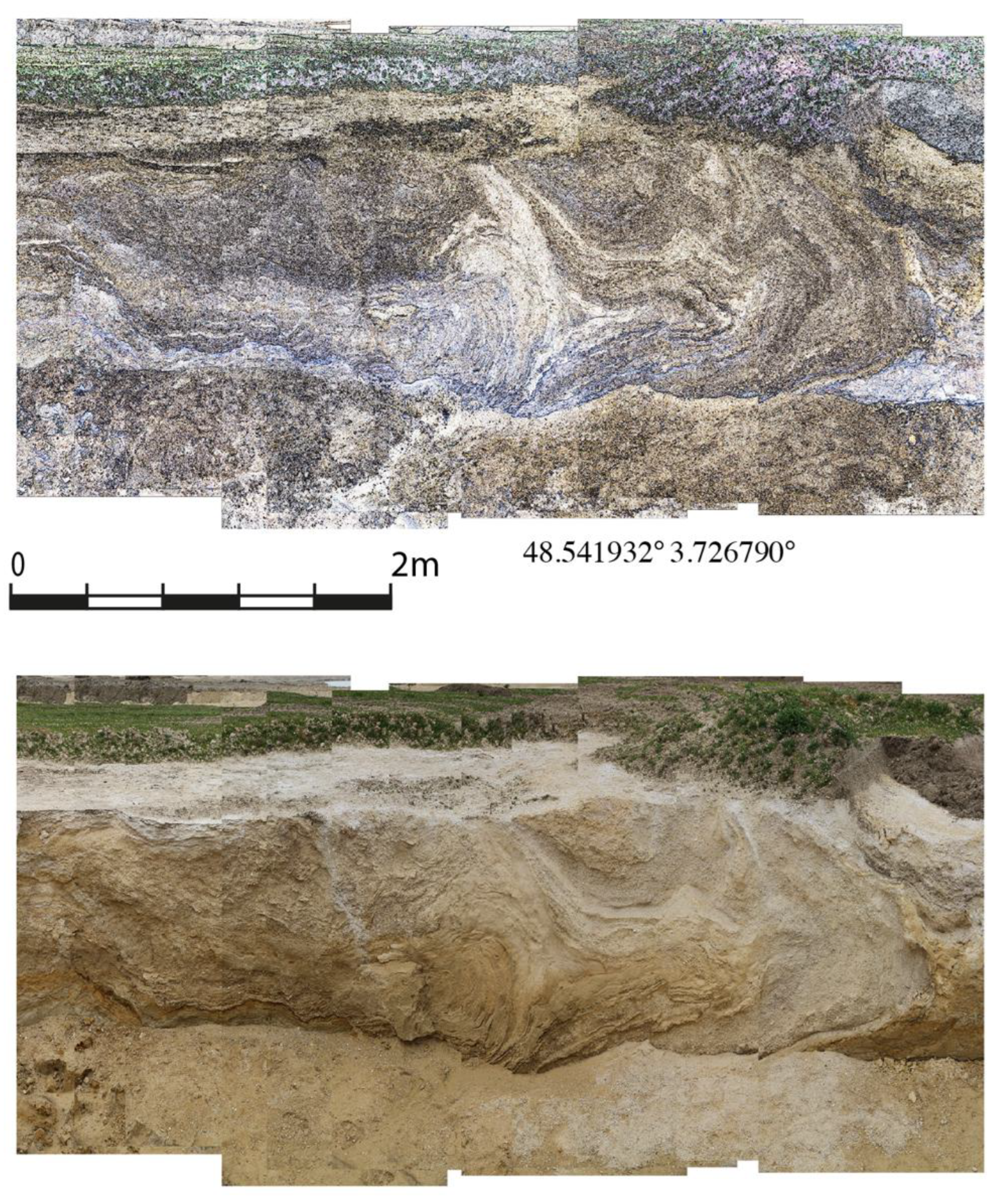
Figure 11.
Faulted and folded anticline with summit folds. The section is 1.9 m long.
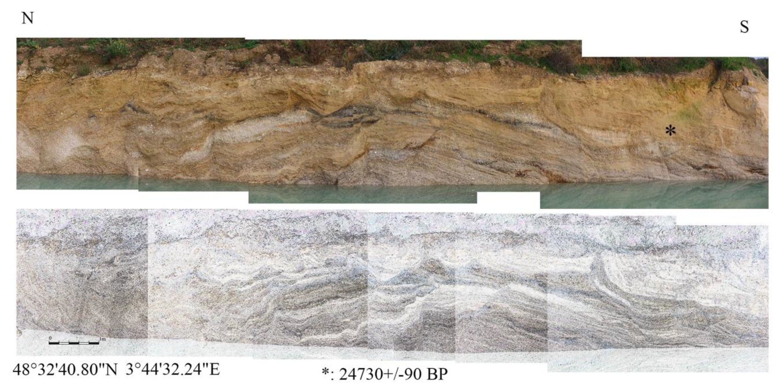
Figure 12.
Fracturing at the top of the sand layer. The sculpture is 1.8 metres tall.
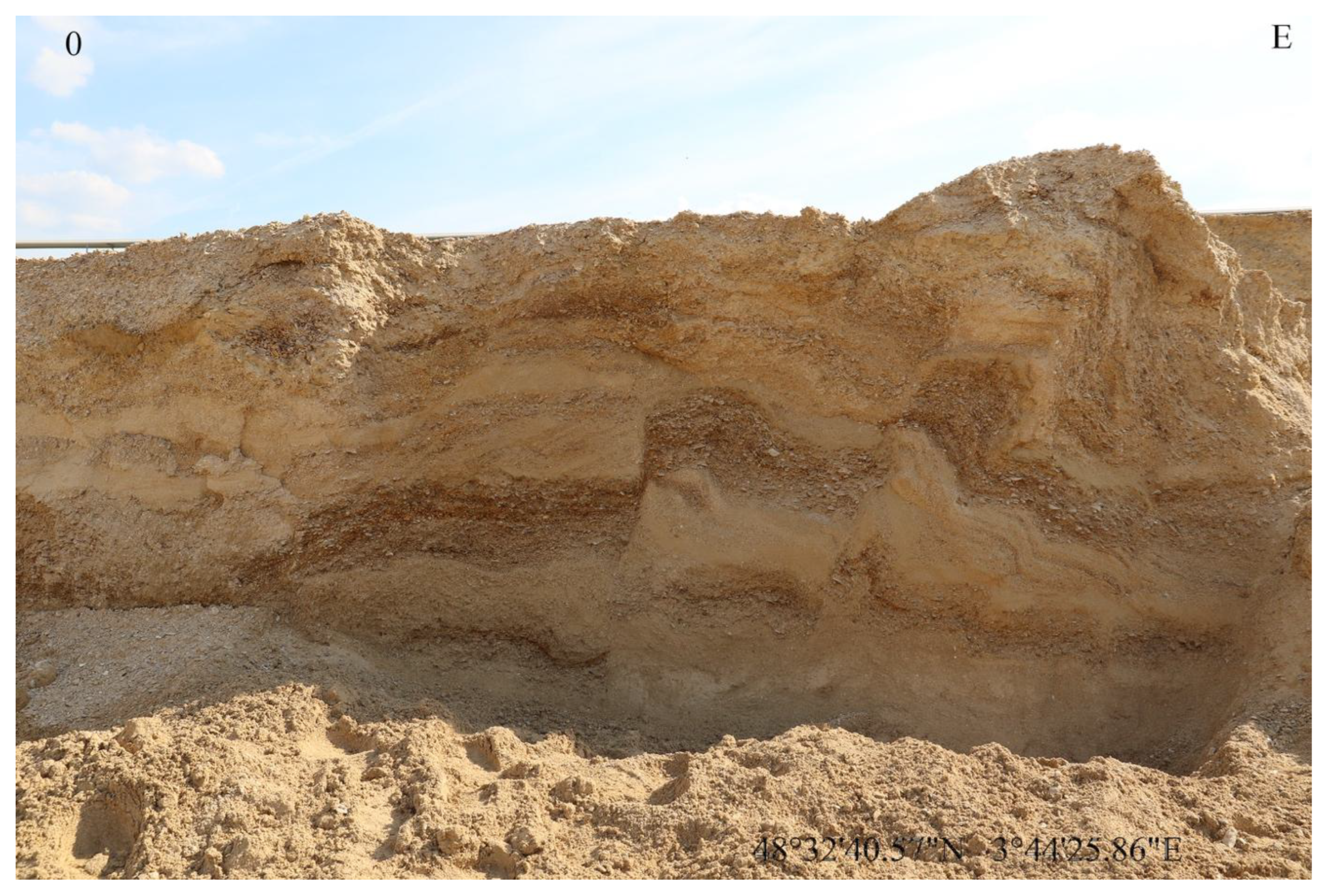
Figure 17.
A fault with an inverse appearance. The section is 1.8 m long.
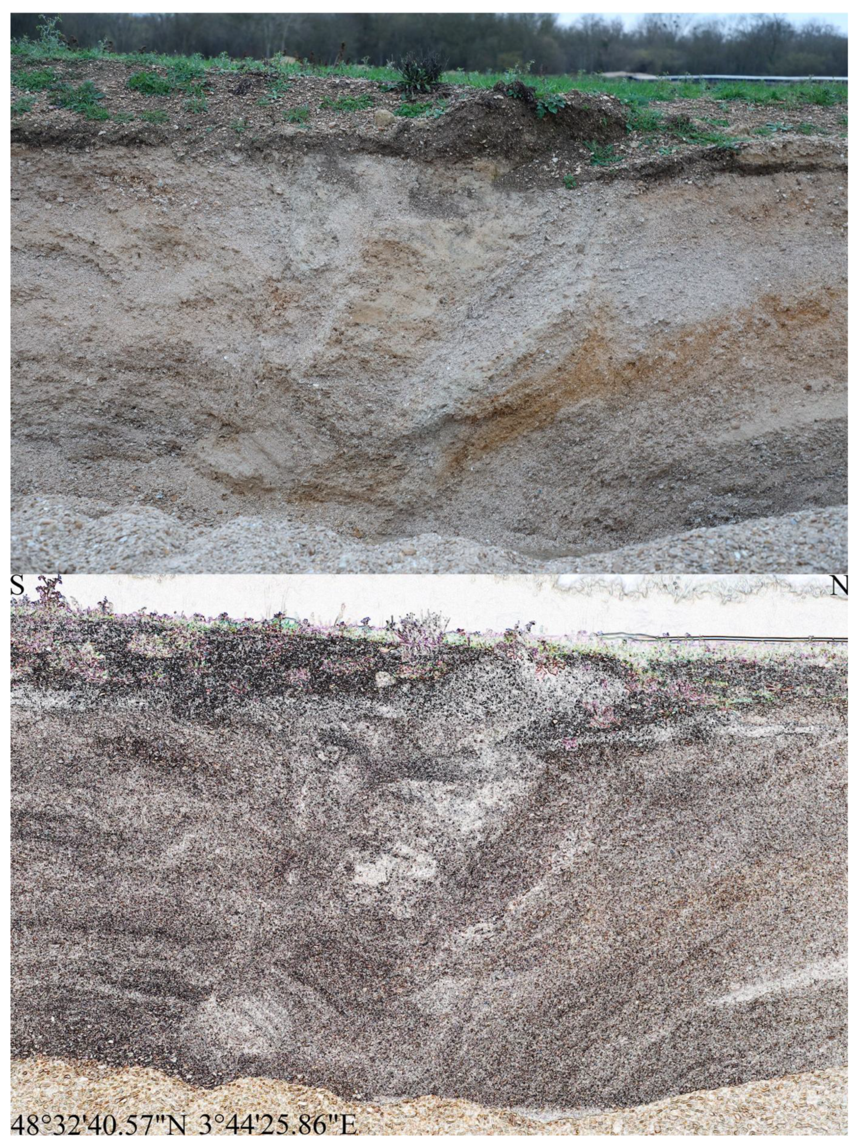
Figure 20.
Distribution of tephra from Laacher See (12,900 BP).
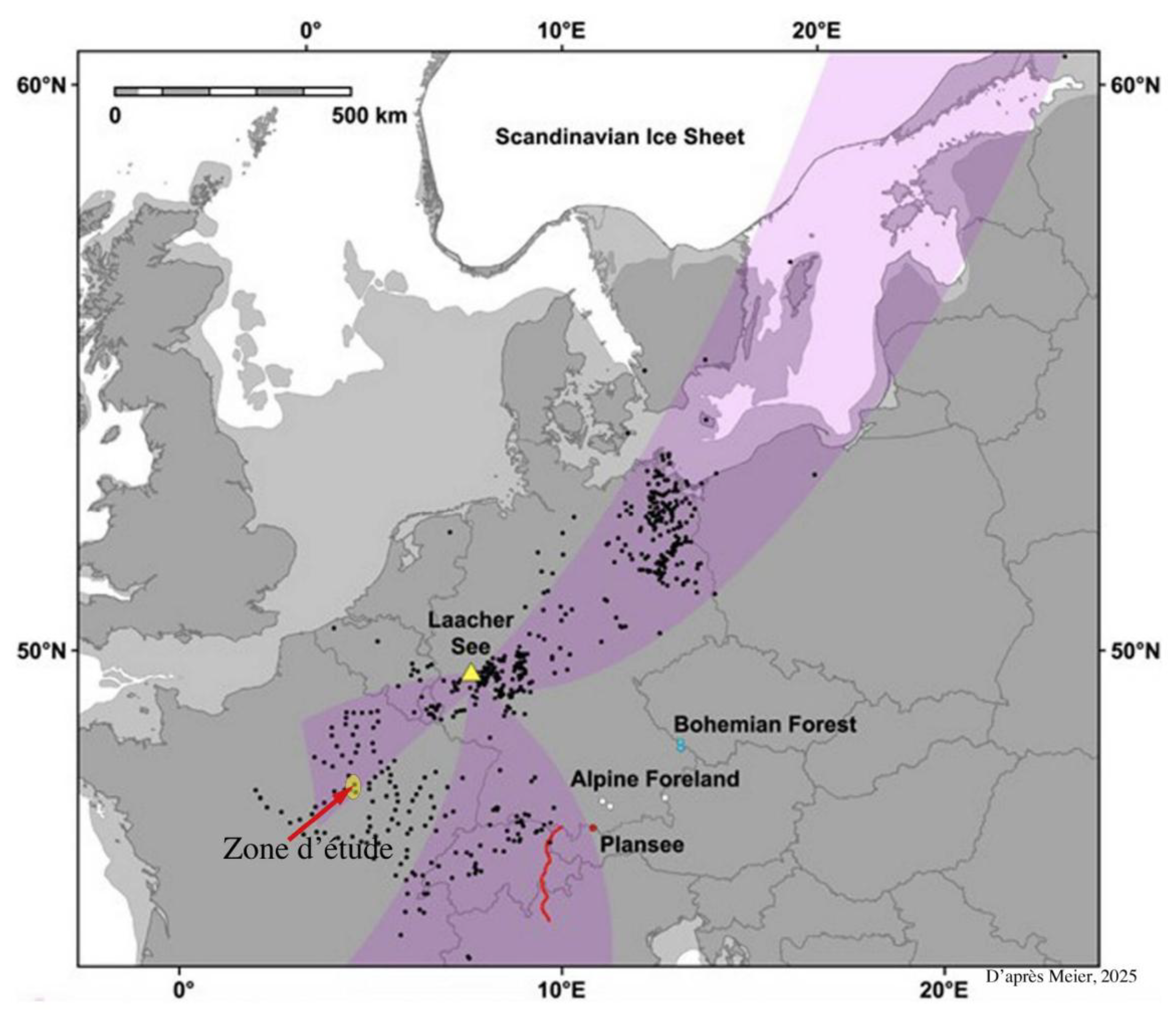
Figure 21.
Reactivated faults.
Disclaimer/Publisher’s Note: The statements, opinions and data contained in all publications are solely those of the individual author(s) and contributor(s) and not of MDPI and/or the editor(s). MDPI and/or the editor(s) disclaim responsibility for any injury to people or property resulting from any ideas, methods, instructions or products referred to in the content. |
© 2026 by the author. Licensee MDPI, Basel, Switzerland. This article is an open access article distributed under the terms and conditions of the Creative Commons Attribution (CC BY) license.
Copyright: This open access article is published under a Creative Commons CC BY 4.0 license, which permit the free download, distribution, and reuse, provided that the author and preprint are cited in any reuse.