

Submitted:
15 August 2026
Posted:
18 August 2026
You are already at the latest version
Abstract
Accurate road graph extraction from satellite imagery is essential for large-scale mapping and geospatial analysis. Recent one-shot graph extraction frameworks based on foundation models have achieved promising performance, but their effectiveness decreases in complex environments where road structures are partially obscured by vegetation, buildings, shadows, and other surface conditions. These occlusion-induced disturbances lead to incomplete connectivity and degraded topology reconstruction, particularly under out-of-domain scenarios. This study proposes an occlusion-aware refinement framework to improve the robustness of satellite image road graph extraction while maintaining the original backbone architecture. The proposed framework introduces three complementary strategies: synthetic occlusion augmentation for explicit occlusion-aware representation learning, an occlusion-adaptive extended-line strategy with hard-mining topology optimization for improved connectivity reasoning, and an occlusion-adaptive node-guided resampling mechanism for reliable graph node localization. Experiments conducted on the Global-Scale road graph extraction benchmark demonstrate that the proposed method consistently improves topology reconstruction performance. Compared with the reproduced SAM-Road++ baseline, the proposed framework improves TOPO F1 from 61.81 to 62.56 on the in-domain split and from 46.93 to 51.51 on the out-of-domain split. Furthermore, the ID-OOD performance gap is reduced from 14.88 to 11.05, indicating enhanced robustness under unseen geographic conditions. The results demonstrate that explicitly modeling occlusion as a structured factor can effectively improve the generalization capability of satellite road graph extraction systems.
Keywords:
remote sensing image analysis
; road graph extraction
; occlusion-aware learning
; out-of-domain generalization
; connectivity prediction
1. Introduction
Road graph extraction from satellite imagery has become an important task for remote sensing because many downstream applications require not only road pixels but also usable network structure. High-definition map updating for autonomous driving depends on accurate connectivity, disaster response requires rapid assessment of accessible routes, and navigation systems benefit from road graphs that preserve intersections, branches, and missing links. In this sense, road graph extraction is a step beyond conventional road segmentation. Segmentation estimates where roads appear, but graph extraction asks how road segments connect, which roads are interrupted, and where topology should be completed. This difference matters especially in large-scale remote sensing scenes, where road visibility changes rapidly across cities, rural regions, mountains, shadows, and tree cover. A method that performs well as a pixel classifier may still produce broken or fragmented graphs when the scene becomes complex. For this reason, topology-aware road extraction has emerged as a younger but increasingly important subfield in remote sensing.
Recent one-shot paradigms have pushed this direction forward by turning road graph extraction into a prompt-based inference problem [1]. Among them, SAM-Road++ is a particularly strong baseline on the Global-Scale benchmark because it combines road segmentation and node connectivity prediction in a single framework. Its node-guided resampling reduces the mismatch between training and inference, while its extended-line strategy attempts to bridge local gaps caused by partial occlusion. These design choices make SAM-Road++ a natural reference point for further progress. At the same time, the Global-Scale benchmark also reveals that its robustness is far from complete. According to the reported results, SAM-Road++ achieves a TOPO [2] F1 score of 62.33 on the in-domain test set but drops to 48.34 on the out-of-domain set that includes Hong Kong, Shenzhen, and Lucerne. This gap is not a minor fluctuation. It shows that even a strong one-shot method still struggles when road appearance, scene layout, and occlusion pattern shift together. While domain shift contributes to the decline, the dominant factor is the stronger occlusion severity in rural and mountainous tiles, where tree canopies and building shadows interrupt road continuity more aggressively. In other words, the benchmark does not merely expose a generalization problem. It exposes a specific weakness in how current methods handle occlusion under unseen scene conditions.
A closer inspection of SAM-Road++ also reveals three concrete limitations that explain why this weakness persists. First, the extended-line module samples points along a fixed 8-pixel extension with uniform spacing. This design implicitly assumes that occlusion is mild and that the road direction remains approximately linear over the sampled segment. Such an assumption works for short and simple breaks, but it becomes fragile when tree crowns cover longer portions of the road or when the gap is not aligned with a straight continuation. Second, node-guided resampling locates road nodes by calling find_highest_mask_point inside a fixed 2-pixel neighborhood. This local search is efficient, but it is too narrow when the predicted mask peak is displaced by a large occlusion, a shadow boundary, or a discontinuous response in the mask decoder. In that case, the snap operation may lock onto an incorrect position or fail to recover the missing node entirely. Third, the model is never explicitly trained on controllable and progressive occlusion. It only sees standard training samples, so any robustness to occlusion degree is learned implicitly and incidentally. This makes the model dependent on chance exposure rather than on a stable supervisory signal. Together, these three points show that the current pipeline is still built around a weak prior: occlusion is treated as a local and mostly linear perturbation, rather than as a structured and controllable condition that should be learned during training.
To address these limitations, we introduce an occlusion-aware refinement of the SAM-Road++ pipeline that keeps the backbone intact and only changes the data flow, forward logic, and loss design. The first component is Synthetic Occlusion Augmentation, or OccAug. We inject controllable pseudo-occlusions into RGB training patches after rotation and before model input, while keeping the ground-truth labels unchanged. The goal is not to simulate every real-world occluder perfectly, but to expose the model to a progressive occlusion signal that makes the learning process aware of road interruption patterns. By using different occlusion modes, such as cutout-like masks or Perlin-style irregular covers, the training set becomes richer in topology-breaking cases without requiring additional annotation. The second component is an Occlusion-Adaptive Extended-Line strategy with a hard-mining topology loss. Instead of sampling along a fixed 8-pixel line, we adapt the extension range according to online mask confidence, so the model can probe farther when the local prediction is uncertain and stay conservative when the evidence is strong. The same confidence signal is then reused to weight hard pairs in the topology loss, especially those that are connected in ground truth but appear weak or incomplete in the predicted mask. This design turns occlusion from a static nuisance into an informative signal for learning harder connectivity cases. The third component is Occlusion-Adaptive Node-Guided Resampling. Rather than restricting the search to a fixed 2-pixel radius, we adopt a coarse-to-fine strategy that expands the search region when the peak confidence is insufficient and falls back to the original coordinate only when the response remains ambiguous. This simple change makes node snapping more resilient to larger or discontinuous occlusions, while preserving the efficiency of the original mechanism. Importantly, all three components are local modifications. They can be implemented within the existing dataset pipeline and model forward or loss computation, without altering the SAM backbone [3,4] structure.
These changes lead to a consistent training and inference story. OccAug teaches the model what controlled occlusion looks like. The adaptive extended-line module uses uncertainty to bridge likely gaps more carefully. The adaptive node-guided resampling module improves alignment when the predicted node location shifts under heavy occlusion. Together, they target the three failure modes revealed by Global-Scale in a way that is simple, direct, and compatible with the original architecture. In addition, we include an out-of-domain threshold recalibration analysis as a training-free complement. Using the existing threshold search procedure, we recalibrate inference thresholds on the OOD tiles separately from the validation-derived default setting. This analysis does not claim to solve domain adaptation. Rather, it provides a lightweight engineering check that clarifies how much of the OOD drop can be recovered without further training. Such a supplement is useful for practical deployment and also improves reproducibility.
The contributions of this work are fourfold. First, we propose OccAug, which introduces controllable occlusion supervision into graph-level road extraction rather than only into segmentation-level augmentation. Second, we develop an occlusion-adaptive extended-line strategy together with a hard-mining topology loss, extending fixed linear sampling into confidence-driven adaptive sampling for difficult connectivity cases. Third, we design an occlusion-adaptive node-guided resampling scheme that replaces the fixed small-radius snap with a coarse-to-fine search, improving node alignment under larger or discontinuous occlusions. Fourth, we validate the proposed method on Global-Scale, including 130 out-of-domain tiles, showing that the proposed refinements narrow the in-domain and out-of-domain performance gap while remaining compatible with the original SAM-Road++ framework. Overall, this paper argues that robust road graph extraction in remote sensing should not depend on accidental exposure to occlusion. Instead, occlusion should be modeled as an explicit training condition, an adaptive inference cue, and a topology-specific learning challenge. This perspective enables more stable road connectivity prediction across scenes, domains, and visibility conditions.
2. Related Work
2.1. Pixel-Wise Road Segmentation
Road extraction from remote sensing imagery has traditionally been formulated as a pixel-wise segmentation problem, where each pixel is classified as road or non-road [5]. Early deep learning approaches mainly adopted fully convolutional architectures, such as U-Net [6] and its variants, to learn dense road representations from satellite images. Building upon this paradigm, DeepRoadMapper [7] introduced a specialized road mapping framework that combined semantic segmentation with additional structural constraints, while orientation-aware segmentation methods further incorporated directional information to improve the representation of elongated road structures. More powerful segmentation architectures, including D-LinkNet [8] and other encoder-decoder networks [2], have also achieved strong performance on several benchmark datasets by improving feature extraction and contextual modeling. Recently, Transformer-based segmentation architectures such as SegFormer [9] have emerged as stronger backbones for pixel-wise road segmentation, achieving remarkable mIoU with lightweight MLP decoders.
Although pixel-wise segmentation methods have become relatively mature, their formulation fundamentally differs from the requirements of road graph extraction. Since each pixel is predicted independently, these methods lack explicit modeling of connectivity relationships between road segments. Consequently, small prediction errors may accumulate during vectorization, producing disconnected fragments, missing intersections, or incorrect connections. This limitation becomes more significant in complex remote sensing scenarios where roads are partially hidden by tree canopies, building shadows, or other objects. A segmentation model may recover visually complete road regions while still failing to produce a reliable road network. Therefore, pixel-level methods provide valuable road appearance information but remain insufficient for applications that require accurate topology and graph structure.
This limitation has motivated the transition from pixel prediction toward graph-level road extraction, where the objective is not only to identify road locations but also to infer the underlying connectivity structure [5].
2.2. Graph-Level Road Extraction
Graph-level road extraction methods aim to directly reconstruct road networks by predicting vertices, edges, or graph structures from remote sensing imagery. Existing approaches can generally be categorized into two major paradigms: iterative graph-growing methods and global graph-generating methods.
Iterative graph-growing methods, represented by RoadTracer [10], RNGDet [11], and RNGDet++ [12], construct road graphs progressively from initial seed points. These methods predict the next vertex or edge based on previously generated structures, enabling detailed local reasoning around intersections and road branches. RNGDet and RNGDet++ further improve this paradigm by introducing stronger visual representations and additional supervision to enhance graph completeness. The main advantage of graph-growing methods is their ability to preserve local topological consistency. However, because inference depends on sequential expansion, prediction errors can accumulate along long trajectories. In addition, repeated local decisions introduce considerable computational overhead, limiting scalability for large-area satellite imagery.
To overcome these limitations, global graph-generating methods have emerged as a more efficient alternative. Sat2Graph [13] represents an important transition by transforming road extraction into a global graph prediction problem. Instead of iteratively expanding the graph, it predicts graph-related representations from the entire image and reconstructs road connectivity in a unified manner. Following this direction, SAM-Road [14] adapts the Segment Anything Model framework for road graph extraction by combining road mask prediction and keypoint-based graph generation. SAM-Road++ [15] further improves this framework by introducing node-guided resampling and extended-line strategies. Node-guided resampling reduces the mismatch between training-time node prediction and inference-time graph construction, while extended-line sampling provides additional evidence for connecting locally interrupted road segments. Due to these improvements, SAM-Road++ achieves strong performance on the Global-Scale benchmark and remains one of the most competitive baselines for large-scale road graph extraction.
Recent studies continue to explore more advanced graph construction strategies. DeH4R [16] proposes a decoupled and hybrid framework that combines global graph generation with local graph expansion, attempting to balance efficiency and structural refinement. GLD-Road [17] introduces a global-local decoding strategy, where global queries generate initial road nodes and local refinement recovers missing structures. LineGraph2Road [18] focuses on link-level reasoning by converting edge prediction into a line graph formulation, enabling stronger relational modeling between candidate connections. DOGE [19] further formulates road graph construction as differentiable Bezier graph optimization, improving geometric flexibility of edge representation. MaGRoad [20] introduces a path-centric representation instead of relying solely on node features, extracting multi-scale evidence along candidate road paths to improve structural prediction under challenging scenes. These methods demonstrate continuous progress in graph representation, decoding efficiency, and topology reasoning.
Despite these advances, current graph extraction methods mainly focus on improving graph construction mechanisms, feature representation, or inference efficiency. Occlusion is usually treated as an implicit visual disturbance rather than an explicit learning condition. Even strong global methods, including SAM-Road++, still rely on fixed sampling strategies and locally constrained node alignment mechanisms, which limits their ability to recover topology when roads experience severe or irregular occlusion. This observation motivates a different perspective: instead of only designing better graph decoders, occlusion itself should be modeled as a controllable factor during graph learning.
The Global-Scale dataset further provides a valuable foundation for evaluating such robustness. Beyond benchmarking road extraction algorithms, it has also been adopted by downstream studies such as PathPainter [21] to examine the generalization capability of generated navigation priors under out-of-domain conditions. This demonstrates that Global-Scale is not only a road mapping benchmark but also an important evaluation platform for assessing whether extracted road graphs remain reliable across diverse geographic environments.
2.3. Occlusion Handling in Remote Sensing Road Extraction
Occlusion is one of the major factors affecting road extraction performance because satellite images frequently contain incomplete visual evidence caused by vegetation, buildings, shadows, and terrain variation. Existing studies have investigated occlusion mainly from the perspective of semantic segmentation. For example, RCFSNet [22] introduces multi-scale context extraction, full-stage feature fusion, and attention-based feature enhancement to recover road regions under complex occlusion conditions. Other approaches, such as CIFNet [23], further improve contextual reasoning and continuity preservation by strengthening global-local feature interaction or road-specific representation learning.
Although these methods improve the completeness of predicted road masks, their optimization objectives remain centered on pixel-level accuracy. The final road topology still depends on subsequent vectorization or graph reconstruction procedures, where occlusion-induced errors can appear as incorrect node positions, missing edges, or broken connectivity. Therefore, segmentation-level occlusion handling does not directly solve the challenges faced by graph extraction systems.
Meanwhile, existing graph-based road extraction methods generally benefit from stronger architectures and improved decoding strategies, but they do not explicitly introduce occlusion-aware learning mechanisms. To the best of our knowledge, no previous global graph extraction framework has jointly considered controllable occlusion augmentation, occlusion-adaptive node alignment, and occlusion-aware connectivity learning. This indicates that occlusion robustness at the graph topology level remains insufficiently explored.
2.4. Domain Shift and Out-of-Domain Evaluation
Large-scale remote sensing applications inevitably encounter domain variations caused by differences in geographic regions, urban structures, imaging conditions, and environmental characteristics. Recent benchmarks such as Global-Scale provide out-of-domain evaluation settings to measure whether road extraction methods can generalize beyond their training distributions. Results from these benchmarks reveal that even advanced graph extraction methods experience performance degradation when transferred to unseen regions with different landscape patterns and occlusion characteristics.
However, improving out-of-domain performance is not equivalent to solving domain adaptation. Domain adaptation methods typically aim to learn domain-invariant representations through additional training strategies or cross-domain supervision. In contrast, this work does not claim to address complete domain adaptation [24]. The proposed threshold recalibration analysis is only used as a training-free engineering complement to examine how much performance variation can be recovered through inference-time adjustment. The primary contribution remains improving the intrinsic robustness of graph extraction under occlusion through explicit augmentation and adaptive topology modeling.
Overall, existing research has successfully advanced road extraction from pixel-level segmentation toward graph-level topology reconstruction. Nevertheless, current methods still lack explicit mechanisms for learning and handling occlusion-induced topology degradation. Addressing this limitation is essential for building reliable road graphs in large-scale and diverse remote sensing environments. This work therefore focuses on occlusion-aware topology learning as a complementary direction to existing graph extraction frameworks.
3. Methodology
3.1. Overview of the Proposed Framework
The proposed framework aims to improve the robustness of satellite image road graph extraction under severe occlusion conditions while maintaining the original efficiency and scalability of the SAM-Road++ architecture. Instead of modifying the fundamental structure of the SAM backbone, we introduce three occlusion-aware improvements into different stages of the existing pipeline, including Synthetic Occlusion Augmentation (OccAug), Occlusion-Adaptive Extended-Line with Hard-Mining Topology Learning, and Occlusion-Adaptive Node-Guided Resampling. The overall framework is illustrated in Figure 1.
Given an input satellite image patch, the framework first extracts dense visual representations through the SAM image encoder. The extracted features are then processed by the mask decoder to generate spatial predictions for road regions and keypoints. These predictions provide geometric guidance for graph node generation and topology reasoning. The node features and pairwise connection features are subsequently constructed and fed into TopoNet [25] for road graph prediction.
Different from the original SAM-Road++ pipeline, the proposed method introduces explicit occlusion modeling into the training and inference process. OccAug modifies only the RGB input during training while preserving the original annotations. The adaptive extended-line module improves topology reasoning by replacing fixed-length sampling with confidence-guided feature aggregation. The adaptive node-guided resampling module improves node localization by dynamically adjusting the search range according to prediction reliability. The positions of the three proposed components are highlighted in Figure 1.
For an input image:
where and represent the image height and width, the SAM encoder extracts visual features:
where denotes the image embedding feature. In our implementation, the input resolution is 512×512 pixels, and the SAM ViT encoder produces a feature representation with spatial downsampling. The tensor transformation process from image input to topology prediction is summarized in Table 1.
The feature representation is further processed by the mask decoder:
where contains two prediction channels corresponding to keypoint and road probability estimation. The probability maps are obtained as:
where represents the sigmoid activation function.
The predicted road graph is represented as:
where denotes road nodes and denotes road connections. Each node is represented as:
where is the number of detected nodes.
The node features are sampled from the encoded feature map according to their spatial coordinates. For each node pair, TopoNet constructs a relational feature representation by combining node information and line-level contextual features. The final connectivity probability is predicted as:
where indicates the probability that two nodes are connected.
Table 1 presents the tensor flow of the proposed framework. It provides the feature dimensions of each processing stage and ensures consistency between the proposed methodology and implementation. The detailed data flow from image input through the SAM encoder, mask decoder, adaptive node snapping, and topology prediction is visualized in Figure 2.
The overall training objective combines spatial prediction and topology optimization:
where supervises road and keypoint prediction, and optimizes graph connectivity.
3.2. Synthetic Occlusion Augmentation
Occlusion is one of the primary factors that causes topology degradation in satellite image road graph extraction. Existing augmentation methods mainly focus on geometric transformation or color variation, which improves general visual robustness but does not provide explicit supervision for missing road structures caused by vegetation, shadows, or other objects [26]. To address this limitation, we introduce Synthetic Occlusion Augmentation (OccAug), which generates controllable pseudo-occlusion patterns during training [27,28].
The key principle of OccAug is annotation preservation. The augmentation operation modifies only the RGB image, while the road mask, keypoint annotation, and graph structure remain unchanged. Therefore, the model learns to reconstruct complete road topology from incomplete visual evidence.
OccAug is implemented in the dataset pipeline after rotation augmentation and before image normalization. Specifically, the augmentation is activated only during the training stage. Three configurable parameters are introduced, including augmentation switch, probability, and occlusion mode, allowing flexible control of the training strategy.
The augmented image is defined as:
where represents the occlusion transformation and represents the probability of applying OccAug.
Two occlusion patterns are implemented to simulate different visibility degradation conditions. The first pattern is cutout-based occlusion, which models compact obstacles such as building shadows and dense vegetation regions. Given a randomly generated rectangular region:
the corrupted region is generated as:
where controls the occlusion intensity and denotes the filling color.
The second pattern generates irregular occlusion regions. Instead of using predefined geometric masks, random noise is first generated and then smoothed through Gaussian filtering. The binary occlusion mask is obtained by thresholding:
where represents the random noise field, represents Gaussian smoothing, and is the threshold parameter.
The final irregular occlusion is applied as:
Compared with random erasing, this strategy provides more realistic irregular boundaries while remaining computationally efficient.
Since the graph annotation remains unchanged, the learning objective becomes:
where denotes the original ground-truth annotation.
By introducing controllable occlusion during training, OccAug converts occlusion from an unexpected disturbance into an explicit learning condition. The model can therefore learn topology completion ability under various visibility degradation levels.
3.3. Occlusion-Adaptive Extended-Line and Hard-Mining Topology Learning
The extended-line mechanism in SAM-Road++ provides additional contextual information for topology prediction by sampling features beyond the direct connection between two nodes. Although this strategy improves the recovery of locally interrupted roads, its fixed extension length and uniform sampling pattern introduce a strong prior that occlusion gaps are short and approximately linear. Such an assumption is insufficient for remote sensing scenes containing large tree canopies, irregular shadows, or complex background interference.
To overcome this limitation, we propose an Occlusion-Adaptive Extended-Line strategy, which dynamically adjusts the sampling range according to the local road confidence. The main idea is to use the predicted road probability as an uncertainty indicator. When the intermediate region between two nodes contains reliable road evidence, local line features are sufficient. When the predicted response becomes weak, the model automatically explores a larger spatial context to search for possible hidden connectivity.
As illustrated in Figure 3, given two candidate nodes and , the normalized direction vector is first calculated as:
where is a small constant for numerical stability. Based on this direction, the short extended line follows the original SAM-Road++ sampling strategy:
where epresents the short extension distance and is set according to the original implementation.
To estimate whether additional contextual information is required, we introduce an occlusion confidence score. Twenty sampling points are uniformly generated between the two nodes, and three local feature responses are extracted from each point. The intermediate confidence is calculated as:
where denotes the sampled position and represents the predicted road probability map. A lower indicates weaker road evidence and a higher possibility of occlusion-induced topology interruption.
According to this confidence, a long-range line feature is adaptively introduced. The long extension endpoints are calculated as:
where . The short-range and long-range line features are extracted separately:
The adaptive fusion coefficient is obtained through:
where is the confidence threshold and controls the transition sharpness. The final line representation is defined as:
When the road confidence is high, approaches zero and the model mainly relies on local evidence. When the road response decreases because of occlusion, increases and introduces larger contextual information.
In addition to adaptive feature sampling, we further redesign the topology optimization objective [29,30]. Conventional binary cross-entropy topology loss treats all node pairs equally, although different connections have substantially different difficulty levels [31,32]. In particular, positive road connections interrupted by occlusion are more challenging than directly visible road segments. Therefore, we introduce a hard-mining weighting strategy guided by the same confidence measurement.
The normalized hardness score is defined as:
where estricts the value into the range of zero to one. The topology weight is formulated as:
where \( A_{ij}\) represents the ground-truth connectivity label and \( \alpha\) controls the maximum mining strength. Since \( h_{ij}\) is normalized, the maximum weighting factor is \( 1+\alpha\) , preventing unstable gradient amplification.
The final topology loss becomes:
where emoves invalid padded node pairs and represents all candidate node connections.
This design enables the topology network to focus on difficult occluded connections while maintaining normal optimization behavior for clear road structures. Different from manually increasing the receptive field, the proposed strategy allows the model to determine when additional context is required according to the current prediction uncertainty.
3.4. Occlusion-Adaptive Node-Guided Resampling
Node localization is a critical step in graph extraction because small spatial errors can propagate into incorrect edge construction. SAM-Road++ introduces node-guided resampling to reduce the discrepancy between predicted node positions and the corresponding road mask responses. However, its original implementation searches only within a fixed two-pixel radius. This assumption is effective for accurate predictions but becomes unreliable when occlusion shifts the maximum response away from the original node location.
To improve robustness, we propose an Occlusion-Adaptive Node-Guided Resampling strategy based on coarse-to-fine searching. The proposed method preserves the original local search mechanism for reliable predictions while automatically expanding the search range when the confidence is insufficient [33].
As shown in Figure 4, for an input node coordinate the initial coarse search region is defined as:
where follows the original SAM-Road++ setting.
A response score combining keypoint and road probability is calculated:
The coarse position is obtained by:
If the maximum response remains below the confidence threshold, the search area is expanded:
where .The fine position is selected as:
The final node position is determined according to:
where and represent the coarse and fine response scores, respectively.
This adaptive searching strategy provides three advantages. First, nodes located in clear regions maintain the original efficient local refinement behavior. Second, nodes affected by large occlusions obtain additional spatial exploration capability. Third, uncertain cases avoid unnecessary displacement by retaining the original coordinate.
After refinement, the node feature is sampled from the encoder feature map:
The refined node representation is then used for pairwise topology prediction.
The proposed implementation is fully vectorized across batch and point dimensions. Compared with the original point-wise search procedure, the vectorized formulation preserves mathematical equivalence while improving computational efficiency and enabling more stable distributed training.
3.5. Inference-Time OOD-Aware Threshold Recalibration
Large-scale remote sensing applications inevitably encounter geographic variations, including different urban structures, vegetation conditions, imaging environments, and road patterns. Although the proposed method improves intrinsic robustness against occlusion-induced topology degradation, performance variation under unseen domains remains an important practical consideration.
Therefore, we introduce an inference-time OOD-aware threshold recalibration strategy as a training-free complementary analysis. This strategy does not aim to solve domain adaptation. Instead, it evaluates how much performance variation can be recovered through inference parameter adjustment without additional model optimization.
The recalibration is performed independently on the out-of-domain test set. Three thresholds are considered, including keypoint extraction threshold, road mask threshold, and topology connection threshold. They correspond to the three stages of graph construction:
The optimal threshold configuration is obtained by maximizing the evaluation metric:
where:
The recalibrated thresholds are then applied during OOD inference. Compared with ID validation-based parameters, this experiment provides an additional analysis of decision-level sensitivity under distribution changes.
It should be emphasized that threshold recalibration is not considered a domain adaptation method because it does not learn domain-invariant representations or introduce additional cross-domain supervision. Instead, it serves as a lightweight engineering complement for practical deployment scenarios.
Finally, we correct the implementation details related to topology ablation experiments to improve reproducibility. Specifically, the previous ablation branches without target features or offset features contained incomplete pair feature construction, resulting in dimensional inconsistency with the topology projection layer. We restore the missing line-level feature component in these branches so that the input dimension remains consistent with the topology network design. This correction enables reliable evaluation of different TopoNet configurations.
Overall, the proposed methodology introduces explicit occlusion modeling into data generation, topology learning, and node alignment. OccAug provides controllable occlusion supervision, adaptive extended-line learning improves connectivity reasoning under uncertain visibility, and adaptive node-guided resampling strengthens spatial alignment under large topology disturbances. Together, these components enhance the robustness of road graph extraction while preserving compatibility with the original SAM-Road++ framework.
4. Experiment and Analysis
This section evaluates the proposed occlusion-aware refinement of SAM-Road++ from several complementary perspectives. We first describe the datasets and evaluation protocol, then report the implementation settings used in our experiments. We next compare the proposed method with representative segmentation-based and graph-based baselines on Global-Scale, with particular attention to both in-domain (ID) and out-of-domain (OOD) performance. Following that, we present ablation studies that isolate the contribution of each proposed module and an out-of-domain threshold recalibration analysis. Finally, we discuss computational efficiency and practical implications. Throughout this section, we follow the central goal established in the previous sections: to determine whether explicitly modeling occlusion at the data, topology, and node-alignment levels can improve road graph extraction without changing the SAM backbone structure.
4.1. Datasets and Evaluation Protocol
Global-Scale is the primary benchmark in this study. It is particularly suitable for our setting because it contains both in-domain and out-of-domain regions, allowing us to examine not only standard extraction performance but also robustness under unseen geographic conditions. In our experiments, the in-domain split is used for training, validation, and testing according to the benchmark protocol, while the out-of-domain split contains 130 tiles from geographically distinct areas, including Hong Kong, Shenzhen, and Lucerne. These tiles are held out from training and are used only for evaluation. This design is important because the main weakness targeted by our method is not simple mask segmentation error, but topology degradation caused by severe occlusion and distribution shift.
Table 2 summarizes the experimental configurations used in this study. G0 represents the reproduced SAM-Road++ baseline with the same backbone and training protocol as the original framework. G1 introduces Synthetic Occlusion Augmentation (OccAug) into the training pipeline. G2 further incorporates the occlusion-adaptive extended-line strategy and hard-mining topology loss. G3 represents the complete proposed framework by additionally introducing occlusion-adaptive node-guided resampling.
Two graph-level evaluation metrics are adopted. TOPO F1 is used as the primary metric because it directly measures the correctness of predicted road connectivity relationships. Unlike pixel-level overlap metrics, TOPO F1 reflects whether the extracted graph preserves valid intersections, branches, and connections. APLS (Average Path Length Similarity) [34,35] is additionally reported to evaluate the structural consistency of the predicted road network from a path perspective. Higher APLS indicates that the extracted graph maintains more reliable route-level connectivity, which is important for practical applications such as navigation and map updating.
The two metrics provide complementary evaluations. TOPO F1 focuses on local graph correctness, while APLS evaluates whether the overall network structure remains usable for downstream path-based applications. Since this study aims to improve topology robustness under occlusion, both metrics are considered necessary for a comprehensive evaluation.
4.2. Implementation Details
All experiments use 512 × 512 image patches. The default backbone in the main experiments is SAM ViT-B (sam_vit_b_01ec64.pth, 87.3 M parameters), consistent with the original SAM-Road++ setting and the practical constraints of training and inference. The code is implemented in PyTorch and trained with distributed data parallelism on RTX 3090 GPUs. The exact optimizer, initial learning rate, number of epochs, and batch size are reported in the supplementary material.
The proposed modules are inserted into the existing SAM-Road++ framework without modifying the SAM backbone. OccAug is applied in the data pipeline after rotation augmentation and before normalization. The adaptive extended-line strategy and the hard-mining topology loss are used in the topology construction stage and the loss computation stage, respectively. The adaptive node-guided resampling module replaces the original fixed-radius node snap in the graph construction branch. The out-of-domain threshold recalibration experiment reuses the existing threshold search procedure and therefore requires no additional training.
For fair comparison, all baselines are trained on the same split and patch size whenever the codebase allows direct retraining. When we cite numbers from original papers for methods that are not retrained in our environment, those values are clearly identified as reported results rather than ours. This distinction is essential because our goal is to study the impact of the proposed occlusion-aware modifications under the Global-Scale protocol, not to rebuild the entire leaderboard from scratch.
The incremental training strategy follows the same logic as the methodology section. G0 keeps the original SAM-Road++ pipeline intact. G1 activates controllable synthetic occlusion in the input branch while preserving the original annotations. G2 adds confidence-driven adaptive line sampling and hard-mining topology weighting. G3 further introduces coarse-to-fine node-guided resampling. This incremental design makes it possible to identify which component contributes to which type of improvement, and it prevents the final result from being interpreted as a single opaque system change. During re-implementation, we identified and fixed a minor indexing bug in the original extended-line boundary-clamping logic that pre-dates our proposed modules (i.e., it also affects G0). This fix has a negligible, boundary-only effect and does not alter the design of any baseline component. As a result, our reproduced SAM-Road++ baseline (G0) may differ slightly from the originally reported numbers; we report both for transparency.
4.3. Comparison with State-of-the-Art Methods
Table 3 compares the proposed method with representative road extraction methods on Global-Scale. The baseline set includes SegFormer and Sat2Graph, which represent pixel-wise segmentation and global graph prediction paradigms, respectively, as well as RNGDet and RNGDet++, which represent iterative graph-growing methods. SAM-Road and SAM-Road++ are included because they form the most direct one-shot graph extraction baseline for our work. This comparison is necessary because the proposed method is not intended to compete with pixel classification alone; it is designed to improve the recovery of road connectivity structure.
The comparison results demonstrate that the proposed framework achieves the best overall performance among the evaluated methods. Compared with pixel-wise segmentation methods such as SegFormer, graph-based approaches obtain clear advantages because they explicitly model connectivity relationships instead of only predicting road regions. This difference becomes more evident when evaluating topology-oriented metrics, where pixel-level accuracy does not necessarily translate into correct graph structures.
Compared with iterative graph-growing approaches, one-shot graph extraction methods achieve stronger performance while maintaining a more efficient global prediction process. SAM-Road++ provides a strong baseline by introducing node-guided resampling and extended-line reasoning, which partially alleviate the mismatch between visual prediction and graph construction. Nevertheless, its performance still decreases when evaluated on unseen regions, indicating that fixed sampling assumptions remain insufficient for complex occlusion scenarios.
The proposed method achieves a TOPO F1 score of 62.56 on the ID split and 51.51 on the OOD split. Compared with the reproduced SAM-Road++ baseline (G0), the proposed framework improves TOPO F1 by 0.75 points on the ID set and 4.58 points on the OOD set. The larger improvement observed on OOD regions is important because it indicates that the proposed modifications mainly enhance robustness under challenging conditions rather than simply improving fitting performance on the training distribution.
A similar trend is observed for APLS. The proposed method improves APLS from 61.74 to 62.36 on the ID split and from 41.51 to 45.23 on the OOD split. The improvement on OOD APLS reaches 3.72 points, demonstrating that the proposed framework not only recovers additional local connections but also improves the overall usability of the reconstructed road network.
More importantly, the proposed method reduces the ID-OOD performance gap. For TOPO F1, the gap decreases from 14.88 points in G0 to 11.05 points in G3. For APLS, the gap decreases from 20.33 points to 17.13 points. These results indicate that the proposed occlusion-aware design improves the stability of road graph extraction when the model encounters unseen geographic environments.The improvement is consistent with the motivation of this work. OccAug introduces explicit occlusion conditions during training, allowing the model to learn topology completion from incomplete visual evidence. The adaptive extended-line strategy provides additional contextual information when local road confidence decreases, while the adaptive node-guided resampling improves node localization under spatial uncertainty. By addressing different stages of graph construction, the proposed components jointly reduce the degradation caused by severe occlusion.
4.4. Ablation Study
The ablation study is conducted to analyze the contribution of each proposed component and verify whether the three occlusion-aware designs provide complementary improvements. The experiments follow an incremental strategy from G0 to G3. G0 denotes the reproduced SAM-Road++ baseline without any proposed modification. G1 introduces only Synthetic Occlusion Augmentation (OccAug). G2 further integrates the occlusion-adaptive extended-line strategy together with the hard-mining topology loss. G3 represents the complete framework by additionally incorporating the occlusion-adaptive node-guided resampling module.
To ensure a fair evaluation of robustness, all OOD results in this section are obtained using the thresholds optimized on the ID validation set of each corresponding model. No additional OOD-specific threshold adjustment is applied. Therefore, the performance difference between ID and OOD directly reflects the intrinsic generalization capability of each model under unseen geographic conditions.
The first comparison between G0 and G1 evaluates the effect of Synthetic Occlusion Augmentation. After introducing controllable pseudo-occlusions during training, the OOD TOPO F1 increases from 46.93 to 48.70, while the ID-OOD gap decreases from 14.88 to 12.72. A similar improvement is observed in APLS, where the OOD score increases from 41.51 to 42.02 and the performance gap decreases from 20.33 to 19.09. It is worth noting that the ID TOPO F1 decreases marginally from 61.81 to 61.42, suggesting that OccAug imposes a mild regularization effect by trading a small degree of in-domain memorization for a more transferable completion prior. This trade-off is fully recovered in subsequent stages (G2 and G3). Although OccAug introduces additional visual disturbances during training, it does not directly optimize the graph structure. Therefore, the improvement mainly reflects the enhanced ability of the model to infer road continuity from incomplete visual evidence. This result supports the motivation that occlusion should not be treated only as an unexpected disturbance during inference. Instead, explicitly exposing the model to controllable occlusion patterns enables more robust topology learning.
The comparison between G1 and G2 further demonstrates the contribution of occlusion-adaptive topology learning. After introducing the adaptive extended-line strategy and hard-mining topology loss, the OOD TOPO F1 improves from 48.70 to 50.27, providing an additional gain of 1.57 points. Meanwhile, the ID-OOD gap decreases from 12.72 to 11.58. The APLS score also improves from 42.02 to 43.46 on the OOD split. These improvements indicate that fixed-length extended-line sampling in the original framework is insufficient for complex occlusion scenarios. When road evidence becomes unreliable, confidence-guided feature expansion provides additional contextual information for topology prediction. Meanwhile, the hard-mining topology loss assigns more optimization emphasis to difficult node pairs, especially those whose connectivity is correct in the annotation but weakened by occlusion in the predicted representation. Therefore, the topology branch becomes more sensitive to challenging connectivity cases.
The final comparison between G2 and G3 evaluates the effect of occlusion-adaptive node-guided resampling. The complete framework further improves TOPO F1 from 50.27 to 51.51 on the OOD split and increases APLS from 43.46 to 45.23. More importantly, the ID-OOD gap of TOPO F1 is reduced from 11.58 to 11.05, while the APLS gap decreases from 18.27 to 17.13.The improvement demonstrates that accurate node localization plays an important role in topology recovery. Under severe occlusion, the maximum response in the predicted mask may shift away from the original node position. The coarse-to-fine searching strategy provides additional spatial exploration capability in uncertain regions while maintaining the original local refinement behavior for reliable predictions. As a result, the graph construction process becomes less sensitive to node displacement caused by incomplete visual observations.
Considering the complete transition from G0 to G3, the proposed framework improves TOPO F1 from 61.81 to 62.56 on the ID split and from 46.93 to 51.51 on the OOD split. The improvement is more significant on unseen regions, where the OOD performance increases by 4.58 points. Meanwhile, the ID-OOD gap decreases by 3.83 points, indicating that the proposed modules mainly contribute to robustness enhancement rather than simply increasing performance on familiar scenes.
The complementary effects of the three components are consistent with their positions in the extraction pipeline. OccAug modifies the learning condition, adaptive extended-line learning improves uncertain connectivity reasoning, and adaptive node-guided resampling enhances spatial alignment before graph generation. Together, these improvements address different sources of topology degradation caused by occlusion.
Figure 5 provides a qualitative comparison between the reproduced SAM-Road++ baseline (G0, down) and the proposed full model (G3, up) on representative out-of-domain tiles. G3 produces visibly more complete road networks under heavy vegetation and shadow occlusion, with fewer broken connections near tree canopies and fragmented intersections. These visual improvements are consistent with the quantitative OOD gains reported in Table 4 and confirm that the proposed modules specifically strengthen topology recovery under distribution shift rather than yielding marginal numerical changes.
4.5. Out-of-Domain Threshold Recalibration
The threshold recalibration experiment is a training-free supplement to the main method. It should not be framed as a domain adaptation solution. Instead, it evaluates how much performance variation on the 130 OOD tiles can be recovered by adjusting the inference thresholds after training is complete. This analysis is useful in practice because a model may need to be deployed in a new region without any additional retraining.
We reuse the existing threshold search procedure and apply it separately to the OOD set. Three thresholds are considered: the keypoint threshold (ITSC_THRESHOLD), the road mask threshold (ROAD_THRESHOLD), and the topology connection threshold (TOPO_THRESHOLD). The default values are obtained from validation tuning on the ID set, while the recalibrated values are searched directly on the OOD tiles. The resulting performance is reported in Table 5. Note that the “Default, ID-tuned” row reuses the G3 OOD results from Table 4 (the same inference run, no re-computation).
The recalibration strategy improves TOPO F1 from 51.51 to 52.03 and increases APLS from 45.23 to 45.75. The results demonstrate that part of the performance degradation under domain shift is related to decision boundary sensitivity. When the inference thresholds are adjusted according to the target distribution, several uncertain road connections can be recovered.
Nevertheless, the improvement is relatively limited compared with the gains achieved through the proposed occlusion-aware learning framework. This difference highlights the distinction between decision calibration and representation robustness. Threshold adjustment can modify the final prediction behavior, but it cannot change the underlying feature representation or improve the model’s ability to reason about occluded road structures.
Therefore, the recalibration experiment serves as a practical deployment analysis rather than a core methodological contribution. The main improvement of this work comes from explicitly incorporating occlusion modeling into training, topology reasoning, and node alignment. The threshold analysis further confirms that although inference adjustment is useful, robust road graph extraction still requires stronger intrinsic resistance to occlusion-induced topology degradation.
Figure 6 compares predicted road graphs under the default ID-tuned thresholds and the OOD-recalibrated thresholds on the same set of out-of-domain tiles. The two settings produce visually similar overall structures, with only subtle differences in most regions, confirming that threshold recalibration is a lightweight adjustment rather than a structural change. Nevertheless, the recalibrated thresholds yield modest but consistent improvements at road connections and partially occluded segments, where small shifts in decision boundaries help recover a few additional edges that were otherwise suppressed. This is consistent with the quantitative gain reported in Table 5 and reinforces the interpretation that recalibration addresses decision sensitivity rather than representation quality.The larger and more stable improvement still comes from the occlusion-aware training and topology modules.
4.6. Discussion
The experimental results demonstrate that the proposed framework effectively improves the robustness of satellite image road graph extraction under occlusion and geographic variation. Different from previous improvements that mainly focus on stronger feature extraction or more complex graph decoders, this study targets a specific limitation of existing one-shot graph extraction frameworks: the insufficient modeling of occlusion as a structured factor affecting topology reconstruction.
The comparison with state-of-the-art methods shows that the proposed framework achieves competitive performance while maintaining the original SAM-Road++ architecture. The improvement is particularly evident on the OOD split. Compared with the reproduced SAM-Road++ baseline, the proposed method obtains a larger improvement on unseen regions than on ID regions. This behavior is consistent with the objective of the study because severe occlusion patterns are more frequently associated with complex geographic environments and unseen scene distributions.
The ablation experiments further verify that the three proposed components contribute from different perspectives. OccAug improves the learning process by introducing explicit occlusion supervision. The adaptive extended-line mechanism enhances topology reasoning by dynamically incorporating additional contextual evidence when local confidence decreases. The adaptive node-guided resampling strategy improves geometric alignment when occlusion causes spatial displacement of predicted nodes. Since these components operate at different stages of the pipeline, their combination produces a cumulative improvement rather than redundant optimization.
An important observation is that the proposed method does not significantly sacrifice ID performance while improving OOD robustness. The TOPO F1 score increases from 61.81 to 62.56 on the ID split, while the OOD score increases from 46.93 to 51.51. This indicates that the model does not simply trade in-domain accuracy for generalization capability. Instead, the introduced occlusion-aware mechanisms provide additional robustness while preserving the original extraction ability of SAM-Road++.
The reduction of the ID-OOD gap provides further evidence. For TOPO F1, the gap decreases from 14.88 points in the baseline model to 11.05 points in the proposed framework. For APLS, the gap decreases from 20.33 points to 17.13 points. These results suggest that explicitly modeling occlusion can alleviate part of the degradation caused by geographic variation, especially when road structures are partially hidden or visually incomplete.
The threshold recalibration experiment provides an additional practical perspective. Although OOD-specific calibration can recover a small amount of performance, the limited improvement compared with the proposed modules confirms that inference adjustment alone cannot replace robust representation learning. For real-world deployment, especially large-scale mapping applications, improving the intrinsic ability of the model to reconstruct interrupted road topology remains more important than relying on post-processing parameter adjustment.
Overall, the experiments support the central hypothesis of this study: road graph extraction robustness can be improved by treating occlusion as an explicit learning condition rather than an incidental visual disturbance. Through coordinated improvements in data generation, topology reasoning, and node localization, the proposed framework enhances graph reconstruction reliability under both familiar and unseen remote sensing environments while remaining compatible with the original SAM-Road++ framework.
5. Conclusions
This study investigates the problem of topology degradation in satellite image road graph extraction under severe occlusion and geographic distribution variation. Although recent one-shot graph extraction frameworks represented by SAM-Road++ have significantly improved the efficiency and accuracy of road network reconstruction, their performance remains sensitive to incomplete visual evidence caused by vegetation coverage, building shadows, and other occlusion patterns. To address this limitation, we propose an occlusion-aware refinement framework that improves the robustness of road graph extraction without modifying the original SAM backbone architecture.
The proposed framework introduces three complementary improvements. First, Synthetic Occlusion Augmentation (OccAug) explicitly incorporates controllable occlusion patterns into the training process, enabling the model to learn topology recovery from incomplete observations. Second, an occlusion-adaptive extended-line strategy with hard-mining topology optimization dynamically adjusts contextual feature aggregation according to local prediction confidence, improving connectivity reasoning in uncertain regions. Third, an occlusion-adaptive node-guided resampling strategy replaces the fixed-radius node refinement mechanism with a confidence-driven coarse-to-fine search process, enhancing node localization reliability under spatial ambiguity.
Extensive experiments on the Global-Scale road graph extraction benchmark demonstrate the effectiveness of the proposed framework. Compared with the reproduced SAM-Road++ baseline, the proposed method improves TOPO F1 from 61.81 to 62.56 on the in-domain split and from 46.93 to 51.51 on the out-of-domain split. The improvement is more pronounced in unseen regions, where the OOD TOPO F1 increases by 4.58 points. Meanwhile, the ID-OOD performance gap decreases from 14.88 to 11.05 points, indicating that the proposed method effectively alleviates the degradation caused by occlusion-related distribution variations. Similar improvements are observed in APLS, where the proposed framework improves route-level structural consistency while reducing the performance discrepancy between familiar and unseen environments.
The ablation experiments further verify the individual contributions of each component. OccAug provides the foundation for occlusion-robust representation learning, adaptive topology reasoning improves connectivity recovery under uncertain observations, and adaptive node resampling enhances geometric alignment during graph construction. Their combination produces consistent improvements across both topology-level and path-level evaluation metrics. The additional OOD threshold recalibration analysis further shows that inference-time adjustment can provide limited performance recovery, while the primary improvement still originates from the proposed occlusion-aware learning and reasoning framework.
Despite the improvements achieved in this study, several limitations remain. First, the current experiments mainly focus on the Global-Scale benchmark, and further validation on additional cross-dataset benchmarks is required to evaluate broader transfer capability. Second, the proposed framework adopts SAM ViT-B as the backbone, and the influence of different SAM variants on occlusion robustness requires additional investigation. Third, although synthetic occlusion augmentation improves robustness against incomplete visual evidence, future studies may explore more realistic occlusion simulation strategies derived from geographic objects and physical imaging conditions.
Overall, this work demonstrates that occlusion should be considered as an explicit factor influencing road topology reconstruction rather than an incidental disturbance during inference. By integrating occlusion-aware learning, adaptive topology reasoning, and uncertainty-guided node refinement, the proposed framework provides a practical solution for improving the robustness of satellite image road graph extraction in complex and unseen environments. The proposed design is also compatible with existing SAM-based road extraction frameworks, providing a potential direction for developing more reliable large-scale remote sensing mapping systems.
Author Contributions
Conceptualization, L.X. and H.Z.; methodology, L.X. and L.W.; validation, L.X. and Q.Z.; formal analysis, J.Z. and X.C.; investigation, L.X. and X.C.; resources, H.Z. and L.X.; data curation, J.Z.; writing—original draft preparation, L.X. and L.W.; writing—review and editing, Q.Z. and H.Z.; supervision, H.Z. All authors have read and agreed to the published version of the manuscript.
Funding
This research received no external funding.
Data Availability Statement
The original contributions presented in the study are included in the article, further inquiries can be directed to the authors.
Conflicts of Interest
The authors declare no conflicts of interest.
References
- Wang, X.; Jin, X.; Dai, Z.; Wu, Y.; Chehri, A. Deep Learning-Based Methods for Road Extraction From Remote Sensing Images: A Vision, Survey, and Future Directions. IEEE Geosci. Remote Sens. Mag. 2025, 13, 55–78. [Google Scholar] [CrossRef]
- Batra, A.; Singh, S.; Pang, G.; Basu, S.; Jawahar, C.V.; Paluri, M. Improved Road Connectivity by Joint Learning of Orientation and Segmentation. In Proceedings of the 2019 IEEE/CVF Conference on Computer Vision and Pattern Recognition (CVPR), Long Beach, CA, USA, June 2019; IEEE; pp. 10377–10385. [Google Scholar]
- Kirillov, A.; Mintun, E.; Ravi, N.; Mao, H.; Rolland, C.; Gustafson, L.; Xiao, T.; Whitehead, S.; Berg, A.C.; Lo, W.-Y.; et al. Segment Anything. In Proceedings of the 2023 IEEE/CVF International Conference on Computer Vision (ICCV), Paris, France, October 1 2023; IEEE; pp. 3992–4003. [Google Scholar]
- Ravi, N.; Gabeur, V.; Hu, Y.-T.; Hu, R.; Ryali, C.; Ma, T.; Khedr, H.; Rädle, R.; Rolland, C.; Gustafson, L.; et al. SAM 2: Segment Anything in Images and Videos 2024. [CrossRef]
- Lu, X.; Weng, Q. Deep Learning-Based Road Extraction from Remote Sensing Imagery: Progress, Problems, and Perspectives. ISPRS J. Photogramm. Remote Sens. 2025, 228, 122–140. [Google Scholar] [CrossRef]
- Ronneberger, O.; Fischer, P.; Brox, T. U-Net: Convolutional Networks for Biomedical Image Segmentation. In Medical Image Computing and Computer-Assisted Intervention – MICCAI 2015; Lecture Notes in Computer Science; Navab, N., Hornegger, J., Wells, W.M., Frangi, A.F., Eds.; Springer International Publishing: Cham, 2015; Vol. 9351, pp. 234–241. ISBN 978-3-319-24573-7. [Google Scholar]
- Mattyus, G.; Luo, W.; Urtasun, R. DeepRoadMapper: Extracting Road Topology from Aerial Images. In Proceedings of the 2017 IEEE International Conference on Computer Vision (ICCV); IEEE: Venice, October 2017; pp. 3458–3466. [Google Scholar]
- Zhou, L.; Zhang, C.; Wu, M. D-LinkNet: LinkNet with Pretrained Encoder and Dilated Convolution for High Resolution Satellite Imagery Road Extraction. In Proceedings of the 2018 IEEE/CVF Conference on Computer Vision and Pattern Recognition Workshops (CVPRW); IEEE: Salt Lake City, UT, USA, June 2018; pp. 192–1924. [Google Scholar]
- Xie, E.; Wang, W.; Yu, Z.; Anandkumar, A.; Alvarez, J.M.; Luo, P. SegFormer: Simple and Efficient Design for Semantic Segmentation with Transformers. [CrossRef]
- Kamada, S.; Ichimura, T. Automatic Extraction of Road Networks from Satellite Images by Using Adaptive Structural Deep Belief Network. In Proceedings of the 2021 Joint 10th International Conference on Informatics, Electronics & Vision (ICIEV) and 2021 5th International Conference on Imaging, Vision & Pattern Recognition (icIVPR); IEEE: Kitakyushu, Japan, 16 August 2021; pp. 1–7. [Google Scholar]
- Xu, Z.; Liu, Y.; Gan, L.; Sun, Y.; Wu, X.; Liu, M.; Wang, L. RNGDet: Road Network Graph Detection by Transformer in Aerial Images. IEEE Trans. Geosci. Remote Sens. 2022, 60, 1–12. [Google Scholar] [CrossRef]
- Xu, Z.; Liu, Y.; Sun, Y.; Liu, M.; Wang, L. RNGDet++: Road Network Graph Detection by Transformer With Instance Segmentation and Multi-Scale Features Enhancement. IEEE Robot. Autom. Lett. 2023, 8, 2991–2998. [Google Scholar] [CrossRef]
- He, S.; Bastani, F.; Jagwani, S.; Alizadeh, M.; Balakrishnan, H.; Chawla, S.; Elshrif, M.M.; Madden, S.; Sadeghi, M.A. Sat2Graph: Road Graph Extraction Through Graph-Tensor Encoding. In Computer Vision – ECCV 2020; Lecture Notes in Computer Science; Vedaldi, A., Bischof, H., Brox, T., Frahm, J.-M., Eds.; Springer International Publishing: Cham, 2020; Vol. 12369, pp. 51–67. ISBN 978-3-030-58585-3. [Google Scholar]
- Hetang, C.; Xue, H.; Le, C.; Yue, T.; Wang, W.; He, Y. Segment Anything Model for Road Network Graph Extraction. In Proceedings of the 2024 IEEE/CVF Conference on Computer Vision and Pattern Recognition Workshops (CVPRW); IEEE: Seattle, WA, USA, 17 June 2024; pp. 2556–2566. [Google Scholar]
- Yin, P.; Li, K.; Cao, X.; Yao, J.; Liu, L.; Bai, X.; Zhou, F.; Meng, D. Towards Satellite Image Road Graph Extraction: A Global-Scale Dataset and A Novel Method. In Proceedings of the 2025 IEEE/CVF Conference on Computer Vision and Pattern Recognition (CVPR); IEEE: Nashville, TN, USA, 10 June 2025; pp. 1527–1537. [Google Scholar]
- Gong, D.; Ji, S. DeH4R: A Decoupled and Hybrid Method for Road Network Graph Extraction. IEEE Trans. Geosci. Remote Sens. 2026, 64, 1–11. [Google Scholar] [CrossRef]
- Deng, L.; Deng, Y.; Meng, Y.; Chen, J.; Xi, Z.; Liu, D.; Chu, Q. GLD-Road: A Global–Local Decoding Road Network Extraction Model for Remote Sensing Images. ISPRS J. Photogramm. Remote Sens. 2025, 228, 741–755. [Google Scholar] [CrossRef]
- Wei, Z.; Jing, R.; He, Y.; Suckale, J. LineGraph2Road: Structural Graph Reasoning on Line Graphs for Road Network Extraction 2026. [CrossRef]
- Sun, J.; Lu, J.; Yin, J.; Xu, Y.; Li, Y.; Guo, Y. DOGE: Differentiable Bezier Graph Optimization for Road Network Extraction 2025. [CrossRef]
- Guan, W.; Mei, J.; Shen, T.; Wu, X.; Wang, S.; Min, C.; Hu, Y. Beyond Endpoints: Path-Centric Reasoning for Vectorized Off-Road Network Extraction 2025. [CrossRef]
- Wang, Y.; Tian, Y.; Huang, X.; Gai, W.; Zhu, M.; Zhou, X.; Wu, Y.; Gao, F. PathPainter: Transferring the Generalization Ability of Image Generation Models to Embodied Navigation 2026. [CrossRef]
- Yang, Z.; Zhou, D.; Yang, Y.; Zhang, J.; Chen, Z. Road Extraction From Satellite Imagery by Road Context and Full-Stage Feature. IEEE Geosci. Remote Sens. Lett. 2023, 20, 1–5. [Google Scholar] [CrossRef]
- Gong, B.-W.; Lu, W.; Chen, S.-B.; Tang, J.; Luo, B. CIFNet: Context Information Focused Network for Road Extraction From Remote Sensing Images. IEEE Trans. Geosci. Remote Sens. 2026, 64, 1–12. [Google Scholar] [CrossRef]
- Zhou, K.; Liu, Z.; Qiao, Y.; Xiang, T.; Loy, C.C. Domain Generalization: A Survey. IEEE Trans. Pattern Anal. Mach. Intell. 2022, 1–20. [Google Scholar] [CrossRef]
- Li, T.; Chen, L.; Wang, H.; Li, Y.; Yang, J.; Geng, X.; Xu, H.; Xu, C.; Yan, J.; Luo, P.; et al. Graph-Based Topology Reasoning for Driving Scenes. Sci. China Inf. Sci. 2026, 69, 152103. [Google Scholar] [CrossRef]
- DeVries, T.; Taylor, G.W. Improved Regularization of Convolutional Neural Networks with Cutout 2017. [CrossRef]
- Zhong, Z.; Zheng, L.; Kang, G.; Li, S.; Yang, Y. Random Erasing Data Augmentation 2017. [CrossRef]
- Ghiasi, G.; Cui, Y.; Srinivas, A.; Qian, R.; Lin, T.-Y.; Cubuk, E.D.; Le, Q.V.; Zoph, B. Simple Copy-Paste Is a Strong Data Augmentation Method for Instance Segmentation. In Proceedings of the 2021 IEEE/CVF Conference on Computer Vision and Pattern Recognition (CVPR), Nashville, TN, USA, June 2021; IEEE; pp. 2917–2927. [Google Scholar]
- Hu, X.; Li, F.; Samaras, D.; Chen, C. Topology-Preserving Deep Image Segmentation. [CrossRef]
- Shit, S.; Paetzold, J.C.; Sekuboyina, A.; Ezhov, I.; Unger, A.; Zhylka, A.; Pluim, J.P.W.; Bauer, U.; Menze, B.H. clDice - a Novel Topology-Preserving Loss Function for Tubular Structure Segmentation. In Proceedings of the 2021 IEEE/CVF Conference on Computer Vision and Pattern Recognition (CVPR), Nashville, TN, USA, June 2021; IEEE; pp. 16555–16564. [Google Scholar]
- Lin, T.-Y.; Goyal, P.; Girshick, R.; He, K.; Dollar, P. Focal Loss for Dense Object Detection. In Proceedings of the 2017 IEEE International Conference on Computer Vision (ICCV); IEEE: Venice, October 2017; pp. 2999–3007. [Google Scholar]
- Shrivastava, A.; Gupta, A.; Girshick, R. Training Region-Based Object Detectors with Online Hard Example Mining. In Proceedings of the 2016 IEEE Conference on Computer Vision and Pattern Recognition (CVPR); IEEE: Las Vegas, NV, USA, June 2016; pp. 761–769. [Google Scholar]
- Kendall, A.; Gal, Y. What Uncertainties Do We Need in Bayesian Deep Learning for Computer Vision? 2017. [Google Scholar] [CrossRef]
- Van Etten, A.; Shermeyer, J.; Hogan, D.; Weir, N.; Lewis, R. Road Network and Travel Time Extraction from Multiple Look Angles with Spacenet Data. In Proceedings of the IGARSS 2020 - 2020 IEEE International Geoscience and Remote Sensing Symposium; IEEE: Waikoloa, HI, USA, 26 September 2020; pp. 3920–3923. [Google Scholar]
- Etten, A.V.; Lindenbaum, D.; Bacastow, T.M. SpaceNet: A Remote Sensing Dataset and Challenge Series 2019. [CrossRef]
Figure 1.
Overall architecture of the proposed occlusion-aware road graph extraction framework. The three proposed modules—Synthetic Occlusion Augmentation (OccAug), Occlusion-Adaptive Extended-Line with Hard-Mining Topology Loss, and Occlusion-Adaptive Node-Guided Resampling—are integrated into the SAM-Road++ pipeline at the data, topology, and node-alignment stages, respectively.
Figure 1.
Overall architecture of the proposed occlusion-aware road graph extraction framework. The three proposed modules—Synthetic Occlusion Augmentation (OccAug), Occlusion-Adaptive Extended-Line with Hard-Mining Topology Loss, and Occlusion-Adaptive Node-Guided Resampling—are integrated into the SAM-Road++ pipeline at the data, topology, and node-alignment stages, respectively.
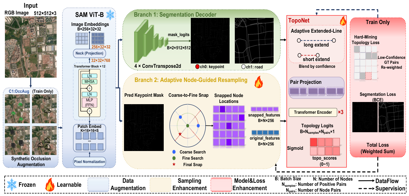
Figure 2.
Tensor flow and feature transformation from satellite image input to topology prediction.
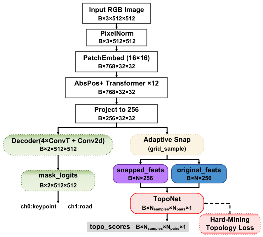
Figure 3.
Illustration of the occlusion-adaptive extended-line strategy and hard-mining topology loss.
Figure 3.
Illustration of the occlusion-adaptive extended-line strategy and hard-mining topology loss.
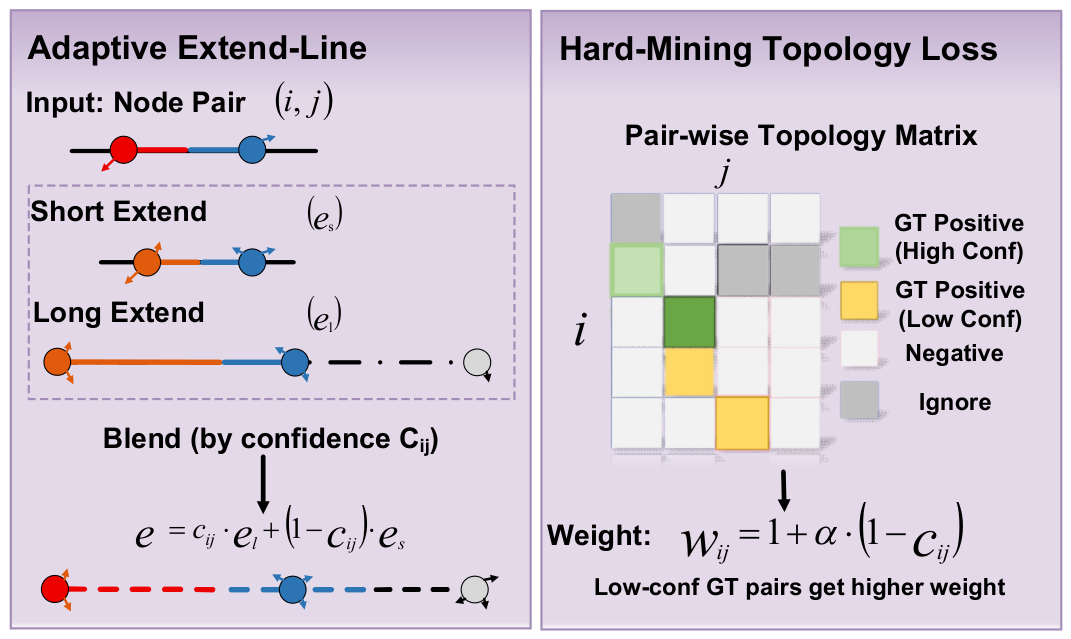
Figure 4.
Coarse-to-fine node-guided resampling under occlusion.
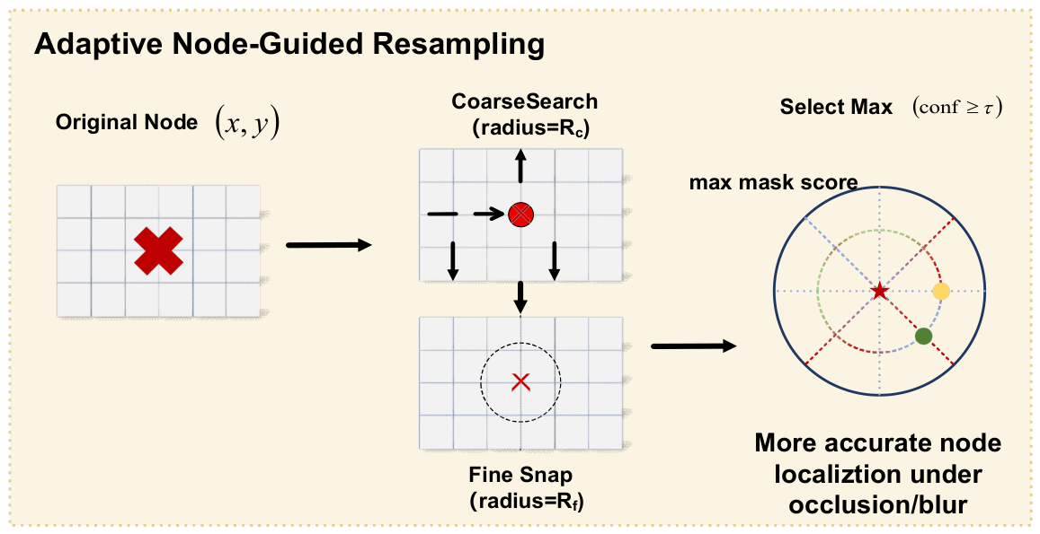
Figure 5.
Qualitative comparison of predicted road graphs on representative out-of-domain tiles.
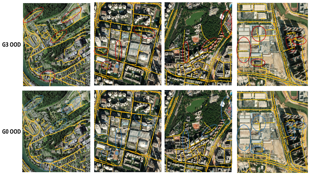
Figure 6.
Qualitative comparison of predicted road graphs under default ID-tuned thresholds and OOD-recalibrated thresholds on the same out-of-domain tiles.
Figure 6.
Qualitative comparison of predicted road graphs under default ID-tuned thresholds and OOD-recalibrated thresholds on the same out-of-domain tiles.
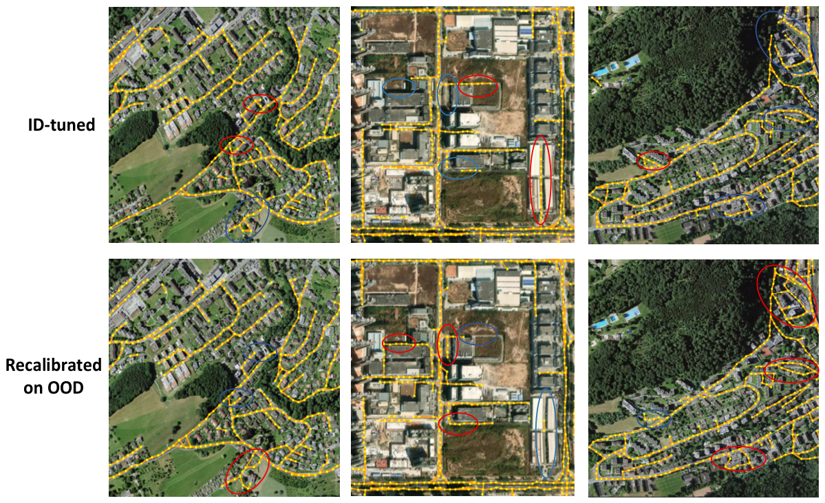

Table 1.
Tensor flow of the proposed road graph extraction framework.
| Stage | Tensor Representation | Shape |
|---|---|---|
| Input | RGB satellite image | B×3×512×512 |
| SAM encoder | Image embedding | B×256×32×32 |
| Mask decoder | Keypoint and road logits | B×2×512×512 |
| Probability maps | Keypoint and road maps | B×2×512×512 |
| Node sampling | Node feature representation | B×N×256 |
| Line sampling | Extended-line features | B×Npair×150 |
| Pair construction | Topology feature | B×Npair×408 |
| Transformer Encoder Output | Transformer | B×Nsamples ×Npairs×256 |
| TopoNet output | Edge probability | B×Nsamples ×Npairs×1 |
Table 2.
Global-Scale experiment configurations.
| Run | C1 | C2 | C3 | Dataset | Purpose |
|---|---|---|---|---|---|
| G0 | - | - | - | Global-Scale ID | Baseline for comparison and ablation |
| G1 | √ | - | - | Global-Scale ID | Adds Synthetic Occlusion Augmentation |
| G2 | √ | √ | - | Global-Scale ID | Adds adaptive extended-line learning |
| G3 | √ | √ | √ | Global-Scale ID | Full model |
Table 3.
Comparison with state-of-the-art methods on Global-Scale.
| Method | Type | F1 (ID) | F1 (OOD) | APLS (ID) | APLS (OOD) |
|---|---|---|---|---|---|
| SegFormer [9] ICCV’2021 | Pixel-wise | 42.49 | 37.27 | 24.65 | 21.36 |
| Sat2Graph [13] ECCV’2020 | Graph | 35.53 | 30.64 | 26.77 | 22.49 |
| RNGDet [11] TGRS’2022 | Iterative graph | 52.59 | 42.62 | 49.43 | 36.33 |
| RNGDet++ [12] RA-L’2023 | Iterative graph | 55.04 | 47.34 | 52.72 | 38.08 |
| SAM-Road [14] CVPRW’2024 | One-shot graph | 59.80 | 46.64 | 59.08 | 40.51 |
| SAM-Road++ [15] CVPR’2025 (original reported) |
One-shot graph | 62.33 | 48.34 | 62.19 | 43.17 |
| SAM-Road++ (reproduced, G0) |
One-shot graph | 61.81 | 46.93 | 61.74 | 41.51 |
| Ours (G3) | One-shot graph | 62.56 | 51.51 | 62.36 | 45.23 |
Table 4.
Incremental ablation study on Global-Scale with ID-OOD gap analysis. All OOD columns use the ID-tuned thresholds of each respective run (no per-run OOD recalibration). The Gap columns (ID − OOD) directly quantify how much performance is lost under distribution shift.
Table 4.
Incremental ablation study on Global-Scale with ID-OOD gap analysis. All OOD columns use the ID-tuned thresholds of each respective run (no per-run OOD recalibration). The Gap columns (ID − OOD) directly quantify how much performance is lost under distribution shift.
| Run | C1 | C2 | C3 | TOPO F1 (ID) | TOPO F1 (OOD) | Gap↓ (ID−OOD) | APLS (ID) | APLS (OOD) | Gap↓ (ID−OOD) |
|---|---|---|---|---|---|---|---|---|---|
| G0 | × | × | × | 61.81 | 46.93 | 14.88 | 61.74 | 41.51 | 20.33 |
| G1 | √ | × | × | 61.42 | 48.7 | 12.72 | 61.11 | 42.02 | 19.09 |
| G2 | √ | √ | × | 61.85 | 50.27 | 11.58 | 61.73 | 43.46 | 18.27 |
| G3 | √ | √ | √ | 62.56 | 51.51 | 11.05 | 62.36 | 45.23 | 17.13 |
Table 5.
OOD threshold recalibration on the 130 out-of-domain tiles (using the G3 checkpoint).
| Setting | TOPO F1 (OOD) | APLS (OOD) |
|---|---|---|
| Default(ID-tuned) | 51.51 | 45.23 |
| Recalibrated on OOD | 52.03 | 45.75 |
Disclaimer/Publisher’s Note: The statements, opinions and data contained in all publications are solely those of the individual author(s) and contributor(s) and not of MDPI and/or the editor(s). MDPI and/or the editor(s) disclaim responsibility for any injury to people or property resulting from any ideas, methods, instructions or products referred to in the content. |
© 2026 by the authors. Licensee MDPI, Basel, Switzerland. This article is an open access article distributed under the terms and conditions of the Creative Commons Attribution (CC BY) license (http://creativecommons.org/licenses/by/4.0/).
Copyright: This open access article is published under a Creative Commons CC BY 4.0 license, which permit the free download, distribution, and reuse, provided that the author and preprint are cited in any reuse.