

Submitted:
10 August 2026
Posted:
11 August 2026
You are already at the latest version
Abstract
The Upper Cretaceous and Jurassic karst aquifers of Sierra de Segura (southern Spain) constitute a major groundwater resource within the “Sierras de Cazorla, Segura y Las Villas,” the largest Natural Park of Spain and the second largest in Europe. Both car-bonate aquifer systems are separated by the low-permeability Utrillas Formation (UT), composed mainly of sands, sandstones, and clay-rich sediments, and its hydrogeologi-cal role remains poorly understood. To investigate the hydraulic relationship between the aquifers and assess the existence of groundwater transfer through the Utrillas Formation, major ions (Na⁺, K⁺, Ca²⁺, Mg²⁺, Cl⁻, NO₃⁻, SO₄²⁻, and HCO₃⁻) and stable wa-ter isotopes (δ¹⁸O and δ²H) were analyzed in 465 groundwater samples from 20 springs between May 2020 and October 2023. Hydrochemical results revealed a progressive evolution from the Upper Cretaceous aquifers, characterized by lower electrical con-ductivity and temperature values (520 µS/cm and 12.2 °C), to the Jurassic aquifer, where these parameters increased to 611 µS/cm and 14.9 °C. Higher concentrations of Mg²⁺, Na⁺, K⁺, Cl⁻, and SO₄²⁻ in the Jurassic system indicate a greater degree of hydro-chemical evolution, consistent with enhanced water–rock interaction and more pro-longed groundwater circulation. Principal Component Analysis identified mineraliza-tion as the dominant control on groundwater variability (48.5% of the total variance) and revealed a hydrochemical gradient from relatively homogeneous Upper Creta-ceous groundwater toward more mineralized Jurassic groundwater, while several Ju-rassic springs overlapped with the Upper Cretaceous group. The convergence of hy-drochemical, isotopic, multivariate, and temporal evidence is consistent with hydrau-lic connectivity between the two aquifer systems. Collectively, these observations support the conceptual “Shower Effect” model, whereby groundwater is inferred to be transferred from the hydraulically elevated Upper Cretaceous aquifers to the under-lying Jurassic aquifer through the low-permeability Utrillas Formation.
Keywords:
aquifer
; hydrochemistry
; groundwater transfer
; karst groundwater-dependent ecosystems (KGDEs)
; climate change
1. Introduction
Karst aquifers constitute one of the planet’s most important strategic water resources, both for their contribution to the human water supply and their role in sustaining numerous groundwater-dependent ecosystems [1] (GDEs). Carbonate formations outcrop across approximately 15 per cent of the ice-free continental surface and supply water to a significant proportion of the world’s population [1,2,3] In Mediterranean regions, which are characterized by high climatic variability, aquifers act as natural reservoirs capable of sustaining springs, wetlands, and low-flow rivers that are essential for conserving biodiversity and water resource availability.
In addition to sustaining groundwater discharge, carbonate aquifers buffer seasonal and interannual hydrological variability through groundwater storage. This buffering capacity has become increasingly important under climate change, as prolonged droughts, reduced recharge, and increasing evapotranspiration threaten both groundwater resources and groundwater-dependent ecosystems [4,5].
The sustainability of these systems currently faces significant challenges owing to climate change and other related issues. Rising temperatures, declining rainfall, and an increased frequency of drought events in the Mediterranean Basin directly affect recharge processes and groundwater availability [6,7,8]. In this context, identifying hydraulic connections and groundwater transfer mechanisms between aquifers is essential for understanding the resilience of groundwater systems to declining recharge and increasing water stress due to climate change.
The management of karst aquifers is particularly complex because of the coexistence of flows through the rock matrix, fractures, and dissolution channels, which result in marked hydraulic heterogeneity and highly variable hydrological responses across space and time [9,10,11]. Various studies have shown that the integration of hydrochemical, isotopic, and hydrodynamic tools is an effective strategy for characterizing these systems and assessing their hydrogeological behaviors [12,13,14].
In Mediterranean regions, karst aquifers also play a vital role as climatic refuges for numerous species of terrestrial and aquatic biota associated with permanently wet environments. Springs or wetlands fed by groundwater constitute habitats of high ecological uniqueness that are home to vulnerable biological communities and, in many cases, to endemic or threatened species [15,16]. The survival of these ecosystems depends directly on the stability of underground flows; therefore, disturbances to the processes of recharge, storage, or transfer between aquifers can result in biodiversity loss and reduce the resilience of groundwater-dependent ecosystems to the increasing frequency of droughts associated with climate change [17,18].
The Sierras de Cazorla, Segura, and Las Villas Natural Park is home to more than 60 carbonate aquifers that feed thousands of springs and sustain numerous groundwater-dependent ecosystems in southern Spain. The conservation of wetland habitats, headwater streams, and protected species is closely linked to the availability of groundwater resources; therefore, the identification of recharge areas and hydrogeological connections is a key aspect of protected area management.
In the Sierra de Segura, recent hydrogeological and isotopic studies have suggested the possible existence of water transfers between the Upper Cretaceous and Jurassic carbonate aquifers via the Utrillas Formation, which is traditionally considered a low-permeability unit [19]. This conceptual mechanism, referred to in this paper as the ‘Shower Effect’, proposes the possibility of the continuous transfer of water from the elevated Upper Cretaceous aquifers to the underlying Jurassic system, constituting a hypothesis with significant implications for groundwater resource assessment, ecosystem conservation, and the resilience of Mediterranean karst aquifers under changing climatic conditions.
In this context, the main objective of this study is to assess the hydrogeological connectivity between the Upper Cretaceous and Jurassic carbonate aquifers in the Sierra de Segura using hydrochemical data from groundwater, with the aim to evaluate the hydrochemical evidence for groundwater transfer that govern the joint functioning of both systems.
2. Location, Geological and Hydrogeological Context
The Sierra de Segura (province of Jaén, Southern Spain) is situated in the central sector of the Baetic System and forms the headwaters of the Guadalquivir and Segura River basins, two of the most important river systems on the Iberian Peninsula (Figure 1A). The study area covers approximately 2,100 km2 and lies entirely within the Sierras de Cazorla, Segura, and Las Villas Natural Park, the largest protected natural area in Spain and the second largest in Europe. This area also benefits from various national and international protection designations, including the Biosphere Reserve, Special Protection Area for Birds (SPA), Special Area of Conservation (SAC), Site of Community Importance (SCI), and five River Nature Reserves.
The climate is a mountainous Mediterranean [21], characterized by marked interannual variability in precipitation and strong seasonality. Based on monthly records from 90 rainfall stations, the regional precipitation series was obtained for the hydrological period 1911/12–2022/23 (SM1). Wet years were defined as those with rainfall 15 percent above the regional average, dry years as those 15 percent below, and average years as those falling between these two thresholds. The time series recorded 32 wet years, 30 average years, and 48 dry years (Figure 2). Although the time series shows the high interannual variability characteristic of the Mediterranean climate, there is a greater concentration of wet years during the early decades of the 20th century and a gradual increase in the number of dry years since the late 1980s. This pattern indicates a process of progressive reduction in regional water resources, characterized not only by a decrease in average precipitation but also by a greater recurrence of dry periods and a reduction in wet episodes that can generate significant aquifer recharges.
From a geological perspective, the area belongs to the Inner Pre-Betic domain of the Outer Zone of the Baetic System [22,23,24,25]. The stratigraphic sequence consists of impermeable Triassic materials at the base, overlain by Jurassic dolomites, and subsequently by Cretaceous carbonate and detrital units. Intercalated between the Jurassic carbonate rocks and those of the Upper Cretaceous is the Utrillas Formation, which mainly comprises sand, sandstone, and clayey layers with variable hydraulic behavior.
The regional structure is dominated by large folds associated with the Alpine deformation. As a result of this tectonic configuration, areas of inverted relief have developed, where the topographic elevations coincide with intensely karstified Upper Cretaceous carbonate rocks (Figure 3), whereas Jurassic rocks outcrop at relatively lower elevations. This arrangement decisively influences both the distribution of aquifers and the location of the primary discharge.
Hydrogeologically, the Sierra de Segura consists of two large carbonate aquifer systems separated by the Utrillas Formation. The lower system corresponds to the Jurassic dolomites, which constitute a vast regional aquifer that discharges through numerous springs and is mainly in contact with impermeable Triassic materials. The upper system consists of Cretaceous limestones and dolomites, which exhibit a high degree of karstification and are organized into multiple hanging aquifers associated with synclinal structures, known locally as ‘Calares.’
The presence of Utrillas plays a fundamental role in the hydrological and ecological functioning of this region. On the one hand, it acts as a hydraulic discontinuity that favors the emergence of numerous springs at the contact between the carbonate units and detrital materials, generating an extensive network of wetland habitats with high ecological value. However, various studies suggest that their permeability is not low enough to completely prevent vertical flow, allowing water transfer between the Upper Cretaceous and Jurassic aquifers [26]. These potential connections are particularly significant from an environmental perspective, as they could help maintain discharge rates during dry periods and conserve groundwater-dependent ecosystems that characterize natural parks.
3. Materials and Methods
3.1. Climatic Dataset and Precipitation Reconstruction
Regional climate characterization was based on monthly precipitation records from 90 rainfall stations distributed across the Sierra de Segura, covering the hydrological period of 1911/12–2022/23. Several stations contained temporal gaps owing to the length of the observation period. These missing values were reconstructed using simple linear regression, selecting the neighboring station with the highest Pearson correlation coefficient during the common observation period as a reference. For each station, precipitation was estimated as follows:
where PPi is the estimated monthly precipitation at the target station, PPref is the monthly precipitation recorded at the reference station, a is the intercept of the regression equation, and b is the regression slope. The regression parameters were calculated individually for each station pair using an overlapping observation period. The reconstruction procedure was then applied iteratively to maximize data recovery, while preserving the temporal and spatial consistency of the precipitation series. The correlation coefficients were consistently high, generally exceeding 0.89 (Supplementary Material S1).
PPi= a + b * PPref
The final database comprised 9,902 potential monthly records, of which 4,231 (42.6%) corresponded to original observations and 2,251 (23.1%) were reconstructed using correlation-based estimation, increasing the usable dataset to 65.3% of the potential records. The remaining 3,420 observations (34.4%) were intentionally retained as missing because no statistically reliable reconstruction could be obtained owing to the simultaneous absence of records at neighboring stations or insufficient temporal overlap between the available series. This conservative approach prioritizes the statistical robustness of the climatic dataset over the generation of an artificially continuous record. The similarity between the mean annual precipitation calculated from the original observations (806 mm) and that obtained after reconstruction (813 mm) indicates that the gap-filling procedure introduced no appreciable bias into the long-term precipitation series (Table S1).
Finally, annual regional precipitation was calculated as the arithmetic mean of all available station records for each hydrological year, producing a representative regional precipitation series for evaluating long-term climatic variability and trends in Sierra de Segura.
3.2. Groundwater Sampling and Field Measurements
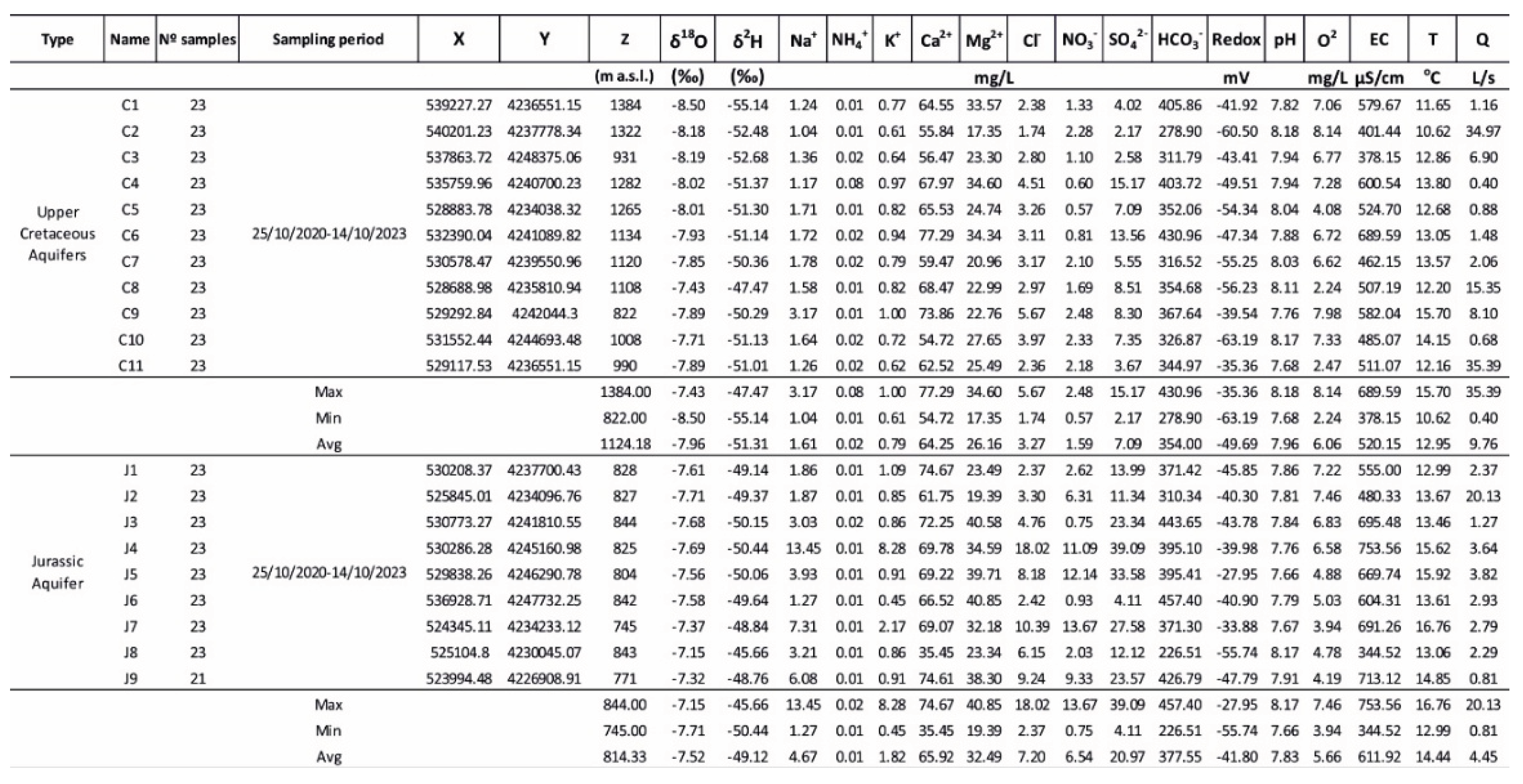
To obtain hydrochemical data, 21 sampling campaigns were conducted between May 2020 and October 2023 at 20 springs representative of the region’s main aquifer systems, of which 9 corresponded to the Jurassic aquifer and 11 to the Upper Cretaceous aquifer (Table 1).
In total, 465 water samples were collected and analyzed (Supplementary Material, SM 2). The characterization of the samples included the determination of physicochemical, hydrochemical, and isotopic parameters using ion chromatography and isotopic spectroscopy techniques. After collection, the samples were filtered in the laboratory and stored in 5 mL polypropylene vials filled to the brim to prevent the ingress of air and were kept refrigerated until analytical processing. The analytical quality of the hydrochemical data was assessed by calculating the ionic balance error, which yielded a mean ionic balance average value of 3.29.
3.3. Hydrochemical Analyses and Quality Control
During fieldwork, in situ measurements of pH, electrical conductivity (EC) and temperature (T), levels were conducted. For this purpose, a HI 9828 multiparameter analyzer (Hanna Instruments) was used to measure the pH, EC and T. The flow rate of each spring was measured at the same time intervals as the previous in situ measurements, and samples were taken for analysis in the laboratory, where analyses of the major anions and cations (Ca2+, Mg2+, Na+, K+, F-, Cl-, SO42-, NO3–; for convenience, the ionic charge of the ions will not be specified hereafter) were carried out on both groundwater and precipitation samples using the ion chromatograph at the Department of Geology, University of Jaén, a Professional IC 850 with a Metrohm 919 IC Autosampler Plus with a precision of ±0.01 mg/L.
In addition, two continuous monitoring devices were installed at spring J2: an Odyssey sensor to record the water table level and a HOBO meter to record EC and T. Furthermore, bicarbonates were determined by acid-base titration using an Aquamerck alkalinity test kit.
3.4. Stable Isotope Analyses
The stable isotope composition of precipitation (δ18O and δ2H) was determined at the Stable Isotope Laboratory of the University of Almería (Spain) using a Picarro L2140-i cavity ring-down spectroscopy (CRDS) analyzer [27] Isotopic measurements were calibrated to the Vienna Standard Mean Ocean Water (V-SMOW) reference scale through repeated analyses of laboratory standards performed before and after each analytical sequence of 12–15 samples. Three in-house reference waters, previously calibrated against the international standards V-SMOW, Standard Light Antarctic Precipitation (SLAP), and Greenland Ice Sheet Precipitation (GISP), were used to normalize the analytical results. The isotopic compositions are expressed in delta notation (‰) relative to V-SMOW. The analytical procedures are described in detail by [28]. The long-term precision (1σ) of oxygen and hydrogen isotope analyses were evaluated by measuring an internal standard for every 5–6 samples and was ± 0.1 ‰, and ± 0.6 ‰ for δ18O and δ2H, respectively.
3.5. Hydrochemical and Multivariate Statistical Analyses
Once the concentrations of the major ions were determined, Principal Component Analysis (PCA) and bivariate ionic relationships were used to investigate the main hydrochemical processes controlling groundwater composition and to evaluate hydrochemical similarities and differences between the Upper Cretaceous and Jurassic aquifers. The PCA included electrical conductivity (EC), temperature (T), pH, spring discharge (Q), the major dissolved ions Ca, Mg, Na, K, Cl, SO4, NO3, and HCO3, and the stable isotope compositions δ18O and δ2H. Because these variables were expressed in different units and exhibited different ranges of variation, the dataset was standardized prior to PCA using z-score transformation (mean = 0 and standard deviation = 1), and the analysis was performed on the correlation matrix of the standardized variables. Sample scores and variable loadings were jointly examined to characterize the multivariate organization of the groundwater system. The F1–F2 projection was used to identify the dominant hydrochemical gradient and evaluate the degree of overlap between groundwater from the two aquifer systems, whereas the F1–F3 projection was examined to identify secondary hydrochemical variability among individual springs.
In parallel, bivariate ionic relationships were evaluated using concentrations expressed in milliequivalents per liter (meq/L). The relationships HCO3–(Ca + Mg), HCO3–SO4, Ca–Mg, Na–Cl, SO4–Cl, and SO4–NO3 were examined to assess carbonate dissolution, groundwater mineralization, and hydrochemical differentiation between aquifers. The PCA and ionic relationships were interpreted jointly with the geological and hydrogeological setting, stable isotope composition, and temporal groundwater response to evaluate whether the observed hydrochemical patterns were consistent with progressive groundwater evolution and the proposed hydraulic connectivity between the Upper Cretaceous and Jurassic aquifers, while also considering the influence of lithology and local groundwater flow paths.
4. Results and Discussion
4.1. Hydrochemical Caracterization
Groundwater from both the Upper Cretaceous and Jurassic aquifers is characterized by a Ca–Mg–HCO3 hydrochemical facies, reflecting the predominance of carbonate lithologies throughout the study area (Figure 4A). The Piper diagram shows that all groundwater samples plot within the bicarbonate facies, although the spatial distribution of the samples differed between aquifers. Groundwater from the Upper Cretaceous aquifer forms a compact cluster close to the bicarbonate apex, whereas Jurassic groundwater exhibits a broader distribution extending towards higher proportions of Na, Cl and SO4. Springs J4 and J7 occupy the most evolved positions within the Jurassic group, while springs J1, J2, J3 and J6 plot close to the Upper Cretaceous cluster. Spring J8 is an exception, displaying a hydrochemical composition similar to that of the Upper Cretaceous despite discharging from Jurassic carbonate formations.
The Schoeller–Berkaloff diagram (Figure 4B) showed similar overall ionic patterns in groundwater from both aquifers, with HCO3 as the dominant anion and Ca and Mg as the dominant cations. Upper Cretaceous groundwater exhibited relatively homogeneous ionic compositions, whereas Jurassic groundwater showed greater variability, particularly in Mg, Cl, and SO4 concentrations.
Calcium was the dominant cation in both aquifers, with similar mean concentrations in the Upper Cretaceous (64.3 mg/ l) and Jurassic groundwater (65.9 mg/L) (Table 1). In contrast, Mg showed a clearer difference between the two systems. Concentrations ranged from 17.4 to 34.3 mg/ l (mean 26.1 mg/ l) in the Upper Cretaceous aquifer and from 19.3 to 40.8 mg/L (mean 32.4 mg/ l) in the Jurassic aquifer. The highest Mg concentrations were recorded at springs J4, J5, J7, and J9, whereas J8 showed values comparable to those observed in the Upper Cretaceous groundwater.
Sodium concentrations remained low in most groundwater samples but exhibited a wider range in the Jurassic aquifer (1.2–13.4 mg/L; mean 4.6 mg/L) than in the Upper Cretaceous aquifer (1.04–3.17 mg/L; mean 1.61 mg/L). Potassium concentrations were also low, averaging 0.79 mg/L in the Upper Cretaceous aquifer and 1.82 mg/L in the Jurassic aquifer.
Bicarbonate was the dominant anion in both aquifers, with mean concentrations of 354 mg/L in the Upper Cretaceous groundwater and 377 mg/L in the Jurassic groundwater. More pronounced differences were observed for Cl and SO4. Mean Cl concentrations increased from 3.27 mg/L in the Upper Cretaceous aquifer to 7.20 mg/L in the Jurassic aquifer, whereas mean SO4 concentrations increased from 7.09 to 20.9 mg/L. The highest SO4 concentrations were consistently recorded at springs J4, J5, J7, and J9.
The general hydrochemical relationships shown in Figure 5 reveal systematic differences between groundwater from the Upper Cretaceous and Jurassic aquifers.
The electrical conductivity ranges between 378 and 689 μS/cm in the Upper Cretaceous aquifer, with an average value of 520 μS/cm, whereas Jurassic groundwater ranges from 344 to 753 μS/cm and exhibits a higher average conductivity of 611 μS/cm (Figure 5A, Table 1). The highest electrical conductivity values corresponded to springs J4 and J9, whereas spring J8 recorded the lowest conductivity within the Jurassic aquifer.
The relationship between bicarbonate concentration and pH (Figure 5B) shows that Jurassic groundwater generally has higher bicarbonate concentrations than groundwater from the Upper Cretaceous aquifer. Upper Cretaceous springs form a relatively compact group, characterized by lower HCO3 concentrations.
Groundwater temperature ranged from 10.6 to 15.7 °C in the Upper Cretaceous aquifer and from 12.9 to 16.7 °C in the Jurassic aquifer (Figure 5C). Jurassic groundwater therefore showed generally higher temperatures and a narrower range of variation than Upper Cretaceous groundwater.
The relationship between groundwater temperature and magnesium concentration (Figure 5D) indicates that the highest Mg concentrations are associated with the warmest groundwater samples, which are predominantly located in the Jurassic aquifer. In contrast, most Upper Cretaceous springs display lower temperatures and magnesium concentrations.
The ionic relationships shown in Figure 6 further characterize the distribution of the major dissolved ions in groundwater from the Upper Cretaceous and Jurassic aquifers in the study area. The HCO3–(Ca + Mg) relationship (Figure 6A) showed a strong positive association, with most samples distributed close to the carbonate dissolution trend. Upper Cretaceous groundwater formed a relatively compact cluster, whereas Jurassic samples covered a broader range toward higher HCO3 and alkaline-earth cation concentrations. The HCO3–SO4 relationship (Figure 6B) similarly showed a compact distribution for most Upper Cretaceous samples, while springs J4, J5, J7, and J9 were characterized by higher SO4 concentrations.
The Ca–Mg relationship (Figure 6C) showed substantial overlap between the two aquifers for Ca, whereas the highest Mg concentrations occurred exclusively in Jurassic groundwater. The Na–Cl relationship (Figure 6D) showed low and relatively homogeneous concentrations in the Upper Cretaceous groundwater, while Jurassic samples displayed greater dispersion and included several samples with comparatively higher Na concentrations. Similar differentiation was observed in the SO4–Cl and SO4–NO3 relationships (Figure 6E,F), where springs J4, J5, J7, and J9 consistently occupied the higher-concentration range of the Jurassic dataset.
4.2. Principal Component Analysis
Principal component analysis (PCA) reduced the hydrochemical and isotopic datasets to three principal components, which together explained 77.6% of the total variance (Figure 7).
Factor 1 (F1) accounts for 48.5% of the total variance and is characterized by positive loadings of temperature, electrical conductivity, Na, Cl, SO4, HCO3, Ca and Mg, together with negative loadings of discharge and pH. Factor 2 (F2) explained 19.7% of the variance and was mainly associated with δ18O, δ2H, pH, and alkalinity. Factor 3 (F3), representing 10.1% of the variance, was dominated by positive loadings of K, Na, Cl, and NO3, whereas Ca, Mg, HCO3, electrical conductivity, temperature, and the isotopic variables exhibited negative loadings.
The score plot in the F1–F2 plane (Figure 7A) reveals two principal groundwater groups. Samples from the Upper Cretaceous aquifer occupied the negative side of F1 and formed a relatively compact cluster. Jurassic groundwater displayed a broader distribution along the positive direction of F1, although several springs (J1, J2, J3, J6, and J8) overlapped with the Upper Cretaceous group. Springs J4, J5, J7 and J9 are located at the positive extreme of the first principal component.
The loading plot (Figure 7B) shows that the hydrochemical variables associated with groundwater mineralization are mainly grouped along the first principal component, whereas the stable isotopes (δ18O and δ2H) are primarily associated with the second component.
The F1–F3 projections (Figure 7C) provides additional separation among the Jurassic groundwater samples, particularly those displaying contrasting Na, K, Cl, and NO3 contents.
4.3. Temporal Hydrochemical and Isotopic Evolution
Temporal variations in the principal hydrochemical and isotopic parameters were analyzed using two representative springs: C2, representative of the Upper Cretaceous aquifer, and J2, representative of the Jurassic aquifer (Figure 8).
Spring C2 exhibited pronounced temporal variability in most monitored parameters. Variations in δ18O, electrical conductivity, groundwater temperature, and discharge occurred shortly after the main precipitation events. Bicarbonate, calcium, and magnesium concentrations also fluctuated throughout the monitoring period, with higher variability than that observed in the Jurassic spring.
In contrast, spring J2 displayed smaller temporal fluctuations. Variations in δ18O were attenuated throughout the study period, whereas electrical conductivity, groundwater temperature, and the major dissolved ions remained comparatively stable. Groundwater discharge also exhibited a smoother temporal evolution than that observed in spring C2.
Overall, the monitored variables indicated higher temporal variability in the Upper Cretaceous spring than in the Jurassic spring throughout the monitoring period.
5. Disscusion
5.1. Hydrochemical Evolution of the Carbonate Aquifer System
The hydrochemical results suggest that both the Upper Cretaceous and Jurassic aquifers belong to the Ca–Mg–HCO3 facies, indicating that carbonate dissolution is the dominant geochemical process controlling groundwater composition throughout the study area. This hydrochemical facies is characteristic of carbonate aquifers worldwide and has been widely reported in Mediterranean karst systems developed within the Betic Cordillera [29,30], the Swiss Jura [31], and the Alps [32]
Despite this common hydrochemical facies, the two aquifers exhibited markedly different degrees of chemical evolution. The Upper Cretaceous springs show a remarkably homogeneous composition characterized by relatively low electrical conductivity and limited variability in the major dissolved ions, whereas Jurassic groundwater displays significantly greater chemical dispersion together with systematic enrichment in Mg, Na, Cl, and SO4. Similar hydrochemical patterns have been interpreted in other regional carbonate aquifers, reflecting differences in groundwater circulation, residence time, and the progressive integration of recharge waters during subsurface flow [33,34].
The increase in groundwater mineralization observed within the Jurassic aquifer was accompanied by higher bicarbonate and magnesium concentrations. Calcite dissolution rapidly controls groundwater chemistry after recharge, whereas dolomite dissolution proceeds more slowly and becomes progressively more important during prolonged groundwater circulation. Consequently, Mg has frequently been identified as one of the most reliable hydrochemical indicators of groundwater residence time in carbonate aquifers [30,35]. The present results are consistent with these observations, as the highest Mg concentrations consistently occurred in the most mineralized Jurassic springs.
Overall, the hydrochemical dataset therefore reveals a continuum rather than two completely independent groundwater populations. Upper Cretaceous groundwater defines a relatively homogeneous and less mineralized end member, whereas Jurassic groundwater spans a wider hydrochemical range, from compositions closely resembling those of the Upper Cretaceous aquifer to substantially more mineralized groundwater. This internal heterogeneity within the Jurassic aquifer provides the basis for evaluating the coexistence of local and regional flow components and their potential relationship with inter-aquifer groundwater transfer.
5.2. Groundwater Circulation and Inter-Aquifer Hydraulic Connectivity
The combined interpretation of hydrochemical, isotopic, multivariate, and temporal datasets revealed the coexistence of different groundwater flow systems within the Sierra de Segura aquifer system. While the Upper Cretaceous springs display a relatively homogeneous chemical composition and rapid temporal response to recharge, the Jurassic aquifer exhibits wider hydrochemical variability and attenuated temporal fluctuations, indicating greater groundwater storage and more complex circulation pathways.
The PCA supports this interpretation by separating the hydrochemical variables associated with groundwater mineralization from the stable isotopes, which mainly preserve the recharge signature of the water. Similar results have been reported in the carbonate aquifers of the Kras Region of Slovenia [36], southern China [37], and other Mediterranean karst systems [38,39], where hydrochemistry reflects groundwater evolution during subsurface flow, whereas stable isotopes primarily record recharge conditions. This decoupling suggests that groundwater mineralization in the Sierra de Segura is controlled more by groundwater circulation than by recharge altitude.
The hydrochemical behavior of springs J1, J2, J3, J6, and particularly J8, further supports the existence of local flow systems within the Jurassic aquifer. Their low mineralization contrasts with that of springs J4, J5, J7, and J9, which represent the most evolved groundwater. Similar hydrochemical heterogeneity has been interpreted as evidence of the coexistence of local and regional groundwater circulation in other carbonate aquifers [34,40]. Together with the temporal analysis, these results indicate that the Jurassic aquifer integrates groundwater with contrasting residence times and flow paths.
This progressive groundwater integration also increases the hydrological buffering capacity of aquifers. The coexistence of local and regional flow systems allows the recharge received during wet periods to be progressively redistributed through deeper groundwater circulation, thereby reducing seasonal variability in spring discharge. Similar behavior has been documented in high-mountain karst aquifers, where groundwater storage exerts primary control on discharge persistence during dry periods [41].
5.3. Conceptual Model of the Aquifer Systems and “Shower Effect”
This interpretation is consistent with the geological configuration of the study area. The Upper Cretaceous carbonate aquifers occupy the highest elevations of the massif and are separated from the Jurassic aquifer by the Utrillas Formation, which acts as a regional aquitard. Rather than behaving as a completely impermeable layer, its heterogeneous lithological composition permits slow diffuse leakage and localized preferential flow, allowing recharge stored in the Upper Cretaceous aquifers to progressively reach the deeper Jurassic groundwater system. Similar hydraulic transfer processes have been described in multilayer carbonate aquifers, where low-permeability formations reduce, but do not completely prevent, groundwater exchange between adjacent aquifers [10,42].
The coexistence of Jurassic springs with markedly different degrees of hydrochemical evolution further supports this conceptual model. Springs J4, J5, J7 and J9 represent groundwater that has undergone prolonged circulation and extensive water–rock interaction, whereas springs J1, J2, J3, J6 and particularly J8 preserve hydrochemical and isotopic characteristics similar to those of the Upper Cretaceous aquifer. This variability is consistent with the coexistence of local and regional groundwater flow systems, where groundwater transferred from the Upper Cretaceous aquifer follows different circulation pathways and residence times before being discharged through the Jurassic aquifer.
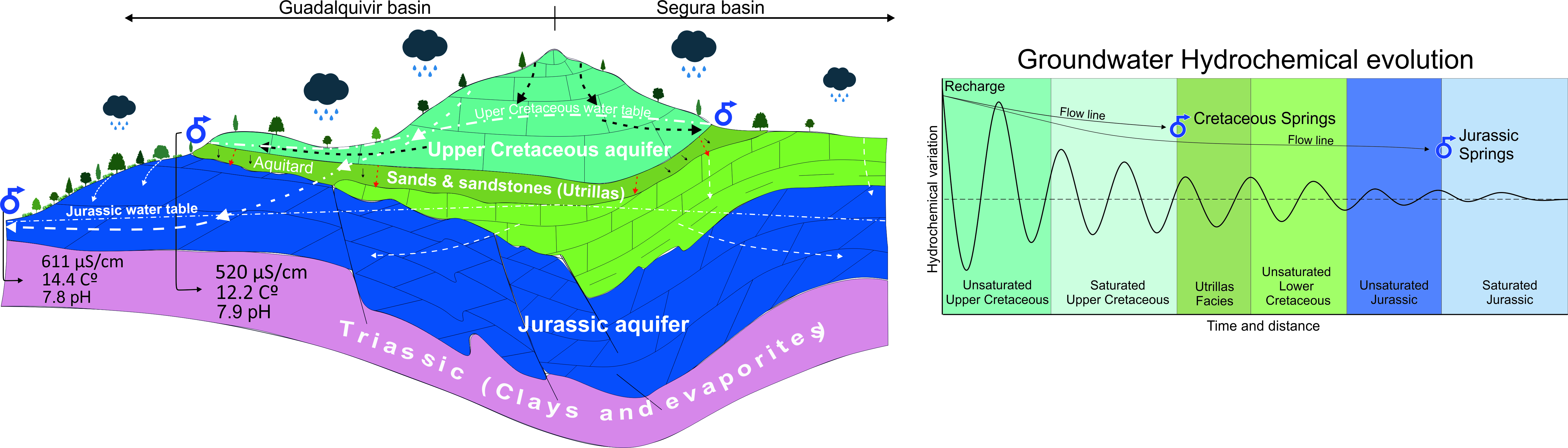
Based on these multiple lines of evidence, a conceptual model referred to as the “Shower Effect” is proposed (Figure 9). In this model, the Upper Cretaceous aquifers behave as hydraulically elevated recharge reservoirs that progressively redistribute part of the infiltrated groundwater towards the underlying Jurassic aquifer through the semi-permeable Utrillas Formation. This process increases the effective groundwater storage of the regional system, prolongs groundwater residence times, and contributes to maintaining spring discharge during periods of reduced recharge. Rather than representing a simple vertical leakage process, the proposed model highlights the role of hydraulic connectivity in regulating groundwater storage and discharge within multilayered carbonate aquifer systems.
From a broader hydrogeological perspective, the proposed “Shower Effect” represents a hydrological buffering mechanism. Rather than simply transferring groundwater between aquifers, hydraulic connectivity increases the effective storage capacity of the regional system and delays groundwater release after recharging events. This behavior enhances the resilience of groundwater resources under progressively drier climatic conditions.
5.4. Implications for Groundwater Resources Under Climate Change
The hydrogeological model proposed in this study has implications beyond the Sierra de Segura Aquifer System. Mediterranean mountain regions are experiencing progressively lower recharge due to declining precipitation and increasing evapotranspiration [6,8]. Under these conditions, groundwater systems capable of storing and progressively redistributing recharge have become increasingly important for sustaining spring discharge during prolonged dry periods. Recent studies in Mediterranean and mountain karst systems have shown that groundwater storage is the principal mechanism controlling the persistence of spring discharge under declining recharge conditions [5]. The hydrochemical evidence presented here indicates that hydraulic transfer between the Upper Cretaceous and Jurassic aquifers contributes to this buffering behavior by increasing groundwater storage and attenuating seasonal hydrological variability.
The results suggest that hydraulic transfer from the Upper Cretaceous to the Jurassic aquifer increases the effective storage capacity of the regional groundwater system. By progressively releasing recharge through the deeper aquifer, this mechanism attenuates seasonal hydrological variability and contributes to maintaining groundwater resources during drought conditions. Similar buffering effects have been recognized in regional carbonate aquifers [34,42], although they have rarely been interpreted within the context of climate change resilience. Consequently, the hydrogeological significance of hydraulic connectivity extends beyond groundwater resource assessments. By sustaining spring discharge during prolonged droughts, interconnected carbonate aquifers contribute to maintaining groundwater-dependent ecosystems and increasing the resilience of protected mountain landscapes under future climate-change scenarios.
These findings have practical implications for groundwater management. The Upper Cretaceous and Jurassic aquifers should be considered components of a single hydraulically connected system rather than independent groundwater bodies. Consequently, changes affecting recharge areas in Upper Cretaceous outcrops may influence groundwater storage and spring discharge within the Jurassic aquifer.
Finally, the conceptual “Shower Effect” proposed here provides a framework for understanding groundwater redistribution in multi-layer carbonate aquifer systems. Although its quantitative contribution should be assessed using complementary approaches such as environmental tracers or numerical modelling, the agreement between the geological, hydrochemical, isotopic and temporal evidence suggests that similar recharge-transfer mechanisms may operate in other Mediterranean carbonate aquifers.
Hydrochemical and isotopic data alone cannot provide direct proof of groundwater transfer. However, when interpreted together with the geological framework, the temporal groundwater response, and the multivariate analyses, they provide a coherent and internally consistent body of evidence supporting the proposed conceptual model. Alternative explanations based solely on lithological differences or local groundwater evolution do not satisfactorily explain the combined spatial, temporal, and hydrochemical patterns observed across the study area.
6. Conclusions
The integrated hydrochemical, physicochemical, isotopic, and multivariate characterization of the Sierra de Segura carbonate aquifer system reveals two hydrochemically differentiated but hydraulically connected carbonate aquifer systems. Although groundwater from both the Upper Cretaceous and Jurassic aquifers is dominated by a Ca–Mg–HCO3 facies, the Jurassic aquifer exhibits greater hydrochemical variability and a higher degree of mineralization, consistent with more extensive water–rock interaction and more complex groundwater circulation than the overlying Upper Cretaceous aquifers.
The combined interpretation of hydrochemical composition, ionic relationships, stable isotopes, principal component analysis, and temporal groundwater variability provides convergent evidence supporting hydraulic connectivity between the Upper Cretaceous and Jurassic aquifers. The hydrochemical continuum identified by the PCA, together with the transitional characteristics observed in several Jurassic springs, is consistent with groundwater transfer through the low-permeability Utrillas Formation rather than with two completely independent groundwater systems.
Based on these multiple lines of evidence, the conceptual mechanism referred to as the “Shower Effect” is proposed to explain groundwater redistribution within this multilayer carbonate aquifer system. In this model, the hydraulically elevated Upper Cretaceous aquifers function as recharge reservoirs from which part of the infiltrated groundwater is progressively transferred toward the underlying Jurassic aquifer through the Utrillas Formation. Rather than acting as an impermeable barrier, the Utrillas Formation behaves as an aquitard that restricts vertical flow while allowing hydraulic exchange between both carbonate aquifers, thereby increasing the effective storage and temporal integration of recharge within the regional groundwater system.
Although hydrochemical and isotopic datasets cannot directly demonstrate groundwater transfer, the convergence of independent hydrochemical, isotopic, temporal, geological, and multivariate evidence provides strong support for the proposed conceptual model of hydraulic connectivity. These findings highlight the importance of considering hydraulically connected carbonate aquifers as components of an integrated regional groundwater system, particularly in Mediterranean mountain regions where groundwater buffering plays a key role in sustaining water resources and groundwater-dependent ecosystems under increasing climatic stress. Future studies integrating environmental and artificial tracers, groundwater dating, hydraulic monitoring, and numerical groundwater-flow modelling will be required to quantify inter-aquifer fluxes and evaluate the hydrological significance of the proposed conceptual model.
Supplementary Materials
The following supporting information can be downloaded at: Preprints.org, Suplementary material 1. Suplementary material 2.
Author Contributions
Conceptualization, A.L.M.G., A.G.-R., and J.J.; Methodology, A.L.M.-G., A.G.-R., and J.J.; Software A.L.M.G.; Validation, J.J., R.J.E. F.G.S, and F.M.M.; formal analysis, J.J.; Investigation, A.L.M.G. and A.G.R.; Resources, A.L.M.G. and F.G.; Data curation, A.L.M.G. and J.J.; Writing—Original draft preparation, A.L.M.-G., J.J. and A.G.-R.; Writing—Review and editing, A.L.M.G. and J.J.; visualization, A.L.M.G..; Supervision, R.J.E., F.M.M., F.G., J.J., and A.G.-R.; project administration, A.L.M.-G.; funding acquisition, R.J.-E. All authors have read and agreed to the published version of the manuscript.
Funding
This research received the economic contribution of the research group RNM-325 of the University of Jaén, the Geological and Mining Institute of Spain (IGME-CSIC), and the research group RNM-189 of the Department of Biology and Geology of the University of Almería. F.G acknowledges the Ramón y Cajal fellowship, RYC2020-029811-I of the Agencia Estatal de Investigación of the Ministerio de Ciencia e Innovación of Spain and the grant PPIT-UAL, Junta de Andalucía-FEDER 2022-2026 (RyC-PPI2021-01).
Data Availability Statement
Dataset available on request from the authors.
Acknowledgments
The authors thank the University of Jaén, University of Almería, and Geological Service of Spain (IGME-CSIC) for their institutional support. The authors also acknowledge the scientific collaboration of the research project PID2024-158529NB-I00.
Conflicts of Interest
The authors declare no conflicts of interest. The funders had no role in the design of the study; in the collection, analyses, or interpretation of data; in the writing of the manuscript; or in the decision to publish the resultss.
References
- Stevanović, Z. Karst Waters in Potable Water Supply: A Global Scale Overview. Environ. Earth Sci. 2019, 78. [Google Scholar] [CrossRef]
- Ford, D.; Williams, P.W. (Paul W. Karst Hydrogeology and Geomorphology; John Wiley & Sons: Hoboken, NJ, USA, 2007; ISBN 9780470849965.; John Wiley & Sons, 2007; ISBN 9780470849965. [Google Scholar]
- Goeppert, N.; Goldscheider, N.; Berkowitz, B. Experimental and Modeling Evidence of Kilometer-Scale Anomalous Tracer Transport in an Alpine Karst Aquifer. Water Res. 2020, 178. [Google Scholar] [CrossRef] [PubMed]
- Hartmann, A.; Jasechko, S.; Gleeson, T.; Wada, Y.; Andreo, B.; Barbera, J.A.; Brielmann, H.; Bouchaou, L.; Charlier, J.B.; Darling, W.G.; et al. Risk of Groundwater Contamination Widely Underestimated Because of Fast Flow into Aquifers. Proc. Natl. Acad. Sci. U. S. A. 2021, 118. [Google Scholar] [CrossRef] [PubMed]
- Jódar, J.; González-Ramón, A.; Martos-Rosillo, S.; Heredia, J.; Herrera, C.; Urrutia, J.; Caballero, Y.; Zabaleta, A.; Antigüedad, I.; Custodio, E.; et al. Snowmelt as a Determinant Factor in the Hydrogeological Behaviour of High Mountain Karst Aquifers: The Garcés Karst System, Central Pyrenees (Spain). Sci. Total Environ. 2020, 748. [Google Scholar] [CrossRef] [PubMed]
- García-Ruiz, J.M.; Lana-Renault, N. Hydrological and Erosive Consequences of Farmland Abandonment in Europe, with Special Reference to the Mediterranean Region—A Review. Agric. Ecosyst. Environ. 2011, 140, 317–338. [Google Scholar] [CrossRef]
- Vicente-Serrano, S.M.; Lopez-Moreno, J.I.; Beguería, S.; Lorenzo-Lacruz, J.; Sanchez-Lorenzo, A.; García-Ruiz, J.M.; Azorin-Molina, C.; Morán-Tejeda, E.; Revuelto, J.; Trigo, R.; et al. Evidence of Increasing Drought Severity Caused by Temperature Rise in Southern Europe. Environ. Res. Lett. 2014, 9. [Google Scholar] [CrossRef]
- IPCC. Climate Change 2023: Synthesis Report. 2023. [Google Scholar] [CrossRef]
- Bakalowicz, M. Karst Groundwater: A Challenge for New Resources. Hydrogeol. J. 2005, 13, 148–160. [Google Scholar] [CrossRef]
- Worthington, S.R.H. Diagnostic Hydrogeologic Characteristics of a Karst Aquifer (Kentucky, USA). Hydrogeol. J. 2009, 17, 1665–1678. [Google Scholar] [CrossRef]
- White, W.B. Karst Hydrology: Recent Developments and Open Questions. Eng. Geol. 2002, 65, 85–105. [Google Scholar] [CrossRef]
- Fernández-Ortega, J.; Barberá, J.A.; Andreo, B. Real-Time Karst Groundwater Monitoring and Bacterial Analysis as Early Warning Strategies for Drinking Water Supply Contamination. Sci. Total Environ. 2024, 912, 169539. [Google Scholar] [CrossRef] [PubMed]
- Mudarra, M.; Andreo, B. Relative Importance of the Saturated and the Unsaturated Zones in the Hydrogeological Functioning of Karst Aquifers: The Case of Alta Cadena (Southern Spain). J. Hydrol. (Amst) . 2011, 397, 263–280. [Google Scholar] [CrossRef]
- Barberá, J.A.; Mudarra, M.; Andreo, B.; De la Torre, B. Regional-Scale Analysis of Karst Underground Flow Deduced from Tracing Experiments: Examples from Carbonate Aquifers in Malaga Province, Southern Spain. Hydrogeol. J. 2018, 26, 23–40. [Google Scholar] [CrossRef]
- Bertrand, G.; Goldscheider, N.; Gobat, J.-M.; Hunkeler, D. Review: From Multi-Scale Conceptualization to a Classification System for Inland Groundwater-Dependent Ecosystems. Hydrogeol. J. 2012, 20, 5–25. [Google Scholar] [CrossRef]
- Kløve, B.; Ala-Aho, P.; Bertrand, G.; Gurdak, J.J.; Kupfersberger, H.; Kværner, J.; Muotka, T.; Mykrä, H.; Preda, E.; Rossi, P.; et al. Climate Change Impacts on Groundwater and Dependent Ecosystems. J. Hydrol. (Amst) . 2014, 518, 250–266. [Google Scholar] [CrossRef]
- Eamus, D.; Fu, B.; Springer, A.E.; Stevens, L.E. Groundwater Dependent Ecosystems: Classification, Identification Techniques and Threats. In Integrated Groundwater Management; Springer International Publishing: Cham, 2016; pp. 313–346. [Google Scholar]
- Siegel, L.; Goldscheider, N.; Petitta, M.; Xanke, J.; Andreo, B.; Bakalowicz, M.; Barberá, J.A.; Bouhlila, R.; Burg, A.; Doummar, J.; et al. Distribution, Threats and Protection of Selected Karst Groundwater-Dependent Ecosystems in the Mediterranean Region. Hydrogeol. J. 2023, 31, 2231–2249. [Google Scholar] [CrossRef]
- Morales-González, A.L.; Jódar, J.; Jiménez-Espinosa, R.; González-Ramón, A.; Morales-González, A.L.; Jódar, J.; Jiménez-Espinosa, R.; González-Ramón, A. Comparison between Two Methodologies for the Determination of the Recharge Heights in Springs of the Sierra de Segura (Jaén) Based on Environmental Isotopes. In Proceedings of the 76th Scientific Session (Segura de La Sierra), 2024; Spanish Geological Society. [Google Scholar]
- Juan Antonio Vera Vera, J.A. (Ed.) Geología de España; Sociedad Geológica de España–Instituto Geológico y Minero de España (SGE–IGME): Madrid, 2004; ISBN 84-7840-546-1 (978-84-7840-546-6). [Google Scholar]
- Chazarra Bernabé, A.; Flórez García, E.; Peraza Sánchez, B.; Tohá Rebull, T.; Lorenzo Mariño, B.; Criado Pinto, E.; Moreno García, J.V.; Romero Fresneda, R.; Botey Fullat, R. Mapas Climáticos de España (1981–2010) y ETo (1996–2016); Agencia Estatal de Meteorología: Madrid, Spain, 2018; Agencia Estatal de Meteorología, 2018. [Google Scholar]
- Foucault, A. Étude Géologique Des Environs Des Sources Du Guadalquivir (Provinces de Jaén et de Grenade, Espagne Méridionale); 1971. [Google Scholar]
- Dabrio, C.J. Geología Del Sector Del Alto Segura (Zona Prebética). Tesis Doctoral, Universidad de Granada, 1973. [Google Scholar]
- García-Hernández, M. El Jurásico Terminal y El Cretácico Inferior En Las Sierras de Cazorla y Del Segura (Zona Prébetica). Doctoral Dissertation, Universidad de Granada, 1978. [Google Scholar]
- Moral, F. Contribución al Conocimiento de Los Acuíferos Carbonáticos de La Sierra de Segura (Alto Guadalquivir y Alto Segura). Doctoral Dissertation, Universidad Pablo de Olavide, 2005. [Google Scholar]
- Morales González, A.L.; Jódar Bermúdez, J.; Moral Martos, F.; Jiménez Espinosa, R.; Gázquez Sánchez, F.; González Ramón, A. Modelo Conceptual Hidrogeológico de Los Acuíferos Jurásicos y Cretácico La Sierra de Segura (SE de España); Barcelona, June 2026. [Google Scholar]
- Steig, E.J.; Gkinis, V.; Schauer, A.J.; Schoenemann, S.W.; Samek, K.; Hoffnagle, J.; Dennis, K.J.; Tan, S.M. Calibrated High-Precision 17O-Excess Measurements Using Cavity Ring-down Spectroscopy with Laser-Current-Tuned Cavity Resonance. Atmos. Meas. Tech. 2014, 7. [Google Scholar] [CrossRef]
- Morales-González, A.L.; Jódar, J.; Moral-Martos, F.; Jiménez-Espinosa, R.; Gázquez, F.; González-Ramón, A. Delineation of the Hydrogeological Functioning of a Karst Aquifer System Using a Combination of Environmental Isotopes and Artificial Tracers: The Case of the Sierra Seca Range (Andalucía, Spain). Water 2024, 16. [Google Scholar] [CrossRef]
- Andreo, B.; Vías, J.; Durán, J.J.; Jiménez, P.; López-Geta, J.A.; Carrasco, F. Methodology for Groundwater Recharge Assessment in Carbonate Aquifers: Application to Pilot Sites in Southern Spain. Hydrogeol. J. 2008, 16, 911–925. [Google Scholar] [CrossRef]
- Mudarra, M.; Andreo, B.; Marín, A.I.; Vadillo, I.; Barberá, J.A. Combined Use of Natural and Artificial Tracers to Determine the Hydrogeological Functioning of a Karst Aquifer: The Villanueva Del Rosario System (Andalusia, Southern Spain). Hydrogeol. J. 2014, 22. [Google Scholar] [CrossRef]
- Perrin, J.; Jeannin, P.Y.; Zwahlen, F. Epikarst Storage in a Karst Aquifer: A Conceptual Model Based on Isotopic Data, Milandre Test Site, Switzerland. J. Hydrol. (Amst) . 2003, 279, 106–124. [Google Scholar] [CrossRef]
- Goldscheider, N.; Neukum, C. Fold and Fault Control on the Drainage Pattern of a Double-Karst-Aquifer System, Winterstaude Austrian Alps. Acta Carsologica 2010, 39. [Google Scholar] [CrossRef]
- Drew, D. Karst Hydrogeology and Human Activities: Impacts, Consequences and Implications: IAH International Contributions to Hydrogeology 20; Routledge, 1999. [Google Scholar]
- Hartmann, A.; Goldscheider, N.; Wagener, T.; Lange, J.; Weiler, M. Karst Water Resources in a Changing World: Review of Hydrological Modeling Approaches. Rev. Geophys. 2014, 52. [Google Scholar] [CrossRef]
- Appelo, C.A.J.; Postma, D. Geochemistry, Groundwater and Pollution; Appelo, C.A.J., Postma, D., Eds.; CRC Press, 2004; ISBN 9780429152320. [Google Scholar]
- Doctor, D.H. Hydrologic Connections and Dynamics of Water Movement in the Classical Karst (Kras) Aquifer: Evidence from Frequement Chemical and Stable Isotope Samoling. Acta Carsologica 2008, 37. [Google Scholar] [CrossRef]
- Liu, F.; Williams, M.W.; Caine, N. Source Waters and Flow Paths in an Alpine Catchment, Colorado Front Range, United States. Water Resour. Res. 2004, 40. [Google Scholar] [CrossRef]
- Aquilina, L.; Ladouche, B.; Dörfliger, N. Water Storage and Transfer in the Epikarst of Karstic Systems during High Flow Periods. J. Hydrol. (Amst) . 2006, 327, 472–485. [Google Scholar] [CrossRef]
- Einsiedl, F. Flow System Dynamics and Water Storage of a Fissured-Porous Karst Aquifer Characterized by Artificial and Environmental Tracers. J. Hydrol. (Amst) . 2005, 312, 312–321. [Google Scholar] [CrossRef]
- Goldscheider, N.; Chen, Z.; Auler, A.S.; Bakalowicz, M.; Broda, S.; Drew, D.; Hartmann, J.; Jiang, G.; Moosdorf, N.; Stevanovic, Z.; et al. Global Distribution of Carbonate Rocks and Karst Water Resources. Hydrogeol. J. 2020, 28, 1661–1677. [Google Scholar] [CrossRef]
- González-Ramón, A.; Jódar, J.; Samsó, J.M.; Martos-Rosillo, S.; Heredia, J.; Zabaleta, A.; Antigüedad, I.; Custodio, E.; Lambán, L.J. Hydrometeorological Factors Determining the Development of Water Table Cave Patterns in High Alpine Zones. The Ordesa and Monte Perdido National Park, Ne Spain. Int. J. Speleol. 2020, 49. [Google Scholar] [CrossRef]
- Goldscheider, N.; Drew, D. Methods in Karst Hydrogeology; 2007. [Google Scholar]
Figure 1.
A) Geographical location of the study area [20]. B) Geological map of the study region. C) Section I-I’ (Modified from López Garrido, 1973).
Figure 1.
A) Geographical location of the study area [20]. B) Geological map of the study region. C) Section I-I’ (Modified from López Garrido, 1973).
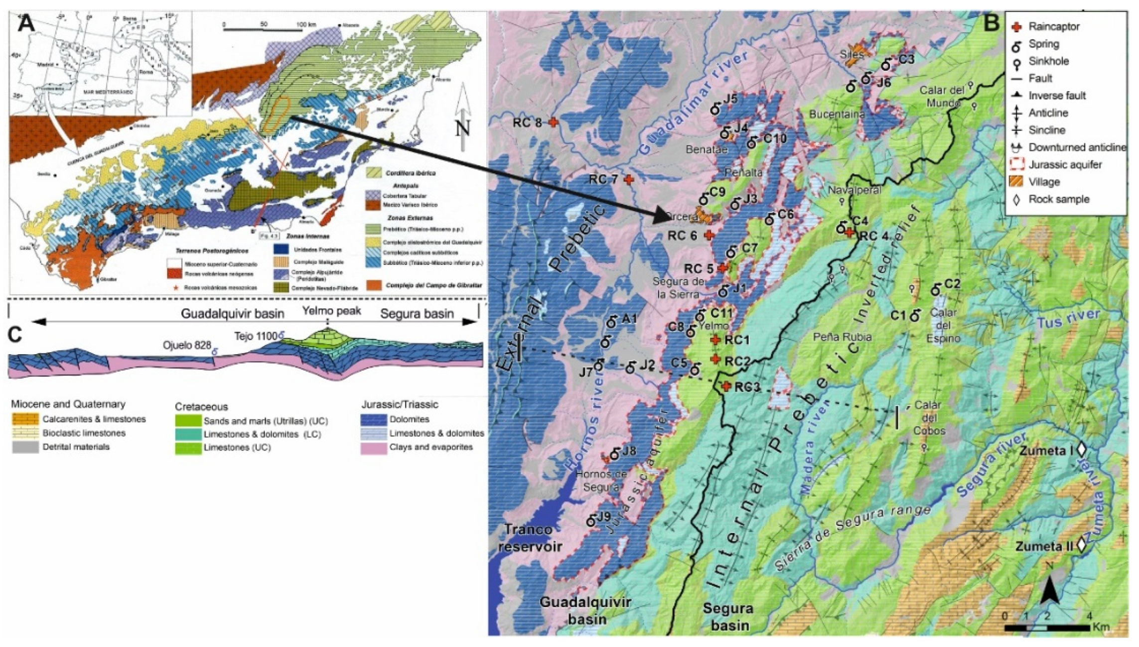
Figure 2.
Temporal analysis of precipitation from 1911 to 2023. Red line: accumulated deviations. Black line: annual deviation. Blue: wet year. Green: average year. Yellow: dry year.
Figure 2.
Temporal analysis of precipitation from 1911 to 2023. Red line: accumulated deviations. Black line: annual deviation. Blue: wet year. Green: average year. Yellow: dry year.
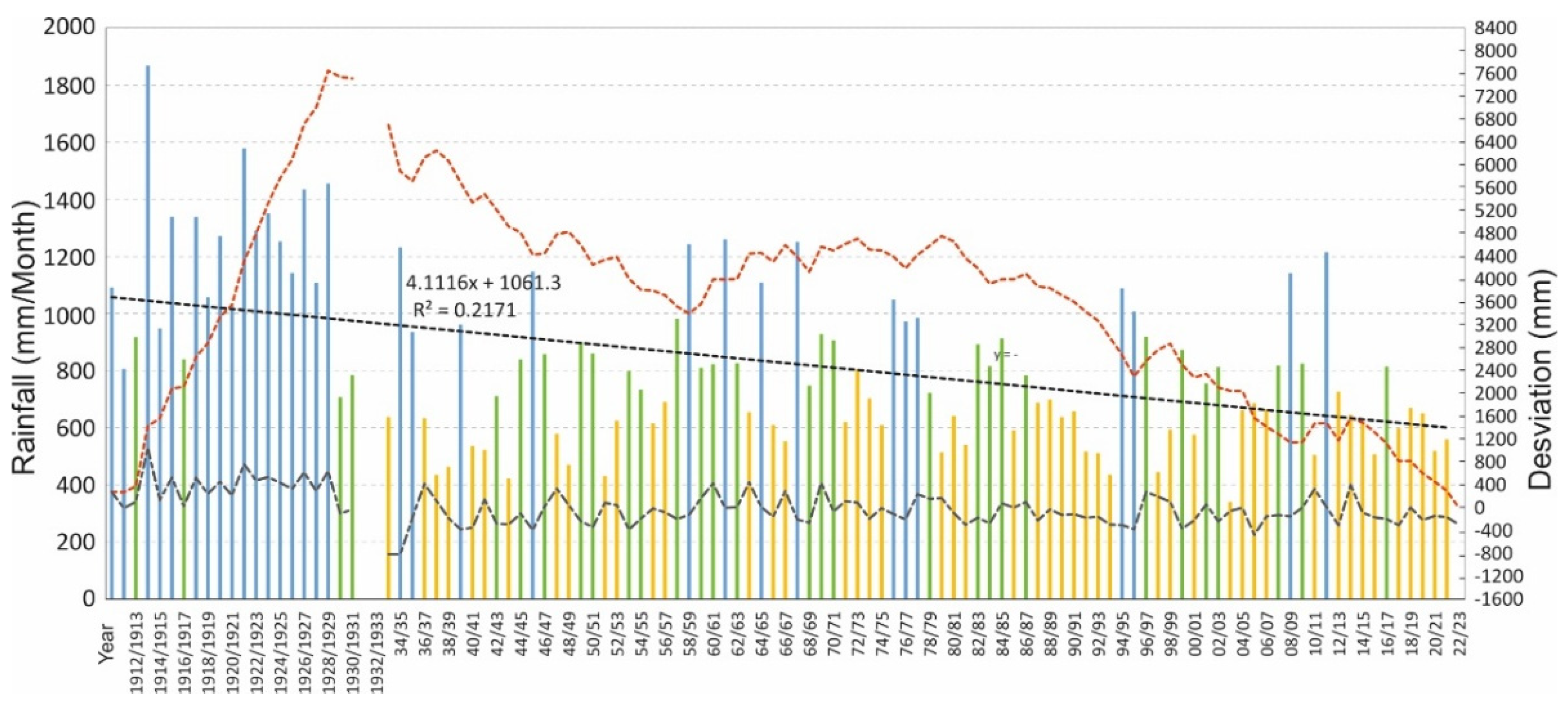
Figure 3.
A: Lower Cretaceous carbonates, B: Jurassic dolomites. C and F: Inverted reliefs of Navalperal and Espino, respectively. D–E–G–H–L–M: Exokarst features. K: Utrillas Formation. I: Fracturing of Jurassic dolomites.
Figure 3.
A: Lower Cretaceous carbonates, B: Jurassic dolomites. C and F: Inverted reliefs of Navalperal and Espino, respectively. D–E–G–H–L–M: Exokarst features. K: Utrillas Formation. I: Fracturing of Jurassic dolomites.
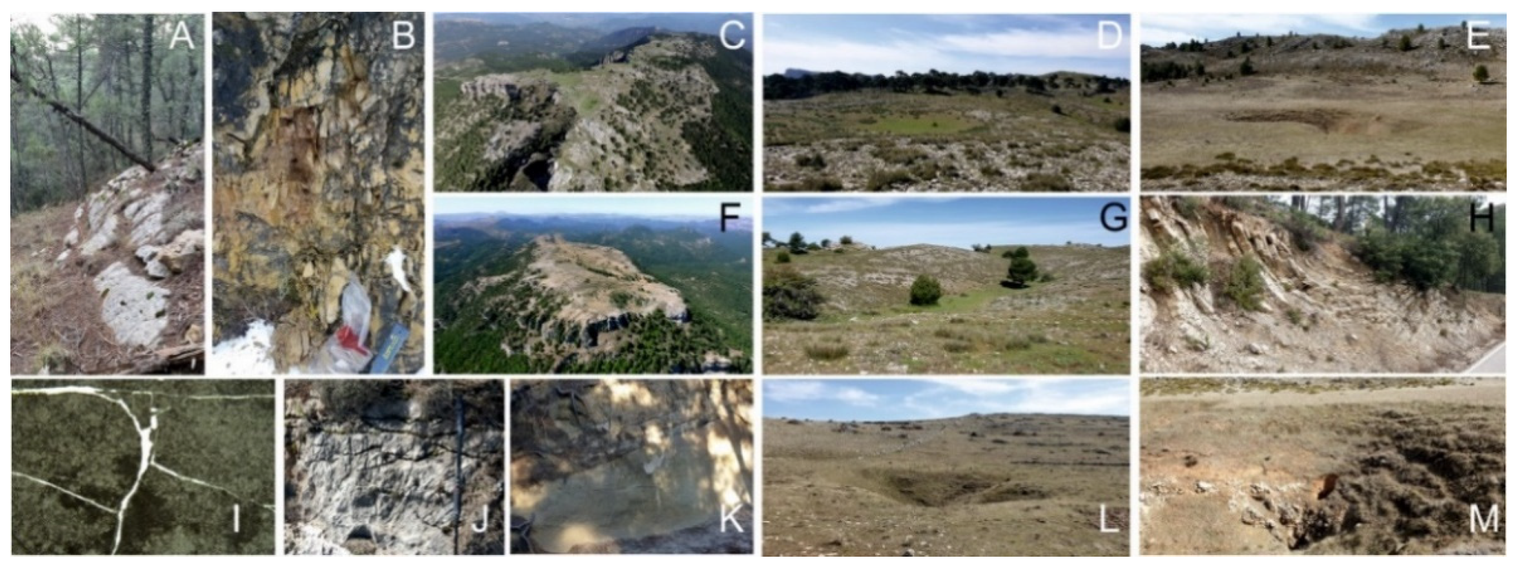
Figure 4.
A) Trilinear diagrams of anions and cations for all the samples. B) Schoeller-Berkaloff diagram of the sample set.
Figure 4.
A) Trilinear diagrams of anions and cations for all the samples. B) Schoeller-Berkaloff diagram of the sample set.
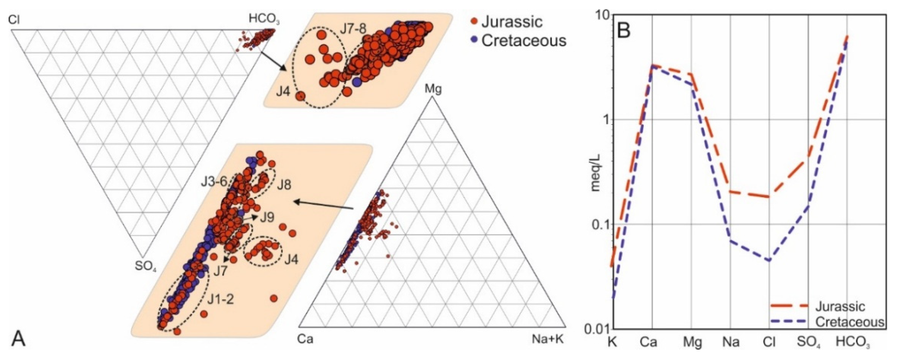
Figure 5.
Hydrochemical relationships (ions in meq/L). A: EC / T . B: HCO3 / pH. C: T / pH. D: T / Mg. Green points: Upper Cretaceous spring. Blue points: Jurassic Springs.
Figure 5.
Hydrochemical relationships (ions in meq/L). A: EC / T . B: HCO3 / pH. C: T / pH. D: T / Mg. Green points: Upper Cretaceous spring. Blue points: Jurassic Springs.
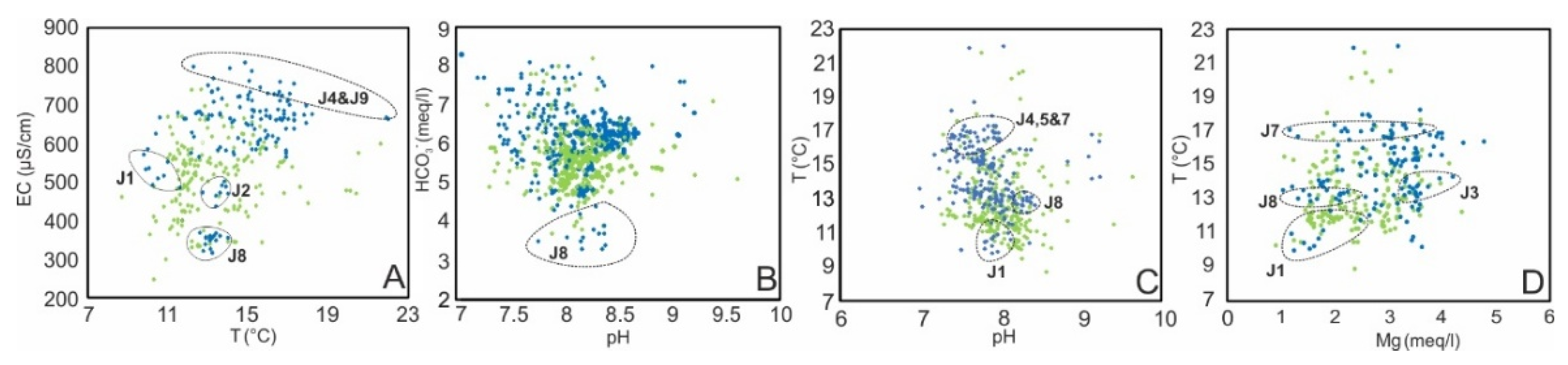
Figure 6.
Ionic relationships: (A) rHCO3 vs. (rCa + rMg); (B) rHCO3 vs. rSO4 ; (C) rCa vs. rMg; (D) rNa vs. rCl; (E) SO4 vs. rCl; (F) rSO4 vs. rNO3. The green points and enclosure indicate Upper Cretaceous springs. The blue points indicate the Jurassic springs. In this case, the dotted box groups data from the same spring, as -indicated within the box.
Figure 6.
Ionic relationships: (A) rHCO3 vs. (rCa + rMg); (B) rHCO3 vs. rSO4 ; (C) rCa vs. rMg; (D) rNa vs. rCl; (E) SO4 vs. rCl; (F) rSO4 vs. rNO3. The green points and enclosure indicate Upper Cretaceous springs. The blue points indicate the Jurassic springs. In this case, the dotted box groups data from the same spring, as -indicated within the box.
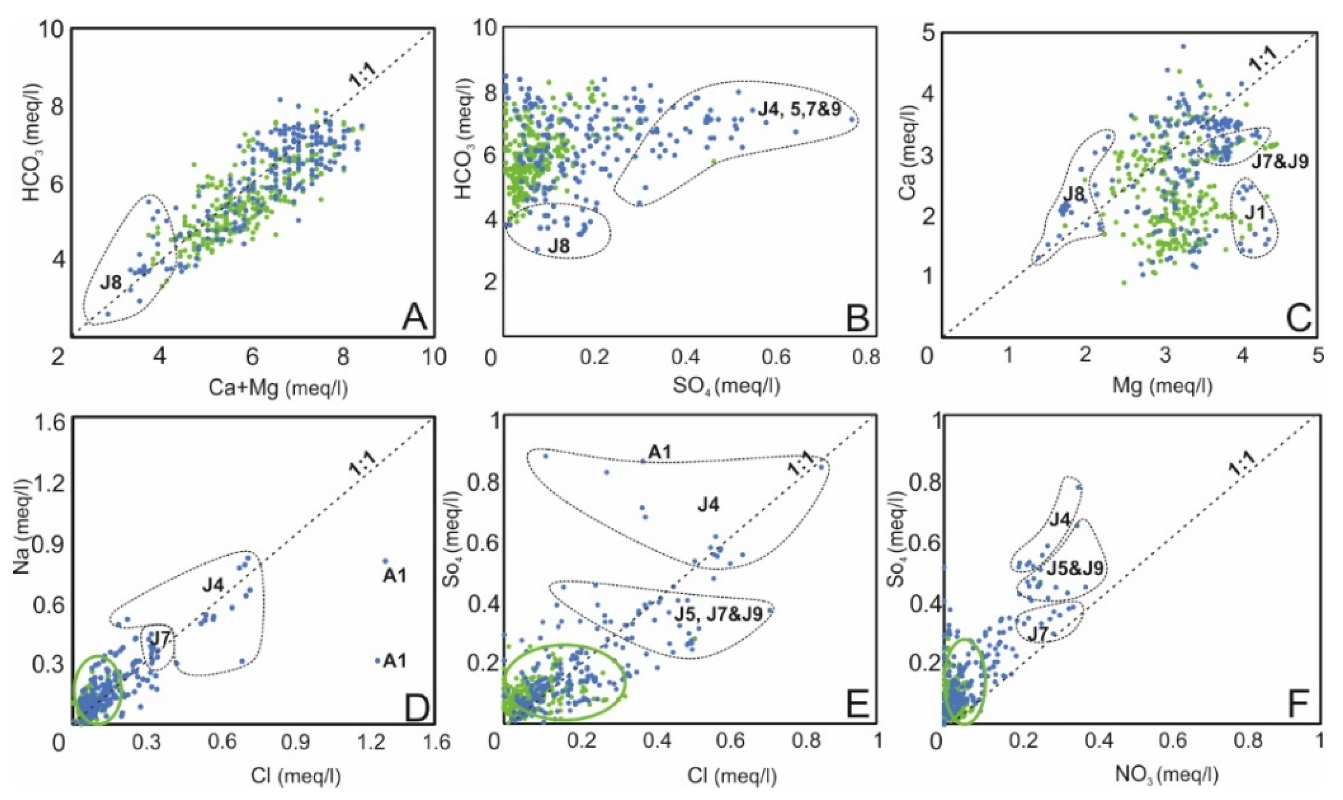
Figure 7.
Principal component analysis (PCA) of the hydrochemical and isotopic dataset. (A) Scores plot in the F1–F2 plane. (B) Loading plot of the first two principal components. (C) Scores and loadings in the F1–F3 plane. Green and purple ellipses delimit the distribution of the Upper Cretaceous and Jurassic groundwater groups, respectively. The solid b arrow represents the conceptual hydrochemical evolution trend, whereas the dashed lines show the projection of the variable vectors onto this conceptual evolution axis to facilitate interpretation of their relative influence. Circled labels highlight springs with distinctive hydrochemical characteristics.
Figure 7.
Principal component analysis (PCA) of the hydrochemical and isotopic dataset. (A) Scores plot in the F1–F2 plane. (B) Loading plot of the first two principal components. (C) Scores and loadings in the F1–F3 plane. Green and purple ellipses delimit the distribution of the Upper Cretaceous and Jurassic groundwater groups, respectively. The solid b arrow represents the conceptual hydrochemical evolution trend, whereas the dashed lines show the projection of the variable vectors onto this conceptual evolution axis to facilitate interpretation of their relative influence. Circled labels highlight springs with distinctive hydrochemical characteristics.
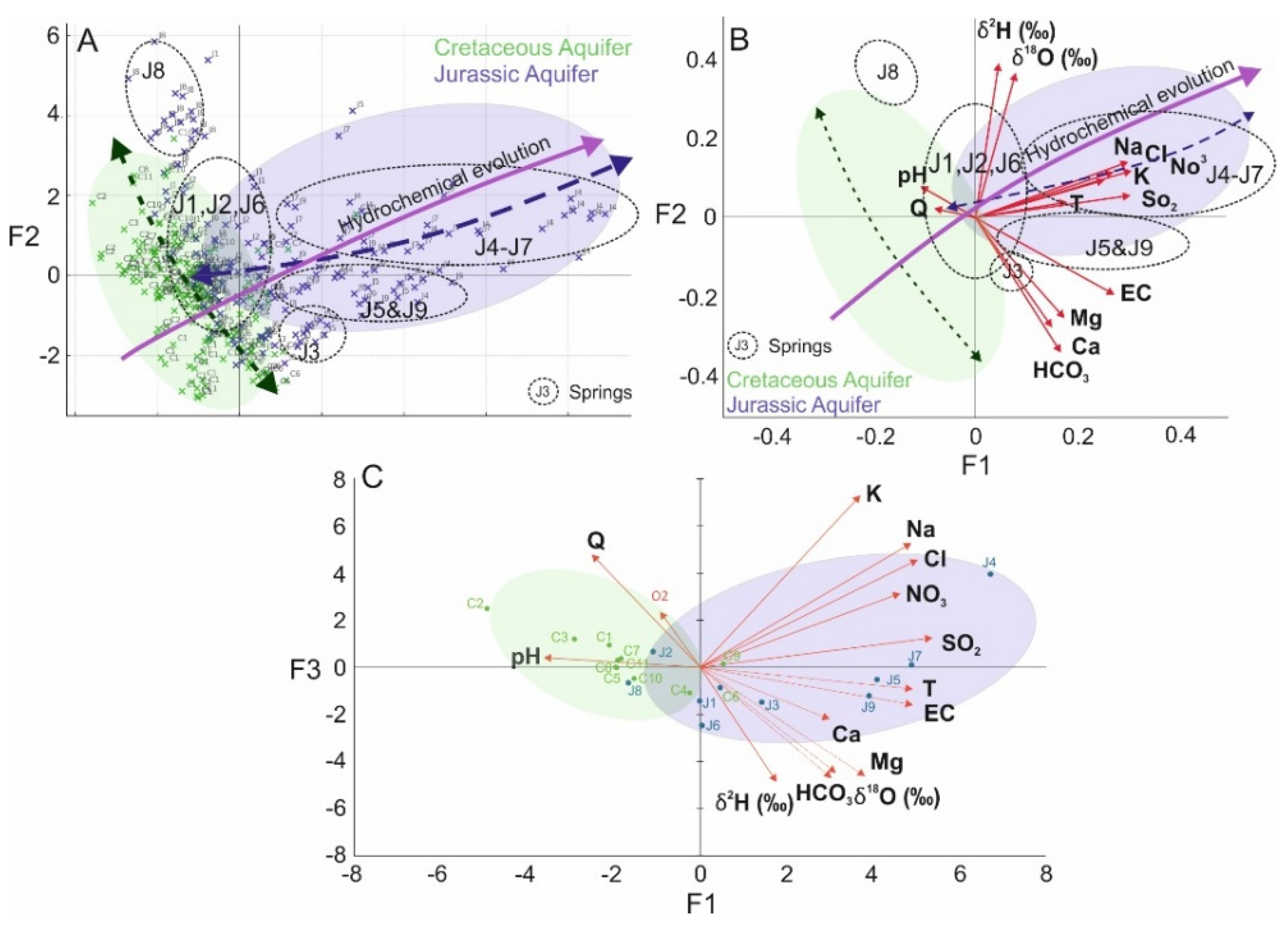
Figure 8.
Temporal evolution of the J2 springs associated with the Jurassic and C2 springs associated with the Cretaceous (δ18O, D-ex, HCO3, Ca, Mg, T, EC, Q, P and δ18O).
Figure 8.
Temporal evolution of the J2 springs associated with the Jurassic and C2 springs associated with the Cretaceous (δ18O, D-ex, HCO3, Ca, Mg, T, EC, Q, P and δ18O).
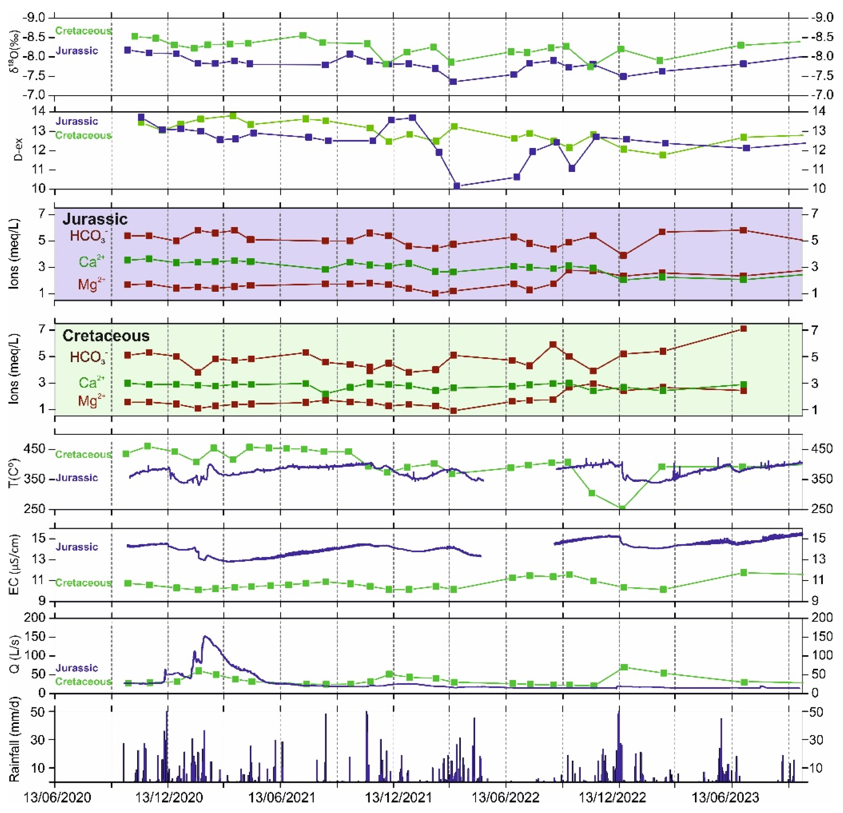
Figure 9.
This conceptual model illustrates how the progressive transfer of recharge from the Upper Cretaceous aquifer to the regional Jurassic aquifer may enhance groundwater storage and sustain groundwater-dependent ecosystems under long-term declining recharge conditions.
Figure 9.
This conceptual model illustrates how the progressive transfer of recharge from the Upper Cretaceous aquifer to the regional Jurassic aquifer may enhance groundwater storage and sustain groundwater-dependent ecosystems under long-term declining recharge conditions.
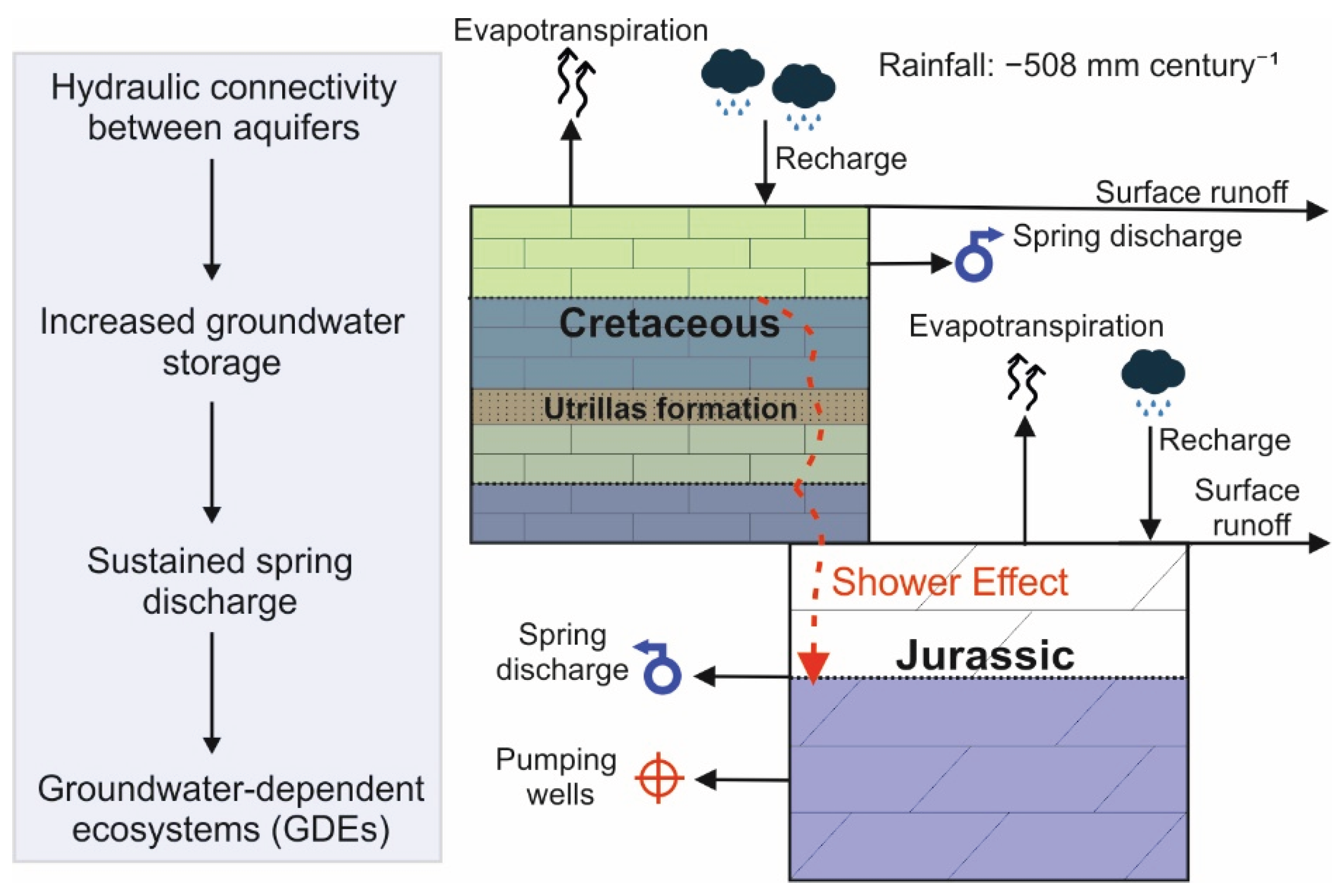

Table 1.
Geographical location, sampling period, and descriptive statistics of the physicochemical, hydrochemical, and isotopic parameters analyzed at the springs of the Upper Cretaceous (C1–C11) and Jurassic (J1–J9) aquifers in Sierra de Segura. The table includes UTM coordinates (ETRS89, zone 30), emergence altitude, number of samples, mean concentrations of the main dissolved ions, redox potential, pH, dissolved oxygen, electrical conductivity, temperature, and flow rate for the period October 2020–October 2023.
Table 1.
Geographical location, sampling period, and descriptive statistics of the physicochemical, hydrochemical, and isotopic parameters analyzed at the springs of the Upper Cretaceous (C1–C11) and Jurassic (J1–J9) aquifers in Sierra de Segura. The table includes UTM coordinates (ETRS89, zone 30), emergence altitude, number of samples, mean concentrations of the main dissolved ions, redox potential, pH, dissolved oxygen, electrical conductivity, temperature, and flow rate for the period October 2020–October 2023.
 |
Disclaimer/Publisher’s Note: The statements, opinions and data contained in all publications are solely those of the individual author(s) and contributor(s) and not of MDPI and/or the editor(s). MDPI and/or the editor(s) disclaim responsibility for any injury to people or property resulting from any ideas, methods, instructions or products referred to in the content. |
© 2026 by the authors. Licensee MDPI, Basel, Switzerland. This article is an open access article distributed under the terms and conditions of the Creative Commons Attribution (CC BY) license (http://creativecommons.org/licenses/by/4.0/).
Copyright: This open access article is published under a Creative Commons CC BY 4.0 license, which permit the free download, distribution, and reuse, provided that the author and preprint are cited in any reuse.