

Submitted:
06 August 2026
Posted:
06 August 2026
You are already at the latest version
Abstract
Remote sensing research increasingly depends on heterogeneous satellite, UAV, hyperspectral, multispectral, SAR, and environmental monitoring data to support land, urban, hydrological, and environmental applications. However, these data are often affected by sensor differences, spatial and temporal heterogeneity, missing observations, irregular sampling, noise, and non-stationary environmental processes. This systematic review was conducted within the context of the Romanian Hub for Artificial Intelligence (HRIA) project, which supports the development of strategic artificial intelligence technologies. The review synthesizes current research on adaptive neural networks for remote sensing and Earth observation, with particular attention to Liquid Neural Networks and related continuous-time neural models. A systematic search was conducted across IEEE Xplore, Scopus, Web of Science, ScienceDirect, SpringerLink, Wiley Online Library, Google Scholar, and reference lists. After duplicate removal, screening, and full-text assessment, 61 studies published between 2018 and 2026 were included in the qualitative synthesis. The findings show that adaptive neural networks have gained increasing attention after 2022 and are mainly applied to image-centered remote sensing tasks, including classification, mapping, object detection, segmentation, enhancement, and change detection. Most studies adapt established deep learning architectures through multi-scale processing, adaptive feature fusion, attention mechanisms, graph relationships, or task-specific refinement. Continuous-time models are used less frequently but are relevant for irregular observations and dynamic environmental processes. Liquid Neural Networks remain emerging, yet show promise for temporal, noisy, multimodal, and nonlinear remote sensing applications.
Keywords:
adaptive neural networks
; liquid neural networks
; continuous-time neural networks
; remote sensing
; Earth observation
; satellite image time series
; systematic literature review
1. Introduction
Remote sensing and Earth observation have become essential to the inventory, monitoring, and management of natural resources, urban systems, agricultural land, water resources, hazards, and environmental change. Modern acquisition systems provide large volumes of optical, multispectral, hyperspectral, Synthetic Aperture Radar (SAR), Unmanned Aerial Vehicle (UAV), and environmental monitoring data, supporting applications such as land use and land cover mapping, precision agriculture, disaster assessment, hydrological monitoring, urban analysis, and climate-related studies [1,2,3,4]. These data are increasingly complemented by high-resolution aerial observations and multimodal acquisition strategies that combine spatial, spectral, thermal, and temporal information [5,6].
Despite these advances, applied Earth observation remains methodologically challenging because geospatial data are rarely homogeneous. Remote sensing observations combine spatial, spectral, temporal, and contextual information, while also being affected by atmospheric disturbances, clouds, shadows, sensor differences, temporal gaps, noisy labels, missing observations, and domain shifts across geographic regions and acquisition conditions [7,8,9]. Satellite image time series are particularly difficult to model because observations are often irregularly sampled and influenced by seasonal variability, changing land-surface conditions, and sensor-specific constraints [10,11,12]. Many applied geoinformation tasks also face limited reference data, imbalanced classes, and incomplete ground truth, which can reduce model reliability and transferability [13,14].
Machine learning and deep learning methods have been widely adopted to address these challenges in remote sensing and geospatial analysis. Classical models such as Random Forests and Support Vector Machines remain important for classification and regression, while deep learning architectures have improved performance in scene classification, semantic segmentation, object detection, change detection, image enhancement, and time-series analysis [7,15,16,17]. Convolutional Neural Networks (CNN) are commonly used for spatial feature extraction, recurrent models for temporal sequences, and Transformer-based models for long-range dependencies [10,18]. However, conventional deep learning models may struggle with irregular sampling, missing observations, noisy inputs, limited training data, domain shifts, and non-stationary environmental processes, which are frequent in real-world Earth observation applications [9,13,19].
However, conventional deep learning models still present important limitations when applied to complex and dynamic geospatial data. CNNs are effective for spatial representation learning, but they require additional mechanisms for temporal dynamics. Recurrent models process sequences in discrete time and may struggle with irregular sampling, missing observations, and long-term dependencies. Transformer-based models can capture long-range dependencies, but they are often computationally demanding and data intensive [8,20]. More broadly, many models remain sensitive to noise, limited training data, domain shifts, and non-stationary environmental processes, which are frequent in real-world Earth observation and geoinformation applications [9,13,19].
In this context, adaptive neural networks represent an important methodological direction for remote sensing and Earth observation. In this review, adaptive neural networks are understood as neural models that adjust their internal representations, feature weighting, temporal dynamics, graph relationships, parameters, or learning behavior in response to data variability, task requirements, or changing environmental conditions. This broad category includes adaptive convolutional models, attention-based architectures, graph-based models, adaptive fusion methods, neural differential equation models, and other dynamic learning approaches. Such methods are particularly relevant for applied remote sensing because they can improve robustness, contextual representation, and temporal modeling capacity in heterogeneous and uncertain geospatial environments [21,22,23,24].
Among adaptive neural approaches, Liquid Neural Networks (LNN) and related continuous-time neural models are especially relevant because they introduce a dynamic modeling paradigm in which hidden states evolve continuously over time. Liquid Time-Constant Networks, Neural Circuit Policies, Closed-form Continuous-time models, and Neural Ordinary Differential Equation-based architectures provide mechanisms for representing temporal evolution, irregular sampling, and nonlinear system dynamics [25,26,27,28]. These characteristics are conceptually aligned with many Earth observation problems, including satellite image time series, environmental monitoring, flood prediction, landslide susceptibility assessment, change detection, and dynamic urban analysis.
Nevertheless, the use of Liquid Neural Networks in geospatial research remains limited. While adaptive CNNs, attention-based models, graph-based architectures, and fusion strategies are increasingly visible in remote sensing, only a small number of recent studies have explicitly explored Liquid Neural Networks or closely related continuous-time models in Earth observation and geoinformation applications [24,29,30,31,32,33]. Therefore, the relevant research gap is not the absence of adaptive methods in geospatial data analysis, but rather the limited and fragmented adoption of LNN-based and continuous-time approaches within this broader adaptive-neural-network landscape. A second gap concerns the quality of evidence because reported improvements are often difficult to compare because studies differ in datasets, baselines, validation protocols, ablation analyses, robustness testing, and computational reporting.
Developed within the context of the Romanian Hub for Artificial Intelligence (HRIA) project, which supports the development of strategic artificial intelligence technologies, this study provides a systematic literature review of adaptive neural networks for remote sensing and Earth observation. The review aims to synthesize the current state of research, identify the geospatial data types and application domains addressed, categorize the adaptive neural approaches used, and determine the extent to which Liquid Neural Networks and related continuous-time models have been adopted in remote sensing applications. Beyond descriptive mapping, the review also assesses the methodological quality, risk of bias, and strength of evidence of the included studies in order to evaluate whether reported performance gains are credible, reproducible, and comparable across tasks. By combining a taxonomy of adaptive neural approaches with an evidence-oriented appraisal, this review identifies not only current trends, but also the methodological limitations, validation gaps, and future research needs for adaptive and continuous-time modeling in Earth observation.
2. Background and Theoretical Framework
2.1. Remote Sensing Data and Challenges
Earth observation data differ from conventional image data because they combine spatial, spectral, temporal, and geographic information. Satellite, UAV, hyperspectral, multispectral, and SAR observations provide complementary views of the Earth’s surface and support applications such as land cover mapping, crop monitoring, disaster assessment, hydrological analysis, urban monitoring, and environmental change detection [1,2,3,34]. However, these data also introduce specific modeling challenges. Optical imagery is affected by clouds, shadows, atmospheric conditions, and illumination variability; SAR data are affected by speckle and sensor-specific acquisition geometry; hyperspectral data contain high-dimensional spectral information; and satellite image time series often include irregular temporal gaps, missing observations, and seasonal variability [7,8,17].
In applied remote sensing tasks, these technical issues are combined with limited reference data, noisy labels, class imbalance, geographic domain shifts, and differences between sensors, regions, and acquisition periods. These factors reduce the transferability of models trained on a single dataset or study area and make robust Earth observation modeling difficult. Recent work has emphasized the need for methods that can handle small training datasets, uncertainty, and explainability in remote sensing applications [13,19]. These characteristics motivate the use of adaptive neural models that can respond to spatial, spectral, temporal, and sensor-related variability rather than relying only on fixed representations.
2.2. Deep Learning and Adaptivity
Deep learning has become widely used in remote sensing because it can learn hierarchical representations directly from large and heterogeneous Earth observation datasets. CNNs have been used for spatial feature extraction, image classification, segmentation, object detection, and change detection, while recurrent networks and temporal convolutional models have been used for satellite image time series [7,10,17]. Transformer-based models have also been introduced to capture long-range dependencies, although their computational cost and data requirements can limit their use in some applied settings [12,20].
Despite these advantages, conventional deep learning architectures are not always well aligned with the properties of Earth observation data. CNNs are effective for spatial patterns but do not inherently model temporal dynamics. RNNs and LSTMs process sequences in discrete time and may be sensitive to irregular sampling or missing observations. Transformers can represent long-range relationships, but they often require large training datasets and substantial computational resources. These limitations are important in geoinformation applications where data may be incomplete, noisy, spatially heterogeneous, or collected under changing environmental conditions [8,9,13].
Adaptive neural networks address these limitations by modifying the way models select, fuse, weight, or evolve information. In remote sensing, adaptivity can be introduced through multi-scale convolution, attention mechanisms, adaptive feature fusion, deformable operations, graph-based spatial relationships, or dynamic temporal modeling. Such approaches are useful when objects appear at different spatial scales, spectral responses vary across sensors, temporal observations are irregular, or multimodal data sources must be integrated. Examples include adaptive CNN-based segmentation [21], multi-scale object detection [22], spatio-temporal attention modeling [23], and graph-based or multimodal adaptive geospatial prediction [24,35]. Within this broader group, continuous-time models and Liquid Neural Networks represent a more specific direction focused on dynamic state evolution.
Adaptive neural networks address these limitations by modifying the way models select, fuse, weight, or evolve information. In remote sensing, adaptivity can be introduced through multi-scale representation learning, attention mechanisms, adaptive feature fusion, spatial relationship modeling, or dynamic temporal modeling [7,20]. These approaches are useful when objects appear at different spatial scales, spectral responses vary across sensors, temporal observations are irregular, or multimodal data sources must be integrated [8,12]. Within this broader group, continuous-time models and Liquid Neural Networks represent a more specific direction focused on dynamic state evolution and irregular temporal modeling [25,28].
2.3. LNNs and Continuous-Time Models
Liquid Neural Networks are adaptive continuous-time neural models designed to represent dynamic processes through evolving hidden states. Liquid Time-Constant Networks use input-dependent time constants, allowing the model to adapt its temporal response according to the current input and internal state [25]. Related models, including Neural Circuit Policies and Closed-form Continuous-time networks, show that compact continuous-time architectures can model temporal dynamics while maintaining relatively efficient representations [26,27]. Neural Ordinary Differential Equations and related continuous-time models provide a broader mathematical framework for learning hidden-state evolution in continuous time [36,37].
These properties are relevant for Earth observation because many geospatial processes are dynamic, irregularly observed, and affected by missing or noisy measurements. Satellite revisit intervals, cloud contamination, asynchronous environmental measurements, seasonal variation, and non-stationary land-surface processes can make fixed-step temporal modeling inadequate. Continuous-time models are therefore conceptually suitable for satellite image time series, environmental forecasting, hydrological monitoring, change detection, landslide susceptibility assessment, and urban prediction.
Although the theoretical fit is strong, the extent to which LNNs and related continuous-time models have been adopted in geospatial research remains unclear. This motivates a systematic review of adaptive neural networks in remote sensing and Earth observation, with particular attention to the current position and future potential of Liquid Neural Networks.
3. Methodology
This systematic literature review was conducted to identify and synthesize studies on adaptive neural networks in remote sensing and Earth observation, with particular attention to Liquid Neural Networks and related continuous-time neural models. The review followed the Preferred Reporting Items for Systematic Reviews and Meta-Analyses (PRISMA) framework [38] to support transparency and reproducibility.
3.1. Search Strategy and Data Sources
A systematic search was conducted across IEEE Xplore, Scopus, Web of Science, ScienceDirect, SpringerLink, and Wiley Online Library. These databases were selected because they provide broad coverage of artificial intelligence, remote sensing, geoinformation, Earth observation, and environmental data analysis research. The database search was complemented by targeted searches in Google Scholar and by manual screening of reference lists from relevant papers.
The search strategy combined two groups of terms. The first group captured adaptive and continuous-time neural models, including terms such as “adaptive neural network”, “dynamic neural network”, “liquid neural network”, “liquid time-constant network”, “continuous-time neural network”, “neural ordinary differential equation”, “neural differential equation”, “latent ODE”, and “ODE-RNN”. The second group captured Earth observation and geospatial applications, including terms such as “remote sensing”, “earth observation”, “geospatial data”, “satellite imagery”, “hyperspectral”, “multispectral”, “synthetic aperture radar”, “SAR”, and “UAV imagery”. The search strings were adapted to the syntax of each database, and the complete search queries are provided in Supplementary Materials.
3.2. Eligibility Criteria
Studies were included if they met the following criteria: they addressed remote sensing, Earth observation, satellite, UAV, hyperspectral, multispectral, SAR, environmental monitoring, or related geospatial data; they used a neural network architecture with an adaptive, dynamic, temporal, attention-based, graph-based, fusion-based, continuous-time, or Liquid Neural Network component; they reported a methodological contribution, experiment, or application relevant to geospatial data analysis; they were written in English; and they were peer-reviewed journal articles or conference papers published from 2015 onwards.
Studies were excluded if they did not involve geospatial or remote sensing data, did not use neural network-based methods, focused only on conventional machine learning without an adaptive neural component, lacked sufficient methodological detail, or were outside the scope of Earth observation and geoinformation. Editorials, theses, patents, book chapters, posters, abstracts, and non-peer-reviewed documents were also excluded.
3.3. Screening and Study Selection
All retrieved records were exported and merged into a single reference library. Duplicate records were removed before screening. The remaining studies were first screened by title and abstract to exclude clearly irrelevant records. Full texts were then assessed for eligibility according to the inclusion and exclusion criteria. Studies were retained only when they presented a relevant geospatial application and a neural architecture containing an adaptive, dynamic, or continuous-time component.
The study selection process followed the PRISMA workflow, including identification, duplicate removal, title and abstract screening, full-text assessment, and final inclusion. The number of records retained and excluded at each stage is reported in the PRISMA flow diagram in Section 4.1.
3.4. Data Extraction and Qualitative Synthesis
For each included study, information was extracted on publication year, data type, sensor or data source, application domain, model architecture, adaptive mechanism, datasets, evaluation metrics, reported performance, advantages, and limitations. The extracted studies were then categorized according to three main dimensions: geospatial data type, application domain, and neural modeling approach.
The qualitative synthesis focused on identifying methodological trends across adaptive neural network families, including adaptive CNNs, attention-based models, graph-based models, adaptive fusion strategies, Neural ODEs, continuous-time neural models, and Liquid Neural Networks. Because the included studies differed substantially in datasets, tasks, metrics, and baseline models, a quantitative meta-analysis was not performed. Instead, the synthesis emphasizes recurring patterns, reported benefits, methodological limitations, and research gaps relevant to adaptive and continuous-time modeling in applied Earth observation and geoinformation.
3.5. Methodological Quality and Evidence Assessment
To move beyond a descriptive taxonomy, the included studies were also assessed for methodological quality, risk of bias, and strength of evidence. The assessment focused on whether reported performance gains for adaptive neural networks were credible, reproducible, and comparable across Earth observation and geoinformation tasks. Because the reviewed literature covered heterogeneous remote sensing applications rather than clinical or intervention studies, a domain-specific appraisal rubric was used instead of a standard medical risk-of-bias tool.
Each study was evaluated across eight criteria: dataset and sensor transparency, clarity of reference labels or ground truth, adequacy of baseline comparisons, validation design, ablation analysis of the adaptive component, robustness or generalization testing, completeness of evaluation metrics, and reporting of computational or reproducibility details. Each criterion was scored as 0 when not reported or insufficiently addressed, 1 when partially addressed, and 2 when clearly addressed. This produced a maximum methodological quality score of 16 for each study.
Based on the total score and the presence of key methodological safeguards, studies were categorized as having high, moderate, or limited methodological support. Studies with high support used clearly described datasets, appropriate baselines, meaningful validation, and evidence that the adaptive component contributed to the reported performance. Studies with moderate support reported relevant experiments but had limitations such as restricted baselines, single-dataset evaluation, incomplete ablation, or limited robustness testing. Studies with limited support lacked one or more major elements needed to judge the credibility or reproducibility of the reported gains.
Risk of bias was assessed qualitatively from the same criteria. Higher risk was assigned to studies with unclear data sources, weak or missing baselines, single-region or single-split validation, no ablation analysis, limited metric reporting, or insufficient implementation details. Evidence strength was then summarized at the level of model families, considering the number of studies, methodological support, consistency of reported improvements, comparability of datasets and metrics, and reporting of computational trade-offs. This assessment was used to distinguish between well-supported trends and preliminary findings, particularly for Liquid Neural Networks and other continuous-time models, where the number of Earth observation studies remains limited.
4. Results
4.1. Study Selection and Characteristics
The systematic search identified 941 records, including 744 records from scientific databases (IEEE Xplore, Scopus, Web of Science, ScienceDirect, SpringerLink, and Wiley Online Library) and 197 additional records from Google Scholar and manual reference-list screening. After removing 206 duplicate records, 735 records remained for title and abstract screening. During this stage, 641 records were excluded because they did not address Earth observation, remote sensing, or geoinformation data, did not use neural network-based methods, focused only on conventional machine learning, or did not include an adaptive, dynamic, temporal, attention-based, graph-based, fusion-based, continuous-time, or related neural component.
The remaining 94 articles were retrieved and assessed in full text. Following full-text assessment, 33 studies were excluded because they did not sufficiently address adaptive neural networks in geospatial data, lacked methodological detail, did not include a relevant Earth observation or geoinformation application, were inaccessible, or did not meet the publication-type criteria. Finally, 61 studies met all eligibility criteria and were included in the qualitative synthesis. The complete study selection process is summarized in Figure 1.
The final corpus included studies published between 2018 and 2026. Although the search covered publications from 2015 onwards, no studies from 2015–2017 met the final eligibility criteria, confirming that adaptive neural networks are a recent research direction in Earth observation and geoinformation. Publication activity increased notably after 2022, with 52 of the 61 included studies published between 2022 and 2026. The highest number of studies was observed in 2025, followed by 2026 and 2024; however, the 2026 count should be interpreted cautiously because the search period did not cover a complete publication year. This temporal distribution suggests that adaptive neural networks have gained visibility as remote sensing research has moved toward larger datasets, multimodal observations, satellite image time series, and more complex geospatial learning tasks.
The early included studies mainly focused on adaptive convolutional architectures, adaptive network structures, and remote sensing image classification or segmentation. Examples include adaptive neural networks for vegetation biomass estimation [39], adaptive CNN structures for hyperspectral image classification [40], adaptive tree convolutional networks for aerial image segmentation [41], and adaptive neural approaches for pansharpening of PAN and multispectral images [42]. From 2022 onwards, the scope became broader, with studies addressing neural differential equations for Earth observation data [43], adaptive spatio-temporal modeling [23], multi-scale architectures [22], attention-based mechanisms [44], and dynamic or time-variant neural network designs [45].
The most recent studies show further diversification toward application-driven geoinformation problems. Publications from 2024 to 2026 include adaptive models for satellite image segmentation [21], oriented object detection in remote sensing images [46], SAR ship detection [47,48], remote sensing image dehazing [49,50], building extraction [51], UAV-based analysis [52,53], hyperspectral image processing [31,54], and satellite image time-series reconstruction [55]. This period also contains most of the studies involving Liquid Neural Networks or closely related continuous-time models, including satellite image classification [29], hyperspectral image classification [30,31], landslide susceptibility assessment [24], and remote sensing change detection [33]. These patterns show that LNN-based approaches are emerging within a broader and rapidly diversifying adaptive neural network landscape.
4.2. Geospatial Data Types and Sources
The included studies covered a diverse set of Earth observation and geoinformation data sources, ranging from optical and multispectral satellite imagery to hyperspectral data, SAR imagery, UAV observations, environmental time series, and multimodal geospatial data. Table 1 summarizes the distribution of studies by primary data type or source. The distribution shows that adaptive neural networks are not limited to a single sensor type or application setting, but are being explored across multiple forms of spatial, spectral, and temporal data used in applied remote sensing.
As shown in Table 1, optical, multispectral, and general remote sensing imagery represented the largest data group. These studies addressed image-centered problems such as satellite image segmentation, land-cover mapping, object detection, building extraction, image dehazing, super-resolution, and pansharpening [21,22,46,50,51,56,57]. This pattern indicates that adaptive neural networks are most frequently used where spatial structure, object scale, scene heterogeneity, and image quality directly influence downstream information extraction. Environmental and Earth observation time series formed the second largest group. These studies included crop classification under cloud cover, Landsat time-series reconstruction, precipitation nowcasting, flood and wind-speed prediction, drought forecasting, and water-quality anomaly detection [32,55,58,59,60,61]. This group is particularly relevant to adaptive and continuous-time modeling because it involves irregular observations, temporal gaps, nonlinear environmental dynamics, and non-stationary processes.
The remaining categories in Table 1 show the spread of adaptive neural approaches across more specialized Earth observation data sources. Hyperspectral studies mainly focused on hyperspectral image classification, spectral–spatial feature modeling, hyperspectral super-resolution, and modeling atmospheric effects [31,40,54,62,63,64]. SAR-based studies addressed change detection, moving target tracking, ship detection, and target recognition [44,47,48,65,66,67].
UAV and aerial studies covered aerial segmentation, weed detection, UAV object detection, disaster inspection, and trajectory prediction [41,52,53,68,69,70]. Multimodal studies combined complementary sources such as optical imagery, InSAR deformation time series, precipitation data, active–passive remote sensing, and aerial–ground observations [24,71,72,73].
Overall, the data-source distribution indicates that adaptive neural networks are currently most established in image-centered remote sensing, especially optical and multispectral imagery. At the same time, the presence of environmental time series, hyperspectral data, SAR imagery, UAV observations, and multimodal fusion studies shows that adaptive modeling is expanding toward more complex geoinformation settings. These data types introduce challenges related to spectral dimensionality, temporal irregularity, sensor noise, spatial scale variation, and multimodal integration, which are closely aligned with the motivations for adaptive and continuous-time neural approaches.
4.3. Application Domains and Remote Sensing Tasks
The reviewed studies addressed a wide range of remote sensing and Earth observation tasks, from image interpretation and object extraction to environmental prediction and multimodal urban analysis. Table 2 summarizes the distribution of included studies by dominant application domain or remote sensing task. The distribution shows that adaptive neural networks are currently most visible in tasks where spatial structure, scale variation, sensor noise, and heterogeneous scene content directly affect the quality of extracted remote sensing information.
As shown in Table 2, classification and mapping formed the largest application group. These studies included hyperspectral image classification, satellite image classification, crop classification under cloud cover, and land-cover or land-use mapping [29,40,56,58,62]. This pattern is consistent with the long-standing role of classification in applied remote sensing, but the reviewed studies show a shift from fixed feature extraction toward adaptive mechanisms that can better capture spectral variability, spatial context, temporal gaps, and heterogeneous land-surface patterns.
Object and target detection, tracking, and recognition formed another major application group. Adaptive neural networks were used for multi-scale object detection, oriented object detection in remote sensing images, UAV-based object detection, SAR ship detection, SAR target recognition, and moving target tracking [22,46,47,48,53,66,67,68]. These applications connect neural modeling with operational geoinformation tasks, where object size, orientation, background clutter, imaging geometry, and sensor-specific noise can strongly influence detection reliability.
Environmental, hydrological, and meteorological prediction represented a distinct group of studies in which adaptive and continuous-time models were used to represent dynamic processes rather than only static image patterns. The reviewed applications included vegetation biomass estimation, precipitation nowcasting, flood prediction, drought forecasting, landslide susceptibility assessment, wind-speed prediction, and water-quality anomaly detection [24,32,39,59,60,61]. This group is important because it shows how adaptive neural networks can support environmental monitoring and decision-support tasks involving temporal variability, nonlinear dynamics, missing observations, and non-stationary processes.
Image restoration, reconstruction, fusion, and enhancement studies focused on improving the quality, completeness, or usability of Earth observation data before downstream analysis. These tasks included pansharpening, hyperspectral super-resolution, remote sensing image dehazing, infrared and visible image fusion, and Landsat time-series reconstruction [42,49,50,55,57,74]. In these studies, adaptivity was mainly used to handle sensor degradation, missing information, atmospheric effects, frequency-domain differences, or complementary information from multiple data sources.
Segmentation and extraction studies addressed tasks such as satellite image segmentation, aerial image segmentation, building extraction, weed detection, and semantic segmentation [21,41,51,52,75,76]. These applications require accurate spatial delineation and are sensitive to boundary complexity, object scale, scene heterogeneity, and class imbalance. Adaptive architectures were therefore used to refine spatial representations, combine multi-scale information, or improve feature selection in complex scenes.
The smaller task groups in Table 2 show that adaptive neural networks are also expanding into urban, infrastructure, multimodal, and change-monitoring applications. Urban and cross-view studies addressed vehicle trajectory prediction, parking violation detection, urban waterlogging, road infrastructure monitoring, and aerial–ground matching [35,70,72,73,77]. Change detection studies focused on SAR or remote sensing change analysis, including geometric attention, multi-scale attention, and LNN-based change detection [33,65,78,79]. Although these categories were less frequent, they are important because they indicate a gradual movement from single-image interpretation toward dynamic, multimodal, and decision-oriented geoinformation applications.
Overall, the task distribution suggests that adaptive neural networks are currently strongest in image-centered Earth observation workflows, but their relevance is expanding toward environmental prediction, data reconstruction, urban analysis, and change monitoring. These applications reflect the practical challenge of converting heterogeneous Earth observation data into reliable remote sensing products for monitoring, planning, risk assessment, and environmental decision support.
4.4. Taxonomy of Adaptive Approaches
The reviewed studies show that adaptive neural networks in remote sensing and Earth observation do not form a single model family. Instead, adaptivity appears as a modeling principle implemented through different architectural mechanisms, depending on the data source, spatial scale, temporal structure, sensor characteristics, and application objective. Figure 2 summarizes the representative workflow observed across the included studies, from heterogeneous Earth observation inputs to preprocessing, adaptive representation learning, task-specific prediction, and validation. The figure also highlights that adaptivity can be introduced at different stages of the remote sensing pipeline, including feature extraction, temporal modeling, multimodal fusion, graph-based representation, and continuous-time state evolution.
Based on the reviewed studies, five major adaptive modeling families were identified: adaptive CNN and multi-scale models, attention-based models, graph-based and relational models, adaptive fusion and restoration models, and continuous-time or Liquid Neural Network-based models. Table 3 summarizes these families according to their main adaptive mechanism, the Earth observation challenge they address, and representative application areas.
Adaptive CNN and multi-scale architectures represented the most established form of adaptivity in the reviewed literature. These models extend traditional convolutional networks by introducing scale-aware feature extraction, deformable sampling, adaptive aggregation, or refinement modules. Such mechanisms are well suited to Earth observation imagery, where objects and land-surface patterns vary substantially in size, shape, texture, and spatial context. Examples include adaptive CNN structures for hyperspectral image classification [40], multi-scale models for remote sensing object detection [22], satellite image segmentation [21], building extraction [51], and UAV-based detection or inspection tasks [53,68]. In these studies, adaptivity is mainly used to improve spatial representation and reduce sensitivity to scale variation and heterogeneous scene content.
Attention-based models formed a second important group. Their main role is to assign different weights to spatial regions, spectral bands, temporal observations, channels, or contextual relationships. This is particularly useful in remote sensing because relevant information is often distributed unevenly across the image, while irrelevant background, atmospheric effects, shadows, or sensor noise can reduce model reliability. Attention mechanisms were used in applications such as adaptive spatio-temporal modeling [23], SAR-based shadow or moving-target analysis [44], change detection [79], and semantic or spectral–spatial representation learning [64,76]. These studies show that attention-based adaptivity is most useful when the model must select informative features from complex spatial, spectral, or temporal contexts.
Graph-based and relational adaptive models addressed a different type of geospatial challenge. Instead of focusing only on pixel-level or patch-level features, these models represent relationships between locations, objects, regions, or data modalities. This is relevant for urban systems, infrastructure monitoring, landslide susceptibility assessment, and cross-view geoinformation tasks, where spatial dependency and contextual relationships influence the target variable. Examples include adaptive graph-based modeling for urban waterlogging [35], multimodal road infrastructure analysis [72], aerial–ground cross-view matching [73], and graph-enhanced liquid modeling for landslide susceptibility assessment [24]. In these cases, adaptivity is linked to relational structure rather than only to local image features.
Adaptive fusion, restoration, and reconstruction models were used when the main challenge was not only prediction, but also improving the quality or completeness of Earth observation data. These studies addressed pansharpening, hyperspectral super-resolution, image dehazing, infrared–visible image fusion, and satellite time-series reconstruction [42,49,50,55,57,74]. The adaptive component usually acted as a mechanism for combining complementary information, compensating for degradation, reconstructing missing observations, or aligning data with different spatial, spectral, or temporal properties. This family is important for applied geoinformation because the quality of downstream mapping, detection, and monitoring tasks often depends on the reliability of the input data.
Liquid Neural Networks and Continuous-time models formed the most specific adaptive family identified in this review. Neural ODE-based methods model hidden-state evolution as a continuous process, which is relevant for irregularly sampled satellite observations, cloud-related gaps, environmental time series, and dynamic land-surface processes. The reviewed studies applied continuous-time modeling to crop classification under cloud cover [58], Earth observation dynamics [43], precipitation nowcasting [59], and hyperspectral feature evolution [54]. LNN-based studies extended this direction by introducing adaptive internal dynamics and input-dependent temporal responses, with applications in satellite image classification [29], hyperspectral image classification [30,31], flood prediction [32], landslide susceptibility assessment [24], and remote sensing change detection [33]. In several of these studies, LNNs or LNN-inspired architectures reported improvements over conventional baseline models and the need of less parameters [32,60], suggesting that adaptive continuous-time dynamics may provide advantages when geospatial data are irregular, noisy, temporally variable, or governed by nonlinear environmental processes. However, these results should be interpreted as early evidence rather than definitive proof of general superiority, because the current LNN literature remains recent, task-specific, and heterogeneous in terms of datasets, baselines, and evaluation protocols.
Taken together, this taxonomy shows that adaptivity in EO can be grouped into three main dimensions: spatial adaptivity for scale, shape, and context; spectral and multimodal adaptivity for sensor complementarity and feature relevance; and temporal or dynamic adaptivity for irregular observations and evolving environmental processes. Adaptive CNNs and attention-based models currently dominate image-centered remote sensing tasks, whereas graph-based, fusion-based, and continuous-time models are more closely linked to relational, multimodal, and dynamic remote sensing and Earth observation problems. Liquid Neural Networks remain less established, but they occupy a distinctive position because their adaptive dynamics are aligned with temporal irregularity, nonlinear environmental behavior, and changing observation conditions.
4.5. Methodological Quality, Risk of Bias, and Evidence Strength
The methodological quality assessment showed that the evidence supporting adaptive neural networks in Earth observation is uneven across model families and application domains. Most included studies described the data source, sensor type, application task, model architecture, and evaluation metrics with sufficient clarity. However, fewer studies provided all elements needed to judge whether the reported performance gains were robust, reproducible, and comparable across settings. The most frequent limitations were single-dataset evaluation, limited baseline comparisons, missing or incomplete ablation analysis, lack of cross-region or cross-sensor validation, and incomplete reporting of computational cost.
The strongest methodological support was found in studies that combined clearly described datasets, multiple relevant baselines, task-appropriate metrics, and ablation experiments showing the contribution of the adaptive component. These studies provided more credible evidence that the reported improvements were caused by adaptive feature extraction, attention, fusion, graph modeling, or dynamic temporal modeling, rather than by differences in backbone architecture, data preprocessing, or training configuration. In contrast, studies with limited baselines, single random splits, unclear implementation details, or no ablation analysis provided weaker evidence, even when they reported high accuracy.
Table 4 summarizes the evidence strength by adaptive model family. Adaptive CNN and multi-scale models showed moderate evidence support because they were used across several image-centered tasks and were often compared with conventional CNN or segmentation baselines. Attention-based models also showed moderate support, although the contribution of attention was not always isolated through ablation. Graph-based and relational models provided useful evidence for spatial dependency and urban or infrastructure-related tasks, but their comparability was limited by heterogeneous data structures and task-specific validation. Fusion and restoration models showed moderate support when evaluated under clearly defined degradation, reconstruction, or multimodal settings. Continuous-time models and Liquid Neural Networks showed promising but still limited evidence, mainly because the number of Earth observation studies remains small and computational trade-offs are not consistently reported.
Risk of bias was mainly associated with validation and reporting practices rather than with the adaptive methods themselves. Studies that evaluated models only on one region, one dataset, or one split were more exposed to geographic, sensor-specific, and sampling bias. Studies without ablation analysis were also more difficult to interpret because the performance gain could not be attributed confidently to the adaptive mechanism. Reproducibility risk was higher when code, hyperparameters, preprocessing steps, or computational requirements were not reported in sufficient detail.
Overall, the evidence suggests that adaptive neural networks can provide practical benefits for Earth observation tasks, especially when spatial heterogeneity, scale variation, spectral complexity, missing observations, or temporal dynamics are important. Nevertheless, the strength of evidence varies considerably. Reported gains are most credible when studies include strong baselines, transparent validation, ablation analysis, robustness testing, and computational reporting. For Liquid Neural Networks and continuous-time models, the current evidence should be interpreted as an emerging research direction rather than as proof of general superiority over established remote sensing architectures.
5. Discussion
5.1. Main Findings
This review shows that adaptive neural networks have become an increasingly visible direction in remote sensing and Earth observation, especially after 2022. The included studies covered optical and multispectral imagery, hyperspectral data, SAR imagery, UAV and aerial observations, environmental time series, and multimodal sources. However, most applications remained concentrated around image-centered remote sensing tasks, including classification, mapping, object detection, segmentation, enhancement, reconstruction, and change detection. This indicates that adaptive neural networks are currently used mainly to strengthen existing Earth observation workflows rather than to define a fully separate modeling paradigm.
Across the reviewed studies, adaptivity was mainly introduced to address common geospatial challenges such as spatial scale variation, spectral complexity, sensor noise, heterogeneous scenes, missing observations, temporal gaps, and multimodal data integration. Adaptive CNNs, multi-scale modules, deformable operations, feature-fusion strategies, attention mechanisms, and graph-based models were used in tasks such as hyperspectral classification, satellite image segmentation, object detection, building extraction, and urban analysis [21,22,23,35,40,51]. These findings suggest that adaptive neural networks are most useful when the task requires robustness to spatial heterogeneity, contextual variation, or sensor-dependent uncertainty.
5.2. Adaptive and Continuous-Time Modeling
The reviewed literature shows that “adaptive neural network” should be understood as a broad modeling principle rather than a single architecture. In image-based remote sensing, adaptivity is mainly introduced through spatial, spectral, or multi-scale feature selection, while multimodal and graph-based studies use it for heterogeneous data integration and spatial dependency modeling. In time-series and environmental monitoring studies, adaptivity is more closely linked to temporal evolution, irregular sampling, and nonlinear process dynamics.
Continuous-time models and Liquid Neural Networks form a smaller but important part of this landscape. Neural ODE-based approaches are relevant for Earth observation because many geospatial processes evolve continuously but are observed at irregular intervals due to satellite revisit cycles, cloud gaps, asynchronous measurements, and seasonal land-surface changes. The reviewed studies used continuous-time modeling for crop classification under cloud cover, Earth observation dynamics, precipitation nowcasting, and hyperspectral feature evolution [43,54,58,59]. LNN-based studies extended this direction through adaptive internal dynamics, with applications in satellite image classification, hyperspectral image classification, flood prediction, landslide susceptibility assessment, and change detection [24,29,30,31,33]. Several studies reported competitive or improved performance compared with conventional baselines, often with compact dynamic components or fewer parameters in parts of the architecture [32,60]. However, these benefits are architecture-dependent: hybrid models with large CNN or Transformer backbones may not be smaller overall, and solver-based continuous-time models may increase inference time. Closed-form variants can reduce this bottleneck, but future studies should report parameter count, inference time, memory use, and computational cost more consistently [25,27].
5.3. Implications and Future Directions
The main implication of this review is that adaptive neural networks should be evaluated beyond task-specific accuracy. Earth observation models are often applied across different sensors, landscapes, acquisition conditions, and temporal contexts, where cloud gaps, sensor differences, domain shifts, noisy labels, class imbalance, and non-stationary processes can reduce reliability. Robustness, transferability, temporal generalization, and deployment feasibility should therefore become standard evaluation dimensions. Future work should prioritize shared benchmarks and transparent validation protocols for satellite image time-series classification, change detection, hyperspectral classification, flood prediction, landslide susceptibility assessment, and multimodal remote sensing. Cross-region, cross-sensor, missing-data, noisy-input, and temporal holdout experiments would make comparisons between adaptive CNNs, attention-based models, graph neural networks, Transformers, Neural ODEs, and LNNs more reliable. Geospatial LNN architectures should also be tailored to Earth observation data by combining liquid dynamics with spatial encoders, spectral attention, graph structures, multimodal fusion, uncertainty estimation, or physics-informed constraints. Clear reporting of predictive performance and computational trade-offs would help determine when adaptive and liquid neural models provide genuine benefits for operational Earth observation and geoinformation systems.
6. Conclusions
This systematic literature review synthesized 61 studies on adaptive neural networks in remote sensing and Earth observation, with particular attention to Liquid Neural Networks and related continuous-time neural models. The findings show that adaptive neural approaches have become increasingly visible after 2022 and are now applied across diverse geospatial data sources, including optical and multispectral imagery, hyperspectral data, SAR imagery, UAV observations, environmental time series, and multimodal data.
Across the included studies, adaptive neural networks were most frequently used for image-centered remote sensing tasks, including classification, mapping, object detection, segmentation, image enhancement, and change detection. Most approaches extended established deep learning architectures through multi-scale processing, adaptive feature fusion, attention mechanisms, graph-based relationships, deformable operations, or task-specific refinement modules. These adaptations were mainly used to address common Earth observation challenges such as spatial scale variation, spectral complexity, sensor noise, missing observations, heterogeneous scenes, and multimodal data integration.
Liquid Neural Networks and continuous-time neural models represented a smaller but important subset of the reviewed literature. Their use was concentrated in recent studies involving satellite image classification, hyperspectral image classification, flood prediction, landslide susceptibility assessment, change detection, urban prediction, and water quality monitoring. Although the current evidence remains fragmented, these models are conceptually well aligned with geospatial problems involving irregular temporal sampling, nonlinear environmental dynamics, noisy observations, and non-stationary processes.
Overall, this review shows that adaptive neural networks are a growing direction in applied Earth observation, while Liquid Neural Networks remain an emerging research opportunity rather than an established geospatial modeling paradigm. Future work should focus on shared benchmarks, stronger baseline comparisons, cross-region and cross-sensor validation, robustness testing under missing or noisy observations, and transparent reporting of computational cost. These steps are necessary to determine whether LNNs and continuous-time neural models can provide practical advantages for operational remote sensing systems, environmental monitoring, and decision-support applications.
Supplementary Materials
The following supporting information can be downloaded at the website of this paper posted on Preprints.org. The supplementary material for this article includes the full database search strings used for IEEE Xplore, Scopus, Web of Science, ScienceDirect, SpringerLink, and Wiley Online Library.
Author Contributions
Conceptualization, R.A.G. and D.G.; methodology, R.A.G. and D.G.; investigation, R.A.G.; data curation, R.A.G.; formal analysis, R.A.G.; writing—original draft preparation, R.A.G.; writing—review and editing, R.A.G. and D.G.; supervision, D.G.; project administration, D.G. All authors have read and agreed to the published version of the manuscript.
Funding
This research was funded by the project "Romanian Hub for Artificial Intelligence – HRIA", SMIS code 351416, implemented under the Smart Growth, Digitalization and Financial Instruments Programme 2021–2027 (PoCIDIF), co-financed by the European Regional Development Fund (ERDF), Priority 4 – Development of Strategic Technologies for Europe – STEP. Views and opinions expressed are those of the author(s) only and do not necessarily reflect those of the European Union or the granting authority. Neither the European Union nor the granting authority can be held responsible for them.
Data Availability Statement
No new data were created or analyzed in this study. Data sharing is not applicable to this article.
Conflicts of Interest
The authors declare no conflicts of interest.
Acknowledgments
The authors acknowledge the support provided by the Department of Computer Science, Technical University of Cluj-Napoca, and the research context offered by the Romanian Hub for Artificial Intelligence – HRIA project during the preparation of this manuscript.
Abbreviations
The following abbreviations are used in this manuscript:
| CNN | Convolutional Neural Network |
| EO | Earth Observation |
| HRIA | Romanian Hub for Artificial Intelligence |
| LNN | Liquid Neural Network |
| LSTM | Long Short-Term Memory |
| LTC | Liquid Time-Constant |
| ODE | Ordinary Differential Equation |
| PAN | Panchromatic |
| PRISMA | Preferred Reporting Items for Systematic Reviews and Meta-Analyses |
| RNN | Recurent Neural Network |
| SAR | Synthetic Aperture Radar |
| UAV | Unmanned Aerial Vehicle |
References
- Drusch, M.; Del Bello, U.; Carlier, S.; Colin, O.; Fernandez, V.; Gascon, F.; Hoersch, B.; Isola, C.; Laberinti, P.; Martimort, P.; et al. Sentinel-2: ESA’s Optical High-Resolution Mission for GMES Operational Services. Remote Sens. Environ. 2012, 120, 25–36. [Google Scholar] [CrossRef]
- U.S. Geological Survey. Landsat 8 (L8) Data Users Handbook. 2019. [Google Scholar] [CrossRef]
- NASA Earthdata. Moderate Resolution Imaging Spectroradiometer (MODIS). 2020. [Google Scholar] [CrossRef]
- Osco, L.P.; Marcato Junior, J.; Ramos, A.P.M.; de Castro Jorge, L.A.; Fatholahi, S.N.; de Andrade Silva, J.; Matsubara, E.T.; Pistori, H.; Goncalves, W.N.; Li, J. A review on deep learning in UAV remote sensing. Int. J. Appl. Earth Obs. Geoinf. 2021, 102, 102456. [Google Scholar] [CrossRef]
- Zhang, S.; Wang, X.; Lin, H.; Dong, Y.; Qiang, Z. A review of the application of UAV multispectral remote sensing technology in precision agriculture. Smart Agric. Technol. 2025, 12, 101406. [Google Scholar] [CrossRef]
- Moradi, F.; Dadrass Javan, F.; Samadzadegan, F. Potential evaluation of visible-thermal UAV image fusion for individual tree detection based on convolutional neural network. Int. J. Appl. Earth Obs. Geoinf. 2022, 113, 103011. [Google Scholar] [CrossRef]
- Zhu, X.X.; Tuia, D.; Mou, L.; Xia, G.S.; Zhang, L.; Xu, F.; Fraundorfer, F. Deep Learning in Remote Sensing: A Comprehensive Review and List of Resources. IEEE Geosci. Remote Sens. Mag. 2017, 5, 8–36. [Google Scholar] [CrossRef]
- Victor, B.; Nibali, A.; He, Z. A Systematic Review of the Use of Deep Learning in Satellite Imagery for Agriculture. IEEE J. Sel. Top. Appl. Earth Obs. Remote Sens. 2025, 18, 2297–2316. [Google Scholar] [CrossRef]
- Fu, Y.; Zhu, Z.; Liu, L.; Zhan, W.; He, T.; Shen, H.; Zhao, J.; Liu, Y.; Zhang, H.; Liu, Z.; et al. Remote Sensing Time Series Analysis: A Review of Data and Applications. J. Remote Sens. 2024, 4, 0285. [Google Scholar] [CrossRef]
- Pelletier, C.; Webb, G.I.; Petitjean, F. Temporal Convolutional Neural Network for the Classification of Satellite Image Time Series. Remote Sens. 2019, 11, 523. [Google Scholar] [CrossRef]
- Moskolaï, W.; Abdou, W.; Dipanda, A.; Kolyang. Application of Deep Learning Architectures for Satellite Image Time Series Prediction: A Review. Remote Sens. 2021, 13, 4822. [Google Scholar] [CrossRef]
- Miller, L.; Pelletier, C.; Webb, G.I. Deep Learning for Satellite Image Time Series Analysis: A Review. IEEE Geosci. Remote Sens. Mag. 2024, 12. [Google Scholar] [CrossRef]
- Safonova, A.; Ghazaryan, G.; Stiller, S.; Main-Knorn, M.; Nendel, C.; Ryo, M. Ten deep learning techniques to address small data problems with remote sensing. Int. J. Appl. Earth Obs. Geoinf. 2023, 125, 103569. [Google Scholar] [CrossRef]
- Yu, A.; Quan, Y.; Yu, R.; Guo, W.; Wang, X.; Hong, D.; Zhang, H.; Chen, J.; Hu, Q.; He, P. Deep Learning Methods for Semantic Segmentation in Remote Sensing with Small Data: A Survey. Remote Sens. 2023, 15, 4987. [Google Scholar] [CrossRef]
- Belgiu, M.; Drăguţ, L. Random Forest in Remote Sensing: A Review of Applications and Future Directions. ISPRS J. Photogramm. Remote Sens. 2016, 114, 24–31. [Google Scholar] [CrossRef]
- Chen, L.; Li, S.; Bai, Q.; Yang, J.; Jiang, S.; Miao, Y. Review of Image Classification Algorithms Based on Convolutional Neural Networks. Remote Sens. 2021, 13, 4712. [Google Scholar] [CrossRef]
- Ma, L.; Liu, M.; Zhang, X.; Ye, L.; Yin, G.; Johnson, B.A. Deep Learning in Remote Sensing Applications: A Meta-Analysis and Review. IEEE Geosci. Remote Sens. Mag. 2019, 7, 8–36. [Google Scholar] [CrossRef]
- Aleissaee, A.; Kumar, A.; Anwer, R.; Khan, S.; Cholakkal, H.; Xia, G.S.; Khan, F. Transformers in Remote Sensing: A Survey. Remote Sens. 2023, 15, 1860. [Google Scholar] [CrossRef]
- Gevaert, C.M. Explainable AI for earth observation: A review including societal and regulatory perspectives. Int. J. Appl. Earth Obs. Geoinf. 2022, 112, 102869. [Google Scholar] [CrossRef]
- Vaswani, A.; Shazeer, N.; Parmar, N.; Uszkoreit, J.; Jones, L.; Gomez, A.N.; Kaiser, L.; Polosukhin, I. Attention is All You Need. In Proceedings of the In Proc. Adv. Neural Inf. Process. Syst. (NeurIPS), 2017; pp. 5998–6008. [Google Scholar] [CrossRef]
- Islam, M.D.S.; Cheng, I. PLANET: Multi-Class Patch Layer Adaptive Network for Satellite Image Segmentation. Proc. IEEE Space Aerosp. Defence Conf. (SPACE), 2024; pp. 588–591. [Google Scholar] [CrossRef]
- Tan, Q.; Xie, W.; Tang, H.; Li, Y. Multi-Scale Attention Adaptive Network for Object Detection in Remote Sensing Images. In Proceedings of the In Proc. Int. Conf. Inf. Commun. Signal Process. (ICICSP), 2022; pp. 218–223. [Google Scholar] [CrossRef]
- Hu, C.; Ma, M.; Ma, X.; Zhang, H.; Wu, D.; Gao, G.; Zhang, W. STANET: Spatiotemporal Adaptive Network for Remote Sensing Images. In Proceedings of the In Proc. IEEE Int. Conf. Image Process. (ICIP), 2023; pp. 3429–3433. [Google Scholar] [CrossRef]
- Guo, H.; Gil-González, A.B.; Martínez-Graña, A.M. Liquid Neural Networks and Multimodal Remote Sensing Fusion Applied to Dynamic Landslide Susceptibility Assessment. Remote Sens. 2026, 18. [Google Scholar] [CrossRef]
- Hasani, R.; Lechner, M.; Amini, A.; Rus, D.; Grosu, R. Liquid Time-Constant Networks. In Proceedings of the In Proc. AAAI Conf. Artif. Intell., 2021; p. 7657––7666. [Google Scholar] [CrossRef]
- Lechner, M.; Hasani, R.; Amini, A.; Henzinger, T.; Rus, D.; Grosu, R. Neural Circuit Policies Enabling Auditable Autonomy. Nat. Mach. Intell. 2020, 2, 642–652. [Google Scholar] [CrossRef]
- Hasani, R.; Lechner, M.; Amini, A.; Liebenwein, L.; Ray, A.; Tschaikowski, M.; Teschl, G.; Rus, D. Closed-Form Continuous-Time Neural Networks. Nat. Mach. Intell. 2022, 4, 992–1003. [Google Scholar] [CrossRef]
- Chen, R.T.Q.; Rubanova, Y.; Bettencourt, J.; Duvenaud, D.K. Neural Ordinary Differential Equations. Proc. Proc. Adv. Neural Inf. Process. Syst. 2019, Vol. 31, 6572––6583. [Google Scholar] [CrossRef]
- Karunasri, G.; Martha, S.; Bijalwan, V. Hybrid ConvNeXt-Liquid Neural Network for Satellite Image Classification: A Benchmark on EuroSAT Dataset. IEEE Trans. Geosci. Remote Sens. 2025, 63, 1–11. [Google Scholar] [CrossRef]
- Zhang, G.; Abdulla, W. Advancing Hyperspectral Imaging Classification with Liquid Time-Constant Neural Networks: Bridging Deep Learning and Spatiotemporal Analysis. SSRN 2024, Preprint. [Google Scholar] [CrossRef]
- Liang, L.; Zhang, J.; Zhang, S.; Tu, B.; Yang, L.; Li, J.; Plaza, A. LHCF: Liquid Neural Network with Hierarchical Collaborative Fusion for Hyperspectral Image Classification. TechRxiv 2025, 2025. [Google Scholar] [CrossRef] [PubMed]
- Buczyński, R. Liquid Time-Constant Networks for Urban Drainage Flood Prediction: Adaptive Continuous-Time Dynamics for Multi-Scale Hydrological Processes. SSRN 2025, Preprint. [Google Scholar] [CrossRef]
- Kasetty, S.B.; Rajakumar, K. SLiM-Net: Robust Remote Sensing Change Detection via Shearlet Fusion and Liquid Neural Networks with Misalignment-Aware Error Modeling. SSRN 2026, Preprint. [Google Scholar] [CrossRef]
- Janga, B.; Asamani, G.; Sun, Z.; Cristea, N. A Review of Practical AI for Remote Sensing in Earth Sciences. Remote Sens. 2023, 15, 4112. [Google Scholar] [CrossRef]
- Zhou, F.; Li, L.; Zhang, K.; Trajcevski, G. Urban Flow Prediction with Spatial–temporal Neural ODEs. Transp. Res. Part C Emerg. Technol. 2021, 124, 102912. [Google Scholar] [CrossRef]
- Rubanova, Y.; Chen, R.T.Q.; Duvenaud, D.K. Latent Ordinary Differential Equations for Irregularly-Sampled Time Series. In Proc. Adv. Neural Inf. Process. Syst.; Curran Associates Inc., 2019; pp. 5320–5330. [Google Scholar] [CrossRef]
- Kidger, P.; Morrill, J.; Foster, J.; Lyons, T. Neural Controlled Differential Equations for Irregular Time Series. In Proceedings of the In Proc. Adv. Neural Inf. Process. Syst., 2020. [Google Scholar] [CrossRef]
- Page, M.; McKenzie, J.; Bossuyt, P.; Boutron, I.; Hoffmann, T.; Mulrow, C. The PRISMA 2020 statement: an updated guideline for reporting systematic reviews. BMJ 2021, 372. [Google Scholar] [CrossRef] [PubMed]
- Gao, Y.; Li, Q.; Wang, S.; Gao, J. Adaptive Neural Network Based on Segmented Particle Swarm Optimization for Remote-Sensing Estimations of Vegetation Biomass. Remote Sens. Environ. 2018, 211, 248–260. [Google Scholar] [CrossRef]
- Ding, C.; Li, W.; Zhang, L.; Tian, C.; Wei, W.; Zhang, Y. Hyperspectral Image Classification Based on Convolutional Neural Networks with Adaptive Network Structure. In Proceedings of the In Proc. Int. Conf. Orange Technol. (ICOT), 2018; p. 37. [Google Scholar] [CrossRef]
- Yue, K.; Yang, L.; Li, R.; Hu, W.; Zhang, F.; Li, W. TreeUNet: Adaptive Tree Convolutional Neural Networks for Subdecimeter Aerial Image Segmentation. ISPRS J. Photogramm. Remote Sens. 2019, 156, 1–13. [Google Scholar] [CrossRef]
- Wang, X.; Bai, S.; Li, Z.; Song, R.; Tao, J. The PAN and MS Image Pansharpening Algorithm Based on Adaptive Neural Network and Sparse Representation in the NSST Domain. IEEE Access 2019, 7, 52508–52521. [Google Scholar] [CrossRef]
- Ayed, I.; de Bézenac, E.; Pajot, A.; Gallinari, P. Modelling Spatiotemporal Dynamics from Earth Observation Data with Neural Differential Equations. Mach. Learn. 2022, 111, 2349–2380. [Google Scholar] [CrossRef]
- Bao, J.; Zhang, X.; Zhang, T.; Zeng, T.; Yang, Z.; Zhan, X.; Shi, J.; Wei, S. Shadow-Enhanced Self-Attention and Anchor-Adaptive Network for Video SAR Moving Target Tracking. IEEE Trans. Geosci. Remote Sens. 2023, 61, 1–13. [Google Scholar] [CrossRef]
- Ye, R.; Li, X.; Ye, Y.; Zhang, B. DynamicNet: A Time-Variant ODE Network for Multi-Step Wind Speed Prediction. Neural Netw. 2022, 152, 118–139. [Google Scholar] [CrossRef] [PubMed]
- Deng, L.; Dong, R.; Zhou, T. CFANet: Coarse-to-Fine Adaptive Network for Oriented Object Detection in Remote Sensing Images. Phys. Scr. 2026, 101. [Google Scholar] [CrossRef]
- Yan, C.; Peng, X. Da-YOLO: A Dynamic Adaptive Network for SAR Ship Detection. Earth Sci. Inform. 2025, 18. [Google Scholar] [CrossRef]
- Zhang, Y.; Chi, J.; Yang, G.; Chen, C.; Yu, T. SAR-NanoShipNet: A Scale-Adaptive Network for Robust Small Ship Detection in SAR Imagery. ISPRS J. Photogramm. Remote Sens. 2026, 232, 262–279. [Google Scholar] [CrossRef]
- Shen, H.; Ding, H.; Zhang, Y.; Cong, X.; Zhao, Z.Q.; Jiang, X. Spatial-Frequency Adaptive Remote Sensing Image Dehazing with Mixture of Experts. IEEE Trans. Geosci. Remote Sens. 2024, 62, 1–14. [Google Scholar] [CrossRef]
- Feng, Y.; Gao, T.; Chen, T.; Liang, S.; Wen, Y.; Kong, X. Physics-Guided Adaptive Network for Remote Sensing Image Dehazing. In Proceedings of the In Proc. Int. Conf. Vis. Image Signal Process. (ICVISP), 2025; pp. 1–5. [Google Scholar] [CrossRef]
- Yang, D.; Gao, X.; Yang, Y.; Jiang, M.; Guo, K.; Liu, B.; Li, S.; Yu, S. Csa-Net: Complex Scenarios Adaptive Network for Building Extraction for Remote Sensing Images. IEEE J. Sel. Top. Appl. Earth Obs. Remote Sens. 2024, 17, 938–953. [Google Scholar] [CrossRef]
- Machidon, A.L.; Krašovec, A.; Pejović, V.; Machidon, O.M. SqueezeSlimU-Net: An Adaptive and Efficient Segmentation Architecture for Real-Time UAV Weed Detection. IEEE J. Sel. Top. Appl. Earth Obs. Remote Sens. 2025, 18, 5749–5764. [Google Scholar] [CrossRef]
- Guo, S.; Lu, X.; Wang, Y. MSH-YOLO: Multi-Scale Hierarchical Adaptive Network for Small Object Detection in UAV Aerial Images. In Proceedings of the In Proc. Low-Altitude Econ. Forum Int. Conf. Low-Altitude Flight Technol. Unmanned Aerial Veh. Appl. (LEF/ICLU), 2025; pp. 140–145. [Google Scholar] [CrossRef]
- Zhang, Z.; Feng, H.; Zhou, G.; Ma, Q. HyperKANODE: Kolmogorov-Arnold Network with Neural Ordinary Differential Equations for Hyperspectral Image Classification. Expert Syst. Appl. 2026, 320, 132148. [Google Scholar] [CrossRef]
- Ataabadi, M.B.; Pouliot, D.; Chen, D.; Oluwadare, T.S.; Temitope, S. Landsat Time Series Reconstruction Using a Closed-Form Continuous Neural Network in the Canadian Prairies Region. Sensors 2025, 25. [Google Scholar] [CrossRef] [PubMed]
- Wang, J.; Zhong, Y.; Ma, A.; Zheng, Z.; Wan, Y.; Zhang, L. LoveNAS: Towards Multi-Scene Land-Cover Mapping via Hierarchical Searching Adaptive Network. ISPRS J. Photogramm. Remote Sens. 2024, 209, 265–278. [Google Scholar] [CrossRef]
- Liu, Y.; Wang, W.; Li, W. Fian: A Frequency Information-Adaptive Network for Spatial-Frequency Domain Pansharpening. PLoS ONE 2025, 20. [Google Scholar] [CrossRef] [PubMed]
- Metzger, N.; Turkoglu, M.O.; D’Aronco, S.; Wegner, J.D.; Schindler, K. Crop Classification Under Varying Cloud Cover with Neural Ordinary Differential Equations. IEEE Trans. Geosci. Remote Sens. 2022, 60, 1–12. [Google Scholar] [CrossRef]
- Long, X.; Liu, X. ConvNeuralODE-Net: A Continuous-Time Spatiotemporal Neural ODE Framework for Short-Term Precipitation Nowcasting. In Proceedings of the In Proc. Int. Conf. Image Process. Comput. Vis. Mach. Learn. (ICICML), 2025; pp. 29–33. [Google Scholar] [CrossRef]
- Mehr, A.D.; Ghavifekr, A.A.; Tur, R. Regional Drought Forecasting in Data-Scarce Regions Through a Novel Cluster-Based Liquid Neural Network. Sci. Rep. 2026, 16. [Google Scholar] [CrossRef] [PubMed]
- Liu, H.; Zhang, J.; He, X.; Zhang, Z.; Hong, Z.; Yan, J. Water Quality Anomaly Detection Method Based on Attention-Gated Liquid Neural Network. JoVE 2026. [Google Scholar] [CrossRef] [PubMed]
- Huang, H.; Pu, C.; Li, Y.; Duan, Y. Adaptive Residual Convolutional Neural Network for Hyperspectral Image Classification. IEEE J. Sel. Top. Appl. Earth Obs. Remote Sens. 2020, 13, 2520–2531. [Google Scholar] [CrossRef]
- Zhang, Z.; Zhou, H.; Zhang, C.; Zhang, X.; Jiang, Y. A Multi-Level Deformable Gated Aggregated Network for Hyperspectral Image Classification. Int. J. Appl. Earth Obs. Geoinf. 2023, 123, 103482. [Google Scholar] [CrossRef]
- Zhang, X.; Song, C.; You, T.; Bai, Q.; Wei, W.; Zhang, L. Dual ODE: Spatial–Spectral Neural Ordinary Differential Equations for Hyperspectral Image Super-Resolution. IEEE Trans. Geosci. Remote Sens. 2024, 62, 1–15. [Google Scholar] [CrossRef]
- Shi, J.; Liu, X.; Lei, Y. SAR Images Change Detection Based on Self-Adaptive Network Architecture. IEEE Geosci. Remote Sens. Lett. 2021, 18, 1204–1208. [Google Scholar] [CrossRef]
- Yehia, A.; El-Sheimy, N.; Helmy, A.; Sanad, I.S.; Hanafy, M. Drc2-Net: A Context-Aware and Geometry-Adaptive Network for Lightweight SAR Ship Detection. Sensors 2025, 25. [Google Scholar] [CrossRef] [PubMed]
- Zou, Z.; Fang, C.; Xu, M.; Li, T. Adaptive Refocusing and Target Recognition in SAR Images Using an Early Exit Strategy. In Proceedings of the In Proc. Int. Conf. Artif. Intell. Big Data Algorithms (CAIBDA), 2025; pp. 774–778. [Google Scholar] [CrossRef]
- Xu, J.; Fan, X.; Jian, H.; Xu, C.; Bei, W.; Ge, Q.; Zhao, T. YoloOW: A Spatial Scale Adaptive Real-Time Object Detection Neural Network for Open Water Search and Rescue from UAV Aerial Imagery. IEEE Trans. Geosci. Remote Sens. 2024, 62, 1–15. [Google Scholar] [CrossRef]
- Yang, J.; Wang, X. An Ssm Enhanced ViT Model for Aerial Imagery Based Disaster Risk Inspection. Image Vis. Comput. 2026, 171, 105991. [Google Scholar] [CrossRef]
- Mohebbi, M.R.; Tavasoli, M.; Döller, M.; Abad, J.M.N.; Zada, M.J.H.; Yamnenko, I. Vehicle Trajectory Prediction in Congested Urban Traffic Leveraging Liquid Neural Network and UAV Data. In Proceedings of the ICMLC2025; 2025; pp. 193–210. [Google Scholar] [CrossRef]
- Cui, A.; Ma, Y.; Zhang, J.; Wang, R. Water Depth Inversion by Fusion of Active and Passive Remote Sensing Imagery with Waves Under the Super Learner–Neural ODE Framework. IEEE Trans. Geosci. Remote Sens. 2026, 64, 4206413–4206413. [Google Scholar] [CrossRef]
- Wang, S.; She, R.; Kang, Q.; Li, S.; Li, D.; Geng, T.; Yu, S.; Tay, W.P. Multi-Modal Aerial-Ground Cross-View Place Recognition with Neural ODEs. In Proceedings of the In Proc. IEEE/CVF Conf. Comput. Vis. Pattern Recognit. (CVPR), 2025; pp. 11717–11728. [Google Scholar] [CrossRef]
- Fu, Y.; Shi, L.; Yu, C.; Cao, L.; Su, Y.; Yang, Z. Research on Intelligent Identification and Early Warning Model of Substation Hidden Dangers Based on Collaborative Perception of Heaven and Earth. In Proceedings of the In Proc. Asia Conf. Energy Convers. Syst. Power Electron. (AECSPE), 2025; pp. 153–157. [Google Scholar] [CrossRef]
- Xiao, Y.; Yuan, Q.; Jiang, K.; He, J.; Wang, Y.; Zhang, L. From Degrade to Upgrade: Learning a Self-Supervised Degradation Guided Adaptive Network for Blind Remote Sensing Image Super-Resolution. Inf. Fusion 2023, 96, 297–311. [Google Scholar] [CrossRef]
- Yuan, W.; Xu, W. Msst-Net: A Multi-Scale Adaptive Network for Building Extraction from Remote Sensing Images Based on Swin Transformer. Remote Sens. 2021, 13, 4743. [Google Scholar] [CrossRef]
- Zhang, J.; Li, B.; Li, J. A Novel Semantic Segmentation Method for Remote Sensing Images Through Adaptive Scale-Based Convolution Neural Network. IEEE Access 2024, 12, 96074–96084. [Google Scholar] [CrossRef]
- Mohebbi, M.R.; Mohebbi, N.A.J.; Kafash, E.; Döller, M. Towards Robust Urban Parking Violation Prediction Using Graph Kolmogorov–Arnold Networks and Liquid Neural Networks. Proc. Proc. Comput. Intell. 2026, Vol. 2829, 742–762. [Google Scholar] [CrossRef]
- Huo, S.; Zhou, Y.; Zhang, L.; Feng, Y.; Xiang, W.; Kung, S.Y. Geometric Variation Adaptive Network for Remote Sensing Image Change Detection. IEEE Trans. Geosci. Remote Sens. 2024, 62, 1–14. [Google Scholar] [CrossRef]
- Mai, C.; He, H.; Li, X.; Ke, X.; Zhai, Y.; Xie, H.; Huang, Y.; Cao, L. Msa-Net: A Multi-Scale Adaptive Network for Remote Sensing Change Detection. In Proceedings of the In Proc. Int. Conf. Electron. Inf. Eng. Comput. Technol. (EIECT), 2025; pp. 60–65. [Google Scholar] [CrossRef]
Figure 1.
PRISMA flow diagram of the study selection process. The figure shows the number of records identified from the six primary databases and supplementary sources, duplicate removal, title and abstract screening, full-text eligibility assessment, reasons for exclusion, and the final 61 studies included in the qualitative synthesis.
Figure 1.
PRISMA flow diagram of the study selection process. The figure shows the number of records identified from the six primary databases and supplementary sources, duplicate removal, title and abstract screening, full-text eligibility assessment, reasons for exclusion, and the final 61 studies included in the qualitative synthesis.
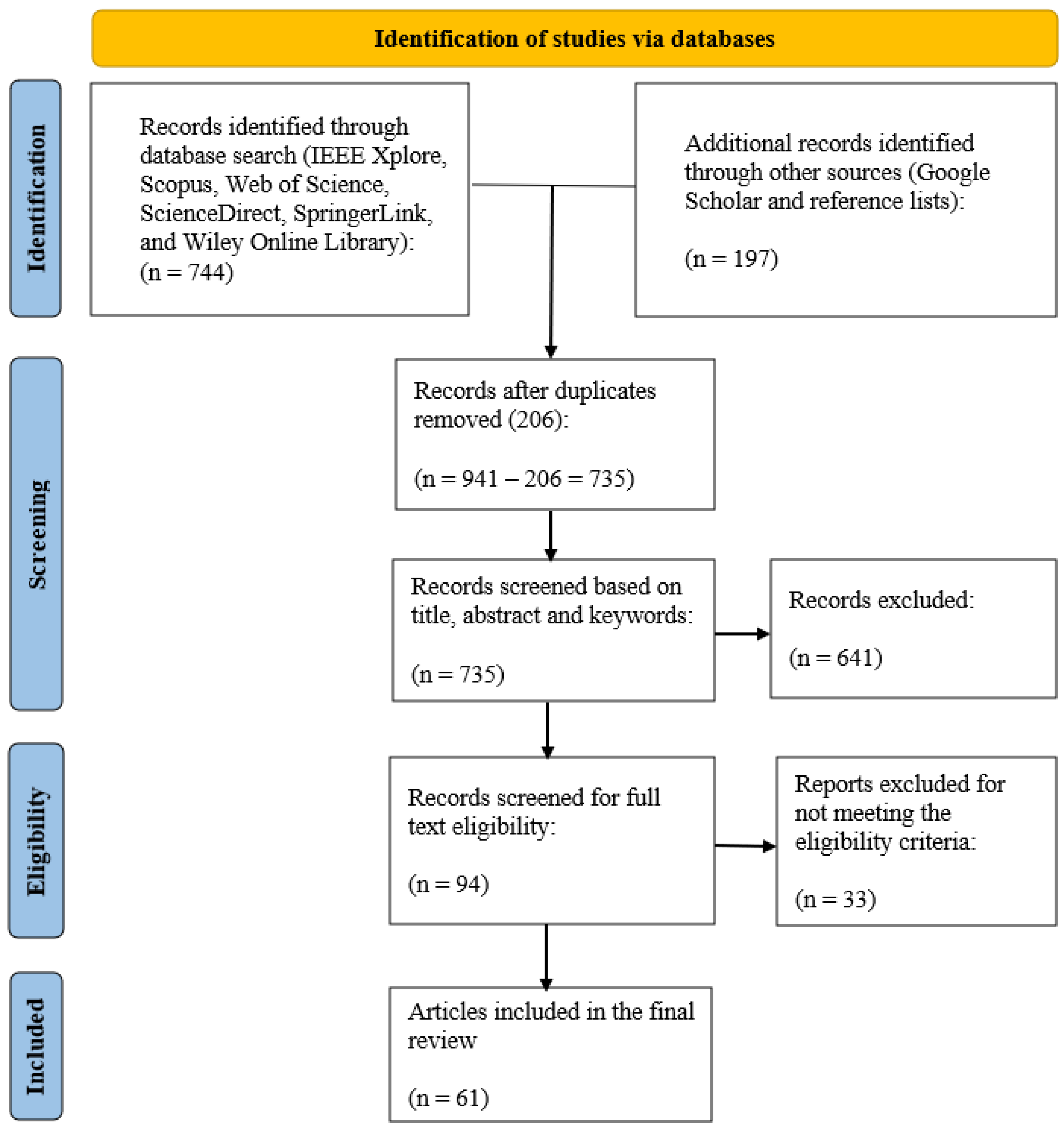
Figure 2.
Representative adaptive neural network pipeline for remote sensing tasks. Adaptive dimensions are: spatial adaptivity, spectral/multimodal adaptivity, temporal/dynamic adaptivity.
Figure 2.
Representative adaptive neural network pipeline for remote sensing tasks. Adaptive dimensions are: spatial adaptivity, spectral/multimodal adaptivity, temporal/dynamic adaptivity.
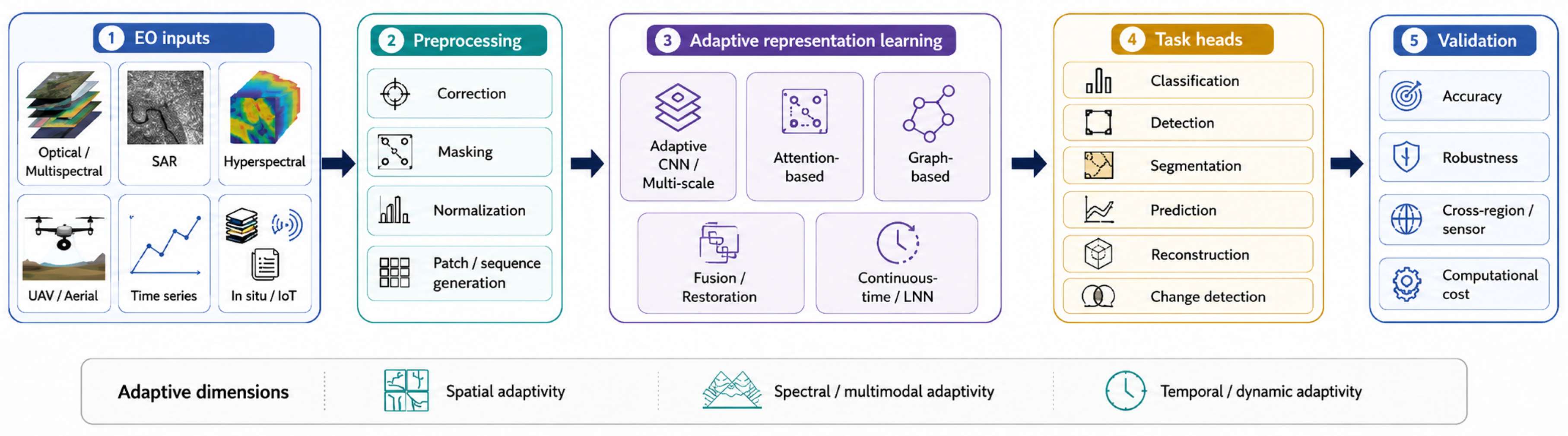

Table 1.
Distribution of included studies by primary remote sensing data type or source.
| Primary remote sensing data type or source | n | % |
|---|---|---|
| Optical, multispectral, and general remote sensing images | 26 | 42.6% |
| Earth observation and environmental time series | 10 | 16.4% |
| Hyperspectral imagery | 9 | 14.8% |
| SAR imagery | 6 | 9.8% |
| UAV and aerial imagery | 6 | 9.8% |
| Multimodal and fusion-based remote sensing data | 4 | 6.6% |
| Total | 61 | 100% |
Table 2.
Distribution of included studies by dominant application domain or remote sensing task.
| Application domain or remote sensing task | n | % |
|---|---|---|
| Classification and mapping | 15 | 24.6% |
| Object and target detection, tracking, and recognition | 13 | 21.3% |
| Environmental, hydrological, and meteorological prediction | 9 | 14.8% |
| Image restoration, reconstruction, fusion, and enhancement | 8 | 13.1% |
| Segmentation and extraction | 7 | 11.5% |
| Urban mobility, infrastructure, and cross-view analysis | 5 | 8.2% |
| Change detection | 4 | 6.6% |
| Total | 61 | 100% |
Table 3.
Taxonomy of adaptive neural network approaches in remote sensing and Earth observation.
| Adaptive approach | Adaptive role in remote sensing | Representative tasks |
|---|---|---|
| Adaptive CNN / multi-scale | Adapts receptive fields, feature aggregation, or sampling to spatial heterogeneity, object scale variation, texture complexity, and boundary uncertainty. | Segmentation; object detection; building extraction; hyperspectral classification |
| Attention-based | Weights spatial, spectral, temporal, or channel features to improve context selection, feature discrimination, clutter suppression, and long-range dependency modeling. | Classification; change detection; SAR tracking; shadow detection |
| Graph-based / relational | Models spatial, geographic, or multimodal relationships between pixels, objects, regions, sensors, or environmental variables. | Urban prediction; infrastructure analysis; landslide susceptibility; cross-view matching |
| Fusion / restoration | Combines complementary sources or reconstructs degraded observations affected by missing data, atmospheric effects, resolution differences, or sensor-specific degradation. | Pansharpening; dehazing; super-resolution; image fusion; time-series reconstruction |
| Continuous-time / LNN | Represents irregular sampling, temporal gaps, nonlinear dynamics, and non-stationary environmental processes through dynamic state evolution or adaptive time constants. | Flood prediction; crop classification; hyperspectral classification; change detection |
Table 4.
Summary of methodological evidence across adaptive neural network families.
| Model family | Evidence strength | Main interpretation |
|---|---|---|
| Adaptive CNN / multi-scale | Moderate | Frequently evaluated in image-centered remote sensing tasks, with relevant baselines in many studies; limitations include task-specific designs and limited cross-region validation. |
| Attention-based | Moderate | Useful for spatial, spectral, temporal, and channel weighting; evidence is strongest when ablations isolate the attention component. |
| Graph-based / relational | Limited–moderate | Relevant for spatial dependency, urban analysis, infrastructure monitoring, and multimodal relations, but difficult to compare across heterogeneous graph designs. |
| Fusion / restoration | Moderate | Supported in pansharpening, dehazing, super-resolution, reconstruction, and multimodal fusion; evidence depends strongly on degradation assumptions and data settings. |
| Continuous-time / LNN | Limited but promising | Aligned with irregular, noisy, and dynamic observations, but current evidence is recent and limited by inconsistent computational and reproducibility reporting. |
Disclaimer/Publisher’s Note: The statements, opinions and data contained in all publications are solely those of the individual author(s) and contributor(s) and not of MDPI and/or the editor(s). MDPI and/or the editor(s) disclaim responsibility for any injury to people or property resulting from any ideas, methods, instructions or products referred to in the content. |
© 2026 by the authors. Licensee MDPI, Basel, Switzerland. This article is an open access article distributed under the terms and conditions of the Creative Commons Attribution (CC BY) license (http://creativecommons.org/licenses/by/4.0/).
Copyright: This open access article is published under a Creative Commons CC BY 4.0 license, which permit the free download, distribution, and reuse, provided that the author and preprint are cited in any reuse.