

Submitted:
09 May 2026
Posted:
12 May 2026
You are already at the latest version
Abstract
This study examines the north-western access corridor to Žilina through the Kysuca valley (the Kysucká brána area) and the Budatín crossing during the revolutionary years 1848–1849. Using local archival excerpts, a regional chronicle manuscript and a cartographic reading of historical and present-day topography, we reconstruct the probable road alignment between Brodno, Budatín and the bridgehead towards Žilina and identify its recurrent military use by Imperial, Hungarian and Russian forces. The paper argues that the corridor’s strategic value stemmed from a combination of terrain constraints (narrow valley and floodplain), bridge dependence and the connectivity of the Jablunkov Pass trade route. We provide a chronology of troop movements in 1848–1849 and discuss source limitations, including internal inconsistencies in local narratives that require verification against primary military records. The article contributes a microhistorical case study to military geography of Upper Hungary and highlights the analytical potential of regional sources when integrated with critical source evaluation.
Keywords:
military geography
; Kysuca valley
; Budatín
; Slovak volunteer corps
; 1848–1849 revolutions
; historical road network
1. Introduction
The area of present-day Budatín (a borough of Žilina) and the neighbouring settlements in the lower Kysuca valley constituted, in the nineteenth century, a critical transport node between the north (Silesia, the Jablunkov Pass) and the Váh valley region. During the revolutionary years 1848–1849, this corridor repeatedly became the scene of troop movements and armed encounters. The aim of this study is to (a) reconstruct the most probable road alignment in the Budatín cadastral area at the turn of 1848/1849, (b) summarize and systematize a chronology of military movements linked to this corridor, and (c) assess which factors increased its strategic value while also increasing its vulnerability (especially bridge crossings) (Deák, 1979; Bona, 1999; Kováč, 1998).
2. Sources and Methods
Our primary regional point of departure is a manuscript compilation devoted to the history of Rudinka and its surroundings, which summarizes archival visits (state archives, parish registers, museum institutions) and contains transcriptions or paraphrases of selected sources. For the problem addressed here, the chapters on Budatín and on troop movements in 1848–1849 are crucial. Methodologically, we proceed by (1) excerpting the text and thematically sorting information, (2) cartographically interpreting the described points (cemetery, St Anne’s chapel, belfry, bridge crossing) as stable reference features, (3) critically evaluating the sources—identifying possible transcription errors and inaccuracies in dates and numbers, and (4) confronting key claims with available scholarly and encyclopaedic sources on the broader context (the Jablunkov Pass, the Russian intervention, Slovak volunteer expeditions) (Subiak, 2021; Rapant, 1937; Dohnány, 1988). The cartographic reconstruction was based on georeferencing of historical maps (e.g., 2nd Military Survey) in a GIS environment (QGIS). Identified stable landmarks (cemetery, chapel, bridgehead) were used as control points. The reconstructed route was then compared with present-day digital elevation models (DEM) to verify terrain constraints and route plausibility.
3. Corridor Context: the Jablunkov Pass, the Kysucká Brána, and Budatín
The Jablunkov Pass has long been one of the main crossings between Upper Hungary and Silesia. Scholarship notes its role in older trade routes (salt, amber) and, from the fifteenth century, also in the so-called Copper Route connecting Hungarian mining regions with Silesia. The northern entry into the Žilina Basin is spatially concentrated in a narrow section between the Rochovica and Brodnianka massifs (“Kysucká brána”), where traffic flows naturally converged. Budatín, at the confluence of the Váh and Kysuca rivers, constituted the bridgehead of Žilina and a point at which decisions about crossing the Váh and connecting to the Váh valley route toward Strečno and Turiec were effectively made. In such a configuration, bridge and ford infrastructure becomes decisive: damage to, or dismantling of, a bridge can paralyze movements and force detours (Beliana, 2024; Mazúr & Lukniš, 1978).
4. Reconstruction of the Road Alignment in the Budatín Cadastral Area (1848–1849)
The description in the regional manuscript is based on an analysis of a period map and on the identification of the oldest still-preserved landmarks of Budatín: the cemetery, St Anne’s chapel, the belfry, and the area of the bridge crossing over the Váh. These points allow us to approximate where the road ran from the Kysucká brána to Žilina and how, within the Budatín cadastral area, it connected to the bridge. The following part of the article therefore presents an edited and structured selection of key passages from the regional source (Subiak, 2021).
The “Forty-Eight” Years
The term Slovak volunteers immediately evokes a national connotation. The ordinary reader imagines Slovaks fighting for national interests. However, many people in the region mistakenly associate the Slovak volunteers with the Czechoslovak volunteer legions of the First World War, or with resistance fighters of the Second World War.
The true origin and significance of the Slovak volunteers—who fought during the revolutionary years 1848–1849 in the Kingdom of Hungary and even passed through Rudinka—played an important role in local as well as Slovak history.
The Historical Significance of Budatín
Originally, Budatín was part of the Budatín feudal estate together with nearby present-day suburban parts of Žilina—Brodno, Považský Chlmec, Vranie and Zádubnie—as well as villages in the lower Kysuca region. Budatín Castle, still a well-known landmark of Žilina today, has always been a key point of the estate. Its strategic importance lay in its position at the confluence of the Kysuca and Váh rivers. This naturally made the area significant as a transport and orientation artery between Slovakia and Silesia. From 1321, the castle fortification, near a ford, served to protect a toll and customs station located in the residential spaces of the tower. Merchants passing through the area therefore had to pay not only a toll for passage but also customs duties on transported goods.
Budatín is first mentioned in writing as an independent village in 1438 in connection with the construction of a wooden bridge over the Váh River that linked the Budatín estate and Žilina. Budatín forms Žilina’s entry gate from the north-eastern direction, from the Kysuce region. Routes coming from the Nitra region and the Váh valley met here and continued north through Kysuce to Silesia and Poland.
The construction of the bridge enabled better connections with Kysuce merchants, and especially with merchants from nearby Poland, the Czech lands and Germany.
The trade route connecting Silesia and the Váh valley began in the Silesian town of Cieszyn (Tešín), from which it ran along the Olza River valley to Polish Jablunkov, crossed the Jablunkov Pass, and continued to Krásno nad Kysucou and Kysucké Nové Mesto toward Žilina. Before entering Žilina, merchants using this route had to stop in Budatín to pay tolls at the royal tridsiatok (thirtieth) station. Their journey then continued along the Váh valley toward Strečno and Priekopa (today part of the town of Martin). In Turiec, the route ran via Sučany, Kraľovany, Ružomberok and Likava to Liptovský Mikuláš, via Hybe, and further to the Spiš region.
The main alignment of the Silesian Road followed the Kysuca River valley on its left bank. When tracing the road within the Budatín cadastral area, one can start near Brodno, after passing through the Kysucká brána between the Rochovica and Brodňanka hills. The siting relates to Mount Rochovica, whose eastern slope consists of rocks descending steeply to the Kysuca. The route therefore had to run on the left side of the Kysuca River, along the western slope of the Brodňanka hill.
Budatín itself, as well as the neighbouring village of Brodno, is pressed against the descending western slope of Dubeň, at a greater distance from the river. This retreat from the Kysuca River was caused by frequent floods, which is also mentioned in the mapping commentary. The road roughly followed today’s road from Budatín to Brodno, built to connect farmsteads and cut into a larger slope. Older residents of Budatín and Brodno also remember the original, lower-lying road, whose terrain modifications can still partly be observed today.
Identifying the Route of the Slovak Volunteers in 1848–1849
The analysis of the period map relied on the oldest buildings in Budatín that are still preserved: the cemetery, St Anne’s chapel, the belfry, and the bridge over the Váh River, located approximately where the old road bridge stood, the remains of which can still be readily recognized.
It is clear from the map that the original road ended at the Budatín cemetery, which demonstrably existed already in 1848 and 1849. The beginning of today’s Slovenských dobrovoľníkov Street (Street of the Slovak Volunteers) at this point exactly follows the original road. Near the cemetery, the road crossed a stream, continued below the cemetery past St Anne’s chapel, and then ran above the manor farm (majer), remnants of which can still be observed today, as confirmed by older inhabitants of Budatín. In the area of today’s junction by the shop, the old road followed the line of today’s Horná ulica (Upper Street) toward the aforementioned belfry. From the belfry and the municipal house—whose rough masonry structure still stands on this site—it continued along today’s ‘Hore’ street, down the ridge toward the bridge. Around the bridge, as a transport hub toward Silesia, Terchová and Orava, today’s Námestie hrdinov (Heroes’ Square) gradually emerged. In 1848–1849 the Slovak volunteers arrived in Budatín via this very route, as they advanced from Kysucké Nové Mesto. According to the 1820 map and the literature, the original settlement of Budatín lay in the area from St Anne’s chapel, above the manor farm toward the belfry, along today’s Horná ulica toward the small manor house (now modernized), and ended at the road to Teplička.
Movements of the Slovak Volunteers Along the Route in 1848–1849
The revolutionary years 1848/1849 did not bypass Žilina, nor Budatín. “In the Žilina area, honvéd troops and Hungarian national guards were concentrated, into which Slovaks and Hungarian volunteers were conscripted, in a number of about 2,600 men.” From 1798 Budatín became the property of the Csáky family. Ladislav Csáky, government commissioner and county head, became extremely active in the Hungarian revolution of 1848–1849. Through his stance he influenced events in favor of Magyarization in the north-west of today’s Slovakia and in Žilina itself. By the end of 1848, Žilina had become the seat of the Hungarian guard’s command, whose primary task was to defend the northern approach to the mining towns.
The Žilina area was affected only by the second phase of the uprising, which began at the end of November 1848 and continued through the winter months of the following year; it is also known as the winter expedition of the Slovak volunteers. Several hundred newly organized volunteers gathered near Tešín (today in Moravia; at the time in Silesia) under the leadership of Štúr and Hurban, as well as the experienced commander Bedřich Bloudek and his adjutant František Zach. Hurban’s proclamation “To the Slovak Nation” clarified the objective and served as a motivation for Slovaks to join the volunteer military unit. The Slovak expedition was organized as part of the Austrian imperial army commanded by Karl Friescheisen, in which the Slovak volunteers were to operate as an autonomous detachment.
On a historical map from the first military survey of the 18th century, the historic route leading from Budatín through the strategic Kysuce Gate area is highlighted in red. This important road crossed a ford at Malá Rudina and then continued northward through the Kysuce region to Čadca.
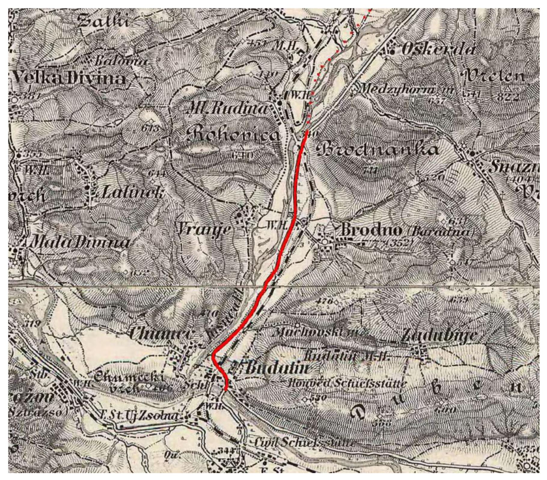
An 18th-century cartographic base map has been deliberately chosen, as it more accurately captures the original route of the road prior to the major transportation-related changes of later periods. Maps from the 19th century, although closer in time to the changes under study, already include the built railway infrastructure, which significantly influenced and, in some places, altered the original road route, particularly in the Kysuce Gate area. This transformative intervention in the landscape and transportation network can also be clearly observed in Figure 2.
First Troop Movements
Reports of some movement of enemy troops in Silesia began to circulate around Žilina in the autumn of 1848. On 21 October 1848, General Šimunič of the imperial army moved along the Silesian Road through the Jablunkov Pass to Čadca and as far as Kysucké Nové Mesto, from where he dispatched an advance detachment as far as Budatín. Soldiers could reach Budatín only via the Kysucká brána through the village of Rudinka. Based on knowledge of the terrain and the scholarly literature, we assume the troops had to cross the stream near the Budatín cemetery, pass St Anne’s chapel, go above the manor farm to the belfry, from where they descended along the slope to the area of today’s Heroes’ Square, crossed the bridge into Žilina, and then moved on to Trenčín. After the imperial army departed, representatives of the Hungarian side organized in guards arrived in Žilina; for example, there was also a guard from Mojš, Lúčky, Terchová, Strečno, Belá, Varín, Teplička, Višňové and Rosina. All able-bodied men were required to enlist in the Žilina guard. The guards were led by counts, noblemen and burghers. All marched toward Trenčín, pursuing Šimunič’s army, which dispersed them in the battle near Kostelná.
Second Troop Movement
At the beginning of November 1848, the Hungarian guards flooded Žilina. Via Budatín, along the road corresponding to today’s Slovenských dobrovoľníkov Street, they marched to Čadca to await the enemy imperial troops. As nothing happened, the guards gradually dissolved and returned home again via Budatín.
Third Troop Movement
The winter expedition of 1848 was divided into two streams. The first stream again set out from Tešín under the military command of Bedřich Bloudek, and of course with the participation of Ľudovít Štúr and Jozef Miloslav Hurban. “On 6 December 1848 the imperial troops moved from Silesia to Čadca, where they stayed until 11 December. The force had 600 infantrymen, of whom only 50 were cuirassiers, and one rocket launcher.”
Even before 11 December, leaders of the Hungarian guards led their contingents out of Žilina and deployed honvéd troops and Hungarian national guards—into which Slovaks and Hungarian volunteers were also conscripted, about 2,600 men—on the Budatín side. Another part crossed Budatín along what is today Slovenských dobrovoľníkov Street, past the cemetery to Brodno, where they set up sentries and dug a deep trench and abatis.
On 11 December, the imperial troops and volunteers set out. On Friescheisen’s orders, the force split. Friescheisen’s group proceeded “through the Jablunkov Valley to Čadca. From the hills they could already see the Hungarians, but they were retreating, so no shots were fired; without a shot they reached Čadca and Kysucké Nové Mesto.” Near Brodno they came into contact with Hungarian forward guards, who “bravely” retreated without firing. The Slovak expedition encountered the first organized resistance only around one o’clock between Brodno and Budatín. There were abatis on both sides, and a strong Hungarian guard waited in a deep trench. The main strength of the Hungarian force lay in the strategic placement of artillery. In trenches on a nearby hill above Budatín, the Hungarian guard had two guns, and a further four near the bridge over the Váh, to protect the entry into Žilina.
Schewitz’s company and the Hurbanists (three companies of Slovak volunteers) under Bloudek’s command were to carry out a flanking maneuver along the left-hand hills forward via Mount Oškerda and attack the guardsmen from the side. They marched through a ravine on the left toward the western hill of Dubeň, along a descending ridge toward Budatín. Their aim was to outflank the enemy’s right wing, threaten it with fire from the rear, and neutralize the Hungarian guns. Here, three companies of Slovak volunteers under Bedřich Bloudek outflanked the opponent’s right wing and, with a surprise attack, helped push the Hungarian guards toward the Csáky manor house, where fighting continued. Even in the new position the Hungarian guard could not hold; it retreated to the bridge but managed to dismantle it, preventing further advance of the imperial troops. The guards concentrated in Žilina were poorly armed and dispersed after the bridge was dismantled. The Hungarian troops and guardsmen deployed their guns on the Žilina sihot (the Váh floodplain) and shelled the imperial troops and volunteers, who were deployed in the gardens of Budatín Castle, to its left and inside it. General Friescheisen ordered counter-battery fire against the Hungarian guards. Hurban rode up to a hilltop and observed the battle from there. The shelling continued until evening. The paradox of the exchange was the shelling of Budatín Castle: the Hungarian troops and guardsmen were in effect destroying the residence of Count Csáky, their supporter.
The Hungarian troops withdrew as far as Predmier, where they waited for the imperial advance. General Friescheisen also decided the next day to retreat back to Čadca. Although the imperial troops and volunteers won the first Battle of Budatín, they subsequently withdrew back to Moravia due to supply problems and the destroyed bridge over the Váh.
The Battle of Budatín was an undisputed victory of the Slovak volunteer expedition. Bloudek’s revolutionary tactics proved effective, as the troops together with the volunteers managed to defeat an enemy with numerical superiority. The entire course of the fighting on 11 December 1848 entered history as the first phase of the winter expedition, under which name it is discussed in detail in the scholarly literature. There is little doubt that the first Battle of Budatín on 11 December 1848 unfolded precisely within the Budatín cadastral area.
Note on the map annex: The regional source refers to “the first phase of the winter expedition on the present-day map.” This working article does not include a graphic appendix; for publication we recommend adding a map (a georeferenced reconstruction of the route and battlefield) as Figure 1.
Fourth Troop Movement
Of course, it was not only the Hurbanists and the imperial army that moved along the route under study. Hungarian forces also used it. The road formed an important link with Silesia, from where a constant threat from the imperial army was perceived at the time. New units of the regular Hungarian army arrived in Žilina already on 14 and 15 December 1848, passed roughly along today’s Slovenských dobrovoľníkov Street toward Čadca, where they were to guard the border against a possible renewed incursion. The border watch lasted only a few days; the guard leaders disliked the accommodation in Čadca, and therefore returned to Žilina on 20 December.
Fifth Troop Movement
Another movement along the examined route took place during the second phase of the winter expedition. At the turn of 1848 and 1849, imperial troops again began to assemble in Tešín, this time under General Christian Götz. His corps was reinforced with artillery and with two battalions of regular troops. The Slovak corps had around 200 members; this number increased rapidly during the expedition into Slovakia. Bedřich Bloudek had proven himself as commander of the Slovak volunteers in the previous expedition, so General Götz entrusted him again with an important task. With the Hurbanists, Bloudek was to execute a strategically important flanking maneuver and, via Radoľa, Lopušná and Brodno, reach the enemy’s rear unnoticed.
Götz’s corps moved on 31 December 1848 from Mosty near Jablunkov toward Čadca, where it spent the night. The Slovaks with the division went to Turzovka due to demonstrations, from where on New Year’s Day they marched to Nesluša and around noon reached Kysucké Nové Mesto, where they joined the main column. Hurban recalls the events of New Year 1849 in a letter of 3 January 1849: “…in the morning we marched out ahead of General Götz and Colonel Frischeinsen from Nové Mesto nad Kysucou; half an hour before us our landsturm with Bloudek and two companies set out via Vadičov so that—by the time we reach Budatín—they would appear within reach on the Hungarians’ flank and behind their backs. Around ten o’clock we stopped at a hill above the Kysuca, near a narrow defile, behind which the Hungarian outposts were…” The Hurbanists thus left Kysucké Nové Mesto in the morning. The core of Götz’s detachment departed an hour later and, after roughly a two-hour march to Brodno through the Kysucká brána, reached the mouth of the Brodno defile, where they awaited the outcome of the planned flanking maneuver.
The second Battle of Budatín took place roughly in the same area as the first. The originally planned advance of the imperial troops, however, failed because Götz’s corps unexpectedly encountered honvéd forces at the Brodno defile. An artillery duel developed and Bloudek, who was completing the planned flanking maneuver, heard the cannonade, changed his route, and appeared on a hill above Budatín. From there he attacked the retreating honvéds, who were forced to withdraw across the bridge into Žilina. This time the Hungarians did not manage to dismantle the bridge. The damage was minor and could be repaired quickly. The Hurbanists entered Žilina singing “Hej, Slovane” and “immediately on the broad square they planted their national flag at the statue of Mary.” The expedition did not continue further; the command awaited the proclaimed counter-action of the honvéds to defend Žilina. The Hungarian guards, however, fled toward Strečno. On 4 January 1849, Ľudovít Štúr, Hurban and Friescheisen gave speeches on the main square in Žilina. Hurban describes the reactions of Žilina’s inhabitants as follows: “Oh my God, my God, what kind of people are these! What a difference between our people in Nitra and these Upper Trenčín folk!... Well, but what can one do? As they were taught, so they act. Error, superstition, stupidity, incomprehension—that is the fruit of teachings spread for centuries by our lordship and Magyarone clergy... Žilina itself is struck by a terrible blindness.” Despite the agitation, no one from Žilina, nor even from Rajec, volunteered for the army. The Slovak corps then operated for some time in Turiec and made expeditions to Orava and to Liptov.
Imperial soldiers remained in Budatín until 10 January 1849, when before departing they set fire from the inside to Budatín Castle, property of the Csáky family, probably as punishment for supporting the Hungarian revolution. The flames reportedly spread so widely that they could not be extinguished. Even the fire engines from Žilina did not help, as they were all frozen, and the castle was left a ruin.
Sixth Troop Movement—May 1849
From the arrival of the imperial troops at the beginning of 1849 and the dispersal of the Hungarian honvéds, Budatín and Žilina as a whole enjoyed relative calm from the Hungarian revolution. Apart from the events already mentioned, no fighting affected Žilina from January 1849 until 1 May 1849.
At the beginning of May 1849, however, Hungarian forces reappeared. General Artúr Görgey was moving with an army of about 600 hussars toward Varín. On 1 May 1849 fighting occurred near Varín. Owing to the inequality of forces, the imperial troops had to retreat to Nededza. Continuous pressure from the Hungarian guards then forced them to retreat as far as Teplička. On the hills between Teplička and Budatín, the imperial troops joined the remaining Deutschmeister units from Budatín that General Götz had left there. In this situation they spent the night and deliberated. Major Trenck—described as the worst leader—convinced everyone that the best retreat plan was via Budatín to Čadca, i.e., along the route already used during the winter expedition. The Hungarians began pursuit only on 2 May, toward Čadca. When the Hungarian force learned of an imperial march from Liptov, they turned back halfway and fled back.
On 9 May 1849 an imperial force under Benedek appeared from Silesia through the Kysucká brána at Budatín. Another part of the imperial army under Vogl approached Varín from Orava. Both forces remained in their positions until 12 May 1849 because there were no bridges: the Váh had carried away the bridge at Budatín. The soldiers therefore had to build a raft bridge near the salt warehouse (today in Žilina near the pulp mill area). During the night of 12 May 1849 General Benedek ferried his troops, including guns, by boats from Budatín to Žilina, where they rested on 13 May. By then the bridge at the salt warehouse had also been completed, allowing General Vogl’s troops to cross from Varín to Žilina. On 14 May 1849 the imperial troops left Žilina, but they left a garrison of 300–400 men in Budatín under Major Trenck.
Soon afterwards, on 26 May 1849, an imperial force under General Bárka marched from Silesia into Hungary. The force again chose the route through Budatín. It passed through Čadca and then via the Kysucký Pass to Budatín. In Budatín, however, it could not cross the Váh because the bridge had still not been repaired. The retreating General Vogl had taken the bridge at the salt warehouse, and General Benedek also removed his boats. The imperial force remained trapped in Budatín until the soldiers built a bridge over the Váh. According to the sources, construction began “by three willows.” After 150 years this is difficult to pinpoint, but it must have been somewhere on the Budatín bank of the Váh. The bridge was completed in 22 days. During construction the force was struck by cholera; even the commander, Bárka, fell ill but recovered. Cholera spread to the surroundings of Teplička nad Váhom and even Žilina, where roughly 2,000 soldiers became ill. Colonel Karl Keller also fell victim to the disease in Budatín and is buried there. On the morning of 16 June 1849 General Bárka crossed the newly built bridge and marched to Trenčín, again leaving about 1,000 soldiers in Budatín.
Seventh Troop Movement
The last major movement in 1848–1849 was the march of the Tsarist Russian army, which played a decisive role in the outcome of the revolutions of 1848/1849. On 17 June 1849, a Tsarist Russian army of more than 110,000 men under General and Warsaw Prince Paskevich entered Hungary from several directions. In Slovakia, Russian forces entered in the east via the Dukla Pass and in the north-west via the Kysuce narrows. Once again, the Budatín area proved strategically significant. Part of the Tsarist army advanced precisely along the Silesian Road through Kysuce toward Žilina, where it inevitably had to pass through the known Budatín route. The Russian troops were invited to aid Hungary by the new emperor Franz Joseph I. The military assistance of Tsar Nicholas I was meant to definitively suppress the Hungarian revolution—and it did.
Movements of the Tsarist Army through Budatín
On 24 June 1849, a column of about 400 wagons loaded with ammunition arrived beneath Dubeň via the Terchová road, heading toward Orava. The bridge over the Váh was still damaged. The column must have arrived through the Kysucká brána.
On the morning of 27 June 1849, an advance patrol consisting of seven Don Cossacks arrived. In the evening, about 137 Don Cossacks entered Žilina on horseback. They had to reach the town along the course of the Kysuca River via Budatín. They only refreshed themselves and watered their horses, then continued toward Rajec.
On 4 July 1849, about 800 Tsarist soldiers moved toward the Žilina (Budatín) bridge from Varín. Near Strečno, however, Don Cossacks forded the Váh and entered Žilina; after a short stop they continued along the Strečno road into Turiec.
On 10 July 1849, Russian cavalry under Chovan and Fridrix appeared in the area. Four thousand soldiers arrived from Čadca via the Kysuce narrows, so once again the force necessarily had to pass through Budatín, from where it proceeded across the area of today’s Heroes’ Square toward the bridge. The force camped overnight on the Žilina sihot (the Váh floodplain) by the Všivák stream among willows. They left in the morning.
On the afternoon of 11 July 1849, another 4,000 Russian soldiers commanded by Kecevič and Loth passed through the area under study. They stayed overnight on the Žilina floodplain.
On the morning of 12 July 1849, all Russian troops departed along the Strečno road into Turiec. This ended the passage of Tsarist forces through Budatín and Žilina.
Eighth (Final) Troop Movement
Throughout the summer until October 1849, Žilina and Budatín were quiet after the revolutionary events. No reinforcements passed through the area and no troops retreated, whether imperial or Hungarian. The final military movement of the revolutionary years 1848 and 1849 was the victorious march of the Tsarist army back home.
After the victorious battle at Világos in August 1849, the inhabitants of Žilina expected the arrival of Tsarist Russian forces on their way home. In October 1849, the anticipated massive transit began through Žilina and Budatín.
On 5 October 1849, a column of 175 wagons from Komárno to Orava passed through Žilina and Budatín toward Čadca, already over a fortified bridge. The column carried military ammunition and booty back to Russia. In Budatín, it camped overnight on the Csáky estate. The next day it departed. For accommodating the Russian troops, quarters were selected not only in houses but also in barns, and these were used until 13 October.
On the evening of 13 October 1849, Don Cossacks under Grabbe arrived singing; they did not stop in Žilina but went straight to the established camp in Budatín. On the same day, uhlans (Polish cavalry) under Loth arrived.
On 14 October 1849, Don Cossacks and uhlans under Choven came to Žilina; they only passed through the town and were also quartered in Budatín.
On 15 October 1849, the remaining cavalrymen and the logistical support of the cavalry and wagon train passed through. In total, around 6,000 soldiers were present in Žilina, and thus directly in Budatín, during this period.
On 16 October 1849, 8,000 infantrymen with part of the artillery under General Grabbe arrived in Žilina and Budatín.
On the morning of 17 October 1849, General Grabbe and his entourage departed for Russia. They marched toward Čadca and continued home along the Silesian Road. The rest of the troops remained in the camp at Budatín.
On 18 October 1849, the commander of the artillery, Nikolayev, also departed with his troops in the same direction toward Čadca.
On 19–20 October 1849, all Russian troops left the Žilina and Budatín area.
Between 5 and 20 October 1849, 22,900 Russian soldiers—infantry and cavalry—passed through Žilina and Budatín. They carried war booty with them: horses, carriages, wagons, cows, oxen, donkeys, dogs, and even gardening tools. They even took abandoned boys from Hungary, from whom they planned to raise capable soldiers.
These findings indicate that the road leading through Budatín via the Kysucký Pass toward Brodno, through the Kysucká brána—and thus also through Rudinka—toward Čadca played an important historical role as a link between Žilina and the Silesian border. The troop movements during the revolutionary years in this very area also demonstrate this. In 1848 and 1849, the strategic location of Žilina—and especially Budatín—was confirmed: it was the connector between the upper Váh valley and the lower Kysuca valley and, consequently, with Silesia, as well as with Turiec and Rajec. Žilina, and Budatín as its bridgehead, was—according to Hungarian representatives of Trenčín County as well—considered the best centre of defence; for that reason it played a significant role both for the Hungarian revolutionary guards and for the imperial army.
5. Additional Source Context: Boundary Survey of the Budatín Estate (1438) and Toponyms around Rochovica
Although the events of 1848–1849 are separated from medieval perambulation documents by more than four centuries, the boundary survey of 1438 is useful for capturing the long-term stability of certain toponyms and spatial relations at the interface of the Žilina Basin and the lower Kysuce region. The following excerpt records a boundary segment with an explicit mention of Mount Rochovica, the road between Vranie and Rudina, and the entry into the Kysuca River.
Then it continues in the same direction and comes to a newly heaped boundary marker that separates the estate of Vranie from the aforementioned Lalinek. Then it goes to Bird Hill (Vtáčí vrch) and descends to a small valley and turns west, passes alongside the territory of Lalinek, and comes to the meadows of the town of Žilina. Then it turns north to a small hill that borders the said Žilina meadows. From there it goes to the meadow of the Rudina estate, then turns east at the edge of Mount Rochovica. Then it turns south and, crossing a road, turns east, descending along the road between the lands of Vranie and Rudina, where a boundary marker was erected; from there it comes to the spring called Drieňová studnica designated as a boundary sign. Then, descending, it comes to another spring called Na Vranovine and enters a deep river or stream and goes down along the stream itself, turns slightly south and returns east, and comes to the pond called Močidlá, where a boundary marker was made between Brodno and Rudina; it turns north across the same pond and enters the Kysuca River, where a boundary marker was set, and ascending along the Kysuca River itself it comes to an estate called Oškerda and returns west along the stream Rudinský potok.
6. Discussion: The Corridor’s Strategic Value and the Limits of the Regional Source
The regional source convincingly shows that the main “Silesian” route in the Budatín section was determined by valley morphology and the need to cross the Váh. From a military-geographical perspective, it is crucial that any military formation approaching from the north had to pass through the narrow throat of the Kysucká brána and then deal with the bridge node at Budatín. The bridge therefore emerges as a critical point: its dismantling or being washed away (as repeatedly stated in the source) fundamentally changes tactical options. At the same time, the limitations of the manuscript material must be emphasized: it is a compilation working with secondary reports, memoir quotations, and regional tradition. The text also contains indications of transcription errors (e.g., the date 5 October in the description of the Russian departure is, in context, clearly linked to 1849 rather than 1848; similarly, the notation “approx. 6,000” soldiers is probably meant as 6,000 rather than “6,000 thousand”). Such passages should be verified in primary military and administrative holdings (daily orders, logistics reports, county protocols, contemporary press). For publication in an indexed journal, it will be decisive to add a critical apparatus: precise references to archival holdings, identification of the map used (year, scale, publisher), and an explicit methodology of cartographic reconstruction (e.g., georeferencing, comparison with a digital elevation model) (Beliana, 2024; Mazúr & Lukniš, 1978; Bona, 1999).
7. Conclusions
This case study shows that the Kysucká brána–Budatín corridor functioned in 1848–1849 as a repeatedly used military line of communication linking northern approaches (the Jablunkov Pass and Kysuce) with the Žilina area and the Váh valley. Its strategic importance derived from the concentration of traffic in a narrow terrain bottleneck and from the presence (or absence) of bridge crossings over the Váh. The regional source provides a detailed local chronology, but its full scholarly usability presupposes verification of selected claims in primary holdings and an explicit treatment of the cartographic method. As a microhistorical probe, however, it shows that even regional compilations can—when read critically—substantially enrich military history and the historical geography of north-western Slovakia (Bona, 1999; Rapant, 1937; Roberts, 1991).
Affiliation
This article is a partial output of a grant-funded project. This article is a partial output of the UNIZA Grant System project: 21148 Roots and Transformations: A Historical Study of Life in the Village of Rudinka.
References
- Beliana. Jablunkovský priesmyk. In Encyclopaedia Beliana; Centrum spoločných činností SAV, 2024. [Google Scholar]
- Beliana. Kysuca. Encyclopaedia Beliana (Centrum spoločných činností SAV). 2024. Published.
- Bona, G. (Ed.) The Hungarian Revolution and War of Independence, 1848–1849: A Military History; Boulder, CO; Social Science Monographs / East European Monographs, 1999. [Google Scholar]
- Britannica. Hungarian Revolution of 1848–1849; Encyclopaedia Britannica, n.d. [Google Scholar]
- Dangl, V. Bitky a bojiská v našich dejinách; Bratislava; Perfekt, 2017. [Google Scholar]
- Deák, I. The Lawful Revolution: Louis Kossuth and the Hungarians, 1848–1849; New York, Columbia University Press., 1979. [Google Scholar]
- Dohnány, M. Historia povstaňja slovenskjeho z roku 1848; Bratislava; Tatran, 1988. [Google Scholar]
- Kováč, D. Dejiny Slovenska; Praha; Nakladatelství Lidové noviny, 1998. [Google Scholar]
- Mazúr, E.; Lukniš, M. Regionálne geomorfologické členenie SSR. Geografický časopis 1978, 30(2), 101–125. [Google Scholar]
- Pisoň, Š.; Velba, M. Naše hrady a kaštiele; Bratislava; Mladé letá, 1973. [Google Scholar]
- Rapant, D. Slovenské povstanie roku 1848–49: Dejiny a dokumenty; Martin; Matica slovenská, 1937; Vol. 1. [Google Scholar]
- Roberts, I. W. Nicholas I and the Russian Intervention in Hungary; Houndmills; Macmillan; in association with SSEES, University of London, 1991. [Google Scholar]
- Subiak, J. Rudinka. Regional manuscript compilation (unpublished manuscript—private archive). 2021.
Figure 1.
A map excerpt showing the route from Budatín through Kysucká Brána toward Čadca. Source: Arcanum Maps, First Military Survey of the Habsburg Empire, 18th century.
Figure 1.
A map excerpt showing the route from Budatín through Kysucká Brána toward Čadca. Source: Arcanum Maps, First Military Survey of the Habsburg Empire, 18th century.
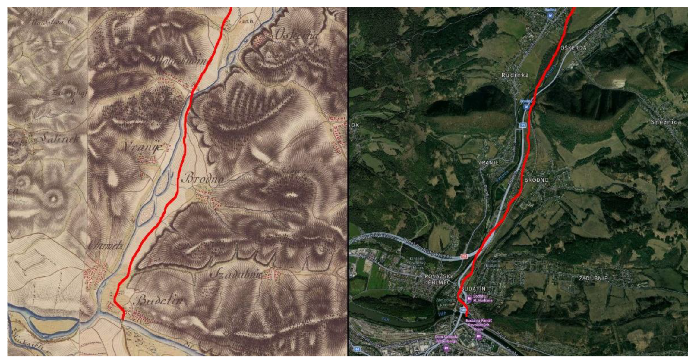
Figure 2.
The map from the third military survey of the second half of the 19th century clearly shows the completed railway line, which had a significant impact on the original routing of historic roads in the area under study. Source: Arcanum Maps, Third Military Survey of the Austro-Hungarian Empire, 19th century.
Figure 2.
The map from the third military survey of the second half of the 19th century clearly shows the completed railway line, which had a significant impact on the original routing of historic roads in the area under study. Source: Arcanum Maps, Third Military Survey of the Austro-Hungarian Empire, 19th century.
Disclaimer/Publisher’s Note: The statements, opinions and data contained in all publications are solely those of the individual author(s) and contributor(s) and not of MDPI and/or the editor(s). MDPI and/or the editor(s) disclaim responsibility for any injury to people or property resulting from any ideas, methods, instructions or products referred to in the content. |
© 2026 by the authors. Licensee MDPI, Basel, Switzerland. This article is an open access article distributed under the terms and conditions of the Creative Commons Attribution (CC BY) license (http://creativecommons.org/licenses/by/4.0/).
Copyright: This open access article is published under a Creative Commons CC BY 4.0 license, which permit the free download, distribution, and reuse, provided that the author and preprint are cited in any reuse.