
Submitted:
07 June 2025
Posted:
09 June 2025
You are already at the latest version
Abstract
Soil infiltration at the watershed scale is a crucial aspect of hydrological processes, significantly impacting runoff, groundwater recharge, and ecosystem health. The research of soil infiltration at the watershed scale using the Soil and Water Assessment Tool (SWAT) model has garnered continuous attention from scholars, with a growing trend in publications overall. This study selected 141 articles from the Web of Science (WOS) Core Collection database and conducted bibliometric analysis using the CiteSpace visualization software to analyze the research hotspots and trends in soil infiltration at the watershed scale using the SWAT model. The results indicated that the research field is interdisciplinary. Journal of Hydrology and Hydrological Processes were two of the most influential journals. Researchers and institutions from the United States, China, and Ethiopia were the core contributors to this area. “Land use” and “climate change” were currently the hotspots of interest in this field. There are three development trends: (1) The scale of research is continuously expanding. (2)The research subjects are diversified, ranging from initially focusing on agricultural watersheds to surrounding areas such as hillsides, grasslands, and forests. (3) The research content becomes more systematic, emphasizing regional coordination and ecological sustainability. Overall, the research on Soil Infiltration at the Watershed Scale Using the SWAT Model presents a promising and thriving field. This study provides researchers with a framework that objectively presents the research hotspots and trends in this area, offering valuable insights for future scholars conducting research on soil infiltration at the watershed scale using the SWAT model.
Keywords:
soil Infiltration
; watershed scale
; SWAT model
; bibliometric analysis
; CiteSpace
; research hotspots and trends
1. Introduction
Soil infiltration is a crucial process in the hydrological cycle of terrestrial ecosystems, influencing vegetation water balance, surface soil erosion, runoff, and groundwater recharge(Ilstedt et al., 2007; Zhao et al., 2013; Sun et al., 2018). As urbanization progresses, soil infiltration rates decrease, increasing surface runoff and disrupting watershed systems, further disrupting the balance of ecosystems(Lammers et al., 2022; Walsh et al., 2005). Excessive soil infiltration rates and saturated overland flow are predominant processes in many watersheds(Vieux, 2016). Identifying the impact of runoff at the watershed scale is crucial for effective water resource management(Vafakhah et al., 2019). Surface soil in watersheds can influence the redistribution of water and materials(Riza et al., 2021) and plays a pivotal role in the hydrological response leading to runoff generation(Sarangi et al., 2006). Therefore, understanding the dynamics of soil infiltration is crucial for effective watershed management and sustainable water resource utilization, Especially in the face of changing climatic conditions and human-induced land use activities.
Existing watershed-scale soil infiltration models primarily include the Soil and Water Assessment Tool (SWAT) (Desta and Lemma, 2017; Bosch et al., 2010), the Green-Ampt Theory Model(Langhans et al., 2014; Farajalla and Vieux, 1995), the Horton Infiltration Model(Lammers et al., 2022; Vafakhah et al., 2019), the Stormwater Management Model (SWMM) (Lammers et al., 2022), the Gridded Surface Subsurface Hydrological Analysis (GSSHA) model(Downer and Ogden, 2004), remote sensing and GIS(Starks et al., 2003), Revised Universal Soil Loss Equation (RUSLE)(Das et al., 2021), etc. Among these models, SWAT is one of the most widely used internationally(Aloui et al., 2023; Tan et al., 2020). SWAT is a continuous-time model that covers small watershed-to-basin scales(Arnold et al., 1998). It predicts runoff based on soil and land use, incorporating a type of infiltration-excess runoff(Hoang et al., 2017). The first version of SWAT was developed in 1993(Engel et al., 1993). Subsequently, its functions and modules have been continuously expanded and improved. Many flexible evolution versions of “SWAT+” have been created(Bieger et al., 2017). SWAT+ has advantages over the traditional SWAT model in database management, connectivity, aquifer boundaries, and other aspects(Yen et al., 2019). The SWAT model integrates various hydrological and land use parameters to simulate runoff, sediment yield, nutrient transport, and infiltration zoning(Rocha et al., 2012; Qi et al., 2020), enabling researchers to assess the effects of different scenarios on soil infiltration and watershed hydrology. It has been proven to be a powerful interdisciplinary modeling tool, capable of simulating various watershed problems(P. W. Gassman et al., 2007; Gassman et al., 2014). Up to date, there have been some reviews on SWAT modeling on extreme hydroclimatic events(Tan et al., 2020) and ecosystem services(Francesconi et al., 2016). However, a lack of comprehensive integrated analysis of SWAT-related research on watershed-scale soil infiltration exists. Given the importance of soil infiltration and the widespread use of the SWAT model in hydrological research, it is necessary to conduct a comprehensive literature analysis of this field to identify research hotspots, trends, and emerging topics.
Bibliometric analysis is a scientific research technique based on historical publication information to identify relevant field hotspots and research trends(Wen et al., 2023). Currently, several academic visualization bibliometric analysis tools are available, including CiteSpace(Chen, 2017), VOSviewer(Chen and Song, 2019), and Gephi(Chen et al., 2010). CiteSpace is a commonly used information visualization analysis software, due to its user-friendly interface and clear visualization capabilities(Jiang et al., 2017). The software can statistically analyze the overall situation in a research field over a specified period, including topic focus, research institutions, major scholars, author collaboration, and document coupling within the designated time range. It constructs knowledge maps of a particular field, showcasing and analyzing the evolution trends, hot topics, and knowledge associations of the discipline forefront through node size and network connectivity(Zhao and Zhang, 2023; Leal Filho et al., 2022). This advantage assists scholars in quickly understanding the relevant status of the field and predicting future research directions. To comprehensively learn about past research on “soil infiltration at the watershed scale using the SWAT model”, this study systematically analyzed relevant literature in this field over the past 25 years using the CiteSpace software. To the best of our knowledge, there have been few studies that utilize CiteSpace to analyze literature related to soil infiltration at the watershed scale.
This study aimed to collect, analyze, and organize relevant literature in the research field using the SWAT method to analyze soil infiltration at the watershed scale, with the intention of elucidating (1) the development trends in research on soil infiltration at the watershed scale using the SWAT method; (2) the influential authors, countries, institutions, and publications in the academic community; and (3) the hotspots and future trends in this research field. This study aimed to provide a scientific reference for future research on watershed-scale soil infiltration using the SWAT model.
2. Methodology
2.1. Data Acquisition
In the current academic literature repository, the Web of Science(WOS) aggregates over 12,000 globally recognized high-impact scientific journals, making it a valuable dataset for global academic intelligence(Wang et al., 2023). In this study, the data was retrieved on April 23, 2024, within the WOS Core Collection database (with Science Citation Index Expanded only) from 1999 to 2023 and was further refined to include articles published in English only(the earliest literature retrieved in this field dates back to 1999 and due to the limited number of publications in 2024, they were excluded to ensure the stability of the results). To ensure an exhaustive and focused search of relevant literature, we employed a strategically formulated Boolean search algorithm: TS = ((“watershed” OR “river” OR “stream”) AND “soil infiltration” AND “SWAT”).
A total of 145 articles were retrieved. We checked and sorted them by topic relevance, removed entries with minimal relevance, and ultimately screened 141 articles.
2.2. Bibliometric Analysis and Visualization
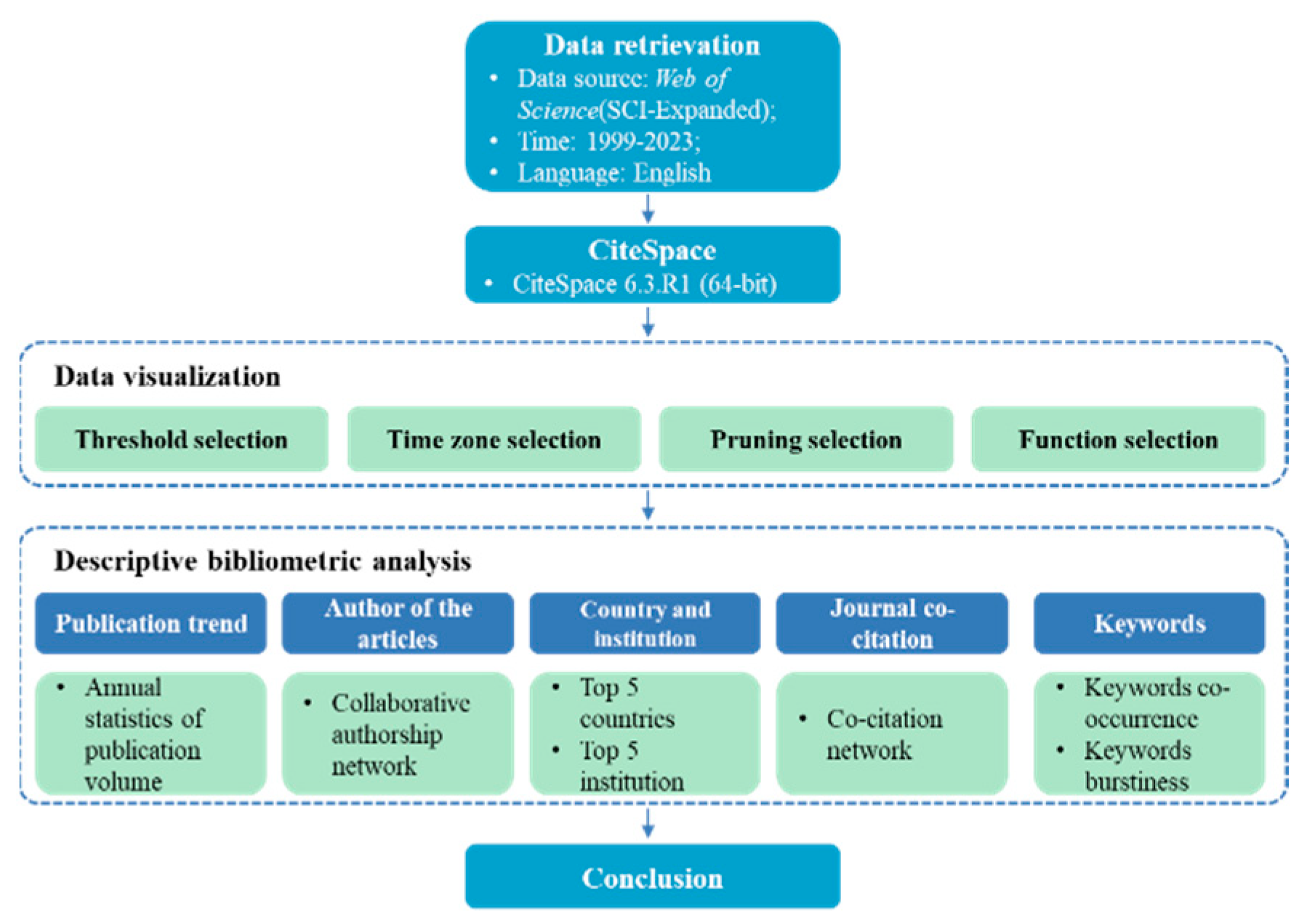
The primary research tool is the CiteSpace 6.3.R1 information visualization analysis software. We operated removing duplicates in CiteSpace for the 141 screened documents, all 141 papers were retained for in-depth analysis. The dataset was profiled in this software after a series of rigorous adjustments, including setting thresholds, adjusting time zones(1999-2023), and selecting attributes. A knowledge map of research areas in “soil infiltration at the watershed scale using the SWAT model” was constructed and analyzed with authors, countries, institutions, journals co-citations, and keywords as nodes. In the figures, nodes represent analytical entities (such as authors, countries, institutions, etc.), depicted as concentric circles, with the color denoting the time of appearance. The size of each node indicates the volume or frequency of publications. Lines connecting nodes represent collaboration, co-occurrence, or co-citation between them, line color indicates the years of co-citation and line thickness represents the frequency of interaction. Additionally, nodes with a purple outer ring exhibit high centrality, indicating extensive connections with other nodes, and are identifiable as key nodes.
The research workflow was schematized in Figure 1.
Figure 1.
Research stages and description.
3. Result and Discussion
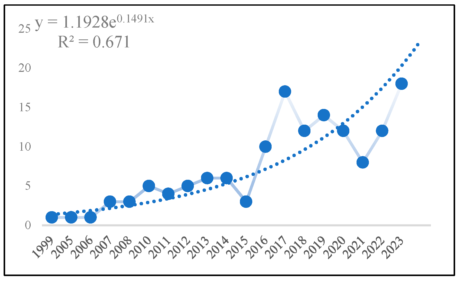
3.1. Analysis of Publishing Trend
This study conducted a statistical analysis of the publication volume, as shown in Figure 2, which revealed an overall upward trend in the research domain of soil permeability at the watershed scale using the SWAT model over the past 25 years. This indicates the current prominence of this domain among researchers. The SWAT model was first used in 1999 to analyze excess rainfall on basin-scale basins(King et al., 1999). Between 1999 and 2004, there was a temporary absence of new research findings in this field. From 2005 to 2017, research in this field showed a stable growth trend, with a total of 64 papers published, approximately 45% of the total literature. During this period, the literature mainly focused on the fields of Water Resources (45 articles), Agriculture (19 articles), Engineering (18 articles), and Environmental Sciences Ecology (16 articles). During the period from 2018 to 2021, a slight decline was observed. However, after 2021, there was a resurgence in publication volume. Additionally, since 2018, there has been increased attention in the fields of Environmental Sciences Ecology, Geology, Meteorology Atmospheric Sciences, and Biodiversity Conservation. This suggests that scholars are increasingly concentrating on the relationship between this field and ecosystems.
Figure 2.
Volume of literature analyzing soil infiltration at the watershed scale using the SWAT model from 1999 to 2023 * The closer "R2" is to 1 in the graph, the more plausible the data i.
Figure 2.
Volume of literature analyzing soil infiltration at the watershed scale using the SWAT model from 1999 to 2023 * The closer "R2" is to 1 in the graph, the more plausible the data i.
3.2. Analysis of Authors of the Articles
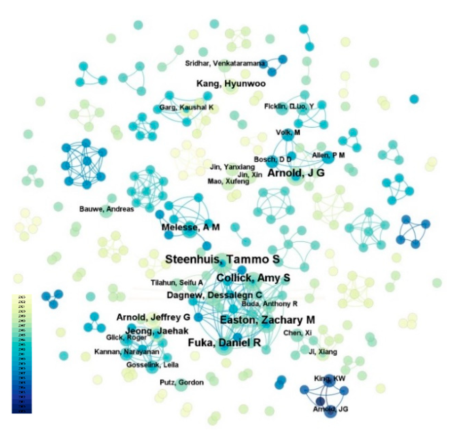
In CiteSpace, the g-index determines the number of nodes (articles, authors, countries, or journals) displayed in network visualization. By adjusting the scaling factor K, the density of the network can be controlled(Wang et al., 2023). In this study, after a series of experiments, we set k=20, and the time slice was configured as 1, which enables the inclusion of nodes representing the most influential authors.
The most prolific author in this field is Steenhuis, Tammo S., with a total of five articles. The second authors are Easton, Zachary M., Fuka, Daniel R., Arnold, J G., Collick, Amy S., each with 4 articles. By setting the note type to “author”, we generated a knowledge graph of the articles' authors (Figure 3). There are 287 nodes, 444 lines, and a network density of 0.0108. Each node represents an author, and larger nodes represent a higher frequency of occurrence; The thicker lines represent a higher degree of cooperation(Romero and Portillo-Salido, 2019). Figure 3 showed that the characteristics of research teams in this field exhibit a state of slight concentration and significant dispersion, with relatively weak inter-team connections.
Figure 3.
Collaborative authorship mapping, 1999-2023.
3.3. Analysis of Country and Institution
In CiteSpace, the network node types were set as “Country” and “Institution”, the time slice was configured as 1, and the threshold was set at k=25. We conducted analyses of collaborative network maps for 41 countries and institutional collaboration maps.
We enumerated the countries and journals demonstrating outstanding academic contributions in this field, as shown in Table 1. Among the top five countries, there are three developed and two developing nations. The United States has published the most published studies(72 articles), followed by China, Ethiopia, Canada, and Germany. Based on Figure 4 (National collaboration mapping), it can be observed that countries with different levels of development exhibit varying attitudes towards collaboration in using the “SWAT” model for watershed soil infiltration analysis. Developed countries typically have a positive attitude towards scientific collaboration in this field, supported by a strong research foundation and substantial investment in collaborative research efforts. The United States played an intermediary role in the national collaboration network, indicating deeper collaborative relationships with other regions in this field and a significantly leading position. China followed closely behind. Secondly, we identified that the top five institutions collectively published 61 articles (Table 1). Among them, four institutions are located in the United States. They are the United States Department of Agriculture (USDA) (14 articles), Cornell University (9 articles), Agricultural Research Service (6 articles), and Purdue University (6 articles). Additionally, two institutions are based in China: Chinese Academy of Sciences (13 articles) and Beijing Normal University (7 articles). This indicated that academic institutions in the United States hold a prominent position in researching soil infiltration at the watershed scale using the SWAT model, followed by China. Bahir Dar University (6 articles) in Ethiopia is also one of the main contributing institutions. These research institutions have formed relatively dense collaborative networks. While there are still a significant number of institutions operating independently in their research endeavors(Figure 5).
Figure 4.
National collaborative mapping, 1999-2023. (Node size represents the number of publications that originated from the country, and the purple rings and their thickness indicate high centrality).
Figure 4.
National collaborative mapping, 1999-2023. (Node size represents the number of publications that originated from the country, and the purple rings and their thickness indicate high centrality).
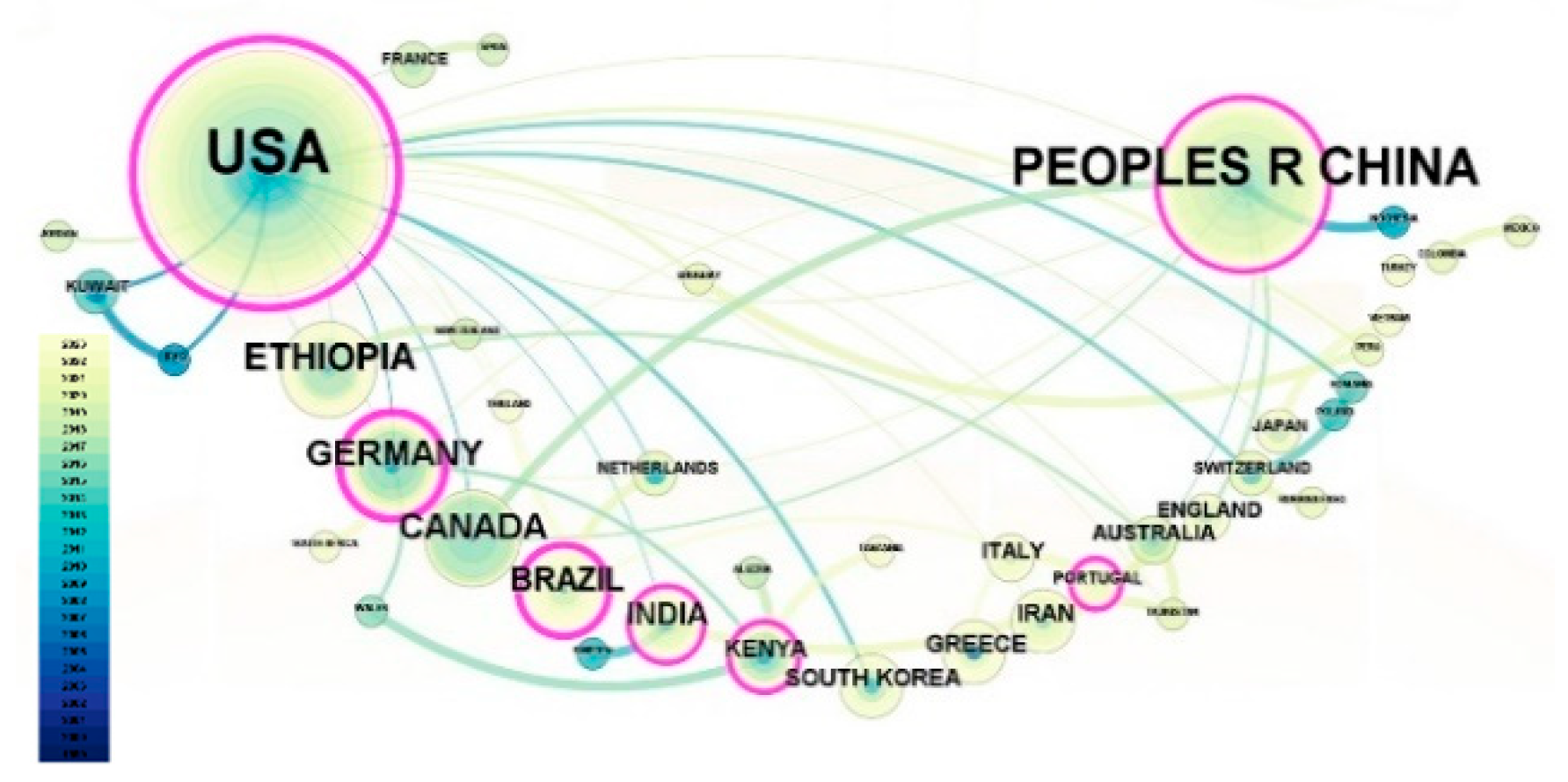
Figure 5.
Institutional collaborative mapping, 1999-2023. (Node size represents the number of publications that originated from the country, and the purple rings and their thickness indicate high centrality).
Figure 5.
Institutional collaborative mapping, 1999-2023. (Node size represents the number of publications that originated from the country, and the purple rings and their thickness indicate high centrality).
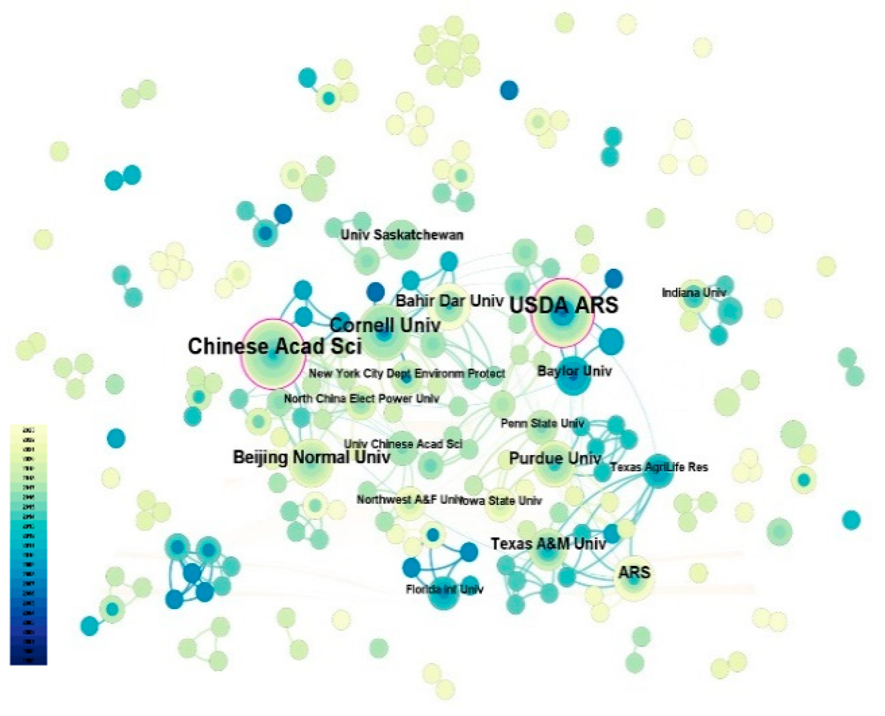

Table 1.
Top 5 countries and institutions in the literature on soil infiltration in watersheds scale using the SWAT model, 1999–2023.
Table 1.
Top 5 countries and institutions in the literature on soil infiltration in watersheds scale using the SWAT model, 1999–2023.
| Country ranking | Institution ranking | ||||
|---|---|---|---|---|---|
| Country | Publications | Institution | Publications | ||
| 1 | USA | 72 | 1 | United States Department of Agriculture (USDA) | 14 |
| 2 | China | 35 | 2 | Chinese Academy of Sciences | 13 |
| 3 | Ethiopia | 12 | 3 | Cornell University | 9 |
| 4 | Canada | 10 | 4 | Beijing Normal University | 7 |
| 5 | Germany | 10 | 5 | Agricultural Research Service | 6 |
| 5 | Purdue University | 6 | |||
| 5 | Bahir Dar University | 6 | |||
3.4. Analysis of Journal Co-Citation
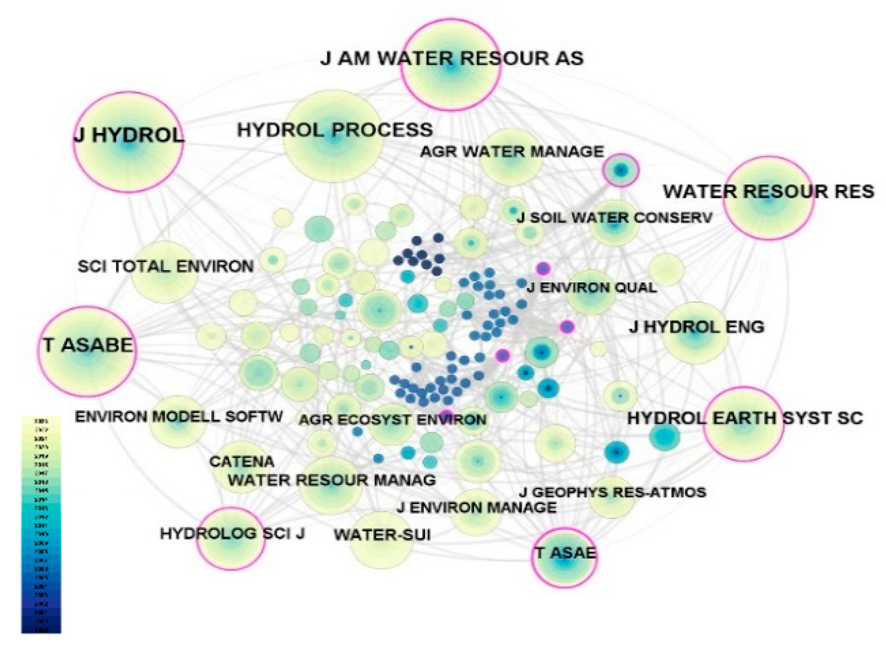
To provide an overview of the types of journals that have served the field of soil infiltration research at the watershed scale using the SWAT model during the period 1999-2023, we conducted a journal co-citation analysis(with threshold k=5, time slice=1) of the retrieved literature as demonstrated in Figure 6. The majority of the cited journals have relatively high impact factors, indicating a certain level of scholarly attention towards research related to watershed-scale soil infiltration analysis using the SWAT model. This provides a theoretical foundation for further scientific advancement in this field and its related research directions in the future. As shown in Figure 6, the journal with the highest number of citations is the Journal of Hydrology (133), followed by Hydrological Processes (115) and Journal of the American Water Resources Association (115). Moreover, research in this field spans various disciplines including Earth science, environmental science, agricultural and forestry science, ecology, soil science, water resources, and hydrological management.
Figure 6.
Journal co-citation analysis mapping, 1999-2023. (Node size indicates the number of citations originating from the journal, and the purple rings and their thickness indicate high centrality.).
Figure 6.
Journal co-citation analysis mapping, 1999-2023. (Node size indicates the number of citations originating from the journal, and the purple rings and their thickness indicate high centrality.).
3.5. Landmark Literature
Table 2 listed the top 10 articles and the main research contents ranked by citation count in the Web of Science Core Collection database (with Science Citation Index Expanded only). The study by Mango et al. (2011) utilized the SWAT model to investigate the impact of land use and climate change on hydrology in the upper Mara River Basin in Kenya. It has been cited 299 times, making it the most cited paper in the research database. The paper proposed improvements in land management practices to enhance soil infiltration and aquifer recharge, thereby better adapting to widespread climate change. The papers by Easton et al. (2008) and J. G. Arnold et al. (2010) follow closely, cited 219 and 146 times, respectively. They revised and updated the traditional SWAT model to better reflect the controls on infiltration, runoff, and groundwater flow.
Table 2.
Top 10 articles based on global citation.
| Reference | Type | Citations | Main Content |
|---|---|---|---|
| Mango et al. (2011) | Article | 299 | The study proposed emphasizing further improvements in land management practices to enhance soil infiltration and aquifer recharge, thereby better adapting to widespread climate change. |
| Easton et al. (2008) | Article | 219 | The paper revised the definitions of curve number (CN) and available soil water content in the traditional SWAT model, constructing the SWAT-VSA new model. This novel model improves the prediction of shallow groundwater depth and runoff source distribution. Such advancements hold significant importance for evaluating and guiding watershed management practices. |
| J. G. Arnold et al. (2010) | Article | 146 | This study enhanced the Soil and Water Assessment Tool (SWAT) watershed model, to more accurately reflect the complex controls on infiltration, runoff generation, and surface and groundwater flow. |
| King et al. (1999) | Article | 137 | The paper incorporated the GAML excess rainfall method and a sub-daily routing technique into the SWAT model to meet the need for other excess rainfall in agriculture-based watershed-scale modeling. |
| Jeong et al. (2010) | Article | 126 | The paper introduced the development and testing of a sub-hourly rainfall-runoff model in SWAT. Statistical results indicate that the sub-hourly version of SWAT is a promising tool for hydrological and nonpoint source pollution assessment, although further development is needed for water quality modeling. |
| Ayele et al. (2017) | Article | 108 | The paper calibrated and validated the SWAT model to study the prioritization of watershed management in the Upper Blue Nile River Basin in Ethiopia, and showed that cropland alters surface infiltration and runoff characteristics as well as the interaction of shallow water table and saturated excess runoff, which in turn affects water and sediment transport trajectories. |
| Luo et al. (2012) | Article | 101 | The paper was based on the single reservoir baseflow approach in the SWAT model to add a slow-reacting reservoir and apply it to the Manas River Basin in the Tianshan Mountains, Northwest China. |
| Garg et al. (2012) | Article | 94 | The paper utilized the ARCSWAT model (a hydrological model for agricultural water intervention) to simulate the effects of various soil and water management interventions compared to non-intervention scenarios in the Kothapally watershed in India. It indicated that intervention measures enhance soil infiltration and water retention capacity, resulting in positive impacts on hydrology. |
| White et al. (2011) | Article | 93 | The paper highlights that in the headwaters of the Blue Nile in Ethiopia, the flow predicted using the new physically based water balance SWAT (SWAT-WB) was better than the original CN-based SWAT (SWAT-CN), and its water balance provided better results than CN. |
| Han et al. (2012) | Article | 91 | The paper integrated the SWAT model with EnKF and a watershed-scale semi-distributed hydrological model to study how assimilating surface soil hydrological data affects hydrological processes. It suggested that remote sensing surface soil moisture measurements have the potential to be applied in watershed-scale water resources management. |
In research centered around the SWAT model, Jeong et al. (2010) developed a sub-hourly rainfall-runoff model within SWAT for hydrological and nonpoint source pollution assessment. Luo et al. (2012) introduced a slow-reacting reservoir baseflow method into the traditional SWAT model to simulate flow processes. White et al. (2011) developed a new physically-based water balance SWAT-WB model, which could provide better simulation results for water balance in specific areas compared to the traditional SWAT-CN.
Additionally, King et al. (1999), Ayele et al. (2017), and Garg et al. (2012) applied the SWAT method to watershed-scale modeling in agriculture, investigating surface infiltration and runoff characteristics under agricultural land conditions. Han et al. (2012) proposed an analytical framework that combined the SWAT model with Ensemble Kalman Filter (EnKF) and a watershed-scale semi-distributed hydrological model to study how assimilating surface soil hydrological data affects hydrological processes.
From the top ten most cited articles, we found that the SWAT model plays a crucial role in analyzing watershed soil permeability. In the future, greater attention should be given to the development and utilization of the SWAT model, as well as its integration with other models, to better reflect processes such as soil permeability and runoff. This will enhance the protection, development, utilization, and management of watersheds. Additionally, we conducted a statistical analysis of the journals where the 141 selected papers were published and found that over 30% of the papers came from the three journals: Journal of Hydrology(12%), Water(11%), and Hydrological Processes(10%). This reflected the leading position of these three journals in the field.
Figure 7.
Keyword co-occurrence network mapping, 1999-2023. (The node size indicates the frequency of occurrence of the keyword, and the purple rings and their thickness indicate high centrality.).
Figure 7.
Keyword co-occurrence network mapping, 1999-2023. (The node size indicates the frequency of occurrence of the keyword, and the purple rings and their thickness indicate high centrality.).

Table 3.
Keyword frequency table (sorted by keyword count and centrality).
| Sorted by Keyword Count | Sorted by Keyword Centrality | ||||||
|---|---|---|---|---|---|---|---|
| Keywords | Count | Centrality | Keywords | Count | Centrality | ||
| 1 | swat model | 36 | 0.11 | 1 | catchment | 20 | 0.29 |
| 2 | runoff | 33 | 0.06 | 2 | calibration | 24 | 0.27 |
| 3 | soil | 32 | 0.11 | 3 | climate change | 23 | 0.23 |
| 4 | river basin | 30 | 0.16 | 4 | model | 25 | 0.19 |
| 5 | model | 25 | 0.19 | 5 | river basin | 30 | 0.16 |
| 6 | calibration | 24 | 0.27 | 6 | flow | 14 | 0.13 |
| 7 | climate change | 23 | 0.23 | 7 | swat model | 36 | 0.11 |
| 8 | catchment | 20 | 0.29 | 8 | soil | 32 | 0.11 |
| 9 | swat | 19 | 0.08 | 8 | land use | 10 | 0.11 |
| 10 | infiltration | 17 | 0.07 | 10 | assessment tool | 12 | 0.09 |
3.6. Research Contents
3.6.1. Keyword Co-Occurrence Analysis
Keywords represent the core themes of an article, with higher frequencies indicating the prevailing research hotspots and focal points at that time(Huang et al., 2021). In the CiteSpace analysis, the network node type is set as “keyword”, with time slice calibration set to 1 year, and the threshold was set to k=20. Figure 7 showed the co-occurrence network of keywords in the research field (1999-2023). The graph comprises 271 nodes and 999 lines, with a density of 0.0273. The size of each node is proportional to the frequency of the corresponding keyword. The purple rings represent nodes with high median centrality and its thickness reflects the centrality value. Table 3 lists the top 10 keywords based on frequency and intermediary centrality. The results indicate that the “SWAT model” is the most frequently occurring keyword (36 times), followed by “runoff” (33 times), “soil” (32 times), and “river basin”(30 times). The keyword with the highest intermediary centrality is “catchment” (0.29), followed by “calibration” (0.27), suggesting that the focal point of research in this field may lie in enhancing water and soil conservation capabilities. Furthermore, keywords such as “climate change” and “infiltration” exhibit high occurrence frequencies and certain mediated centrality, confirming that two themes should be focal points of attention in this field regardless of the indicator used.
3.6.2. Keywords with the Strongest Citation Bursts
CiteSpace ranks prominently displayed keywords based on their burst strength, indicating the significance of these research directions(Su and Lee, 2010). Setting γ=0.54, we draw the keyword burst detection graph for this field (Figure 8). The picture displayed the top 20 keywords along with their strength, burst start time, and end time. The blue line represents time intervals, while the red line represents the period when the use of the keyword increased significantly. To accurately analyze the current status and development trends of the research field of “soil infiltration at the watershed scale using the SWAT model”, we divided the entire research period into three stages.
Figure 8.
Top 20 keywords with the strongest citation bursts.
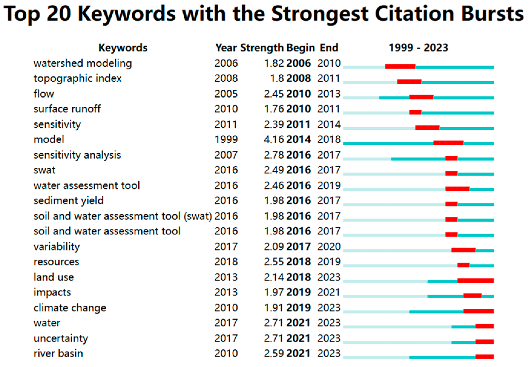
From 1999 to 2004, the research was in an initial stage, and there was a period of research stagnation between 2000 and 2004. The key term during this period was only “model”. Researchers focused on the demand for modeling excessive rainfall at the watershed scale based on agriculture(King et al., 1999). This period laid the foundation for subsequent studies on watershed-scale modeling, providing a reference for future research articles.
From 2005 to 2017, the research was in a developmental stage, with a considerable amount of studies and the emergence of numerous key terms, including “topographic index”, “flow”, and “sensitivity”, being observed at high frequencies. During this stage, researchers primarily focused on adjusting and updating the SWAT model to analyze hydrological components at the watershed scale, simulate precipitation-runoff processes, and enhance control over infiltration, runoff, and groundwater flow. In terms of study subjects, the focus was mainly on analyzing agricultural watersheds(X. Wang et al., 2008; Migliaccio and Srivastava, 2007), watershed divides into hilly or valley areas(J. G. Arnold et al., 2010), and grasslands or forest buffer zones around watersheds(Ma et al., 2010; Bosch et al., 2010). Notably, Ma et al. (2010) proposed that “In the short and medium term, changes in land cover have a greater impact on river water than climate change”.
From 2018-2023, the research was in a boom stage, “land use” and “climate change” garnered widespread attention, and emergent terms have not yet ended. This suggests that these terms may represent new topics and even the primary forefront of the field. The World Meteorological Organization (WMO) released the WMO Statement on the State of the Global Climate in 2019, which highlighted that 2019 witnessed frequent and severe heatwaves, extreme weather events that affect the distribution of rainfall, significantly impacting health, food security, and water security, as well as human production, livelihoods, infrastructure, and biodiversity(WMO, 2020). The “global climate indicators” encompass atmospheric components and energy changes due to the accumulation of greenhouse gases and other factors and responses from land, oceans, and ice(WMO, 2020). The United Nations’ “World Water Development Report 2023” stated that ensuring water resources through sustainable water management can mitigate the impacts of climate change and extreme events(WWAP, 2023). At the same time, “climate change”(Tsvetkova and Randhir, 2019), “land use” and “land cover” (Jin et al., 2019) significantly impact the hydrological balance of watershed systems. Land use might have the potential to mitigate and adapt to the effects of climate change(Ross and Randhir, 2022). Furthermore, changes in land use can affect hydrological elements, and proper land use planning can ensure the sustainability of ecosystem services in watersheds(Khorn et al., 2022). Therefore, in future research, there should be an increased focus on the synergistic interactions between “land use”, “climate change” and watershed systems to promote global hydrological cycles, mitigate extreme weather events, and preserve biodiversity.
Analyzed the keywords with the strongest citation bursts, we found three main trends emerging in the research field of “analyzing soil infiltration at the watershed scale using the SWAT model ”: (1) The scale of research is continuously expanding. (2)The research subjects are diversified, ranging from initially focusing on agricultural watersheds to surrounding areas such as hillsides, grasslands, and forests. (3) The research content becomes more systematic, emphasizing regional coordination and ecological sustainability. Therefore, in the context of climate change, it is necessary to further explore the rational application of the SWAT model on watershed-scale soil infiltration and its relationship with sustainable ecosystem development.
3.7. Limitations
Similar to other bibliometric studies, this study has some limitations. Firstly, all literature was from the WOS core collection database(with Science Citation Index Expanded only), some information or literature might be lost. Secondly, the terminology used in the literature search was finite, the literature search phase could not identify all relevant studies on soil infiltration research at the watershed scale based on the SWAT analysis method. Thirdly, this study analyzed publication trends, countries, institutions, journals, authors, keywords, and the top ten cited articles; there may exist some deficiencies regarding literature analysis and knowledge graph construction. Nevertheless, the results of this study can provide a clear picture of the current status and trends in the field of soil infiltration research at the watershed scale using the SAWT method. At the same time, we hope that future studies can overcome these limitations and provide a more accurate and comprehensive analysis of the literature in this field; we also hope that future studies can analyze the relevant areas of soil infiltration from multiple perspectives to promote a good ecological environment.
4. Conclusions
This bibliometric analysis analyzed the field of “Soil Infiltration at the Watershed Scale Using the SWAT Model” based on publications from the WOS Core Collection(with Science Citation Index Expanded only) database. We utilized CiteSpace software to analyze this field’s research status, hotspots, and trends. This study revealed that the field of “soil infiltration at the watershed scale using the SWAT model” has garnered widespread attention from scholars worldwide. Over time, there have been a rising trend in the number of publications in this field. The research in this domain was interdisciplinary, spanning various fields such as Earth science, environmental science, agricultural science, and ecology. From the analysis of cited journals and the ranking of citation frequency among the top ten articles, it was evident that Journal of Hydrology and Hydrological Processes were the two most influential journals in this field. Scholars and research institutions from the United States, China, and Ethiopia have made significant contributions to this field. Steenhuis, Tammo S. stood out as a prolific and influential scholar. The current problem is that global research cooperation in this field remains relatively low, emphasizing the urgent need to enhance collaboration among scholars from different countries and institutions to advance the field. “Land use” and “climate change” were currently the hotspots of interest in this field. There exhibited three developmental trends: (1) The scale of research is continuously expanding. (2)The research subjects are diversified, ranging from initially focusing on agricultural watersheds to surrounding areas such as hillsides, grasslands, and forests. (3) The research content becomes more systematic, emphasizing regional coordination and ecological sustainability. In the context of climate change, further exploration of the relationship between the research field of “soil infiltration at the watershed scale using the SWAT model” and ecosystems is warranted. Overall, this study provided a framework for new researchers in the field of soil infiltration at the watershed scale using the SWAT model over the past 25 years. This study provided an objective overview of the research hotspots and development trends in this field, offering valuable insights for future scholars interested in studying soil infiltration at the watershed scale using the SWAT model.
Data Availability Statement
Data will be made available on request.
Acknowledgments
This work was supported by JSPS KAKENHI Grant-in-Aid for Scientific Research (B) (grant number 23H01584), and also supported by the Japan Science and Technology Agency SPRING Project (grant number JPMJSP2136).
References
- Aloui, S.; Mazzoni, A.; Elomri, A.; Aouissi, J.; Boufekane, A.; Zghibi, A. A review of Soil and Water Assessment Tool (SWAT) studies of Mediterranean catchments: Applications, feasibility, and future directions. J. Environ. Manage 2023, 326, 116799. [Google Scholar] [CrossRef] [PubMed]
- Arnold, J.G.; Srinivasan, R.; Muttiah, R.S.; Williams, J.R. Large Area Hydrologic Modeling and Assessment Part I: Model Development1. JAWRA J. Am. Water Resour. Assoc 1998, 34, 73–89. [Google Scholar] [CrossRef]
- Ayele, G.T.; Teshale, E.Z.; Yu, B.; Rutherfurd, I.D.; Jeong, J. Streamflow and Sediment Yield Prediction for Watershed Prioritization in the Upper Blue Nile River Basin, Ethiopia. Water 2017, 9, 782. [Google Scholar] [CrossRef]
- Bieger, K.; Arnold, J.G.; Rathjens, H.; White, M.J.; Bosch, D.D.; Allen, P.M.; Volk, M.; Srinivasan, R. Introduction to SWAT+, A Completely Restructured Version of the Soil and Water Assessment Tool. JAWRA J. Am. Water Resour. Assoc 2017, 53, 115–130. [Google Scholar] [CrossRef]
- Bosch, D.; Arnold, J.; Volk, M.; Allen, P. Simulation of a Low-Gradient Coastal Plain Watershed Using the SWAT Landscape Model. Trans. ASABE Am. Soc. Agric. Biol. Eng 2010, 53, 1445–1456. [Google Scholar] [CrossRef]
- Chen, C. Science Mapping: A Systematic Review of the Literature. J. Data Inf. Sci 2017, 2, 1–40. [Google Scholar] [CrossRef]
- Chen, C.; Ibekwe-SanJuan, F.; Hou, J. The structure and dynamics of cocitation clusters: A multiple-perspective cocitation analysis. J. Am. Soc. Inf. Sci. Technol 2010, 61, 1386–1409. [Google Scholar] [CrossRef]
- Chen, C.; Song, M. Visualizing a field of research: A methodology of systematic scientometric reviews. PLoS ONE 2019, 14, e0223994. [Google Scholar] [CrossRef]
- Das, S.; Deb, P.; Bora, P.K.; Katre, P. Comparison of RUSLE and MMF Soil Loss Models and Evaluation of Catchment Scale Best Management Practices for a Mountainous Watershed in India. Sustainability 2021, 13, 232. [Google Scholar] [CrossRef]
- Desta, H.; Lemma, B. SWAT based hydrological assessment and characterization of Lake Ziway sub-watersheds, Ethiopia. J. Hydrol. Reg. Stud 2017, 13, 122–137. [Google Scholar] [CrossRef]
- Downer, C.W.; Ogden, F.L. Appropriate vertical discretization of Richards’ equation for two-dimensional watershed-scale modelling. Hydrol. Process 2004, 18, 1–22. [Google Scholar] [CrossRef]
- Easton, Z.M.; Fuka, D.R.; Walter, M.T.; Cowan, D.M.; Schneiderman, E.M.; Steenhuis, T.S. Re-conceptualizing the soil and water assessment tool (SWAT) model to predict runoff from variable source areas. J. Hydrol 2008, 348, 279–291. [Google Scholar] [CrossRef]
- Engel, B.A.; Srinivasan, R.; Arnold, J.; Rewerts, C.; Brown, S.J. NONPOINT-SOURCE (NPS) POLLUTION MODELING USING MODELS INTEGRATED WITH GEOGRAPHIC INFORMATION-SYSTEMS (GIS). Water Sci. Technol 1993, 28, 685–690. [Google Scholar] [CrossRef]
- Farajalla, N.S.; Vieux, B.E. Capturing the essential spatial variability in distributed hydrological modelling: Infiltration parameters. Hydrol. Process 1995, 9, 55–68. [Google Scholar] [CrossRef]
- Francesconi, W.; Srinivasan, R.; Pérez-Miñana, E.; Willcock, S.P.; Quintero, M. Using the Soil and Water Assessment Tool (SWAT) to model ecosystem services: A systematic review. J. Hydrol 2016, 535, 625–636. [Google Scholar] [CrossRef]
- Garg, K.K.; Karlberg, L.; Barron, J.; Wani, S.P.; Rockstrom, J. Assessing impacts of agricultural water interventions in the Kothapally watershed, Southern India. Hydrol. Process 2012, 26, 387–404. [Google Scholar] [CrossRef]
- Gassman, P.W.; Sadeghi, A.M.; Srinivasan, R. Applications of the SWAT Model Special Section: Overview and Insights. J. Environ. Qual 2014, 43, 1–8. [Google Scholar] [CrossRef]
- Han, E.; Merwade, V.; Heathman, G.C. Implementation of surface soil moisture data assimilation with watershed scale distributed hydrological model. J. Hydrol. 2012, 416–417, 98–117. [Google Scholar] [CrossRef]
- Hoang, L.; Schneiderman, E.M.; Moore, K.E.B.; Mukundan, R.; Owens, E.M.; Steenhuis, T.S. Predicting saturation-excess runoff distribution with a lumped hillslope model: SWAT-HS. Hydrol. Process 2017, 31, 2226–2243. [Google Scholar] [CrossRef]
- Huang, X.; Wang, K.-R.; Zou, Y.; Cao, X.-C. Development of global soil erosion research at the watershed scale: A bibliometric analysis of the past decade. Environ. Sci. Pollut. Res 2021, 28, 12232–12244. [Google Scholar] [CrossRef]
- Ilstedt, U.; Malmer, A.; Verbeeten, E.; Murdiyarso, D. The effect of afforestation on water infiltration in the tropics: A systematic review and meta-analysis. For. Ecol. Manag., Planted Forests and Water 2007, 251, 45–51. [Google Scholar] [CrossRef]
- Arnold, J.G.; Allen, P.M.; Volk, M.; Williams, J.R.; Bosch, D.D. Assessment of Different Representations of Spatial Variability on SWAT Model Performance. Trans. ASABE 2010, 53, 1433–1443. [Google Scholar] [CrossRef]
- Jeong, J.; Kannan, N.; Arnold, J.; Glick, R.; Gosselink, L.; Srinivasan, R. Development and Integration of Sub-hourly Rainfall–Runoff Modeling Capability Within a Watershed Model. Water Resour. Manag 2010, 24, 4505–4527. [Google Scholar] [CrossRef]
- Jiang, Y.; Hou, L.; Shi, T.; Gui, Q. A Review of Urban Planning Research for Climate Change. Sustainability 2017, 9, 2224. [Google Scholar] [CrossRef]
- Jin, X.; Jin, Y.; Mao, X. Land Use/Cover Change Effects on River Basin Hydrological Processes Based on a Modified Soil and Water Assessment Tool: A Case Study of the Heihe River Basin in Northwest China’s Arid Region. Sustainability 2019, 11, 1072. [Google Scholar] [CrossRef]
- Khorn, N.; Ismail, M.H.; Nurhidayu, S.; Kamarudin, N.; Sulaiman, M.S. Land use/land cover changes and its impact on runoff using SWAT model in the upper Prek Thnot watershed in Cambodia. Environ. Earth Sci 2022, 81, 466. [Google Scholar] [CrossRef]
- King, K.; Arnold, J.; Bingner, R. Comparison of Green-Ampt and Curve Number Methods on Goodwin Creek Watershed Using SWAT. Trans. ASAE 1999, 42. [Google Scholar] [CrossRef]
- Lammers, R.W.; Miller, L.; Bledsoe, B.P. Effects of Design and Climate on Bioretention Effectiveness for Watershed-Scale Hydrologic Benefits. J. Sustain. Water Built Environ 2022, 8, 04022011. [Google Scholar] [CrossRef]
- Langhans, C.; Govers, G.; Diels, J.; Stone, J.J.; Nearing, M.A. Modeling scale-dependent runoff generation in a small semi-arid watershed accounting for rainfall intensity and water depth. Adv. Water Resour 2014, 69, 65–78. [Google Scholar] [CrossRef]
- Leal Filho, W.; Dedeoglu, C.; Dinis, M.A.P.; Salvia, A.L.; Barbir, J.; Voronova, V.; Abubakar, I.R.; Iital, A.; Pachel, K.; Huthoff, F.; Sharifi, A.; Yang, P.J.; Klavins, M.; Emanche, V.O. Riverine Plastic Pollution in Asia: Results from a Bibliometric Assessment. Land 2022, 11, 1117. [Google Scholar] [CrossRef]
- Luo, Y.; Arnold, J.; Allen, P.; Chen, X. Baseflow simulation using SWAT model in an inland river basin in Tianshan Mountains, Northwest China. Hydrol. Earth Syst. Sci 2012, 16, 1259–1267. [Google Scholar] [CrossRef]
- Ma, X.; Xu, J.; van Noordwijk, M. Sensitivity of streamflow from a Himalayan catchment to plausible changes in land cover and climate. Hydrol. Process 2010, 24, 1379–1390. [Google Scholar] [CrossRef]
- Mango, L.M.; Melesse, A.M.; McClain, M.E.; Gann, D.; Setegn, S.G. Land use and climate change impacts on the hydrology of the upper Mara River Basin, Kenya: Results of a modeling study to support better resource management. Hydrol. Earth Syst. Sci 2011, 15, 2245–2258. [Google Scholar] [CrossRef]
- Migliaccio, K.; Srivastava, P. Hydrologic Components of Watershed-Scale Models. Trans. ASABE 2007, 50. [Google Scholar] [CrossRef]
- Organization (WMO), W.M. 2020. WMO Statement on the State of the Global Climate in 2019 [WWW Document]. Available online: https://library.wmo.int/records/item/56228-wmo-statement-on-the-state-of-the-global-climate-in-2019 (accessed on 20 May 2024).
- Gassman, P.W.; Reyes, M.R.; Green, C.H.; Arnold, J.G. . The Soil and Water Assessment Tool: Historical Development, Applications, and Future Research Directions. Trans. ASABE 2007, 50, 1211–1250. [Google Scholar] [CrossRef]
- Qi, J.; Lee, S.; Zhang, X.; Yang, Q.; McCarty, G.W.; Moglen, G.E. Effects of surface runoff and infiltration partition methods on hydrological modeling: A comparison of four schemes in two watersheds in the Northeastern US. J. Hydrol 2020, 581, 124415. [Google Scholar] [CrossRef]
- Riza, S.; Sekine, M.; Kanno, A.; Yamamoto, K.; Imai, T.; Higuchi, T. Modeling soil landscapes and soil textures using hyperscale terrain attributes. Geoderma 2021, 402, 115177. [Google Scholar] [CrossRef]
- Rocha, E.O.; Calijuri, M.L.; Santiago, A.F.; de Assis, L.C.; Alves, L.G.S. The Contribution of Conservation Practices in Reducing Runoff, Soil Loss, and Transport of Nutrients at the Watershed Level. Water Resour. Manag 2012, 26, 3831–3852. [Google Scholar] [CrossRef]
- Romero, L.; Portillo-Salido, E. Trends in Sigma-1 Receptor Research: A 25-Year Bibliometric Analysis. Front. Pharmacol 2019, 10, 564. [Google Scholar] [CrossRef]
- Ross, E.R.; Randhir, T.O. Effects of climate and land use changes on water quantity and quality of coastal watersheds of Narragansett Bay. Sci. Total Environ 2022, 807, 151082. [Google Scholar] [CrossRef]
- Sarangi, A.; Madramootoo, C.A.; Enright, P. Comparison of Spatial Variability Techniques for Runoff Estimation from a Canadian Watershed. Biosyst. Eng 2006, 95, 295–308. [Google Scholar] [CrossRef]
- Starks, P.J.; Ross, J.D.; Heathman, G.C. ; n.d. Modeling the Spatial and Temporal Distribution of Soil Moisture at Watershed Scales Using Remote Sensing and GIS, in: Spatial Methods for Solution of Environmental and Hydrologic Problems—Science, Policy, and Standardization. Presented at the Spatial Methods for Solution of Environmental and Hydrologic Problems—Science, Policy, and Standardization, ASTM International, pp. 58–74. [CrossRef]
- Su, H.-N.; Lee, P.-C. Mapping knowledge structure by keyword co-occurrence: A first look at journal papers in Technology Foresight. Scientometrics 2010, 85, 65–79. [Google Scholar] [CrossRef]
- Sun, D.; Yang, H.; Guan, D.; Yang, M.; Wu, J.; Yuan, F.; Jin, C.; Wang, A.; Zhang, Y. The effects of land use change on soil infiltration capacity in China: A meta-analysis. Sci. Total Environ 2018, 626, 1394–1401. [Google Scholar] [CrossRef] [PubMed]
- Tan, M.L.; Gassman, P.W.; Yang, X.; Haywood, J. A review of SWAT applications, performance and future needs for simulation of hydro-climatic extremes. Adv. Water Resour 2020, 143, 103662. [Google Scholar] [CrossRef]
- Tsvetkova, O.; Randhir, T.O. Spatial and temporal uncertainty in climatic impacts on watershed systems. Sci. Total Environ 2019, 687, 618–633. [Google Scholar] [CrossRef]
- Vieux, B.E. ; 2016. Infiltration, in: Vieux, B.E. (Ed.), Distributed Hydrologic Modeling Using GIS. Springer Netherlands, Dordrecht, pp. 83–99. [CrossRef]
- Walsh, C.J.; Roy, A.H.; Feminella, J.W.; Cottingham, P.D.; Groffman, P.M.; Morgan, R.P. The urban stream syndrome: Current knowledge and the search for a cure. J. North Am. Benthol. Soc 2005, 24, 706–723. [Google Scholar] [CrossRef]
- Wang, M.; Jiang, Z.; Ikram, R.M.A.; Sun, C.; Zhang, M.; Li, J. Global Paradigm Shifts in Urban Stormwater Management Optimization: A Bibliometric Analysis. Water 2023, 15, 4122. [Google Scholar] [CrossRef]
- Wen, C.; Zhen, Z.; Zhang, L.; Yan, C. A bibliometric analysis of river health based on publications in the last three decades. Environ. Sci. Pollut. Res 2023, 30, 15400–15413. [Google Scholar] [CrossRef]
- White, E.D.; Easton, Z.M.; Fuka, D.R.; Collick, A.S.; Adgo, E.; McCartney, M.; Awulachew, S.B.; Selassie, Y.G.; Steenhuis, T.S. Development and application of a physically based landscape water balance in the SWAT model. Hydrol. Process 2011, 25, 915–925. [Google Scholar] [CrossRef]
- World Water Assessment Programme(WWAP). 2023. The United Nations World Water Development Report 2023: partnerships and cooperation for water. UNESCO.[WWW Document]. 2023. Available online: https://unesdoc.unesco.org/ark:/48223/pf0000384655 (accessed on 20 May 2024).
- Wang, X.; Shang, S.; Yang, W.; Melesse, A.M. Simulation of an Agricultural Watershed Using an Improved Curve Number Method in SWAT. Trans. ASABE 2008, 51, 1323–1339. [Google Scholar] [CrossRef]
- Yen, H.; Park, S.; Arnold, J.G.; Srinivasan, R.; Chawanda, C.J.; Wang, R.; Feng, Q.; Wu, J.; Miao, C.; Bieger, K.; Daggupati, P.; Griensven, A. van, Kalin, L.; Lee, S.; Sheshukov, A.Y.; White, M.J.; Yuan, Y.; Yeo, I.-Y.; Zhang, M.; Zhang, X. IPEAT+: A Built-In Optimization and Automatic Calibration Tool of SWAT+. Water 2019, 11, 1681. [Google Scholar] [CrossRef]
- Zhao, J.; Zhang, N. Environmental regulation and labor market: A bibliometric analysis. Environ. Dev. Sustain 2023, 25, 6095–6116. [Google Scholar] [CrossRef]
- Zhao, Y.; Wu, P.; Zhao, S.; Feng, H. Variation of soil infiltrability across a 79-year chronosequence of naturally restored grassland on the Loess Plateau, China. J. Hydrol 2013, 504, 94–103. [Google Scholar] [CrossRef]
Disclaimer/Publisher’s Note: The statements, opinions and data contained in all publications are solely those of the individual author(s) and contributor(s) and not of MDPI and/or the editor(s). MDPI and/or the editor(s) disclaim responsibility for any injury to people or property resulting from any ideas, methods, instructions or products referred to in the content. |
© 2025 by the authors. Licensee MDPI, Basel, Switzerland. This article is an open access article distributed under the terms and conditions of the Creative Commons Attribution (CC BY) license (https://creativecommons.org/licenses/by/4.0/).
Copyright: This open access article is published under a Creative Commons CC BY 4.0 license, which permit the free download, distribution, and reuse, provided that the author and preprint are cited in any reuse.


