
Submitted:
25 April 2025
Posted:
29 April 2025
You are already at the latest version
Abstract
Land use transformation, the longest-standing human-driven environmental alteration, is a pressing and complex issue that significantly impacts European landscapes. It is often described as a dimensional key to “global change”. As the European Environment Agency (EEA) reports, the significant factors influencing land take in the European Economic Area include industrial and commercial activities, alongside the expansion of residential areas, particularly in the vicinity of larger urban agglomerations. This comprehensive study explores the diverse strategies adopted by European countries, including Italy, Greece, Poland, France, and Ukraine, to address the challenge of achieving zero net land take by 2050. This involves thoroughly examining the countries' laws, strategies, and targets for neutrality in land degradation. The potential impact of this study on policymakers, land-use planners, and academic institutions is significant, as it aims to foster a comprehensive understanding of the existing gaps, practical implementation challenges, and inconsistencies in national laws. Ultimately, the research aims to yield essential insights, underscoring the crucial role of these stakeholders in sustainable land use development. Among the results, it has become evident that a typical “pathway” between the examined states in terms of legislative framework on land use–land take is probably a utopia for the time being. The legislations in force, in several cases, are labyrinthine and multifaceted, highlighting the urgent and immediate need for simplification and standardization. The need for this action is further underscored by the fact that, in most cases, land use frameworks are characterized by complementary legislation and ongoing amendments. Notably, deregulated land-use planning and development occur in certain instances within Southern Europe. To a further extent, the structure, role, and implementation of legislations rest within different levels of legislative entities, thus giving a wide range of complexity, diversity, and goals depending on who legislates each case.
Keywords:
land use
; land degradation neutrality
; urbanization
; soil strategy 2030
; land use—land use change
; and forestry (LULUCF)
1. Introduction
Land use change, defined as the modification of land from one use to another, plays a vital role in shaping environmental, socio-economic, and territorial dynamics. This process includes various transformations such as the intensification of agriculture, reforestation initiatives, and urban expansion. Such changes have a profound effect on climate regulation, the integrity of biodiversity, and the resilience of food systems, thereby serving as a crucial element in both environmental degradation and the prospects for sustainable transitions. Originating from agronomy, the term land-take refers to investigating factors responsible for the loss of agricultural land [1]. It is regarded as a critical phenomenon that plays a role in numerous environmental challenges, such as soil sealing, declining biodiversity, erosion, soil degradation, flooding, and desertification. Additionally, land-take is perceived as a factor that aggravates the consequences of climate change and leads to indirect modifications in land use. The complex interrelations of previously outlined processes often render delineating conceptual boundaries challenging. Land-take is associated with urbanization and the development of artificial surfaces, suggesting a progressive increase in settlement areas or artificial surfaces over time, usually at the cost of rural landscapes [2].
As the world’s most developed and urbanized continent, Europe has undergone significant land-use transformations, primarily driven by urbanization and industrialization, resulting in a steady decline in cropland and a moderate increase in forested areas and pastures [3,4,5]. Mediterranean landscapes are an example, as they have safeguarded a diverse agricultural heritage for many years. However, this has been increasingly compromised by the spread of dispersed and spatially discontinuous urbanization, especially around cities [6].
The ongoing trend of urban sprawl, a primary concern for European metropolitan structures and socio-economic activities [7] has significant implications. Urban sprawl and land-use transformations have been manifested differently across various countries, driven by localized factors tied to geographical, demographic, and socio-economic conditions, along with the historical, political, and cultural narratives of each area [8]. For instance, the residential sprawl observed in many British and French cities contrasts sharply with the semi-dense, unregulated urbanization patterns in southern Europe and the highly regulated, compact urban models in eastern European cities [9]. As Europe becomes increasingly susceptible to natural disasters, it is essential to mitigate biodiversity loss, adapt to climate change, and halt land degradation by rehabilitating wetlands, peatlands, coastal ecosystems, forests, grasslands, and agricultural lands. Between 2012 and 2018 (Figure 1), urban areas in the EU-27 and the UK experienced a land take of 3,581km², accompanied by an estimated increase in soil sealing of 1,467km², mainly at the expense of croplands and pastures. This soil sealing has resulted in a loss of potential carbon sequestration, quantified at approximately 4.2 million tons of carbon during the observed period. Notably, almost 80% of the land appropriated in urban settings was situated in commuting zones, vital for wildlife habitats, carbon storage, flood mitigation, and food production [10].
Currently, the EU lacks a legally binding policy target for land-take. However, the new EU Soil Strategy 2030 requires Member States (MS) to establish land-take targets for 2030 to attain neutrality by 2050 [10]. Recognizing that the EU does not have direct control over spatial planning is essential. Even though the EU’s role is limited to defining the regulatory framework and potential restrictions in this area, it grants MS considerable autonomy in developing their legislative frameworks for spatial planning. To illustrate, specific MS have outlined their aims for reducing land take. In 2002, Austria committed to significantly decreasing land-take, aiming to drop it from 0.25km² per day to 0.025km² per day by 2020. In 2002, Switzerland also set a goal to limit land consumption to 400m² per person gradually. In contrast, Germany emphasized the preservation of agricultural land for food production and established a target of 0.3 km² per day by 2020, as indicated in its 2016 report [2]. On the contrary, Poland’s agricultural land conversion rates are currently among the highest in Europe [11]. Such alterations in land use and the depletion of soil resources may lead to irreversible consequences for fragile landscapes, influencing or entrenching inequalities in access to high-quality soils among different actors [12]. Thus, the soil consumption resulting from urbanization can be interpreted as a spatial justice concern, notably when it modifies the distribution of high-quality soils along the urban continuum [13]. Studies have shown that soil resource depletion is associated with territorial disparities, economic underdevelopment, poverty, and increased human pressure on sensitive rural areas [14].
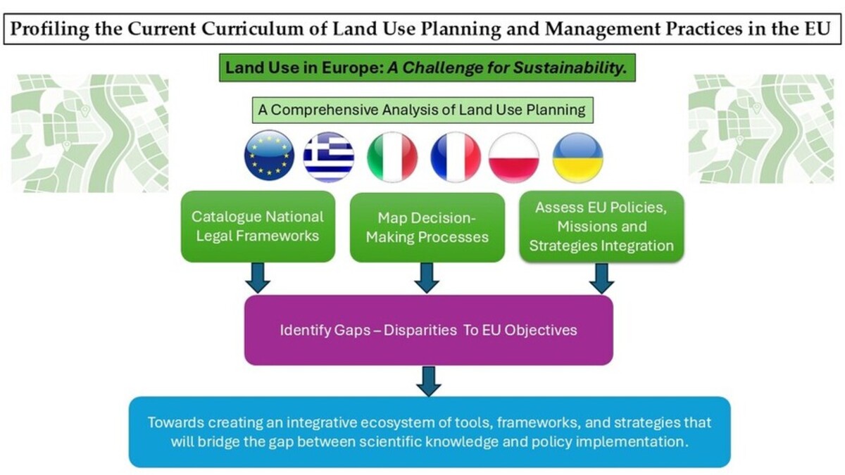
This study intends to illuminate the conceptual distinctions among diverse legal frameworks and provisions related to land use in the five countries examined. The research scope has been explicitly identified and articulated, focusing on providing a detailed exploration of the national legislative frameworks related to soil consumption and land use alterations. The primary aim of this study is to delineate the key provisions, highlight the distinctions among various regulations, and identify any significant gaps or deficiencies. In summary, this study seeks to contribute to the ongoing dialogue on how legal provisions can be improved to efficiently address the evolving land use challenges in a rapidly changing world.
2. Materials and Methods
A comprehensive review of the literature and regulatory sources provided a wide-ranging overview of the existing legal frameworks, concentrating on the contrasting approaches to land-use matters. The keywords selected to conduct the analysis were “land use management,” “land use–land take,” “land-use change,” “land-use, land cover (LULC),” and “land degradation”. The study incorporated a wide array of resources, including official websites of relevant government ministries, legislative databases such as those of the European Parliament, legal databases like Eur-Lex, FAO-Lex, Normattiva, the official portal of the Parliament of Ukraine, as well as research through platforms like Google Scholar and European databases, including the official website of the EU and the EEA. The timeframe for the above search was set between 2018 and the present to capture and derive the most updated results. Overall, the study presents a comprehensive assessment of land-use regulations, highlighting key challenges and emphasizing the need for robust, transparent, and harmonized guidelines to effectively support sustainable land-use planning.
3. Results
Land use and land cover are closely related, with land use acting as a catalyst for changes in land cover [15]. Human activities associated with land use significantly impact the characteristics and processes, resulting in ongoing transformations of land cover. Consequently, alterations in land use or unsustainable management practices affect the supply of services, impacting not just individual services but the entire ecosystem [16]. In 2018, the EU set Regulation 2018/841 regarding greenhouse gas emissions (GHG) and Land Use, Land Use Change, and Forestry (LULUCF) removals. Among the targets set for 2030, the GHG removal is expected to be 310 million tons of CO2 equivalent. The regulation emphasizes the enhancement of governance, the promotion of transparency, and the strengthening of the connection between climate mitigation initiatives and environmental protection policies1. The newly adopted Regulation 2023/839 of 19 April 2023 has already been amended. In conjunction with the Directorate-General for Climate Action and the EEA, the EU has assigned a consortium of contractors to create a Handbook2 to support the execution of the updated regulation. This Handbook delivers practical insights, examples, and case studies from MS. It incorporates the latest methodologies and monitoring data to enhance the reliability of GHG emissions and removals within the LULUCF sector’s emission inventory. Moreover, it promotes disseminating knowledge and experiences to strengthen GHG monitoring in the land sector, ensuring that it accurately represents the effects of various policies and measures. The initial edition of the Handbook was introduced in December 2023 during a workshop held in Copenhagen.
From an international perspective, the United Nations Sustainable Development Goals (SDGs) for 2030, which aim towards climate neutrality, have incorporated Land Degradation Neutrality (LDN) into target 15.3. The target supports other targets, such as SDG Target 11.3, which addresses sustainable urban development, and SDG Target 15.1, referring to ecosystem conservation and restoration [17]. The notion of LDN was brought into the global discourse to foster a more robust policy response to the challenges of land degradation and, based on UNCCD, 2016, is “a state whereby the amount and quality of land resources necessary to support ecosystem functions and services and enhance food security remain stable or increase within specified temporal and spatial scales and ecosystems” [18]. The pursuit of LDN involves a strategic alignment of actions that include a) preventing the degradation of healthy land, b) lessening the degree of land degradation, and c) restoring or rehabilitating degraded land [19]. Table 1 presents all relevant EU missions, strategies addressing land degradation, and the target commitments.
Various factors, including agroclimatic conditions, historical land uses, deregulation of land use and cover, socioeconomic factors, and land management schemes, significantly influence the patterns of land systems in the EU. Historical land use significantly influences the current condition of land systems, with effects that can last for decades or even centuries [20]. For instance, the eastern border of Germany experienced its first wave of agricultural intensification in the late nineteenth century, characterized by extensive farming estates [21]. In contrast, neighboring Polish regions were dominated by family and small-scale farming, a difference that is still apparent today. These Polish areas exhibit high-intensity management systems, particularly in crop production and forestry. Agroclimatic conditions also significantly influence the patterns of land systems in Europe. Despite the introduction of technological innovations and significant investments to counteract these conditions, such as drainage, fertilization, and irrigation, agroclimatic factors continue to be a key determinant of land-use intensity. Delving deeper, the urbanization trends are notably strong in certain European areas, particularly along coastal regions and Western Europe, often accompanied by the abandonment and declining intensity of land use in the hinterlands. This situation can be partially linked to rural-urban migration, driven by rising per capita GDP in urban areas and diminishing income opportunities in rural regions [22]. Such trends have been observed in Italy [23], the Mediterranean [24], Switzerland [25] and Eastern Europe [26]. Consequently, the phenomenon of abandonment in Europe can be divided into two main types: (a) the rural exodus type, where urbanization and reduced income opportunities in rural areas lead to abandonment, especially in mountainous and Mediterranean regions, and (b) the post-socialist type, triggered by significant socio-economic and institutional changes after 1990. Both trends occurred in Eastern Europe.
Other factors, such as transferring land-based production to regions outside the EU, significantly influence the stability of Europe’s land systems. The “outsourcing” of agricultural activities to areas with lower production costs now constitutes roughly one-third of the land required to meet Europe’s demands [27]. Finally, the deregulated urban development, especially prominent in Italy and Greece, in conjunction with ineffective land management, has sometimes caused a divergence in the quality of natural resources, which could influence the socio-ecological conditions in the area [28]. Historically, Mediterranean regions have relied on low-quality soils to support forests and pastures, with fertile soils dedicated to agriculture. However, urban expansion increasingly competes with agricultural land for these high-quality soils [29]. This trend has had a detrimental impact on the economic health of the primary sector and the sustainable delivery of vital ecosystem services in peri-urban settings [30].
Table 2 systematically presents the five countries’ legislative frameworks, highlighting their respective targets and goals for minimizing land-take. The accompanying data and information delineate the critical articles and chapters of the laws and the rationale behind their creation.
According to the findings of Chatzitheodoridis et al. (2024), Greece is notable for its lack of a unified national urban strategy and a “non-planning” heritage [31]. Various studies have pointed out the deficiencies in spatial planning within Greece, highlighting the ineffectiveness of enforcing building and planning regulations and the notably protracted timeline for land use plan approvals [32]-[33]. The state does not systematically and intentionally select which regions to govern through spatial planning. Instead, it tends to respond in a fragmented manner, often reflecting on past actions rather than planning proactively [34]. Due to remarkable urban sprawl over thirty years spanning from 1990 to 2018, the country’s rapid and uncontrolled land change has significantly altered more than 1,700 km², from rural and forested lands into urban uses. If this trajectory continues, urban land coverage is expected to double the extent recorded in 1990 by 2030 [35]. The national government assumes the most significant responsibilities in Greece’s multifaceted spatial planning system. It manages the essential legislative framework concerning regional and urban planning, environmental safeguarding, and regional development initiatives. Additionally, the authority endorses almost all spatial plans implemented throughout the country. Of the 25 distinct types of spatial plans available, 22 have been officially supported by the national government. The role of regions in land use is largely restricted. They primarily engage in advisory capacities, assisting in formulating various spatial planning documents [36]. In the same report, the OECD notes that many spatial plans remain in effect despite being replaced by recent ones, resulting in considerable convergence between the various plans.
Italy is a unitary country; nonetheless, its land-use planning system adopts characteristics commonly associated with federal structures. The primary legal guidelines governing the planning process are derived from regional laws and regulations. Municipalities play a crucial role in determining land use at the local level, primarily through implementing the Local Development Plan (LDP) [37]. In 1942, the national legal framework established a three-level planning system, comprising regional plans (Piano Territoriale di Coordinamento Regionale- PTCR), commonly integrated into a web-GIS data system called SITAP30, founded in 1996, which focuses on the management, consultation, and distribution of information concerning restricted areas as per the prevailing landscape protection legislation. The second tier of the hierarchy pertains to the provincial plans, known as the Piano Territoriale di Coordinamento Provinciale (PTCP), while the third tier is associated with municipal planning. The aforementioned plans are implemented in conjunction with the Piano di Assetto Idrogeologico– PAI, which aims to mitigate hydrogeological risk while ensuring compatibility with existing land uses, thereby protecting public safety and reducing potential damage to vulnerable properties. This system provided an overarching regulatory context for the local plan (Piano Regolatore Generale- PRG), incorporating zoning stipulations [38]. The LDP delineates strategies designed to protect and improve the landscape, potentially imposing restrictions on the nature and scale of development permitted in areas recognized for their natural, cultural, or historical importance. This legal framework for planning in Italy has been in effect since 1942. The system was initially established to control the outward spread of urban agglomerations, with a strong emphasis on expropriation and public development efforts. Although later reforms and court decisions have reduced this emphasis, the LDP has remained fundamentally unchanged as the primary planning instrument [37].
Italy does not possess a national law dedicated to reducing land-take or revitalizing urban environments. Since 1970, however, it has delegated all legislative and executive functions of these areas to the Regions, which enact their laws (Leggi Regionali Urbanistiche) delineating urban planning procedures. A case in point is the Basilicata Regional Planning Law (L.R. 23/199931), which oversees territorial planning to ensure the robust protection of natural and cultural resources, facilitate effective urban regeneration, and support the establishment of resilient infrastructure. The lack of a unified strategy has resulted in regional laws exhibiting considerable variation in scope and detail. Each region may have numerous plans that cover the full extent of the regional area, specific conservation zones, and a wide array of municipal land use plans [39]. Differing regulations, geographical scopes, and designated authorities characterize these plans. The overarching goal of most existing laws in Italy, which vary by region concerning land use management, does not emphasize planning as a fundamental aspect. Instead, it views urban regeneration primarily as enhancing specific segments of urbanized land, achieved through physical-spatial and urban development planning, sometimes supported by volumetric or economic incentives [40].
In France, the challenges associated with land use planning are multifaceted, mainly stemming from the inherent discord within a governance system that features a dominant national government actively involved in nearly all areas of French society, juxtaposed with a strong tradition of local democracy. This dynamic has given rise to many elected local governments, commonly known as communes [41]. Land use planning is merely one of the many responsibilities that these governmental entities manage. France’s planning system has traditionally been characterized as a “regional economic” approach, which seeks to achieve various social and economic objectives, particularly in addressing regional disparities in wealth, employment, and social conditions [42]. Recently, this system has begun to evolve towards a “comprehensive, integrated” approach, emphasizing spatial coordination through a hierarchy of plans, moving away from a primary focus on economic development [42]. Until the 2000s, the predominant purpose of spatial planning in France was to orchestrate urban development and locate economic activities. Today, however, the focus has shifted towards curbing urban sprawl, conserving natural and agricultural environments, and steering development to prioritise energy efficiency, resulting in lower GHG emissions [43]. France’s approach to spatial planning is increasingly characterized by an integrated framework that spans several thematic areas, including ecosystem protection, climate change adaptation and mitigation, and land use management. Moreover, there is a significant focus on comprehensive strategies that advocate for inter-municipal planning initiatives [41]. France does not have a comprehensive national spatial planning system; the country utilizes only sectoral guidelines articulated through the Schémas de Services Collectifs (SSC) [44]. Established in 2000, the Schéma de Cohérence Territoriale (SCoT) functions as the essential document at the local level. Voluntary groups of municipalities formulated it, including the Projet d’Aménagement et de Développement Durable (PAAD), which tackles essential concerns regarding spatial quality and environmental protection [45]. Within macro-regional planning, the Directive Territoriale d’Aménagement (DTA) is an obligatory instrument to tackle the pressing environmental challenges encountered in expansive natural territories, including areas such as the Alpes Maritimes [46].
The evolution of spatial planning in Poland over the last twenty-five years has been marked by a significant shift from a centrally planned, communal land tenure system under socialism to a decentralized and privatized approach within a market economy. Currently, the planning landscape encompasses national, regional, and local levels, where higher-order plans guide the more detailed lower-order plans. The national spatial policy articulates the overarching goals and objectives of the nation’s spatial development. It establishes a general planning framework and clarifies the responsibilities of subnational governments. Subsequently, regional authorities are tasked with creating more comprehensive plans and coordinating substantial public investments. Local governments, in turn, produce local spatial development plans that contain the most intricate details regarding specific land uses, policies, and practices. Despite this, the Polish planning system contains various inconsistencies contributing to suboptimal planning outcomes. Notable issues include a) the frequent invocation of special infrastructural acts by the national government, which effectively suspend local planning laws, b) the existence of areas devoid of local spatial development plans, which are instead governed by isolated planning decisions and c) the establishment of Special Economic Zones (SEZ) that lack alignment with local spatial objectives [47].
In Poland, the structure of subnational government is organized into three levels: voivodeships (provinces), powiats (counties or districts), and gminas (communes or municipalities). The 16 voivodeships are predominantly based on historical regions. The country is further divided into 379 powiats, which include 65 cities that are granted powiat status, and 2,479 gminas. Each level serves distinct political and administrative purposes, with essential differences in their functions. The regional level incorporates both regional self-governances. The coordination of regional-level planning, encompassing aspects such as infrastructure, cultural development, and environmental protection, falls under the purview of regional governments. These authorities create comprehensive regional spatial development plans and strategies that cover the entire territory of the voivodeship. Nonetheless, the non-binding nature of these plans on municipalities restricts their practical impact [47]. Between 2002 and 2016, Poland experienced significant changes in land use, with a decline of over 541,000 hectares in agricultural land and an increase of more than 568,000 hectares in forest land, as reported by cadastral statistics [48]. An issue that needs to be highlighted concerns the overly vague definitions of land use classifications, as identified by Kwartalnik-Pruc, which hinder the practical enforcement of legal provisions [49]. The challenge is not limited to land use classification within Poland; instead, it involves many datasets and indicators informed by geographical and statistical data about land use and land cover. In a similar vein, Marquard et al. [44], along with Bielecka and Jenerowicz [49], suggested that developing a more precise conceptualization of land-take and its related concepts could significantly aid in understanding the complexities of the issue, thereby enhancing monitoring efforts and facilitating communication among countries.
Ukraine has undergone excessive transformations in land use and land cover dynamics following the dissolution of the Soviet Union in 1991 [50]. Given that around 70% of Ukraine’s territory is allocated to agricultural activities, the alterations within this sector have been remarkably significant. In the past five to ten years, these changes have been exacerbated by the (i) ongoing military conflict in Ukraine [51], (ii) the escalation in temperatures has facilitated the adoption of double-cropping practices [52], (iii) the persistent activity of incinerating agricultural lands, and (iv) the development of strategies to facilitate the opening of the land market [53]. Investigating the current institutional configuration related to land resources and land use in Ukraine highlights a management system characterized by multiple levels and considerable complexity. This complexity arises from the diverse range of authorities and managerial organizations responsible for regulating and overseeing the management of land resources. The Ministry of Environmental Protection and Natural Resources, the State Ecological Inspection, the Ministry for Development of Communities and Territories of Ukraine, and the State Service of Ukraine for Geodesy, Cartography and Cadastre are involved in land use–land change processes. The foremost concern is the absence of a systematic approach to coordinating executive actions, which leads to ineffective monitoring of the appropriate execution of responsibilities by the governing bodies [54].
4. Discussion
Land use planning systematically integrates various administrative, economic, legal, and technical strategies to fulfil socio-economic and ecological objectives. This process is designed to maintain a socially responsible framework for land ownership, govern interactions related to land, and oversee operations associated with land use. The necessity for appropriate land use planning stems from the need to address environmental concerns, socio-economic development, and human survival challenges. An integrated, holistic framework for sustainable land use planning will facilitate the sustainable utilization of natural resources. However, to achieve such a framework, it is crucial to acknowledge that it is not feasible to meet all competing objectives. Favoring the use and protection of one resource over another can lead to detrimental consequences. It is crucial to sustain an equilibrium between the losses and gains associated with various land types. This necessitates foresight to predict cumulative losses. Implementing the LDN strategy, for instance, may require adjustments in users’ land management practices and could lead to shifts towards alternative land uses [19]. Moreover, establishing clear guidelines is crucial in formulating a practical and effective land-use framework, as it provides the basis for sound landscape-ecological decision-making in land-use practices. By applying these guidelines, one can evaluate the current functional utilization of the area and co-develop strategies for the optimal allocation and management of various land use alternatives [55].
Examining the legislative frameworks at the national level across the five countries, our findings reveal marked differences and several commonalities. France, which maintained a centralized governance structure until the 1960s, has undergone a significant decentralization process focused on regional and economic planning. This evolution has led to inter-community cooperative associations that are pivotal in shaping spatial development strategies through the SCoT instrument. On the same axis, Greece has integrated the policy of developing and implementing strategies within a central state administrative framework. In contrast, Italy has delegated all planning authority to regional governments, resulting in a fragmented legislative framework and a lack of effective coordination at the national level. The country is presently amid a territorial-administrative reform that aims to replace some provinces with metropolitan cities. Upon reviewing the planning instruments utilized in France, Italy, and Poland, several commonalities can be identified, particularly in the normative nature of local-level plans that offer direction for lower-tier planning efforts. In Greece and Ukraine, the regulatory landscape is notably intricate, featuring overlapping legal provisions and a diverse array of national stakeholders responsible for the issuance, implementation, and oversight of regulations. Environmental factors are integrated into spatial planning laws across all five countries. Additionally, each planning system contains components dedicated to conserving valuable natural landscapes, with the French model of sensitive natural spaces illustrating a taxation strategy that facilitates the management of these critical areas [46].
The next stage of future research should create an integrative ecosystem of tools, frameworks, and strategies that bridge the gap between scientific knowledge and policy implementation. This holistic approach will support sustainable, inclusive, and EC-aligned land-use planning that responds to both global sustainability objectives and local development needs.
Author Contributions
Conceptualization, Dimitrios Koumoulidis and Ioannis Varvaris; Data curation, Ioannis Varvaris; Formal analysis, Dimitrios Koumoulidis, Azadeh Abdollahnejad, Eleni Gkounti and Dimitris Stavrakoudis; Investigation, Dimitrios Koumoulidis, Marzia Gabriele, Eleni Gkounti, Andriy Dorosh and Roman Derkulskyi; Methodology, Dimitrios Koumoulidis, Ioannis Varvaris, Marzia Gabriele, Raffaella Brumana, Dimitris Stavrakoudis and Mariusz Maciejczak; Project administration, Ioannis Varvaris, Diofantos Hadjimitsis, Andrzej Perkowsk and Adam Sieczka; Resources, Ioannis Varvaris, Oksana Sakal, Yevhenii Khan, Oleksandr Melnyk, Adam Sieczka and Mariusz Maciejczak; Supervision, Ioannis Varvaris, Diofantos Hadjimitsis, Raffaella Brumana, Ioannis Gitas, Shamil Ibatullin and Marc Tondriaux; Validation, Ioannis Varvaris, Raffaella Brumana, Ioannis Gitas, Nikos Georgopoulos and Donatella Caniani; Visualization, Dimitrios Koumoulidis; Writing—original draft, Dimitrios Koumoulidis; Writing—review & editing, Dimitrios Koumoulidis, Ioannis Varvaris, Raffaella Brumana, Ioannis Gitas, Nikos Georgopoulos, Donatella Caniani, Anne Fromage and Marc Tondriaux.
Acknowledgements
The authors acknowledge the ‘LANDSHIFT’: Community-Led Creation of Living Spaces in Shifting Landscapes for Climate-Resilient Land Use Management and Supporting the New European Bauhaus. The “LandShift” project has received funding from the European Union’s Horizon Europe Research and Innovation Programme (HORIZON-CL6-2024-CLIMATE-01-4) under Grant Agreement No. 101182007.

Conflicts of Interest
The authors declare no conflicts of interest.
References
- G. Tóth, “Impact of land-take on the land resource base for crop production in the European Union,” Sci Total Environ, vol. 435–436, pp. 202–214, Oct. 2012. [CrossRef]
- J. Goździewicz-Biechońska, “Law in the face of the problem of land take,” Przegląd Prawa Rolnego, no. 1(26), Art. no. 1(26), Oct. 2020. [CrossRef]
- K. Paulsen, “Geography, policy or market? New evidence on the measurement and causes of sprawl (and infill) in US metropolitan regions,” Urban Studies, vol. 51, no. 12, pp. 2629–2645, Sep. 2014. [CrossRef]
- A. Haase, M. Bernt, K. Großmann, V. Mykhnenko, and D. Rink, “Varieties of shrinkage in European cities,” European Urban and Regional Studies, vol. 23, no. 1, pp. 86–102, Jan. 2016. [CrossRef]
- L. Salvati et al., “Soil occupation efficiency and landscape conservation in four Mediterranean urban regions,” Urban Forestry & Urban Greening, vol. 20, Oct. 2016. [CrossRef]
- M. Carlucci, F. M. Chelli, and L. Salvati, “Toward a New Cycle: Short-Term Population Dynamics, Gentrification, and Re-Urbanization of Milan (Italy),” Sustainability, vol. 10, no. 9, Art. no. 9, Sep. 2018. [CrossRef]
- L. Salvati and V. G. Morelli, “Unveiling Urban Sprawl in the Mediterranean Region: Towards a Latent Urban Transformation?,” International Journal of Urban and Regional Research, vol. 38, no. 6, pp. 1935–1953, 2014.
- W. Oueslati, S. Alvanides, and G. Garrod, “Determinants of urban sprawl in European cities,” Urban Studies, vol. 52, no. 9, pp. 1594–1614, Jul. 2015. [CrossRef]
- R. Hewitt and F. Escobar, “The territorial dynamics of fast-growing regions: Unsustainable land use change and future policy challenges in Madrid, Spain,” Applied Geography, vol. 31, no. 2, pp. 650–667, Apr. 2011. [CrossRef]
- “Land use.” Accessed: Aug. 23, 2024. [Online]. Available: https://www.eea.europa.eu/en/topics/in-depth/land-use.
- E. Ustaoglu and B. Williams, “Determinants of Urban Expansion and Agricultural Land Conversion in 25 EU Countries,” Environ Manage, vol. 60, no. 4, pp. 717–746, Oct. 2017. [CrossRef]
- A. Ferrara, L. Salvati, A. Sabbi, and A. Colantoni, “Soil resources, land cover changes and rural areas: towards a spatial mismatch?,” Sci Total Environ, vol. 478, pp. 116–122, Apr. 2014. [CrossRef]
- H. Briassoulis, “Governing desertification in Mediterranean Europe: The challenge of environmental policy integration in multi-level governance contexts,” Land Degradation & Development, vol. 22, no. 3, pp. 313–325, 2011. [CrossRef]
- L. Salvati and A. Ferrara, “Do land cover changes shape sensitivity to forest fires in peri-urban areas?,” Urban Forestry & Urban Greening, vol. 13, no. 3, pp. 571–575, Jan. 2014. [CrossRef]
- “Guides | SEDAC.” Accessed: Aug. 23, 2024. [Online]. Available: https://sedac.ciesin.columbia.edu/guides.
- R. S. de Groot, R. Alkemade, L. Braat, L. Hein, and L. Willemen, “Challenges in integrating the concept of ecosystem services and values in landscape planning, management and decision making,” ECOL COMPLEX, vol. 7, no. 3, pp. 260–272, 2010. [CrossRef]
- “Land cover accounts — an approach to geospatial environmental accounting,” European Environment Agency. Accessed: Aug. 12, 2024. [Online]. Available: https://www.eea.europa.eu/publications/land-cover-accounts.
- “ICCD/COP(12)/20/Add.1,” UNCCD. Accessed: Sep. 16, 2024. [Online]. Available: https://www.unccd.int/official-documents/cop-12-ankara-2015/iccdcop1220add1.
- A. L. Cowie et al., “Land in balance: The scientific conceptual framework for Land Degradation Neutrality,” Environmental Science & Policy, vol. 79, pp. 25–35, Jan. 2018. [CrossRef]
- J. R. Thompson, D. N. Carpenter, C. V. Cogbill, and D. R. Foster, “Four Centuries of Change in Northeastern United States Forests,” PLOS ONE, vol. 8, no. 9, p. e72540, Sep. 2013. [CrossRef]
- M. Niedertscheider, T. Kuemmerle, D. Müller, and K.-H. Erb, “Exploring the effects of drastic institutional and socio-economic changes on land system dynamics in Germany between 1883 and 2007,” Global Environmental Change, vol. 28, pp. 98–108, Sep. 2014. [CrossRef]
- “A Meta-Analysis of Global Urban Land Expansion | PLOS ONE.” Accessed: Aug. 23, 2024. [Online]. Available: https://journals.plos.org/plosone/article?id=10.1371/journal.pone.0023777.
- M. Niedertscheider and K.-H. Erb, “Land system change in Italy from 1884 to 2007: Analysing the North–South divergence on the basis of an integrated indicator framework,” Land Use Policy, vol. 39, pp. 366–375, Jul. 2014. [CrossRef]
- M. Stellmes, A. Röder, T. Udelhoven, and J. Hill, “Mapping syndromes of land change in Spain with remote sensing time series, demographic and climatic data,” Land Use Policy, vol. 30, pp. 685–702, Jan. 2013. [CrossRef]
- M. Gellrich, P. Baur, B. Koch, and N. Zimmermann, “Agricultural land abandonment and natural forest re-growth in the Swiss mountains: A spatially explicit economic analysis,” Agriculture, Ecosystems & Environment, vol. 118, pp. 93–108, Jan. 2007. [CrossRef]
- D. Müller, T. Kuemmerle, M. Rusu, and P. Griffiths, “Lost in transition: determinants of post-socialist cropland abandonment in Romania,” Journal of Land Use Science, vol. 4, no. 1–2, pp. 109–129, Feb. 2009. [CrossRef]
- T. Kastner, K.-H. Erb, and H. Haberl, “Rapid growth in agricultural trade: effects on global area efficiency and the role of management,” Environ. Res. Lett., vol. 9, no. 3, p. 034015, Mar. 2014. [CrossRef]
- L. Salvati and M. Carlucci, “Zero Net Land Degradation in Italy: the role of socioeconomic and agro-forest factors,” J Environ Manage, vol. 145, pp. 299–306, Dec. 2014. [CrossRef]
- L. Salvati, M. Karamesouti, and K. Kosmas, “Soil degradation in environmentally sensitive areas driven by urbanization: An example from Southeast Europe,” Soil Use and Management, vol. 30, Jul. 2014. [CrossRef]
- V. Paul and M. Tonts, “Containing Urban Sprawl: Trends in Land Use and Spatial Planning in the Metropolitan Region of Barcelona,” Journal of Environmental Planning and Management, vol. 48, no. 1, pp. 7–35, 2005. [CrossRef]
- “Smart Cities | Free Full-Text | Exploring Key Aspects of an Integrated Sustainable Urban Development Strategy in Greece: The Case of Thessaloniki City.” Accessed: Sep. 18, 2024. [Online]. Available: https://www.mdpi.com/2624-6511/6/1/2.
- G. Giannakourou, “Transforming spatial planning policy in Mediterranean countries: Europeanization and domestic change,” European Planning Studies, vol. 13, no. 2, pp. 319–331, Jan. 2005. [CrossRef]
- D. Economou, “The planning system and rural land use control in Greece: A European perspective,” http://www.scopus.com/inward/record.url?eid=2-s2.0-0031411506&partnerID=40&md5=498f9796217602a772a6233459250230, 1997, Accessed: Sep. 18, 2024. [Online]. Available: http://ir.lib.uth.gr/xmlui/handle/11615/27279.
- H. Coccossis, D. Economou, and G. Petrakos, “The ESDP relevance to a distant partner: Greece,” European Planning Studies, vol. 13, no. 2, pp. 253–264, 2005.
- D. Stathakis and P. Baltas, “The Greek model of urbanization,” Land Use Policy, vol. 140, p. 107113, May 2024. [CrossRef]
- OECD, “Greece,” OECD, Paris, May 2017. [CrossRef]
- OECD, “Italy,” OECD, Paris, May 2017. [CrossRef]
- C. Rega, “Ecological compensation in spatial planning in Italy,” Impact Assessment and Project Appraisal, vol. 31, no. 1, pp. 45–51, Mar. 2013. [CrossRef]
- C. Montaldi, “Consumo di suolo : un complesso quadro di politiche, definizioni e soglie,” Territorio : 103, 4, 2022, pp. 147–156, 2022. [CrossRef]
- E. Conticelli, S. Tondelli, S. Rossetti, M. Zazzi, and B. Caselli, “La nuova disciplina regionale sulla tutela e l’uso del territorio in Emilia Romagna (L-R. 24/2017). L’ambiziosa scommessa della terza legge urbanistica regionale tra conferme e innovazioni,” ITA, 2021. Accessed: Sep. 16, 2024. [Online]. Available: https://cris.unibo.it/handle/11585/937714?mode=complete.
- “Spatial and land use planning in France | READ online,” oecd-ilibrary.org. Accessed: Aug. 13, 2024. [Online]. Available: https://read.oecd-ilibrary.org/urban-rural-and-regional-development/the-governance-of-land-use-in-france/spatial-and-land-use-planning-in-france_9789264268791-5-en.
- Europäische Kommission, Ed., The EU compendium of spatial planning systems and policies—France. in Regional development studies, no. 28E. Luxembourg: Office for Official Publ. of the European Communities, 2000.
- OECD, “Aix-Marseille, France,” OECD, Paris, Feb. 2015. [CrossRef]
- A. Geppert, “France, drifting away from the ‘regional economic’ approach,” 2014, pp. 109–126.
- M. Spaans, “The Changing Role of the Dutch Supralocal and Regional Levels in Spatial Planning: What Can France Teach Us?,” International Planning Studies, vol. 12, pp. 205–219, Aug. 2007. [CrossRef]
- R.-M. Cocheci, “Planning in Restrictive Environments—A Comparative Analysis of Planning Systems in EU Countries,” Journal of Urban and Landscape Planning, vol. 1, Dec. 2016. [CrossRef]
- OECD, Governance of Land Use in Poland: The Case of Lodz. Paris: Organisation for Economic Co-operation and Development, 2016. Accessed: Aug. 23, 2024. [Online]. Available: https://www.oecd-ilibrary.org/urban-rural-and-regional-development/governance-of-land-use-in-poland_9789264260597-en.
- K. Cegielska et al., “Land use and land cover changes in post-socialist countries: Some observations from Hungary and Poland,” Land Use Policy, vol. 78, pp. 1–18, Nov. 2018. [CrossRef]
- A. Kwartnik-Pruc, “Exclusion of land from agricultural and forestry production : practical problems of the procedure,” Geomatics and Environmental Engineering, vol. 5, Jul. 2011.
- V. Radeloff and G. Gutman, “Land-Cover and Land-Use Changes in Eastern Europe after the Collapse of the Soviet Union in 1991,” Nov. 2017. [CrossRef]
- S. Skakun, C. O. Justice, N. Kussul, A. Shelestov, and M. Lavreniuk, “Satellite Data Reveal Cropland Losses in South-Eastern Ukraine Under Military Conflict,” Front. Earth Sci., vol. 7, Nov. 2019. [CrossRef]
- F. Kogan and T. Adamenko, “Global and regional drought dynamics in the climate warming era,” Remote Sensing Letters, vol. 4, Apr. 2013. [CrossRef]
- R. Gray, “Ukraine Oilseeds and Products Annual Soybean Crush Unleashed for MY2018/19”.
- N. Tretiak et al., “Land Resources and Land Use Management in Ukraine: Problems of Agreement of the Institutional Structure, Functions and Authorities,” European Research Studies, vol. XXIV, no. 1, pp. 776–789, Feb. 2021.
- Z. Izakovičová, J. Špulerová, and F. Petrovič, “Integrated Approach to Sustainable Land Use Management,” Environments, vol. 5, no. 3, Art. no. 3, Mar. 2018. [CrossRef]
Figure 1.
Land-take in the EU-27 and the UK (2012-2018).
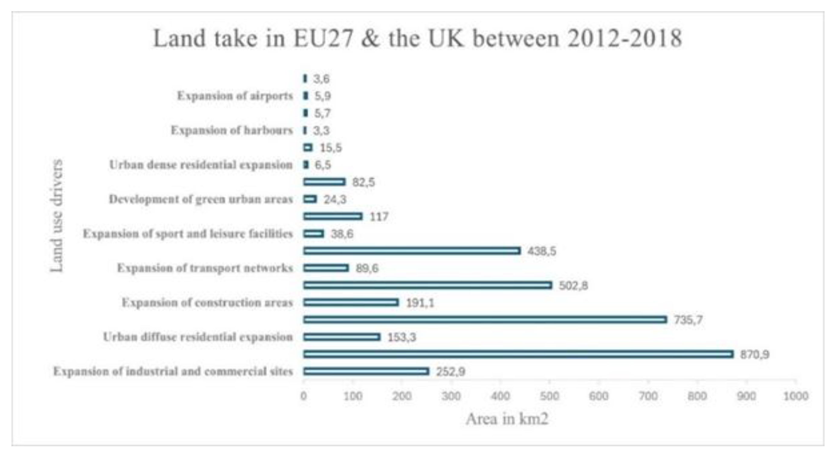

Table 1.
Missions and Targets of the EU for Soil Health.
| Source | Targets and Goals |
| EU, 2018/841- Land use and forestry regulation for 2021-20303 | The framework outlines the commitments required of Member States regarding the LULUCF sector, which are integral to meet the targets set forth by the Paris Agreement and the EU’s GHG emission reduction goals for the 2021-2030 period. It also specifies the guidelines for accounting emissions and removals related to LULUCF practices. |
| Regulation (EU) 2023/839- LULUCF Amendment4 | Amends Regulation 2018/841 and the Governance Regulation 2018/1999, widening scope, simplifying reporting/compliance, and setting updated Member-State LULUCF targets for 2030. |
| Biodiversity Strategy for 2030 (EC, 2020c)5 | Chapter 2.2: Commitment to Land Degradation Neutrality through Updating Soil and Built Environment Strategies and the Mission of Soil Health and Food under Horizon Europe. |
| Soil Strategy for 2030 (EC, 2021)6 | Chapter 2: Reach no net land take by 2050. MS should set their own national, regional, and local targets. |
| Mission for Soil Health and Food (EC, 2020d)7 |
Objective 3: No net soil sealing and increase the reuse of urban soils for urban development Target 3.1: Switch from 2,4% to no net soil sealing Target 3.2: Increase the current rate of soil reuse from 13% to 50%. |
| Roadmap to a resource-efficient Europe (EC, 2011)8 | Milestone 4.6: Achieve no net land take by 2050. |
| Eighth Environment Action Programme to 2030 (EC, 2020b)9 |
Objectives: Decoupling economic growth from resource use and environmental degradation, targeting a zero-pollution ambition for a toxin-free environment, including air, water and soil protection, preservation and restoration of biodiversity |
Table 2.
Examined countries legislative frameworks.
| Country | Law | Short Description |
| Greece | Law 4685/2020—Incorporation into Greek legislation of Directives 2018/844 and 2019/692 of the European Parliament, the Council, and other provisions.10 | Chapter 3 pertains to the administration of protected areas and includes various essential elements: the governing bodies of the National Policy Governance System for Protected Areas; the formation, objectives, and oversight of the Natural Environment and Climate Change Organisation, which is responsible for advancing sustainable development and addressing climate change. It encompasses the functions and obligations of Protected Areas Management Units, including the conservation of species and habitats, the assessment of management objectives, engagement in local fire prevention planning, public awareness initiatives regarding protected areas, and actions that support ecotourism initiatives. Chapter 4 deals with the classification of specific zones within a protected area, which includes zones designated for absolute nature protection, special usage categories, and activities such as agriculture, forestry, livestock, aquaculture, recreational and professional fishing, rural development land improvement projects, and extractive activities; as well as biodiversity protection areas, wildlife sanctuaries, and national parks, along with their specific characteristics. |
| Law 4447/2016—Spatial Planning, Sustainable Development, and Other Provisions.11 | Consisting of 56 articles and divided into two main parts, it is designed to delineate a framework for spatial and urban planning, focusing on sustainable development and environmental protection. Specifically, Part I pertains to land use and spatial planning, defining essential terms such as the spatial planning system and strategic spatial planning. It also addresses regulatory spatial planning, which governs land use in urban and rural contexts. The law encompasses the organization and structure of the spatial planning system, the national spatial strategy for sustainable development, the management of public assets, the implementation of land policy, as well as the creation of a national planning council and its associated responsibilities. | |
| Law 4759/2020—Modernization of Spatial and Urban Planning Legislation.12 | Law’s provisions/objectives are articulated as folows: The spatial and urban planning system is designed to be more efficient, expeditious, and improved, addressing existing ambiguities and conflicts. Specific provisions for maritime spatial planning are delineated, ensuring its separation from land spatial planning, particularly concerning coastal land areas. Regulations are established for development activities outside urban planning zones and within organized areas for productive endeavours. The law emphasizes the control and protection of the constructed environment. An electronic urban identity framework is introduced. Provisions address unauthorized constructions and land-use alterations to resolve challenges related to interpreting associated regulations. Law introduces measures for urban expropriation. It stipulates the appointment of certified evaluators for spatial reports, who will evaluate these documents to guide the development of spatial and urban plans. |
|
| Law 2742/199913 Spatial planning, sustainable development and other provisions. |
The law is designed to establish core principles and develop modern governance frameworks, processes, and land and spatial planning strategies that facilitate sustainable development. It aims to promote productive and social cohesion, protect the environment throughout the national territory, and enhance the nation’s position at the international and European levels. The law comprises six chapters and 29 articles outlining the necessary characteristics for National Frameworks of Spatial Planning, encompassing general and thematic aspects. | |
| Law 1650/1986, Article 1914 | This law serves as the foundation for environmental protection. Its core objectives include preventing pollution and environmental degradation, safeguarding human health, renewing natural resources, and rationally managing non-renewable or rare resources, considering existing and anticipated needs. It aims to protect soil, surface, subterranean waters, and the atmosphere while ensuring the conservation of nature and landscapes, particularly in regions of notable biological, ecological, aesthetic, or geomorphological significance. The law also regulates permissible waste emissions and mandates environmental impact assessments. It is essential to highlight that Law 1650/86 introduces a more extensive classification of protected areas than that currently defined by the Forestry Code. |
|
| Italy | Legge Urbanistica, 1942, n. 1150.15 |
The Law constituted one of the most advanced urban planning regulations of its time and continues to underpin the complex framework of Italian urban planning legislation. The proposed system was hierarchical, emphasizing strict urban and regional spatial development regulations and direct governmental action at the national level. This system was clearly defined and consisted of two principal planning types: an urban land-use plan and a regional strategic plan, known as the territorial coordination plan. The plans were associated with two principal institutions: the municipalities and the national government. |
| “Bridge Law” No.765, of 196716 and the Joint Ministerial Decrees of 196817 (both amendments of the Legge Urbanistica) |
Both instituted mandatory taxations to facilitate the provision of land for public use and developed standards for allocating public services and infrastructure in each land-use plan based on the expected demographic growth over the next ten years. | |
| Law No. 142 of 8 June 1990 “Ordinamento delle autonomie locali” | Established the fundamental framework for local government organization in Italy, emphasising decentralisation and administrative autonomy. The law defines roles, responsibilities, and governance structures for municipalities, provinces, and metropolitan cities. Part of its objectives is to promote administrative decentralization and local autonomy. Additionally, it provides the guidelines for territorial and urban planning, while facilitating inter-municipal and inter-institutional cooperation. Among its key provisions, it recognizes municipalities (Comuni) and provinces (Province) as autonomous administrative units, as well as establishing the role and functions of metropolitan cities. Furthermore, the law introduces tools for coordination between municipalities and higher-level planning authorities. |
|
| Title V (Titolo Quinto)18 (Modified by Constitutional Law n. 3/2001) |
Comprising 20 articles, the Law articulates in Article 17 the primacy of national legislative frameworks in four domains: environmental protection, cultural heritage, landscape conservation, and territorial governance, alongside infrastructure and urban planning. This article also empowers the regions with legislative autonomy concerning issues not expressly reserved for the State. | |
| Legislative Decree 22 January 2004, n. 42 Code of Cultural and landscape heritage (protection of landscape environment)19 | This Legislative Decree outlines Italy’s national code for protecting cultural and landscape heritage, which also encompasses environmental heritage. It proclaims the Italian Republic’s responsibility to defend cultural heritage and to support the conservation of the collective memory of its national community and territory, aligning with the broader objectives of cultural promotion and development. In Article 142, paragraph 1, sections c-g, protective measures apply to an array of natural landscapes, including but not limited to rivers, streams, waterways, mountains, glaciers, national and regional parks, and forested territories. | |
| Legislative Decree No. 152/2006 approving the Code on the Environment.20 | The Code is organized into six Parts. The first part, Part I (articles 1-3), defines the scope of the application and introduces general provisions applicable to all sectors covered by the Code. Part II (articles 4-52) focuses on defining and regulating the procedures related to Strategic Environmental Assessment (VAS), Environmental Impact Assessment (VIA), and Integrated Environmental Authorization (IPPC). Part III (articles 53-176) focuses on soil protection, particularly addressing desertification. It also focuses on protecting water resources from contamination and their management. The national territory is categorized into hydrographical districts, where basin plans will be implemented. Section IV (articles 177-266) addresses waste management and the remediation of polluted sites, outlining the organization of the Integrated Waste Management Service. The fifth Part (articles 267-298) focuses on air quality, striving to decrease atmospheric emissions. Finally, the sixth Part (articles 299-318) applies the precautionary principle and delineates the liability framework. | |
| France | SRU ‘La loi relative à la solidarité et au renouvellement urbain’, 200021 | SRU law aims to combat socio-spatial divides in urban settings by fostering greater solidarity and addressing urban sprawl by carefully densifying already urbanized areas. The law clarifies the provisions of the City Orientation Law (LOV) from 1992, particularly regarding the balance of social housing in urban locales. The SRU law further defines the potential role of the State within a refreshed vision of urban planning. Article 1 stipulates that the territorial coherence plan (SCOT) is a compulsory element for enhancing spatial planning in urban settings. The SRU law aims to improve subdivision quality by requiring operators to submit an architectural and landscape project with their applications for subdivision authorization. This project should incorporate elements related to environmental sustainability and waste management. Simultaneously, the SRU law also serves to ease the restrictions associated with marketing practices. |
| The ‘Grenelle I’ Law (2009)22 |
The Grenelle I framework delineates various objectives and targets pertinent to climate change and energy management, including: Buildings: Establish the building sector as the foremost ally in combating climate change. Enforce the ‘Low Consumption Building’ standard for all new developments starting at the end of 2012 to maintain primary energy consumption below 50 kWh/m²/year. Target a 38% reduction in energy usage in older buildings by 2020. Urban planning: Synchronize policy and planning documents, especially those relevant to urban agglomerations. Transport: By 2020, reduce GHG emissions by 20% and decrease the sector’s dependence on fossil fuels. Implement an eco-tax for heavy vehicles in 2011. Invest EUR 2.5 billion from the state budget by 2020 to improve urban public transport infrastructure. • Energy: Contribute to the ambitious goal of reducing GHG emissions, aiming for a minimum of 23% of the energy mix to come from renewable sources by 2020. |
|
| Law 2010-788, 2010, on National Commitment for the Environment, also called the “Grenelle II Law.”23 | The law validates and expands upon the sustainable development objectives outlined in France’s 2009 Grenelle I Law. However, it lacks any provisions for a carbon tax, as France has chosen to await the establishment of relevant EU regulations. The statute is structured into six fundamental titles. Title I, “Buildings and Urban Planning,” focuses on optimizing building energy utilisation. Title II, referred to as “Transport,” includes provisions designed to hasten the progress of public transportation infrastructure. The provisions of Title III, known as “Energy and Climate,” introduce initiatives focused on minimizing energy consumption and carbon emissions by including energy-CO2 performance metrics on product labels. Title IV, “Biodiversity,” addresses strategies to ensure the effective operation of ecosystems and restore high-quality ecological water standards. Title V, “Risks, Health, and Wastes,” presents measures to alleviate noise and artificial light disturbances. Title VI, entitled “Governance,” mandates that corporations include a segment in their annual reports detailing the social and environmental impacts of their operations, along with a declaration of their commitment to sustainable development. |
|
| Poland | Act on the protection of agricultural and forest land (1995)—(Ustawa o ochronie gruntów rolnych i leśnych)24. |
This legislative framework articulates essential principles for protecting agricultural and forest lands and recultivating and improving land quality. Agricultural lands are safeguarded through several strategies, including limiting their use for other purposes, preventing degradation and destruction, implementing recultivation efforts, and conserving peat areas and natural water bodies. Likewise, forest lands are protected through restrictions on their allocation for alternative uses, measures to prevent degradation and destruction, efforts to restore land value, and actions to maintain or enhance productivity. The statute is divided into the following sections: General provisions; Limitations on land allocation for purposes that are neither agricultural nor forestry-related; Exclusion of land from agricultural or forestry production; Initiatives aimed at preventing land degradation; Land recultivation and its subsequent use; Financial aspects related to the exclusion of agricultural land from production; Supervision of the implementation of the provisions outlined in this Act; and finally, Transitional and final provisions. |
| Act on planning and spatial development (2003) - (Ustawa z dnia 27 marca 2003 r. o planowaniu i zagospodarowaniu przestrzennym)25 |
The Act outlines the foundational principles that guide the formulation of spatial policy by local government entities and administrative bodies. It outlines the extent and methodologies employed in allocating land for designated purposes and establishing regulations governing their development. It emphasizes spatial order and sustainable development as the cornerstone of these initiatives. The Act is organized into seven distinct chapters containing 89 articles. The chapters are as follows: General Rules; Spatial Planning in the Commune; Spatial Planning at the voivodeship Level; National Spatial Planning; Functional Areas; The Location of Public Purpose Investments and the Determination of Development Conditions for Additional Investments; Spatial Data Sets; Amendments to current legal provisions; and Provisions for transition and finalization. | |
| National Spatial Development Concept (NSDC)-203026 | The National Spatial Development Concept 2030 (NSDC 2030) is a fundamental national strategic document that governs spatial planning management in Poland. Six interconnected objectives for national spatial development by 2030 have been defined to support the realisation of this strategic goal. The NSDC 2030 framework aspires to improve the productivity and sustainability of the agricultural sector. Its second objective is to bolster internal cohesion and ensure equitable territorial development across the country’s regions by enabling the entire population to partake in development processes through guaranteed access to quality employment and public services. The fourth objective is to develop spatial structures that promote the achievement and preservation of Poland’s high-quality natural environment and landscape. To meet developmental needs, securing access to high-quality water is vital. A balance will be maintained between water extraction and wastewater discharge within catchment units. Moreover, the management protocols for other resources, such as soils and strategic minerals, will be clearly defined to enable the efficient and timely resolution of conflicts related to land development and to oversee the management of other natural resources in the same geographical context. Objective five is dedicated to reinforcing the resilience of spatial structures against the impacts of natural disasters and energy security issues while promoting spatial arrangements that enhance national defence capabilities. The principal elements of this objective include strengthening protection measures against extreme natural and man-made disasters, addressing threats to energy security, and developing effective strategies to respond to these threats. |
|
| Ukraine | Law No. 962-IV “On land protection”27. | This statute lays down the legal, economic, and social foundations for safeguarding land. It intends to promote sustainable land management, soil restoration, and enhancement while preserving the soil’s ecological functions and protecting the environment. The core principles of land protection are as follows: (a) ensuring the protection of land as the main national wealth of the Ukrainian people; (b) prioritizing the environmental safety requirements in the use of land as a spatial basis, natural resources and primary means of production; (c) providing compensation for damages caused by breaches of national land protection regulations; (d) regulating and limiting the effects of economic activities on soil; (e) combining economic incentives with legal responsibilities in the domain of land protection; and (f) promoting public involvement and transparency in land protection processes. This legal framework comprises nine sections, each further divided into fifty-six articles. The initial section presents the general provisions. The second section articulates the powers of state authorities and local government bodies concerning land protection. The third section pertains to the supervisory functions relating to land protection. The fourth section outlines comprehensive measures for land protection. The fifth section establishes the state standards and regulations applicable to land protection. The sixth section discusses the role of economic activities in land protection. The seventh section addresses the funding mechanisms for land and soil protection initiatives. The eighth section outlines the liabilities for violating land protection laws. The ninth section concludes with the final provisions of the legislation. |
| Land Code (No. 2768-III of 2001)28. | The Law is organized into X Sections, which collectively contain 212 articles. Section I introduces the general provisions. Section II defines the composition and purpose of the Ukrainian land. Section III outlines the rights associated with land ownership. Section IV discusses the acquisition and exercise of these land rights. Section V provides guarantees for the protection of land rights. Section VI addresses the issue of land conservation. Section VII pertains to management practices related to land use and its protection. Section VIII outlines the liabilities for breaches of land legislation. Section IX contains the final provisions, and Section X outlines the transitional provisions. Article 182 of the Law delineates that land management aims to promote the rational utilization and safeguarding of soil, establish a conducive environment, and enhance natural landscapes. |
|
| Law No. 858-IV on land management29. | The existing law establishes the legal and organizational parameters for land management, targeting the regulation of relationships between state executive bodies, local self-governments, legal entities and individuals to ensure sustainable development of land use practice. This framework is designed to ensure the sustainable development of land use practices. The legal framework is divided into nine sections, encompassing seventy articles. Section one (articles 1-7) provides the general provisions. Section two (articles 8-19) defines the plenary powers of state executive authorities and local self-governments concerning land use planning. Section three (articles 20-41) focuses on organizing and regulating land management processes. Section four (articles 45-48) addresses the execution of land management at national and regional scales. Section five (articles 49-59) pertains to implementing land use planning at the local level. Section six (articles 60, 61-1, and 63) discusses the state and the self-government control of land management. Section seven (articles 65-67) covers the scientific basis, personnel training, and funding related to land management. Section eight (articles 68-70) outlines the liabilities for land management legislation breaches. The ninth section concludes with final provisions. |
Disclaimer/Publisher’s Note: The statements, opinions and data contained in all publications are solely those of the individual author(s) and contributor(s) and not of MDPI and/or the editor(s). MDPI and/or the editor(s) disclaim responsibility for any injury to people or property resulting from any ideas, methods, instructions or products referred to in the content. |
© 2025 by the authors. Licensee MDPI, Basel, Switzerland. This article is an open access article distributed under the terms and conditions of the Creative Commons Attribution (CC BY) license (http://creativecommons.org/licenses/by/4.0/).
Copyright: This open access article is published under a Creative Commons CC BY 4.0 license, which permit the free download, distribution, and reuse, provided that the author and preprint are cited in any reuse.


