Submitted:
14 March 2025
Posted:
17 March 2025
You are already at the latest version
Abstract
Wuhan is dotted with lakes, known as “ City with Hundreds of Lakes”, the development of the city is inseparable from the river and lake waters, the evolution of the lakes has been affecting the construction and layout of the city. Since the 20th century, the lake evolution in the main urban area of Wuhan is the most intense and the urban development is also the most rapid. Therefore, based on the precious high-precision historical maps of Wuhan in the early and mid-20th century, combined with the information of lakes in Wuhan obtained from satellite remote sensing images, the evolution characteristics of lakes in Wuhan in the past 100 years (1920~2019) were investigated through the theory of landscape fractal, and the response mechanism of lake evolution to urban expansion was further explored by combining with the trajectory of urban expansion. The results show that the area of lakes in Wuhan declined from 2,133.5 km2 in 1920 to 550.8 km2 in 2019, with a total decrease of 1,582.7 km2, an area shrinkage rate of 74.18 % , and a strong amplitude of area change. The changes of fractal dimension and shoreline development coefficient of lakes in Wuhan city show synchronization as a whole, with occasional fluctuations, but on the whole the fractal dimension and shoreline development coefficient of lakes are getting smaller in a century. Specifically, the evolution of lakes in the Hankou area is mainly affected by the construction of dykes and lake filling, and most of the lakes are resolved and fragmented under the influence of urban expansion, whereas the evolution of lakes in Wuchang and Hanyang is mainly caused by the urban construction around the lakes, and many lake branches are cut for various urban constructions, and the shape of the lake tends to be simple and regular under the influence of urban expansion. This study is of great significance to fill in the history of lake evolution in Wuhan before the popularization of remote sensing, and to guide the rational development of lakes in Wuhan and the sustainable and healthy development of Wuhan.
Keywords:
Wuhan City
; lake evolution
; historical maps
; remote sensing images
; urban expansion
1. Introduction
Lakes are an important national resource, as an important node in the interaction of the atmosphere, biosphere, lithosphere and terrestrial hydrosphere [1], the dynamic changes of lakes directly affect the regional ecological and environmental security and sustainable socio-economic development. The middle and lower Yangtze River plain and Tibetan plateau are the most concentrated areas for the distribution of lakes in China, forming two major dense lake clusters opposite to each other in the east and the west [2], among which the middle and lower Yangtze River plain is the most concentrated area of freshwater and shallow water lakes in China.
Wuhan is located in the middle and lower reaches of the Yangtze River, with a network of rivers and numerous lakes, and is known as the “River City” and “City with Hundreds of Lakes”. Lakes are one of the most important natural resources and ecological background elements in Wuhan [3]. With the rapid population growth and urban development, the number and area of lakes in Wuhan have decreased sharply, and the ecological problems are serious, which have seriously affected the sustainable development of the city [4,5]. The ecological environment [6,7,8,9,10,11] and scale changes [12,13,14,15,16,17,18,19] are hot issues that have been of interest to many geoscientists and environmental scholars in recent years.
Based on remote sensing data from 1990 to 2019, Wen analyzed the evolution characteristics of 58 lakes in Wuhan from 1990 to 2019 from three aspects: lake area, lake landscape and lakefront ecology, and found that the total area of 58 lakes decreased by 15.3%. The lake landscape showed a worsening trend, and all the five lake landscape indexes showed a decreasing trend. The remote sensing ecological index of lakeside area showed a gradual recovery trend [20]. Chen analyzed the changes of major lakes in Wuhan from a landscape perspective by using Landsat remote sensing imagery over a 40-year period from 1973 - 2013, and concluded that the evolution of lakes within the city, especially shallow-water lakes, is drastically affected by policy orientation and economic drive [21]. Shi analyzed the permanent disappearance and seasonal elongation of 28 major urban lakes in Wuhan by using the Landsat and HJ-1A long time-series remote sensing data from 1987 - 2016. 1A long time series remote sensing data to study the permanent disappearance and seasonal elongation of 28 major urban lakes in Wuhan, the results of which showed that most lakes in Wuhan have shrunk over 30 years, leading to a permanent shift from water to land [22]. Based on the theory of landscape ecology, Chen used Landsat image data of 1995, 2005 and 2015 to establish a landscape ecological security evaluation model of lake subsystems in Wuhan central city using multiple landscape indices, and concluded that the landscape ecological security of lake systems in Wuhan city has been deteriorating continuously and shows a tendency of spreading outward with the development of the city [23]. In terms of the most concerned lake evolution in Wuhan, most of the research periods have been concentrated since the 1970s and 1980s, i.e., after the widespread use of remote sensing image data. Although the research period has reached 40 - 50 a, it is obvious that the only time period is not enough to explain the lake evolution law in Wuhan, especially the relationship between urban development and lake evolution. In this regard, historical maps become an important supplement [24,25,26].
Through the collection of a large number of ancient maps, it is found that the earliest maps of Wuhan with scale completed by modern cartographic technology appeared in the early 20th century. In this paper, measured historical maps, historical data and high-precision remote sensing image data of Wuhan since the early 20th century are used as research materials, and geographic information technology is used to discuss the evolution process of Wuhan's lakes in the past 100 years, extending the evolution sequence of Wuhan's lakes to the centennial scale, and systematically analyzing the relationship between Wuhan's lake evolution and urban expansion.
2. Materials and Methods
2.1. Study Area
Wuhan is located in the middle reaches of the Yangtze River, in the eastern part of Hubei Province (29°58'-31°22' N and 113°41'-115°05' E), and the terrain is dominated by relatively flat hills and riverside plains below 50 m (Figure 1). The area is crisscrossed by rivers and dotted with lakes of various sizes, with 166 lakes above 0.1 km2; the Yangtze River, the third largest river in the world, and its largest tributary, the Hanjiang River, pass through the city, dividing the center of Wuhan into three, forming a pattern of three towns, namely, Wuchang, Hankou, and Hanyang [27].
The rivers and lakes in the Wuhan area are an interconnected "river and lake system", and the formation of lakes is mainly related to the geological processes of rivers, so the distribution pattern of lakes in Wuhan depends largely on the evolution of the Yangtze River, the Han River and other smaller rivers. According to the relationship between the formation of lake basins and riverine geologic processes, the lakes in Wuhan can be categorized into four types: river channel relic lake, riverbank breach lake, interfluvial depression lake, and valley barrier lake [28]. Valley barrier lake is the most numerous type of existing large lakes in Wuhan, and the most dominant type of lakes on both sides of the main stream of the middle and lower reaches of the Yangtze River.
2.2. Data Sources
The study mainly relies on high-precision historical maps of Wuhan and high-resolution Landsat series satellite remote sensing images. Regarding the selection of historical maps, three periods of 1:100,000 historical maps measured by modern cartographic techniques were selected, with high resolution and accuracy, and could accurately reflect the lake coverage information of Wuhan City in different periods (Table 1).
The Landsat series satellite remote sensing images provided by NASA were downloaded from the geospatial data cloud (http://www.gscloud.cn/), with a spatial resolution of 30 m. A total of three remote sensing images were downloaded from the same period of time with different orbital numbers (Table 2), with complete coverage of the whole territory of Wuhan City. Since the time zone of satellite data has a great influence on lake extraction, and the seasonal changes of lakes are more obvious, in order to minimize the differences caused by seasonal changes of lakes and ensure the comparability of the extraction results, the time period of the downloaded images is winter with less clouds.
2.3. Research Method
Image processing was mainly performed using Arcgis 10.6 and ENVI 5.3 (Figure 2). The extraction of lake information from historical maps consists of three main steps: pre-processing (establishment of map coordinate system, map geographic calibration), found of lake elements, and acquisition of lake attributes (contour, area, perimeter, etc.). The operation of remote sensing image processing includes remote sensing image preprocessing (including radiometric calibration, atmospheric calibration, geometric calibration, mosaic splicing and cropping, etc.), lake information extraction (obtaining NDMI grayscale image, binarization), obtaining lake vector map and lake attribute calculation.
The study of lake evolution mainly uses landscape fractal theory for lake characterization, including the shoreline development coefficient and the fractal dimension of the lake, and the relevant formulas are as follows:
(1) Shoreline development coefficient:
where SL is the length of the lake shoreline and A0 is the lake area. Shoreline development coefficient is an important index to indicate the morphological characteristics of lakes, which is used to reflect the complexity of the lake shoreline [29]. Generally speaking, the higher the value is, the more irregular the shoreline is, and the more tortuous and variable the shoreline is; on the contrary, the more regular and simpler the shoreline is. The lake shoreline development coefficient is widely used in the classification and evaluation system of different lakes.
(2) Lake fractal dimension:
where P is the perimeter and A is the area. Fractal dimension is an index reflecting the complexity of the lake landscape, which is mainly used to illustrate the intensity of the impact of human activities on the lake [30]. The theoretical value of fractal dimension is between 1 and 2, and the normal calculation results of fractal dimension of lakes are generally in the range of 1 to 1.5. Generally speaking, the larger the value is, the more irregular the shape of the lake is, the more complex the geometric form is, and the less the disturbance is; when the value is closer to 1, it reflects the simpler the geometric form of the lake is, and the more regular the shape is, which seems to be square, and the stronger the similarity of the lake is, and the lake is subjected to a larger disturbance.
3. Results and Discussion
3.1. Trajectory of Lake Change Over a Century
In this study, we took important lakes in the main urban areas of Wuhan (Wuchang area, Hankou area and Hanyang area) as the research object, combined with historical maps and remote sensing data to calculate the changes of lake size and quantity in the past 100 years. In order to test the consistency between these two types of data, the Donghu Lake, Nanhu Lake and Moshui Lake on the 1976 historical map were compared with the results of the remote sensing interpretation in 1973 (see Table 3 for accuracy evaluation).
The results show that the accuracy of the lake coverage area for the same period of time for both data sets is higher than 96 %, and the spatial consistency of the lake coverage between the images and the maps is higher than almost 80 %. This indicates that the lake data obtained from historical maps are accurate during the period when there were no satellite images.
In this study, we counted and estimated the area of lakes in the same range within the main urban area of Wuhan in 1920, 1976 and 2019. Figure 3 shows the changes in area and number of lakes in Wuhan over the past 100 years.
From Figure 3, it is found that the lake area in Wuhan is decreasing as a whole, and in the same study area, the lake area in Wuhan decreased from 2133.5 km2 in 1920 to 550.8 km2 in 2019, with a total decrease of 1,582.7 km2 in 100 years, with an area shrinkage rate of 74.18%, which is a strong change in the area. From the quantitative point of view: 48 lakes with more than 0.5 km2 in Wuhan in 1920, 30 lakes in Wuhan in 1976, and 41 lakes in Wuhan in the same study area as that of 1920 were extracted in 2019.
From the perspective of the three regions (Table 4), the lake shrinkage in Hankou region is the most significant, with a total decrease of 1013.1 km2, followed by Wuchang region, with an area decrease of 396.9 km2, and finally Hanyang region, with an area decrease of 172.7 km2; from the perspective of the different phases, Wuhan lakes in the period of 1920~1976 have shrunk significantly, with an area decrease of 1,477.6 km2, and the rate of area shrinkage is 69.25 %, and the rate of area change in 1976~2019 is slowing down significantly, with an area shrinkage rate of 16.02 %.
3.2. Changes in Lake's Characteristic Indices
In order to clearly show the evolutionary characteristics of lakes in Wuhan City during the century, firstly, using the fractal dimension of lake and the coefficient of shoreline development as the characteristic index of lake, the characteristics of lake in Wuhan city in the past hundred years were analyzed. It was concluded that the changes of fractal dimension and shoreline development coefficient of lakes in Wuhan city showed synchronization as a whole, with occasional fluctuations. The values of fractal dimension is concentrated between 1 and 1.4 (Figure 4), and the values of shoreline development coefficient is concentrated between 1 and 8 (Figure 5), and the numerical changes are repetitive, but the fractal dimension and shoreline development coefficient of the lakes in the past 100 years have been getting smaller, and the fractal dimension of the lakes is getting closer to 1, which indicates that the lakes are subjected to greater human interference, and the geometries of the lakes tend to be simpler.
Taking the changes of lake characteristic index of Donghu Lake as an example (Figure 6), it is divided into three stages to illustrate the evolution of lakes in Wuhan in different periods:
(1) Natural evolution stage: As shown in the Figure 4 and Figure 5, the lake characteristic indices in Wuhan are on the whole higher in 1920, and the shoreline development coefficient and fractal dimension of Donghu Lake were 4.727 and 1.164 (Figure 6a). The shape of Donghu Lake was mainly affected by natural environment and climate. It shows that the lake shoreline in Wuhan City at this time is naturalized as a whole, the lake branches are more complex, the lake is relatively less affected by human activities, and the natural properties of the lake are obvious.
(2) Factitious construction stage: In this stage, Wuhan's urban construction, including the construction of roads, infrastructure, bridges and the embryonic stage of real estate development, encroached on the lake to varying degrees. In 1973, the shoreline of the lake began to change significantly. Under the influence of human activities, the shape of the Donghu Lake became irregular and its fractal dimension was high (Figure 6b).
The shoreline development coefficient and fractal dimension of Donghu Lake are 6.656 and 1.205, respectively, which have significantly increased compared with the 1920 values. From the point of view of lake integrity, due to the increase of urban construction land, the lake branch of Donghu Lake has been extensively developed due to human activities. As is shown in the red circle in figure 6b, the branch on the north side of the Donghu Lake began to break up, the reason is that part of the water surface north of the Donghu Lake was divided due to urban construction, that is, today's Yangchun Lake. In addition, there are more large-scale industrial land on the east bank of the Donghu Lake, such as Wuhan Iron and Steel Company. The lake is gradually transformed into industrial land, and the lake becomes fragmented [31].
(3) Factitious control stage: By 2019, the shoreline development coefficient and fractal dimension of many lakes are low. At this time, the lake in Wuhan was significantly affected by human activities, and frequent human activities interfered with the natural form of the lake. With the expansion of the urban built-up area, a large number of lake branches were filled in, the lake branches were seriously cut, and the boundary of the lake became simple and regular, and the shape of the lake tended to be simplified. At this time, the shoreline development coefficient and fractal dimension of the Donghu Lake are 4.662 and 1.172, respectively, which are significantly lower than 1973. The red circle in the figure 6c shows that some branches on the north side of the Donghu Lake have disappeared in 2019.
At the same time, it can be seen from the interpretation of remote sensing satellite images in 2019 that the artificial solidification of the shoreline of the Dong Lake has reached 22 km, which is closely related to the construction of the Donghu Lake Scenic Area of Wuhan in this period. Due to the rapid expansion of Wuchang, Donghu Lake soon changed from "Suburban lake" to " Urban lake ", and Donghu Lake became a huge park for citizens to play. Since the reform and opening up, the area of the Donghu Lake scenic has been expanding, becoming the first batch of national key scenic spots and National AAAAA level tourist attractions in China, accompanied by the continuous solidification of the shoreline, the area of the lake is gradually stable, the current Donghu Lake native natural shoreline accounts for only 16%, artificial ecological shoreline is about 28%, and artificial hardened shoreline 56%. In 16 connecting channels with a total length of 43 km, the artificial hardening rate is about 88% [32].
3.3. Response of Lake Evolution to Urban Expansion
The evolution and exploitation of lakes in Wuhan over the past hundred years are closely related to its social development and urban construction process. It can be said that the history of Wuhan's urban development is equivalent to the history of lake demise. In the process of development, there is always a dynamic and reciprocal relationship between city and lake. Urban expansion, levee construction and change of land use will all affect the evolution of lake, and the evolution of lake in the main urban area of Wuhan is mainly influenced by the urban expansion. Therefore, this paper mainly discusses the mechanism of lake evolution based on the different ways of lake transformation by human beings in urban expansion.
Since the establishment of Wuhan City in the Republic of China, Wuhan City has entered the period of integrated development of the three towns. Due to the limited space along the river, the urban development of Wuhan began to move to the lake area of the plain and entered the stage of expansion around the lake, and the ecological environment of the lake began to be frequently disturbed by human activities. The two fastest periods of urban expansion in Wuhan are from 1949 to 1966 and since 1982, which are also the climax of the expansion of the city around the lake, and Wuhan entered the stage of conquering nature for development [3]. Due to the different geological environments and different types of lakes in the three towns of Wuhan, there are differences in the way of expansion around the lake. The influence of urban expansion on lake evolution in Wuhan mainly consists of three modes: dike construction, lake filling and development around lake.
3.3.1. Hankou Area: Dike-Draining-Land
Hankou area is located in the interfluvial depression among the Yangtze River, the Han River and the Fu River, with a dense network of lakes and rivers, which was originally a small piece of land in water overgrown with water and grass before the Ming Dynasty, and was under the jurisdiction of Hanyang County. In the early period, Hankou developed mainly along the natural dykes along the north bank of the Han River and Yangtze River, and the construction of dykes led to the development of Hankou from the natural dykes to the plains, and thus the construction of dykes played a crucial role in the development of the Hankou area [33].
Due to the rapid development of Hankou in the late Qing Dynasty, the contradiction of insufficient urban space was most prominent, and the expansion around the lake bore the brunt of it. Hankou area belongs to the original Han River delta, with low terrain and lakes all over. Most of these lakes belong to the interfluvial depression lake, such as West Lake and East Lake, etc. are formed in the lowland between the Han River and the Fuhe River; Hou lake, Xiaoxiang Lake, etc. are formed between the Yangtze River and the Fu River. These lakes are large in size, with a wide and shallow basin, in the shape of a disk; the water is shallow, generally 1~2 m. The main way of expansion around the lake is “Dike-Draining-Land”. The two rapid expansions of Hankou city since the late Qing Dynasty, one is the construction of Zhang Gong dike and the demise of Hou Lake; the other is the construction of East-West Lake dike and the disappearance of West Lake and East Lake. These areas are now the main urban areas of Hankou (Figure 7).
The Zhang Gong Dike became a major barrier against the floods from the west and north of Hankou in Modern China, which greatly reduced the frequent flooding of the Houhu lake in Hankou, and Hankou was not flooded frequently. Zhang Gong Dike, like a huge arm spreading around, encircled a large area of land and water both inside and outside of Hankou, the natural waters and water systems that were originally linked together were cut off by the Zhang Gong Dike, and a large area of land in and outside of Hankou naturally appeared, and the natural siltation and elevation increase of some areas led to the natural expansion of the land [34]. After the construction of Zhang Gong Dike, land filling activities began in the Hankou area, more than 100,000 acres of low-lying land in Houhu Lake, which is the former channel of the Xianghe River, has risen to become land, and the urban area has expanded by seven times, which has created extremely important conditions for the development of Hankou [35].
The construction of the Dong Xihu Dike set a new starting point for Hankou's urban construction. The Dong Xihu Dike turned a 451 km2 area of low-lying terrain, surrounded by water on three sides, flooded frequently, and overgrown with reeds and lake grass into rich land with good fields, pastures, and fish ponds [36]. Large-scale reclamation has become an important reason for the significant shrinkage of the lake area in Hankou area, the West Lake in Hankou area disappeared, the East Lake shrank into a number of small lakes, there are still preserved Jinyinhu lake, Dugonghu lake, Huangshihai lake and other lakes of a very small scale.
3.3.2. Wuchang and Hanyang Areas: Development Around the Lake
Most of the lakes in Wuchang and Hanyang area belong to valley barrier lake on the denudation low terrain. These lakes are characterized by curved shores, dendritic branching, and depths of 2 to 4 m. The curved bays are interspersed with headlands or spouts. The development coefficient of the lake shoreline reaches 5-7 [3]. Since the centers of these lakes are relatively deep, the development of lake branches is relatively shallow. The main way of expansion around the lake is to block the branch and lakeshore around the lake. Since the Reform and opening up, some larger lakes have become urban lake.
From 1966 to 1996, the development around the lake in Wuchang area was mainly in the north of She Hill to Yujia Hill line, and Shahu lake had become urban lake by the 1980s. After that, the scope of urban expansion began to shift to the perimeter of Dong Lake, which had become urban lake by the end of the last century. After 1996, the most significant changes in the urban development of the Wuchang area took place in the area south of She Hill to Yujia Hill line. For example, by 2000, Nan Lake had been partially occupied and divided into two lakes in the east and west due to the construction of roads and residential areas, and the natural lake branch in the lakeshore area has been hardened filled. And then by 2009, the whole South Lake lakeshore area was encroached by densely-packed buildings, and the West Lake surface of the Nan Lake, which had already been divided, was again encroached, with the form of a square [37].
In 1966, the inland boundary of the city was limited to the triangle area sandwiched between the Yangtze River and Han River. 1982 saw the beginning of the lakeshore development stage, and the speed of development in Hanyang accelerated. By 1996, the pattern of development around the lake around the Moshui Lake in the northern part of Hanyang had basically been formed, and gradually developed into urban lake. After 1996, the development around the lake was in full swing, and a series of lakes such as the Sanjiao Lake, the Beitaizi Lake, the Nantaizi Lake, the Tang Lake, and the Wanjia Lake in the southern part of Hanyang also became urban lake successively.
To summarize, the relationship between urban and lake in Wuhan in general has undergone a transformation from “City surrounded by lake” to “lake surrounded by city”. The urban expansion has caused the demise of lakes and the disappearance of branches of lake in different ways, and the values of lake characteristic indexes, such as the shoreline development coefficient and the lake fractal dimension, have become lower, resulting in the characteristics of the lake shoreline homogenization, the simplicity of the morphology, and the low degree of correlation between the rivers and the lakes. In the future, the development and utilization of lakes in Wuhan should still be carried out in accordance with the principle of sustainable development of the lake environment, based on the geographic location and natural attributes of different lakes, combined with the needs of urban development in the lake area, and the development and utilization and the management and protection of the lake area in an orderly manner.
4. Conclusions
Based on the high-precision historical maps and modern remote sensing image data of Wuhan city, this study used geographic information technology to reconstruct the evolution process of lakes in Wuhan City in the last hundred years from the early 20th century to 2019. It was found that from 1920 to 2019, the lake area in Wuhan City decreased by 1582.7 km2 in total, with an area shrinkage rate of 74.18 %, and the geometrical form of the lakes tended to be simpler and more regular. The evolution of lakes in the Hankou area is mainly affected by the construction of dykes and lake filling, and most of the lakes are resolved and fragmented under the influence of urban expansion, whereas the evolution of lakes in Wuchang and Hanyang is mainly caused by the urban construction around the lakes, and many lake branches are cut for various urban constructions, and the shape of the lake tends to be simple and regular under the influence of urban expansion. This study is of great significance to fill in the history of lake evolution in Wuhan before the popularization of remote sensing, and to guide the rational development of lakes in Wuhan and the sustainable and healthy development of Wuhan.
Author Contributions
Conceptualization, Chang'an Li; Data curation, Guoqing Li; Formal analysis, Guoqing Li; Funding acquisition, Yufen Zhang and Chang'an Li; Investigation, Guoqing Li; Methodology, Guoqing Li; Project administration, Chang'an Li; Resources, Chang'an Li; Software, Guoqing Li; Supervision, Yufen Zhang; Validation, Yufen Zhang; Visualization, Yufen Zhang; Writing – original draft, Guoqing Li; Writing – review & editing, Chang'an Li.
Funding
This work was supported by the National Natural Science Foundation of China (Grant No. 41871019 and 41672355) and provincial projects of Hubei: "Wuhan Multi-factor Urban Geological Survey Demonstration Project" (Grant No. WHDYS-2018-007).
Data Availability Statement
Data is available upon request.
Conflicts of Interest
The authors declare that they have no known competing financial interests or personal relationships that could have appeared to influence the work reported in this paper.
References
- Lu, A.; Yao, T.; Wang, L.; Liu, S.; Guo, Z. Study on the Fluctuations of Typical Glaciers and Lakes in the Tibetan Plateau Using Remote Sensing. Journal of Glaciology and Geocryology 2005, 27, 783–792. [Google Scholar] [CrossRef]
- Ma, R.; Yang, G.; Duan, H.; Jiang, J.; Wang, S.; Feng, X.; Li, A.; Kong, F.; Xue, B.; Wu, J.; Li, S. China's Lakes at Present: Number, Area and Spatial Distribution. Sci. China Earth Sci. 2011, 54, 283–289. [Google Scholar] [CrossRef]
- Li, C.; Zhang, Y. The Formation and Development of Wuhan City and the Evolution of Man-land Relationship. Acta Geologica Sinica 2021, 95, 940–942. [Google Scholar] [CrossRef]
- Cai, S.; Du, Y. The Characteristics of Lake Resources and It’s Development and Protection on the Jianghan Lakes Region. Journal of Central China Normal University (Nat. Sci.) 2000, 34, 476–481. [Google Scholar] [CrossRef]
- Yin, H.; Liu, G.; Pi, J.; Chen, G.; Li, C. On the River-lake Relationship of the Middle Yangtze Reaches. Geomorphology 2007, 85, 197–207. [Google Scholar] [CrossRef]
- Duan, X.; Hu, S.; Yang, T. Vertical Variation of Heavy Metals and It’s Magnetic Reponse Property and Environmental Significance in Core Sediment from Lake TangXun, WuHan, China. Quaternary Sciences 2007, 27, 1105–1112. [Google Scholar] [CrossRef]
- Gu, Y.; Li, X.; Qiu, H.; Huang, J.; Xie, S.; Ruan, X.; Zhou, X. Sediments Records of Eutrophication History in the Donghu Lake, Wuhan, over the Past 100 years. Ecology and Environment 2008, 17, 35–40. [Google Scholar] [CrossRef]
- Gu, Y.; Qiu, H.; Xie, S.; Huang, J.; Zhou, X. Lake Sediment Records for Eutrophication History in Response to Human Activity during Recent Century in the Liangzi Lake, Hubei Province. Earth Science—Journal of China University of Geosciences 2008, 33, 679–686. [Google Scholar] [CrossRef]
- Wang, X.; Ning, L.; Yu, J.; Xiao, R.; Li, T. Changes of Urban Wetland Landscape Pattern and Impacts of Urbanization on Wetland in Wuhan City. Chinese Geographical Science 2008, 18, 47–53. [Google Scholar] [CrossRef]
- Dong, J.; Qiao, S.; Xie, S. Distribution Model and Geochemical Characteristics of the Elements in the Surface Sediments of Liangzi Lake. Geological Science and Technology Information 2010, 29, 91–96. [Google Scholar] [CrossRef]
- Zhang, Q.; Dong, X.; Yang, X. Environmental Evolution of Lake Liangzi and Its Driving Factors over the Past 100 years, Hubei Province. J. Lake Sci. 2016, 28, 545–553. [Google Scholar] [CrossRef]
- Huang, P.; Liu, Y.; Liu, C.; Jiang, Q. Study on Evolution of Urban Lakes in Wuhan Based on RS/GIS. Ecology and Environmental Sciences 2012, 21, 1588–1593. [Google Scholar] [CrossRef]
- Zeng, Z.; Lu, X. Spatial-temporal evolution of urban lakes in Wuhan City based on remote sensing images. J. Lake Sci 2008, 20, 648–654. [Google Scholar] [CrossRef]
- Xu, K.; Kong, C.; Liu, G.; Wu, C.; Deng, H.; Zhang, Y.; Zhuang, Q. Changes of urban wetlands in Wuhan, China, from 1987 to 2005. Progress in Physical Geography 2010, 34, 207–220. [Google Scholar] [CrossRef]
- Zhang, Z.; Tan, S.; Zhou, M. Spatial Pattern, Openness and Spatial Distribution Characteristics of Lakes in Wuhan Central Urban Area. Sci. Sin. Tech. 2014, 44, 631–642. [Google Scholar] [CrossRef]
- Chen, K.; Wang, X.; Li, D.; Li, Z. Driving Force of the Morphological Change of the Urban Lake Ecosystem: A Case Study of Wuhan, 1990–2013. Ecological Modelling 2015, 318, 204–209. [Google Scholar] [CrossRef]
- Yang, K.; Duan, G.; Niu, R.; Huang, S.; Cao, Y. Analysis of Lake Changes in Wuhan Based on Multi-source Remote Sensing Data. Journal of Yangtze River Scientific Research Institute 2016, 33, 139–142+146. [Google Scholar] [CrossRef]
- Ma, J.; Huang, S.; Xu, Z. Dynamic Monitoring and Analysis of Lake Water Area in Wuhan City from 1973 to 2015 Based on Remote Sensing. Journal of Hydaulic Engineering 2017, 48, 903–913. [Google Scholar] [CrossRef]
- Pei, L.; Yan, D.; Zhang, H.; Wang, J.; Xu, K. Research on Evolution Characteristics and Causes of Urban Lakes in Wuhan from 1960s. Geology and Mineral Resources of South China 2018, 34, 78–86. [Google Scholar] [CrossRef]
- Wen, C.; Zhan, Q.; Zhan, D.; Zhao, H.; Yang, C. Spatiotemporal Evolution of Lakes under Rapid Urbanization: A Case Study in Wuhan, China. Water 2021, 13, 1171. [Google Scholar] [CrossRef]
- Chen, H.; Shi, T.; Wu, G. The Dynamic Analysis of Lake Landscape of Wuhan City in Recent 40 years. J. Lake Sci. 2015, 27, 745–754. [Google Scholar] [CrossRef]
- Shi, L.; Ling, F.; Giles, M.F.; Chen, C.; Fang, S.; Li, X.; Zhang, Y.; Du, Y. Permanent Disappearance and Seasonal Fluctuation of Urban Lake Area in Wuhan, China Monitored with Long Time Series Remotely Sensed Images from 1987 to 2016. International Journal of Remote Sensing 2019, 40, 8484–8505. [Google Scholar] [CrossRef]
- Chen, K.; Qi, M.; Wang, X.; Huang, G. Study of Urban Lake Landscape Ecological Security Pattern Evolution in Wuhan, 1995-2015. Acta Ecologica Sinica 2019, 39, 1725–1734. [Google Scholar] [CrossRef]
- Akbar, T.A.; Hassan, Q.K.; Ishaq, S.; Batool, M.; Butt, H.J.; Jabbar, H. Investigative Spatial Distribution and Modelling of Existing and Future Urban Land Changes and Its Impact on Urbanization and Economy. Remote Sening 2019, 11, 105–120. [Google Scholar] [CrossRef]
- Zlinszky, A.; Timár, G. Historic Maps as A Data Source for Socio-hydrology: A Case Study of the Lake Balaton Wetland System, Hungary. Hydrol. Earth Syst. Sci. 2013, 17, 4589–4606. [Google Scholar] [CrossRef]
- Zhang, Y.; Kong, X.; Deng, H.; Kong, C.; Li, W. Change Characteristic of Lakes in Hubei Province in the Past 100 Years. Wetland Science 2010, 8, 15–20. [Google Scholar] [CrossRef]
- Xie, Q.; Liu, J. Spatio-temoporal Dynamics of Lake Distribution and Their Impact on Ecosystem Service Values in Wuhan Urbanized Area during 1987-2016. Acta Ecologica Sinica 2020, 40, 7840–7850. [Google Scholar] [CrossRef]
- Li, C.; Zhang, Y.; Li, G. Genetic Classification of Lakes in Wuhan Based on River and Lake Geological Process. Earth Science 2022, 47, 577–588. [Google Scholar] [CrossRef]
- Kent, C.; Wong, J. An Index of Littoral Zone Complexity and Its Measurement. Can. J. Fish. Aquat. Sci. 1982, 39, 847–853. [Google Scholar] [CrossRef]
- Pan, W.; Li, D.; Tang, T.; Cai, Q. The Fractal Character of Lake Shoreline and Its Ecological Implication. Acta Ecologica Sinica 2003, 23, 2728–2735. [Google Scholar] [CrossRef]
- Wu, J. An Empirical Study of Wuhan Lakefront Landscape Change. Doctoral dissertation, Huazhong University of Science and Technology, Wuhan, China, 2010. [Google Scholar]
- Li, C.; Zhang, Y.; Li, G.; Guo, R.; Chen, Y. Formation of Dong Lake, Wuhan, China. Earth Science 2021, 46, 4562–4572. [Google Scholar] [CrossRef]
- Li, G.; Zhang, Y.; Li, C. The History of Embankment and Urban Development in Wuhan City during the Evolution of the Geological Environment of Rivers and Lakes. Geological Review 2021, 67, 1497–1506. [Google Scholar] [CrossRef]
- Fang, Q. On the Influence of Hankou Dike Construction on the Change of Urban Environment in Late Qing Dynasty. Jianghan Tribune 2009, 8, 72–78. [Google Scholar] [CrossRef]
- Pi, M. Brief History of Wuhan; Wuhan Press: Wuhan, China, 2005; pp. 177–182. [Google Scholar]
- Jia, Z. Unforgettable East West Lake Reclamation Project. Literature and History of Wuhan 2012, 1, 27–30. [Google Scholar]
- Wu, J. Quantitative Analysis of the Evolution of Wuhan's Lakeside Landscape and Land Use. Chinese Landscape Architecture 2013, 29, 124–127. [Google Scholar]
Figure 1.
Topography of Wuhan.
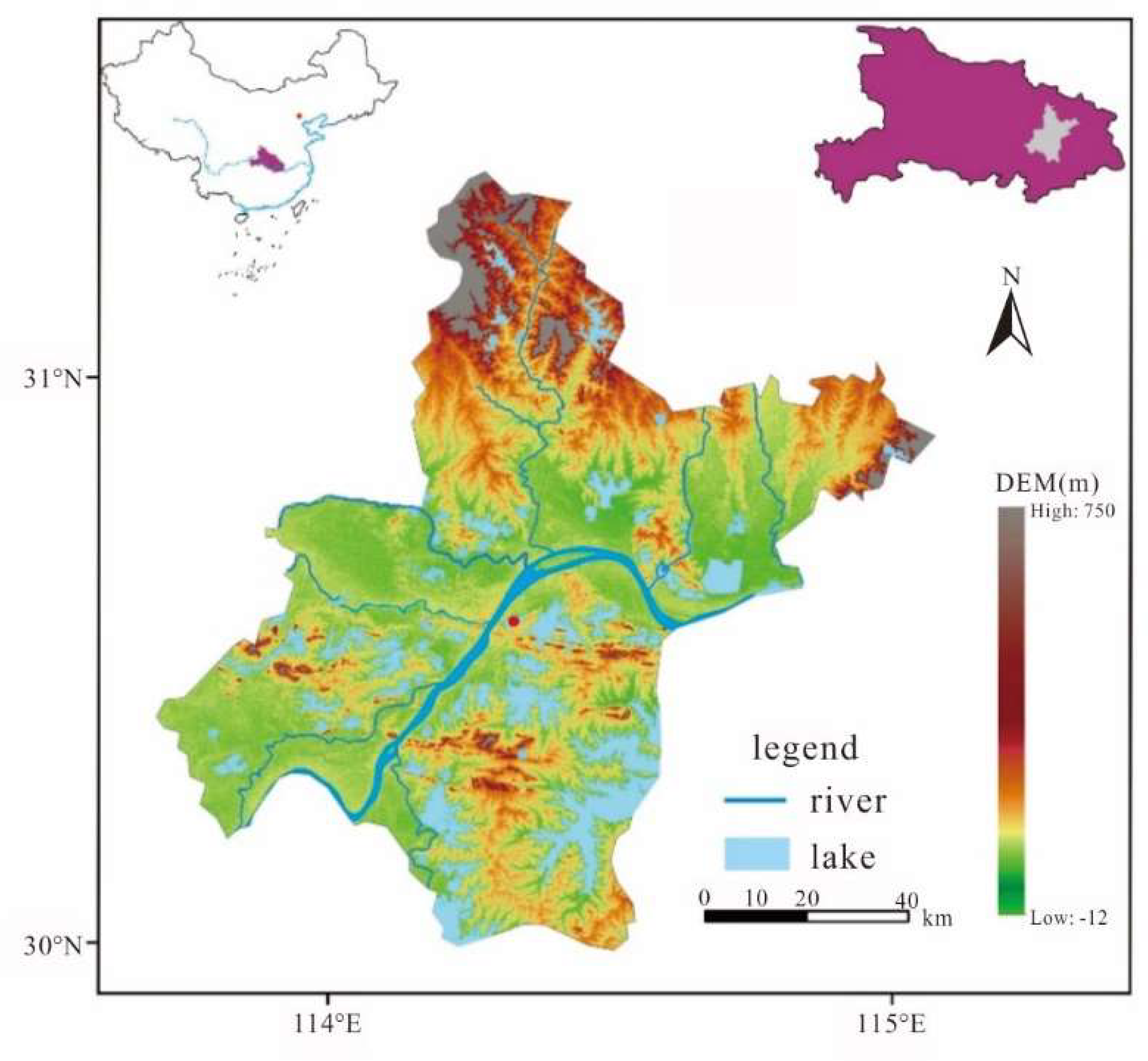
Figure 2.
Flowchart of image processing.
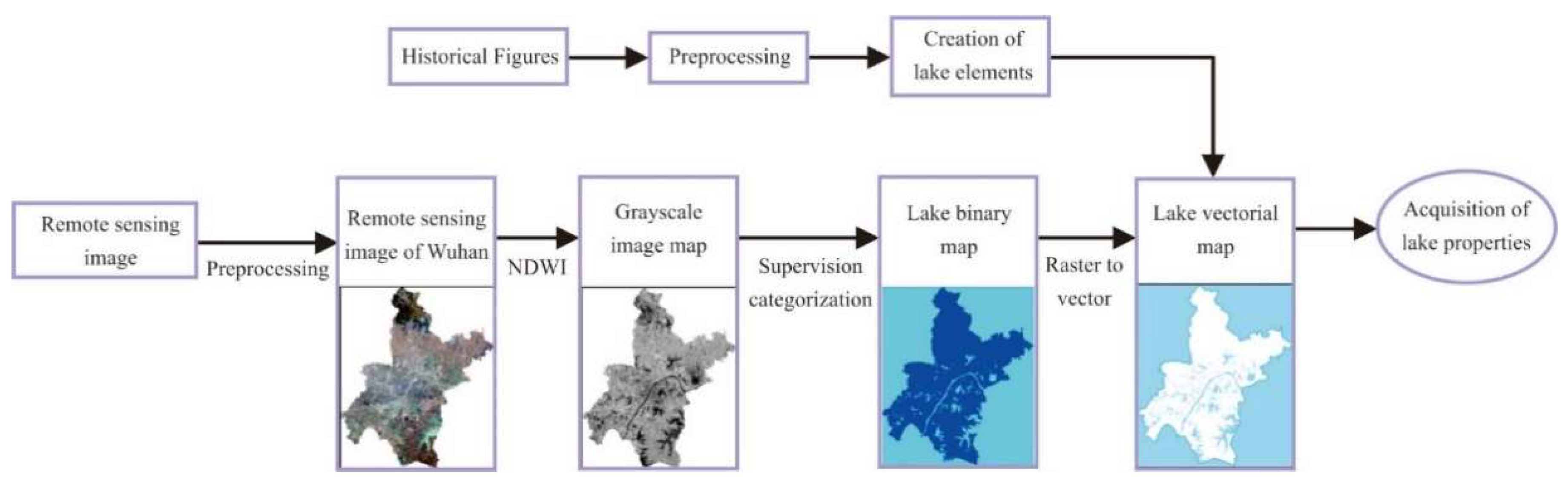
Figure 3.
The changes in the area and number of lakes within the main urban area of Wuhan over the past 100 years.
Figure 3.
The changes in the area and number of lakes within the main urban area of Wuhan over the past 100 years.
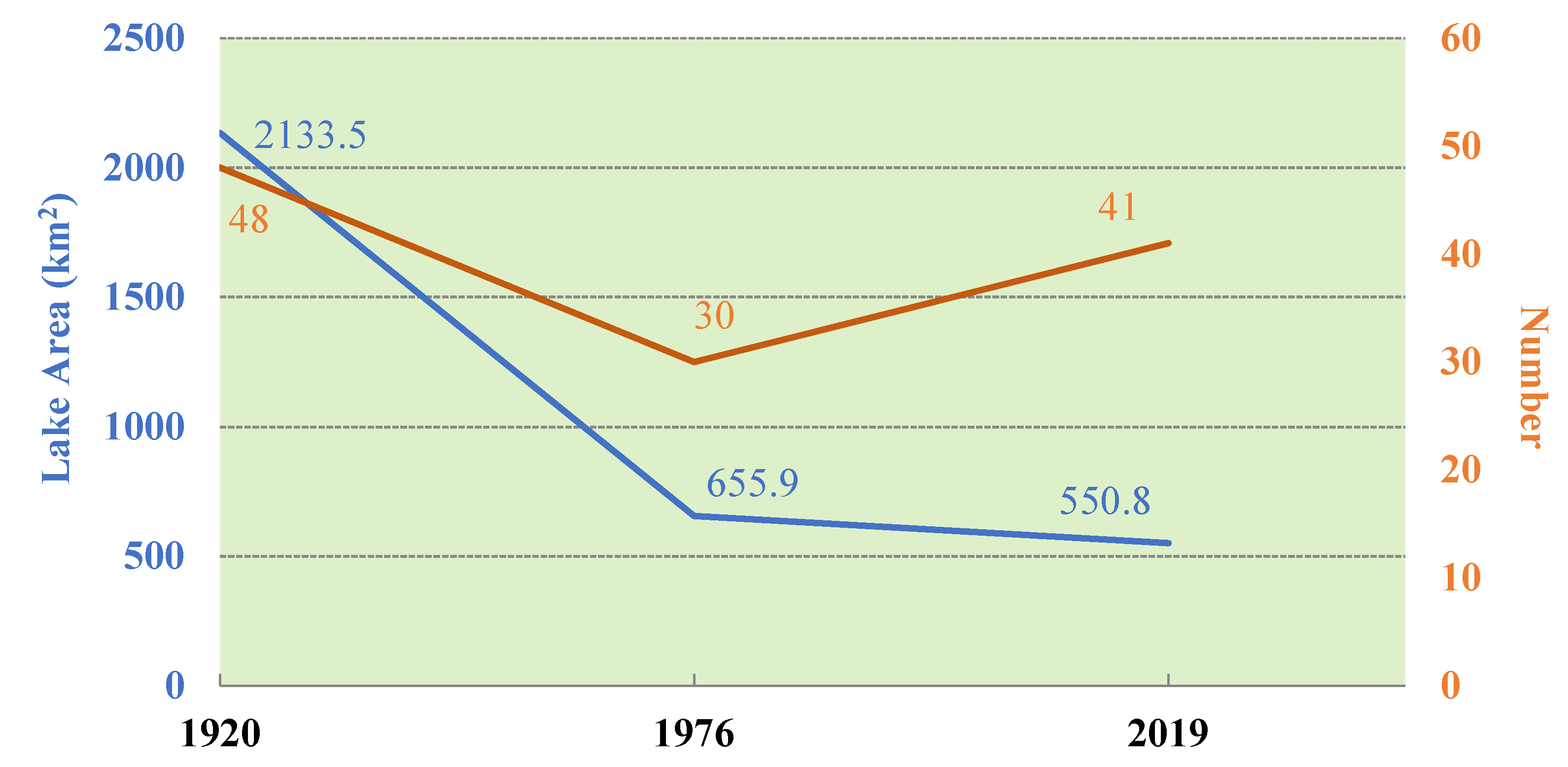
Figure 4.
Changes in lake fractal dimension in Wuhan.
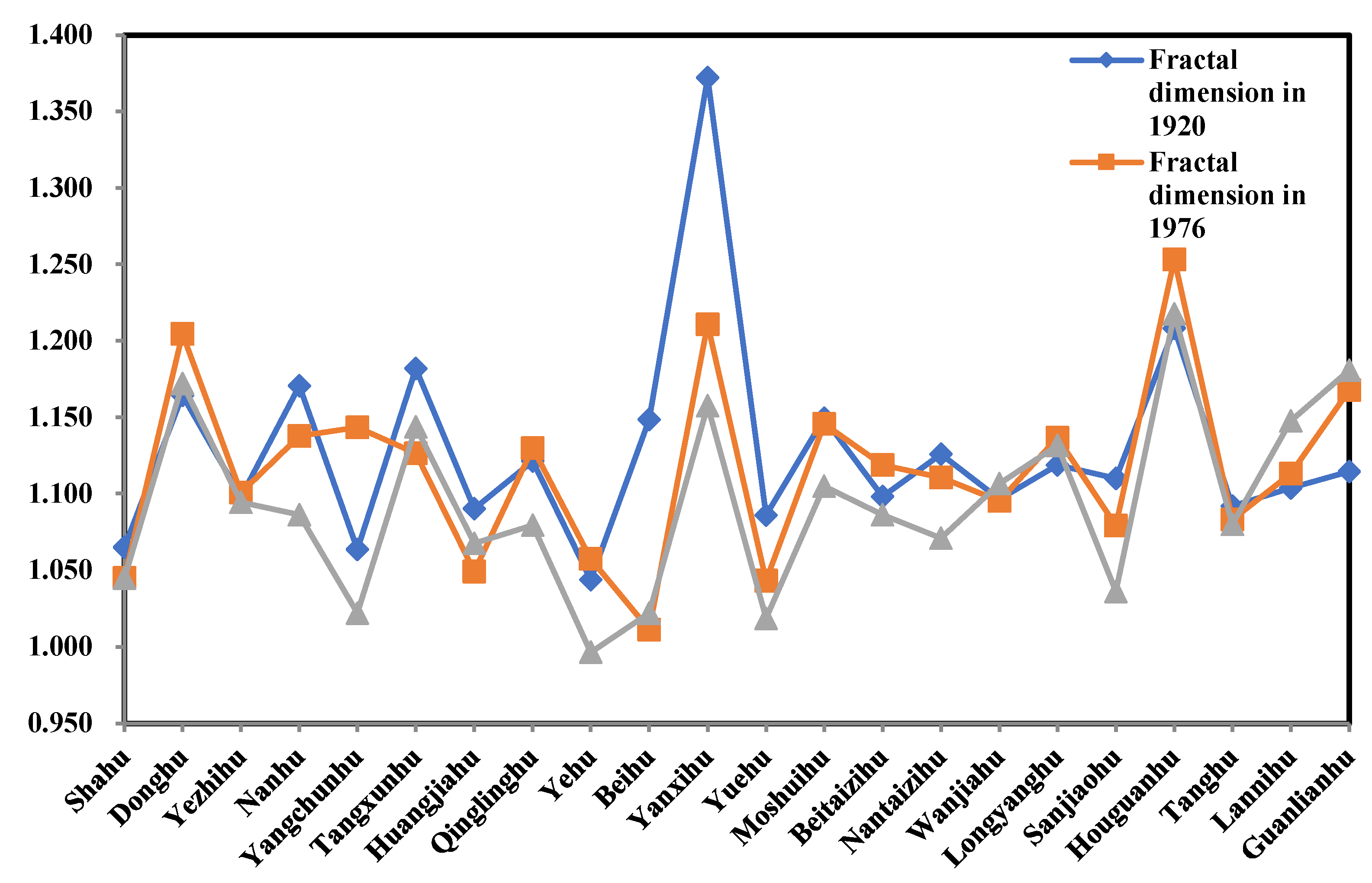
Figure 5.
Changes in lake’s shoreline development coefficient in Wuhan.
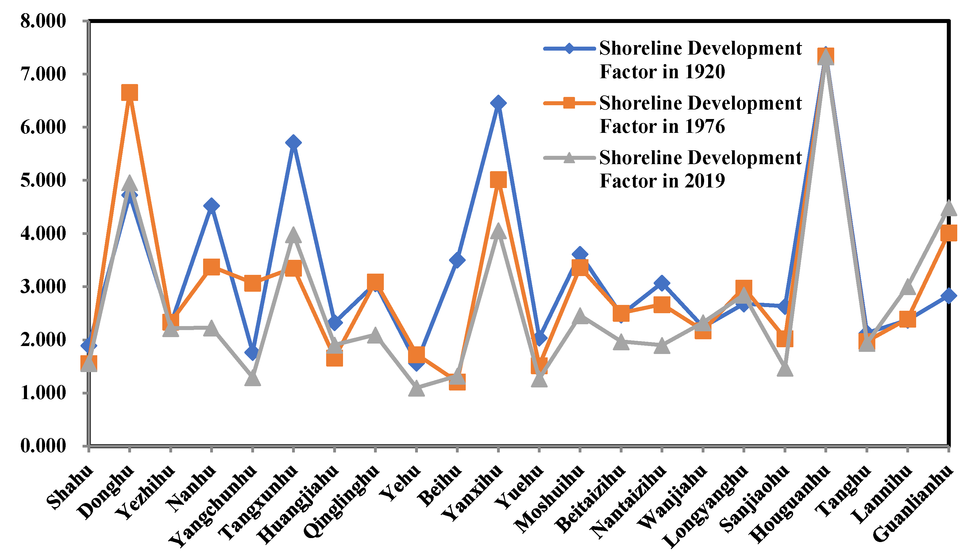
Figure 6.
Changes of Donghu Lake shoreline contours in different periods (a: The year 1920; b: The year 1973; c: The year 2019).
Figure 6.
Changes of Donghu Lake shoreline contours in different periods (a: The year 1920; b: The year 1973; c: The year 2019).
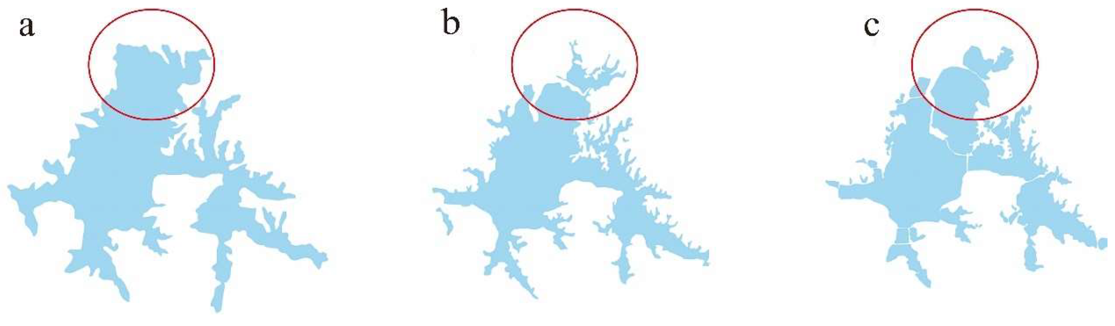
Figure 7.
Zhang Gong Dike and Dongxihu Dike in Hankou Area (According to 33).
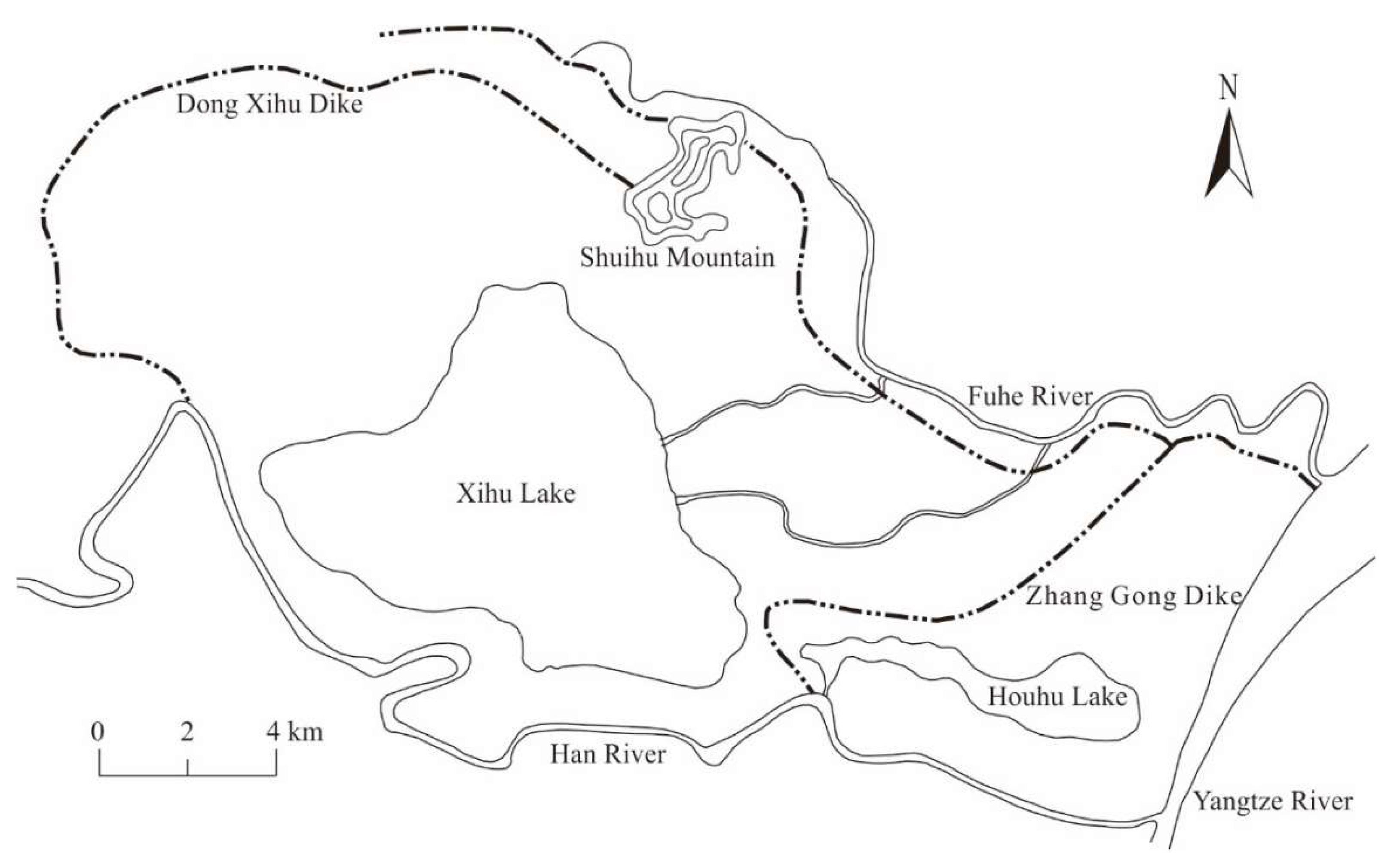

Table 1.
Table of details of historical maps.
| Name of Map | Year of Cartography | Scale | Cartographic Unit |
|---|---|---|---|
| Topographic map of the core area of Wuhan | 1920 | 1:100,000 | Hubei Army Survey Bureau |
| Map of Wuhan city | 1952 | 1:100,000 | Construction Bureau of Wuhan Municipal People's Government |
| Map of Wuhan city | 1973 | 1:100,000 | Surveying and Mapping Bureau of the General Staff Department of the Chinese People's Liberation Army |
Table 2.
Table of details of remote sensing images.
| Year | Sensor | Acquisition Time | Orbit Number |
|---|---|---|---|
| 2000 | Landsat 5 TM | 2000.12.08 2000.10.31 2000.10.31 |
123-38 123-39 122-39 |
| 2019 | Landsat 8 OLI | 2019.11.14 2019.12.07 2019.1.21 |
122-39 123-39 123-38 |
Table 3.
The accuracy evaluation of lake extraction results from historical maps.
| Typical Lakes | Lake Area of the 1976 Historical Maps Data A (km2) | Lake Area of the 1973 Remote Sensing Data B (km2) | Area Consistency Accuracy A/B(%) | Overlapped Spatial Area C (km2) | Spatial Consistency Accuracy C/B(%) | Commission Error of Historical Maps Area/Rate(A-C)/A(%) | Omission Error of Historical Maps Area/Rate (B-C)/A(%) |
|---|---|---|---|---|---|---|---|
| Moshui Lake | 3.75 | 3.9 | 96.15% | 2.92 | 74.87% | 22.13% | 26.13% |
| Nanhu Lake | 9.92 | 10.75 | 92.28% | 8.41 | 78.23% | 15.22% | 23.59% |
| Donghu Lake | 34.24 | 33.57 | 102.00% | 28.36 | 84.48% | 17.17% | 15.22% |
| Total | 47.91 | 48.22 | 96.81% | 39.69 | 79.19% | 18.18% | 21.65% |
Table 4.
The changes of lake area in three different areas of Wuhan City over the past 100 years (km2).
Table 4.
The changes of lake area in three different areas of Wuhan City over the past 100 years (km2).
| Year | Wuchang | Hanyang | Hankou | Total |
|---|---|---|---|---|
| 1920 | 808.1 | 245.5 | 1079.9 | 2133.5 |
| 1976 | 499.1 | 76.9 | 90.4 | 655.9 |
| 2019 | 411.2 | 72.8 | 66.8 | 550.8 |
Disclaimer/Publisher’s Note: The statements, opinions and data contained in all publications are solely those of the individual author(s) and contributor(s) and not of MDPI and/or the editor(s). MDPI and/or the editor(s) disclaim responsibility for any injury to people or property resulting from any ideas, methods, instructions or products referred to in the content. |
© 2025 by the authors. Licensee MDPI, Basel, Switzerland. This article is an open access article distributed under the terms and conditions of the Creative Commons Attribution (CC BY) license (http://creativecommons.org/licenses/by/4.0/).
Copyright: This open access article is published under a Creative Commons CC BY 4.0 license, which permit the free download, distribution, and reuse, provided that the author and preprint are cited in any reuse.


