

Submitted:
11 December 2024
Posted:
12 December 2024
You are already at the latest version
Abstract
In recent decades, there has been a significant transformation in global forests, characterized by widespread changes and disruptions, particularly in primary forest areas. The Isangi Territory in “the Democratic Republic of Congo” is one such deforestation hotspot, experiencing rapid forest disturbances. Various studies and government organizations have implemented systems that utilize satellite imagery to provide regular alerts on forest disturbances. However, the effectiveness of optical-based near-real-time monitoring methods is hindered by cloud cover in the humid tropics. To overcome these limitations, satellite missions that revisit an area more frequently have a higher chance of acquiring cloud-free images. The Sentinel-2 satellites presents a valuable opportunity for comprehensive global forest monitoring due to their high spatial resolution of 10 m and the frequent revisit time of 5 days. This study employs a maximum likelihood classification algorithm to map deforestation using Sentinel-2 satellite images from 2017 and 2022. The analysis is conducted at a spatial resolution of 10 meters, which enables enhanced disturbance detection in the tropical forest. The findings facilitate rapid change detection of forest disturbances, such as agricultural expansion and selective logging, within the study area. Sentinel-2 is hence a suitable source of satellite data for monitoring forest degradation in addition to deforestation.
Keywords:
forest disturbances
; forest degradation
; deforestation
; Isangi
; Congo
; rainforest
; Sentinel-2
; rapid change detection
; remote sensing
; agricultural expansion
1. Introduction
One of the most pressing concerns that the world is facing today is the insufficient progress in mitigating climate change. Taking into account all pledges and policies by the signatories to the Paris Agreement on Climate Change, the world is still on a trajectory to exceeding the threshold for dangerous climate change of 1.5 ˚C [1], heading instead towards 2.6-2.8 ˚C by the end of the century[2]. Land use pressures from human activities caused by population growth and increased consumption have exacerbated the degradation of nature and ecosystems.
Deforestation refers a change in land use, which begins with a change in land cover, i.e., the removal of trees to convert forested land for other purposes such as mining, agriculture, or urbanization, with no expectation of tree regrowth. Forest degradation occurs in forest land remaining forest land and involves the thinning of the tree canopy, reducing tree density in an area without a land use change. Forest degradation can be temporary change in the forest and regrowth is often expected, although it can also signal the start of a deforestation process. The Congo Basin encompasses a vast expanse of tropical forest that stores 23.3 ± 1.6 GtC carbon [3], and it plays a crucial role in providing services and supporting the livelihoods of the local population. Understanding the impacts of forest disturbances at regional and national levels is crucial for policymaking and land use planning[9].
This research aims at forest disturbance detection using satellite imagery. The specific research area for this study is Isangi Territory, situated in the Tshopo District of the “Democratic Republic of Congo”. The objective was to identify the drivers directly involved in forest disturbances within this study area, which is an integral part of the internationally significant Congo Basin ecosystem and provides livelihoods for the local population[37]. The Isangi Territory is home to a highly diverse rainforest that requires protection against deforestation. In mitigating climate change, the forest plays a vital role in absorbing carbon, but the release of stored carbon can harm ecosystem biodiversity[10]. Numerous projects are focused on conserving the Isangi forest, aiming to alleviate poverty among local communities by supporting sustainable economic opportunities and promoting educational initiatives for a brighter future[11]. In addition to the environmental benefits, these projects also bring positive impacts to local communities. The research conducted in this analysis focuses on detecting forest disturbances, which not only helps mitigate climate change but also contributes to the conservation of precious rainforest habitats and the protection of local biodiversity[12].
Umunay et al [13], explored the reduced impact logging system for assessing carbon emissions in Central Africa's legal timber harvesting. They analyzed the links between carbon emissions, environmental factors, logging practices, and forest policies to assess emission reductions. Logging-related emissions of timber harvested varied from 0.63 to 4.8, averaging 2.1 per cubic meter. The study highlighted construction damage and felling as major contributors to emissions. They found that only 9% of carbon stocks in unlogged forests were represented in total emissions. Selective logging emissions affected about 40% of deforestation emissions in the Congo basin across six countries.
Hansen and Sato[15], emphasized the growing prominence of regional climate change over natural variability, primarily driven by recent widespread global warming, especially during summer. Despite its small scale compared to weather fluctuations, this warming has substantial societal and economic consequences. A 1.5°C increase in global warming from preindustrial levels would lead to severely harmful effects. The authors concluded that the distribution of countries responsible for most fossil fuel CO2 emissions, a key driver of climate change, exhibits a striking imbalance globally.
Vollrath et al. [17], employ the Angular-based radiometric slope correction technique with Google Earth Engine for analyzing Sentinel-1 images. They utilize two physical reference models: one tailored for vegetation applications and the other for soil properties or urban areas, optimizing surface scattering. These models are extended to address data inaccuracies in both active layover and affected regions. The authors illustrate the backscatter signal change in a hilly region of the Austrian Alps as a case study.
2. Materials and Methods
Forest disturbances can be attributed to small-scale subsistence agriculture, clearance of trees for fuelwood and charcoal production, urbanization leading to human settlements encroaching upon forested areas, and mining activities[8]. Detecting disturbance activities using satellite imagery can be a matter of concern. Through research conducted on deforestation in the Congo Basin region, it has been observed that forest disturbances are primarily driven by local human activities, such as agricultural practices carried out by farmers and villagers who rely on the forest for fuelwood and agricultural resources. Utilizing high-resolution satellite imagery data proves to be a valuable tool in identifying forest disturbances, allowing for the resolution of this issue. Additionally, conducting accuracy assessments using other reliable sources of satellite data can further validate the obtained results. As a researcher, it is crucial to focus on spatially targeted interventions to protect both the forests and the well-being of the local population, warranting the attention and support of government organizations.
2.1. Satellite Data Processing
The satellite data used in this study covers five years from 2017 to 2022. The data can be obtained from open-source websites that provide satellite image tiles for analysis. This dataset facilitates the quantification and comprehension of forest changes, disturbances, and degradation.
The Isangi Territory consists of seven Sentinel-2 tiles, with the study area falling within one of these tiles. This tile is downloaded and subjected to pre-processing to enable the classification and detection of forest disturbances.
2.2. Pre-Processing of Sentinel-2 Images
Amongst a range of other applications, the Copernicus Sentinel-2 satellites are specifically designed to aid in emergency and security applications. When changes or disturbances are identified in satellite images, researchers are tasked with analyzing and investigating their underlying causes, whether they occur in forests or other areas within the study region. For the study area of Isangi, Sentinel-2 satellite images were downloaded for the years 2017 and 2022. The analysis focused specifically on the 10 m resolution bands, i.e., the “Blue, Green, Red, and Near Near-Infrared” bands number (2, 3, 4, and 8).
The satellite images obtained from USGS did undergo preprocessing in ArcGIS to facilitate analysis. In this study, the focus is on a specific region within the study area that has experienced significant forest cover loss. The images acquired on 03/05/2017 and 06/07/2022 are selected from Sentinel-2A for preprocessing. The downloaded satellite images undergo preprocessing, which involves filtering the coordinates and performing band composition for the years 2017 and 2022. The satellite image obtained is a tile representing the Isangi Territory. It should be noted that there are seven tiles covering the Isangi region Territory in total, but for this study, a specific tile in a forested area with noticeable disturbances was selected for analysis. The objective was to detect and analyze disturbances in the forest region within the study area.
The images were clipped to the necessary area of interest, which is intended for further Land Use / Land Cover classification. This clipping process was done for both 2017 and 2022 tiles. The clipped images show a clear picture of the study area to enable image classification for further analysis. The pre-processed files are saved in a TIFF file format for future reference and analysis.
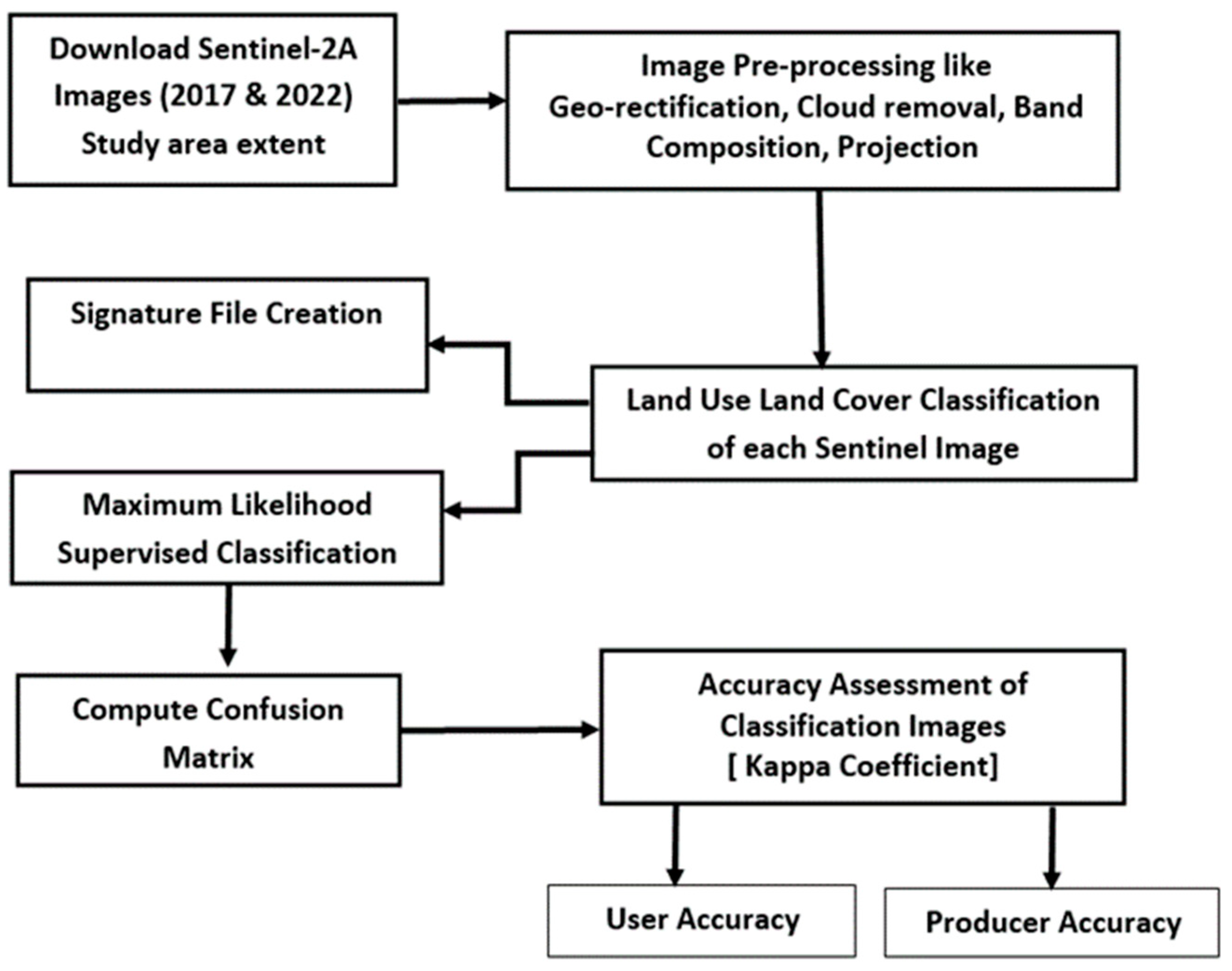
Figure 1.
Research Methodology Flowchart.
2.3. Machine Learning
Within Geographic Information Systems (GIS), Machine Learning has emerged as a crucial component for spatial analysis of geographic data. Applying Machine Learning tools and algorithms becomes essential to address various GIS-related challenges and enable effective geoprocessing of data. Regarding land cover classification, algorithms such as Support Vector Machines (SVM) [4] or Random Forests [5] can be employed. Clustering techniques prove valuable for processing large sets of input point data. Prediction algorithms, such as Geographically Weighted Regression (GWR) [6], offer the capability to model spatially varying relationships. These techniques allow for estimating unknown variables and making predictions based on spatial patterns and relationships in the data. Machine learning plays a crucial role in predicting and solving problems[23]. Similar to how humans learn from experience, machines learn through training data and continually improve based on that experience. In the field of GIS, machine learning finds applications in classification, segmentation, and prediction tasks.
In supervised image classification, the initial step involves defining the classification schema, which outlines the classes or categories of interest. Next, training sample polygons are collected, and training samples can also be automatically generated from GIS feature layers. These training samples are then inspected using cross-validation techniques to ensure their quality and representativeness. To train the classifier, appropriate classification methods are chosen based on the specific algorithm, such as Maximum Likelihood, Support Vector Machine, and Random Forests, among others. The training samples are provided as input to the chosen classification method. Finally, accuracy assessment and the creation of a confusion matrix are conducted to analyse the classifier performance, serving the needs of both the user and producer.
2.4. Algorithm
The “Maximum Likelihood Estimation (MLE) algorithm” [7] operates on two fundamental principles. Firstly, it assumes that the cell of each class sample in the multidimensional space follows a normal distribution. Secondly, it employs Bayes’ theorem principles for making decisions when assigning cells to different classes based on the signature file. The algorithm also takes into account the variances and covariances of signatures of the classes. By assuming the normal distribution of each class, the algorithm categorizes the classes using the mean vector and covariance matrix. However, it should be noted that the occurrence of certain classes may deviate from the average, resulting in either lower or higher frequencies. These weights are stated in the a priori file, assigning prior probabilities to the classes. Based on these weights, image pixels are assigned to their appropriate classes, improving the satellite image classification accuracy. This weighting approach to classification is commonly known as a Bayesian Classifier. When the algorithm is executed, it can generate a raster indicating the confidence level of the classification. This confidence raster provides an assessment of the reliability and certainty associated with the classification output.
The classification process of the downloaded satellite imagery from 2017 and 2022 involves utilizing the “Maximum Likelihood Algorithm” with supervised learning to classify the Land Use and Land Cover of the image using the Image Classification Tool. Based on specific band combinations, the images are classified into seven distinct classes: Dense Forest, Forest, Scrub, Grass, Waterbody, Built-up, and Deforestation.
Deforestation, in the context of land cover change, refers to the transition of a forested area to a non-forested land cover type, such as agricultural land, urban areas, or barren land. However, this process is not always a clear-cut or binary change; instead, it often involves a mixed or intermediate stage where remnants of the original forest coexist with other land cover types. Each class represents a different land cover type or land use category. Furthermore, the classified image area can be calculated based on each classification category, providing insights into the extent and distribution of different Land Cover and Land Use types in the study area. The concept of "mixed" land cover types during deforestation underscores the dynamic nature of land cover transitions. Recognizing these intermediate stages is critical for accurate classification and monitoring, particularly in regions undergoing gradual or fragmented deforestation processes.
Figure 2.
Land Use / Land Cover Classification Scheme of the study area.
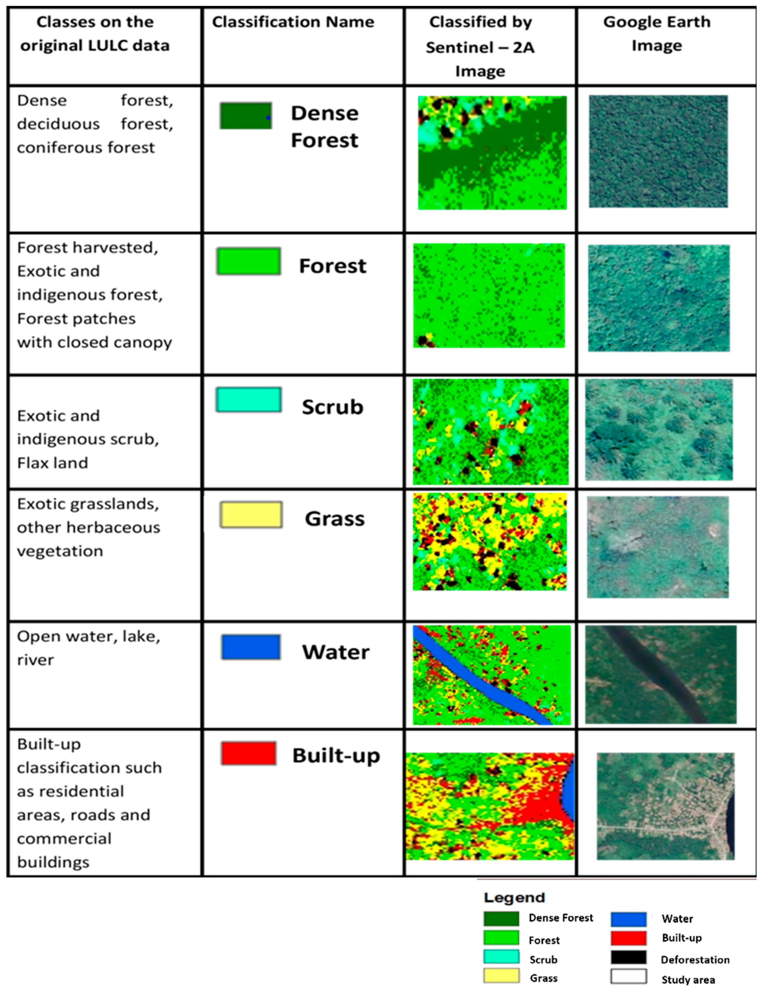
Figure 3.
Land Use / Land Cover classification based on Sentinel -2 image data acquired in 2017.
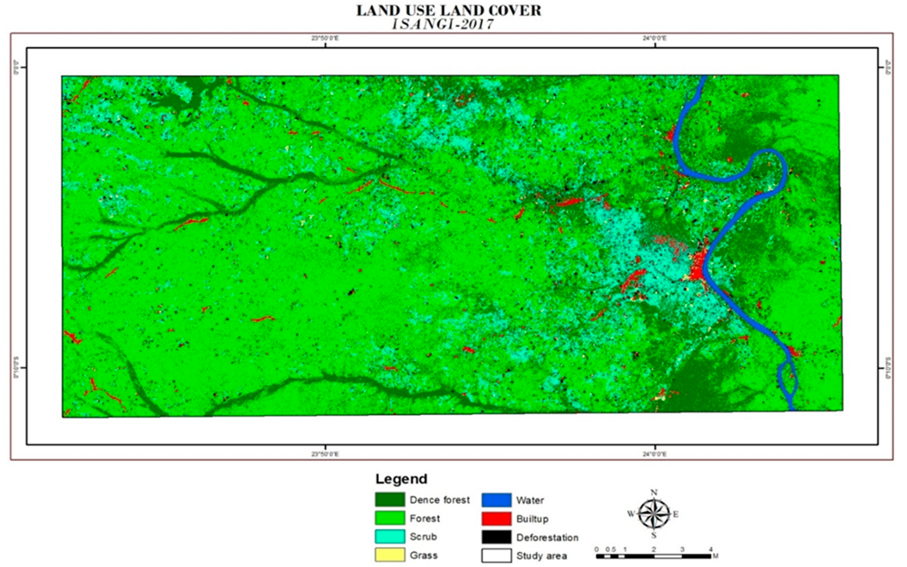
Figure 4.
Land Use / Land Cover classification based on Sentinel -2 image data acquired in 2022.
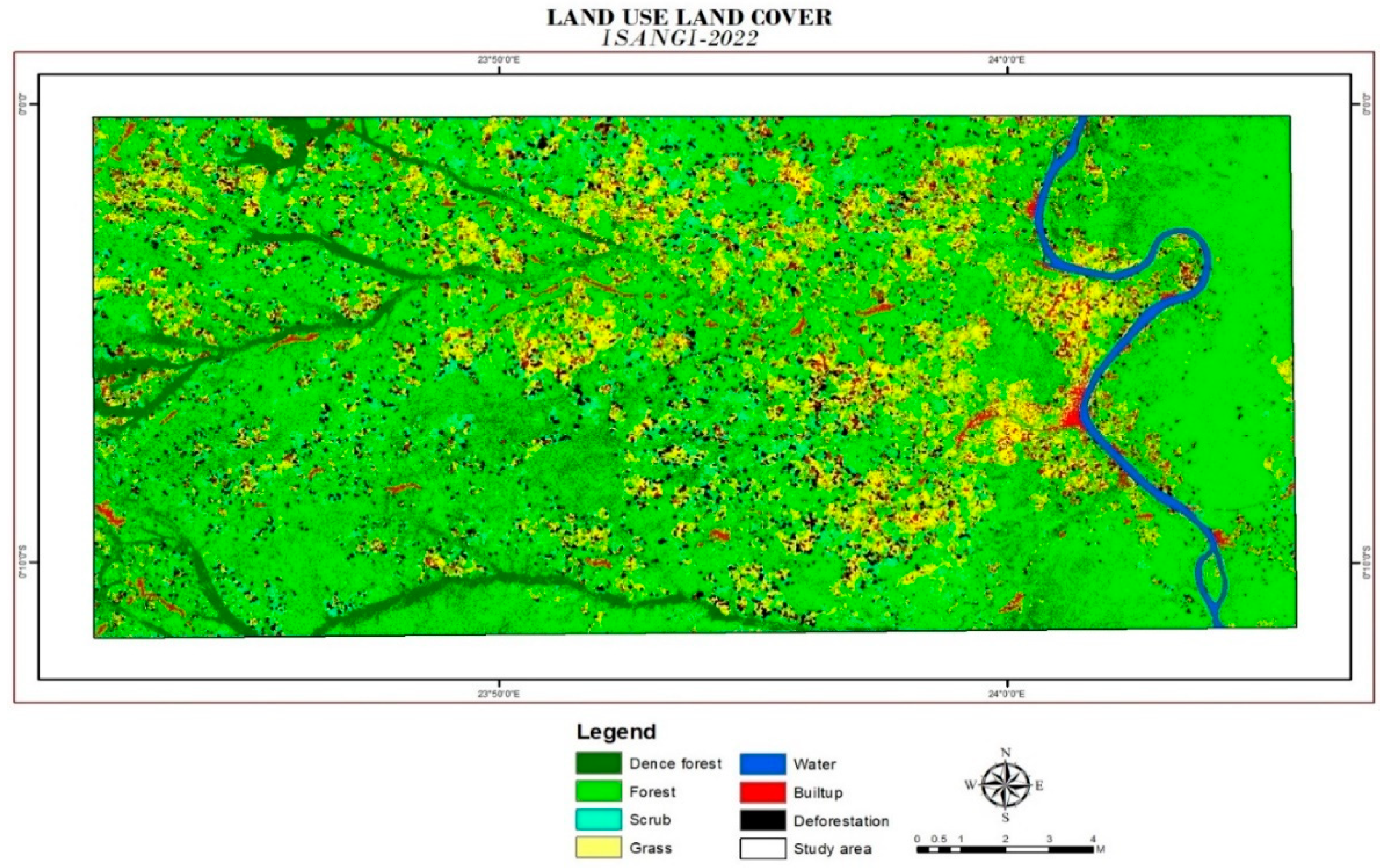
Following the classification of land use and land cover, the respective areas for the years 2017 and 2022 are computed. An area of approximately 8.5 km2 was affected by deforestation in 2017, while this value increased to about 32 km2 in 2022, marking a notable growth of 277%. As for built-up areas, there is an extent of about 28 km2 in 2017, which expands to approximately 54.7 km2 in 2022, accounting for a 91% increase. These calculations demonstrate that deforestation and built-up development primarily contribute to the disruption of forested regions, often due to human settlement and activities within those specific areas. Upon analyzing the Dense Forest, Forest, and Scrub categories, it becomes evident that the changes in the area from 2017 to 2022 are diminished. This trend underscores the heightened disturbance experienced by forested areas in comparison to other classifications.

Table 1.
Percentage of area change for each class.
| Class | Area (km2) 2017 | Area (km2) 2022 | Percentage of change |
|---|---|---|---|
| Dense forest | 213.8 | 113.8 | -47 % |
| Forest | 514.2 | 511.2 | -0.6 % |
| Scrub | 120.1 | 66.2 | -45 % |
| Grass | 16.8 | 124.1 | 639 % |
| Water | 9.5 | 9.6 | 0.8 % |
| Built-up | 28.7 | 54.7 | 47.532% |
| Deforestation | 8.5 | 32 | 277 % |
| Total Study Area | 911.6 | 911.6 |
3. Results
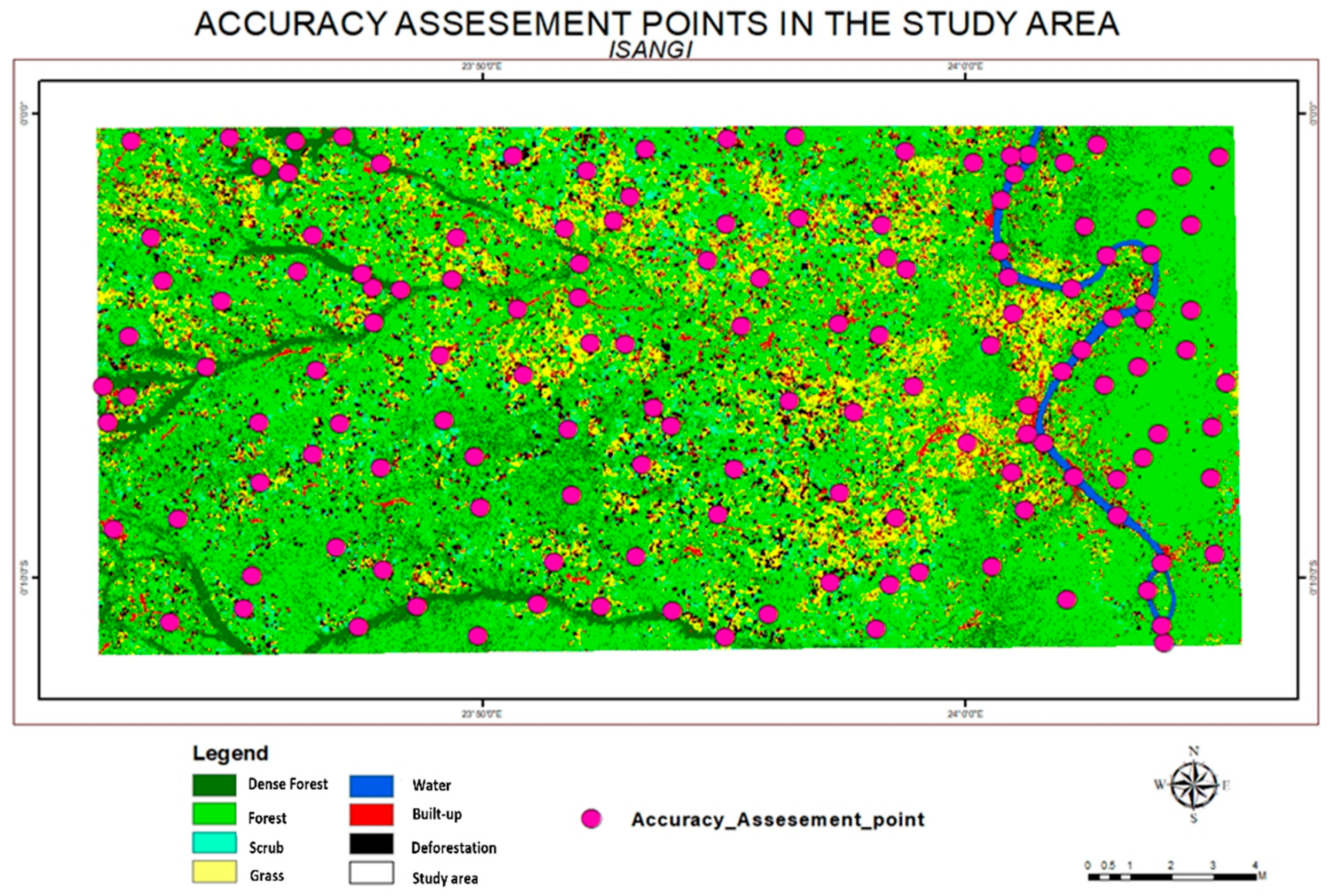
The accuracy assessment is a crucial metric for verifying users’ and producers’ accuracy during the validation processes. The validation points were collected using ArcGIS. Initially, a shapefile is generated, and the create feature tool is utilized to designate validation points within the land use and land cover (LULC) map of the study area. These points serve as a subset for computing the accuracy of the classified image. A total of 140 samples are carefully chosen, and the user values are manually entered into the attribute table based on the classification outcomes. Concerning producer values, a comparison of assessment points is conducted using the reference source, Google Earth. The validation procedure entails plotting the assessment point shapefile onto Google Earth, where each point is scrutinized to update the producer values in the attribute table. This validation procedure hinges on maintaining the ID and user value as reference points. Detailed user and producer attribute tables can be found in the appendix for further consultation. This section culminates in the creation of an accuracy table derived from the information in the user and producer attribute tables.
This section may be divided by subheadings. It should provide a concise and precise description of the experimental results, their interpretation, as well as the experimental conclusions that can be drawn.
Figure 5.
Accuracy assessment point of the study area marked in Google Earth.
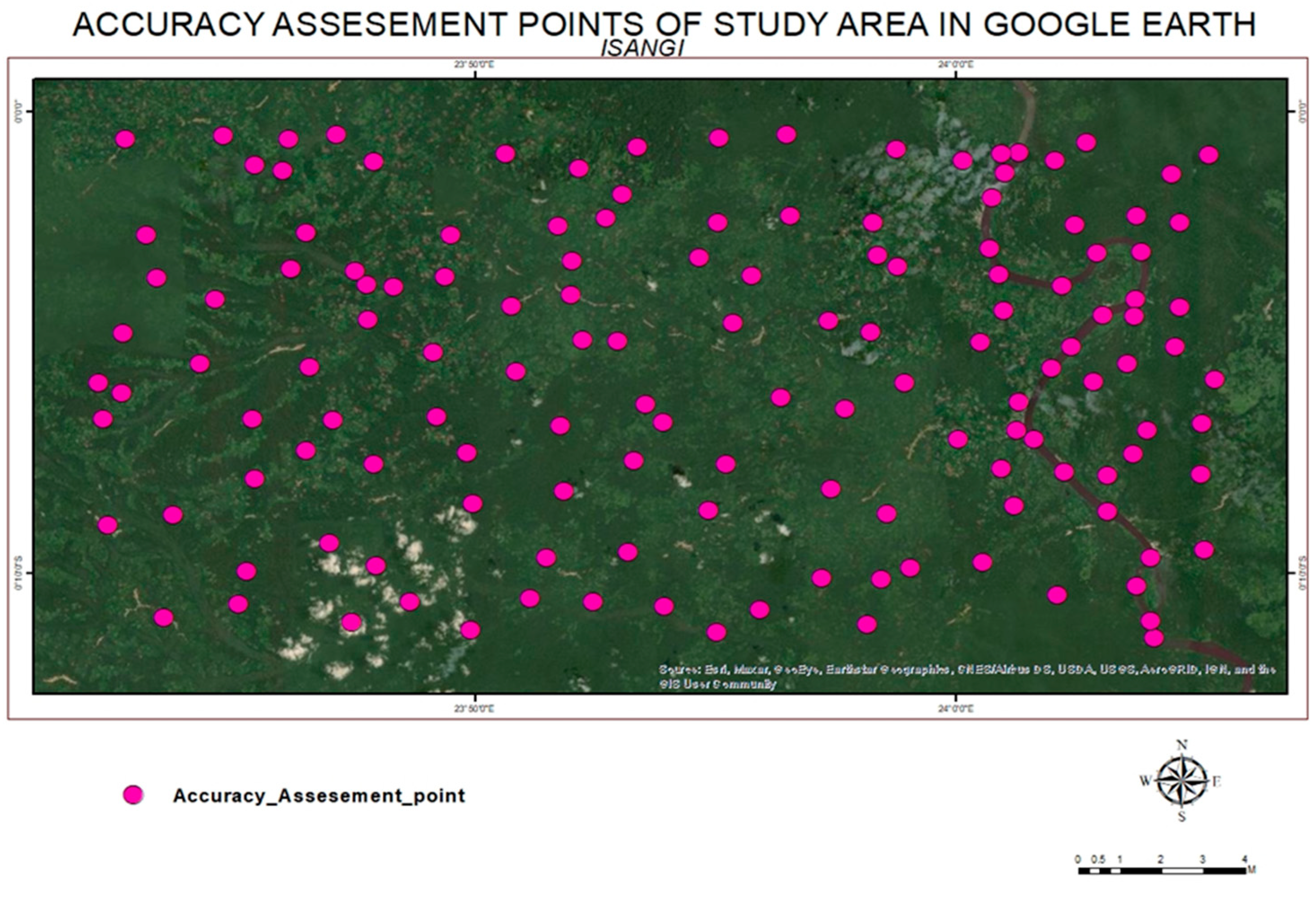
Figure 6.
Accuracy assessment points in the study area marked in ArcGIS.
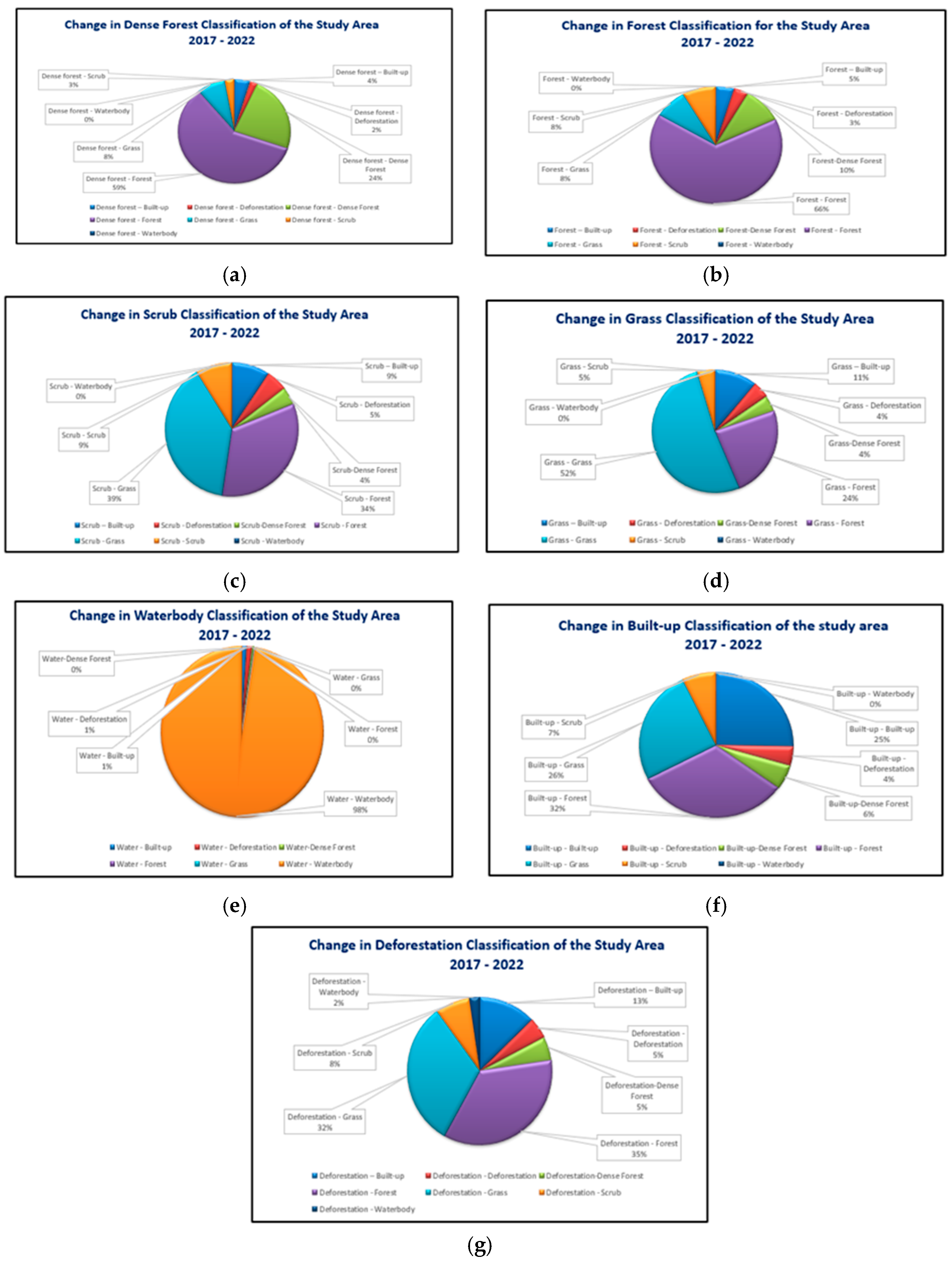
Following the classification of land use and land cover, the area of each specific classification is computed for both 2017 and 2022. In instances of deforestation, the area affected measures around 8.5 km2 in 2017, but by 2022, it expanded to about 32 km2, showcasing an increase of 277%. Similarly, for built-up areas, there is an extent of approximately 28.7 km2 in 2017, which grows to roughly 54.7 km2 in 2022, indicating a 91% rise. This area analysis makes it evident that deforestation and built-up expansion, typically attributed to human settlement and activities, significantly disrupt forested regions. When evaluating Dense Forest, Forest, and scrub classifications, the area changes demonstrate a decrease in 2022 compared to 2017. This pattern underscores that the forested areas experienced greater disturbance in contrast to other classifications.
Figure 7.
Pie Chart of the change in each classification in 2017 and 2022. (a) Change in dense forest classification (b) Change in forest classification; (c) Change in scrub classification; (d) Change in grass classification; (e) Change in waterbody classification; (f) Change in built-up classification; ((g) Change in deforestation classification.
Figure 7.
Pie Chart of the change in each classification in 2017 and 2022. (a) Change in dense forest classification (b) Change in forest classification; (c) Change in scrub classification; (d) Change in grass classification; (e) Change in waterbody classification; (f) Change in built-up classification; ((g) Change in deforestation classification.
3.1. Transition Matrix
A transition matrix is a numerical approach used to depict the precision of image classification [8]. Table 2 presents the confusion matrix, which corresponds between the classification image derived from Sentinel-2A and the validation points collected from the Google Earth Engine. Data such as the ground truth table, involving manual image digitization, contributes cartographic information for computing the transition matrix. Within this table 2, the cells showcase the changes in area for each classification relative to other classifications. The purpose of constructing this transition matrix lies in evaluating the accuracy of classification. Analyzing the confusion matrix aids in identifying error sources, offering potential avenues to enhance classification precision. The ArcGIS confusion matrix tool employs randomly selected accuracy assessment points to calculate the confusion matrix.
Table 2.
Transition Matrix of each Classification.
| LULC Classifications [2017 vs 2022] | Dense Forest | Forest | Scrub | Grass | Water | Built-up | Deforestation |
|---|---|---|---|---|---|---|---|
| Dense Forest | 49.40172 | 122.9154 | 5.562854 | 17.14876 | 0.082283 | 9.427003 | 4.558122 |
| Forest | 50.61457 | 342.2308 | 42.53785 | 42.52926 | 0.031243 | 23.72126 | 18.46864 |
| Scrub | 5.168365 | 40.26636 | 10.56561 | 46.75045 | 0.000056 | 11.217 | 6.333297 |
| Grass | 0.683915 | 3.854058 | 0.731505 | 8.287012 | 0.000056 | 1.780472 | 0.683915 |
| Water | 0.033925 | 0.015865 | 0.000421 | 0.000121 | 9.307755 | 0.091489 | 0.098786 |
| Built-up | 1.539542 | 9.106319 | 1.995702 | 7.205485 | 0.010755 | 7.133145 | 1.199203 |
| Deforestation | 0.438028 | 2.9335 | 0.645153 | 2.638639 | 0.185643 | 9.427003 | 0.38334 |
Table 3.
Accuracy assessment points table.
| Accuracy | Dense Forest | Forest | Scrub | Grass | Water | Built-up | Deforestation | Total User value |
|---|---|---|---|---|---|---|---|---|
| Dense Forest | 20 | 0 | 0 | 0 | 0 | 0 | 0 | 20 |
| Forest | 2 | 17 | 1 | 0 | 0 | 0 | 0 | 20 |
| Scrub | 0 | 1 | 19 | 0 | 0 | 0 | 0 | 20 |
| Grass | 1 | 0 | 0 | 18 | 0 | 0 | 1 | 20 |
| Water | 0 | 0 | 0 | 0 | 20 | 0 | 0 | 20 |
| Built-up | 0 | 2 | 1 | 0 | 0 | 17 | 0 | 20 |
| Deforestation | 0 | 1 | 1 | 0 | 0 | 0 | 18 | 20 |
| Total Producer Value | 23 | 21 | 22 | 18 | 20 | 17 | 19 | 140 |
3.2. User Accuracy Calculation
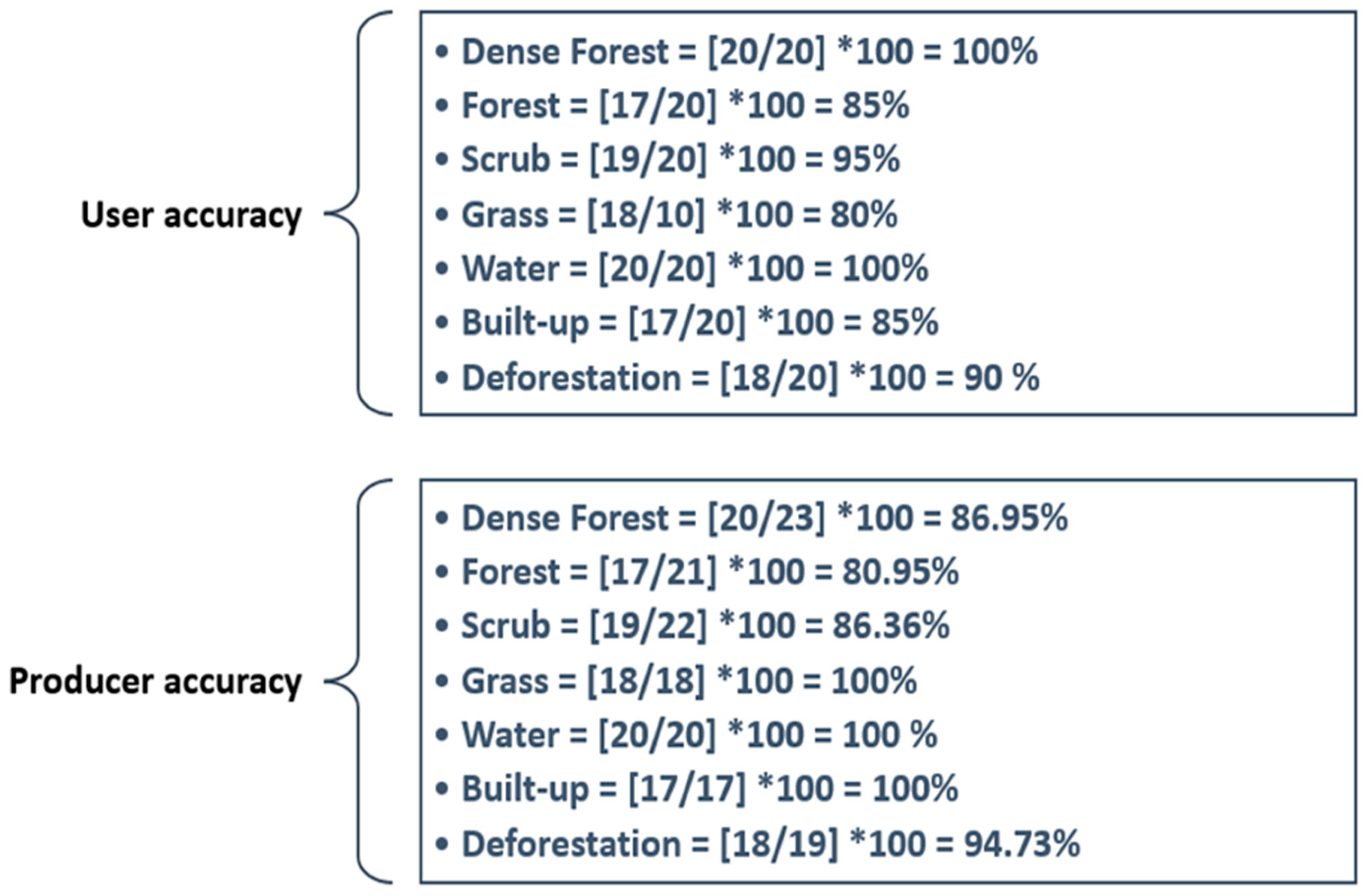
"User accuracy" is quantifiable through the division of the "number of pixels correctly classified" by the "total number of assessment pixels in each classification." The user accuracy metric signifies instances where the classified image inaccurately labels pixels, assigning them to a different user-defined value. This situation is also referred to as an error of commission. Converting the value to a percentage involves multiplying it by 100. For both built-up and forest classifications, the user accuracy stands at approximately 85%. On the other hand, dense forest and water body classifications yield a user accuracy of 100%.
where N – Number of correctly classified pixels
User accuracy = [N/S] *100
S – Total number of assessment pixels
3.3. Producer Accuracy Calculation
"Producer accuracy" is gauged by dividing the count of pixels correctly classified by the total count of assessment pixels within each classification. To express accuracy as a percentage, the calculated result is multiplied by 100. The producer accuracy aspect addresses instances of false negatives, where pixels belonging to a known class are erroneously classified as a different class. These misclassifications are updated in the attribute table and are commonly referred to as errors of omission. When examining forest classification, the producer accuracy for the forest category stands at 80.95%. For dense forest and scrub classifications, accuracy levels reach nearly 86%. Notably, grass, built-up, and waterbody classifications exhibit a perfect 100% producer accuracy.
where N – Number of correctly classified pixels
Producer accuracy = [N/S] *100
S – Total number of assessment pixels
Figure 8.
Calculation of user and producer accuracy for each classification.
The formula to calculate overall user accuracy is:
Overall User Accuracy = ∑ (Each classification user accuracy) / 7
= (635%)/7
= 90.71 %
The formula to calculate producer accuracy is :
Overall Producer Accuracy = ∑ (Each classification producer accuracy) / 7
= (648.99%) / 7
= 92.71 %
3.4. Kappa Coefficient Calculation
The kappa coefficient serves as an accuracy metric. It represents the accuracy evaluation points or samples used for classification. This coefficient quantifies the proportion of data within the accuracy assessment table's diagonal, and these figures can be influenced by anticipated chance values. Determining the "kappa coefficient" involves the multiplication of the overall assessment samples by the count of accurately classified samples. This calculation formula relies on the utilization of both the total sample count and the count of accurately classified samples.
The formula to calculate kappa coefficient accuracy is:
Kappa Coefficient Accuracy = [(Total samples *Total correctly Classified samples) - ∑(Total column value*Total row value)/(Total samples)2 - ∑(Total column value*Total row value)] *100
= [(140*129) -((23*20) +(21*20) +(18*20) +(20*20) +(17*20) +(19*20))/19600-((23*20) + (21*20) +(22*20) +(18*20) +(20*20) +(17*20) +(19*20))] *100
= [18060-(460+420+440+360+400+340+380)/19600 - (460+420+440+360+400+340+380)] *100
= [(18060-2800) / (19600-2800)] *100
= [15260/16800] *100
=90.83 %
The general accuracy is obtained through the division of the sum of correctly classified pixels by the total count of assessment pixels. To express this as a percentage, one should multiply the result by 100. By summing up the values on the diagonal, we arrive at 129 classified pixels out of a total of 140 assessment pixels.
The formula to calculate overall accuracy is:
where C -Total number of classified pixels
Overall Accuracy = [ P/ Q] *100
= [129/140] *100
= 92.14 %
A – Total number of assessment pixels
The classification achieves an overall accuracy of 92.14%, indicating that approximately 92% of pixels are accurately assigned, while around 8% of pixels have been assigned with errors. This level of accuracy is notably substantial.
4. Discussion
Thanks to the satellite imagery, we can get a birds view of the world look like from above. In the past, global deforestation was primarily driven by forest degradation. This involved clearing forests and replacing them with agricultural land, particularly in African regions. African forests were often cleared and burned to make room for local communities engaging in subsistence agriculture, as well as to acquire fuelwood for energy needs. Distinguishing between deforestation and degradation in the context of "shifting agriculture" has proven challenging and requires careful monitoring. As urbanization and expansion continue, Africa is shifting from localized practices to producing marketable agricultural goods and timber resources. Unlike the extensive research on the Amazon and Asian forests, the transformation of the Congo Basin forests has received less attention. The high rate of forest disturbances in the Congo Basin is primarily attributed to the rapid population growth in the region[13]. This ecoregion contains tropical forests that link various other forested areas in Africa, constituting the world's largest tropical forest expanse and playing a significant role in carbon production. Renowned for its biodiversity, the Congo Basin Forest serves as a habitat for numerous species. The principal factors contributing to forest disturbance include subsistence small-scale agriculture, as well as direct drivers such as mining, urbanization, and logging[20].
Satellite-based approaches have emerged as crucial tools for monitoring forest disturbances, providing real-time insights into new disruptions within forested areas. This technology enhances forest management practices and aids in the detection of illegal activities. To promote transparency and awareness regarding ongoing forest-related activities, essential data on forest disturbances are accessible on various websites, including the "Global Forest Watch" platform provided by the World Resources Institute.
Satellites equipped with high-resolution imaging sensors utilize long wavelengths of energy that can penetrate cloud cover and smoke. These radar-based satellite images are particularly valuable for identifying changes within the physical landscape of forests, especially in tropical regions. An example of such a satellite is the European Sentinel-2A, which offers 10-meter high-resolution radar data openly accessible for research purposes. This satellite-derived information significantly contributes to precisely assessing disturbances and effectively monitoring forests[41].
Upon obtaining results from these assessments, appropriate actions need to be implemented for forest management, conservation, and restoration in areas affected by both direct and indirect drivers of disturbance. Over an extended timeframe, a permanent driver of disturbance is "commodity-driven deforestation," which leads to lasting disruptions in forests due to activities like mining or agriculture. Similarly, urbanization serves as a long-term driver, transforming forests into infrastructure like roads, residences, and commercial structures. On a smaller to medium scale, "shifting agriculture" involves the temporary conversion of forests for the cultivation of crops or other commercial agricultural endeavors. Lastly, wildfires represent a temporary driver, causing transient damage to forests with the potential for subsequent regrowth.
An examination was conducted on the time-series analysis of the Normalized Difference Water Index (NDWI) from Sentinel-2 satellite images during the 2021 drought in Uttarakhand's Terai region, [42] Drought can impact areas with both high and low levels of precipitation. Typically, prolonged patterns of precipitation distribution in a specific region are considered normal[39]. However, this average precipitation might not adequately capture the nuanced variations in precipitation characteristics, particularly in arid locales. Additionally, evaluating the severity of drought proves challenging. Determination of drought severity is not solely dependent on the duration, intensity, and geographical scope of a single drought event; it is also influenced by the demands imposed by human activities and vegetation on a region's water resources.
Drought is defined by factors such as precipitation, evapotranspiration, and land surface temperature. Their fluctuations and impacts on the physical environment can be to some extent gauged using indices like the Standardized Precipitation Drought Index, the Standardized Multi-Band Drought Index, and the Normalized Difference Water Index (NDWI). Utilizing Sentinel-2 data, the study aimed to illustrate the ramifications of hydrological drought.
5. Conclusion
Measuring shifts, alterations, or losses in forests encompasses changes in forest cover, encompassing both losses due to deforestation and gains from afforestation efforts. The pace of deforestation has intensified, with the underlying triggers and spatial factors displaying significant variations across different times and regions—particularly pronounced in a vast and diverse nation like the Democratic Republic of Congo (DRC)[23]. Hence, safeguarding both the forests and the populace necessitates targeted interventions that consider spatial nuances. Spatial divisions are of vital importance not only on a localized scale but also in the context of transboundary factors. Conservation efforts and socio-economic advancements call for enhanced security measures and a substantial reduction in conflicts[29]. For effective implementation of forest disturbance detection methodologies, spatial and temporal considerations must be integrated into decision-making systems. In times of a pandemic, the vulnerabilities of low-income individuals and those living below the poverty line are exposed to global challenges. During such periods, trends within the DRC have shown signs of increased violence as the reliance on nature for basic survival amplifies. Providing robust ecosystems becomes imperative for those under the poverty line to confront future economic and climate uncertainties. To safeguard the environment, comprehensive forest monitoring is crucial, conveniently facilitated by satellite technology. Specifically, the Sentinel-2A satellite is employed here to "map changes in forest disturbances within the humid tropical forests of the Congo Basin[21]." The consistently accessible Sentinel-2A data at a 10-meter spatial resolution facilitates accurate detection of disturbances, even on a smaller scale, and allows confirmation through pixel-level analysis. This research underscores the utility of Sentinel-2A-derived time-series data for forest monitoring, which holds the potential for expansion to other regions. This methodology proves adept at identifying deforestation and forest degradation. The continual availability of data from Sentinel-2A supports long-term analyses[41]. Furthermore, this research employs machine learning techniques, both supervised and unsupervised, to enhance its approach. Supervised learning aids in time-series analysis of satellite imagery and change detection through land use and land cover classification. Defining sample points in the disturbance detection process enhances the precise assessment of affected areas.
This research serves the purpose of monitoring forests threatened by human activities, as well as addressing the potential impacts of forest degradation on ecosystems and biodiversity. Neglecting such vigilance could lead to social, economic, and environmental complications. Employing a forest monitoring or disturbance detection approach contributes to a comprehensive understanding of environmental changes. Integrating forest conditions into conservation practices necessitates prioritization, assessment, and appropriate action.
References
- Schnellnhuber, H.J. Avoiding Dangerous Climate Change. Cambridge University Press.
- Timothy Clifford, F. The Emissions Gap Report 2014: A UNEP Synthesis Report. United Nations Environment Programme.
- Xu, L.; Saatchi, S.S.; Shapiro, A.; Meyer, V.; Ferraz, A.; Yang, Y.; Bastin, J.-F.; Banks, N.; Boeckx, P.; Verbeeck, H. Spatial Distribution of Carbon Stored in Forests of the Democratic Republic of Congo. Sci. Rep. 2017, 7, 15030. [Google Scholar] [CrossRef] [PubMed]
- Noble, W.S. What Is a Support Vector Machine? Nature Publishing Group: London, UK, 2006; volume 24, pp. 1565–1567. [Google Scholar]
- Breiman, L. ‘Random Forests’. Machine Learning 2001, 45, 5–32. [Google Scholar] [CrossRef]
- Brunsdon, C.; Fotheringham, S.; Charlton, M. ‘Geographically Weighted Regression’. J. R. Stat. Soc. Ser. D (Stat.) 1998, 47, 431–443. [Google Scholar] [CrossRef]
- Otukei, J.R.; Blaschke, T. Land Cover Change Assessment Using Decision Trees, Support Vector Machines and Maximum Likelihood Classification Algorithms. Int. J. Appl. Earth Obs. Geoinf. 2010, 12, S27–31. [Google Scholar] [CrossRef]
- Congalton, R.G.; Green, K. Assessing the Accuracy of Remotely Sensed Data: Principles and Practices; CRC Press, 2019. [Google Scholar]
- Chen, N.; Tsendbazar, N.-E.; Hamunyela, E.; Verbesselt, J.; Herold, M. Sub-annual tropical forest disturbance monitoring using harmonized Landsat and Sentinel-2 data. Int. J. Appl. Earth Obs. Geoinformation 2021, 102, 102386. [Google Scholar] [CrossRef]
- Decuyper, M.; Chávez, R.O.; Lohbeck, M.; Lastra, J.A.; Tsendbazar, N.; Hackländer, J.; Herold, M.; Vågen, T.-G. Continuous monitoring of forest change dynamics with satellite time series. Remote. Sens. Environ. 2021, 269, 112829. [Google Scholar] [CrossRef]
- Tyukavina, A.; Hansen, M.C.; Potapov, P.; Parker, D.; Okpa, C.; Stehman, S.V.; Kommareddy, I.; Turubanova, S. Congo Basin forest loss dominated by increasing smallholder clearing. Sci. Adv. 2018, 4, eaat2993. [Google Scholar] [CrossRef] [PubMed]
- Reiche, J.; Mullissa, A.; Slagter, B.; Gou, Y.; Tsendbazar, N.-E.; Odongo-Braun, C.; Vollrath, A.; Weisse, M.J.; Stolle, F.; Pickens, A.; et al. Forest disturbance alerts for the Congo Basin using Sentinel-1. Environ. Res. Lett. 2021, 16, 024005. [Google Scholar] [CrossRef]
- Umunay, P.M.; Gregoire, T.G.; Gopalakrishna, T.; Ellis, P.W.; Putz, F.E. Selective logging emissions and potential emission reductions from reduced-impact logging in the Congo Basin. For. Ecol. Manag. 2019, 437, 360–371. [Google Scholar] [CrossRef]
- Kishor, N.; Lescuyer, G. (2012) Controlling illegal logging in domestic and international markets by harnessing multi-level governance opportunities Ubiquity Press, Ltd.
- Hansen, J.; Sato, M. Regional climate change and national responsibilities. Environ. Res. Lett. 2016, 11, 034009. [Google Scholar] [CrossRef]
- Reiche, J.; Lucas, R.; Mitchell, A.L.; Verbesselt, J.; Hoekman, D.H.; Haarpaintner, J.; Kellndorfer, J.M.; Rosenqvist, A.; Lehmann, E.A.; Woodcock, C.E.; et al. Combining satellite data for better tropical forest monitoring. Nat. Clim. Chang. 2016, 6, 120–122. [Google Scholar] [CrossRef]
- Vollrath, A.; Mullissa, A.; Reiche, J. Angular-Based Radiometric Slope Correction for Sentinel-1 on Google Earth Engine. Remote. Sens. 2020, 12, 1867. [Google Scholar] [CrossRef]
- Quegan, S.; Yu, J. Filtering of multichannel SAR images. Geosci. Remote Sens. 2001, 39, 2373–2379. [Google Scholar] [CrossRef]
- Antropov, O.; Rauste, Y.; Praks, J.; Seifert, F.M.; Häme, T. Mapping Forest Disturbance Due to Selective Logging in the Congo Basin with RADARSAT-2 Time Series. Remote. Sens. 2021, 13, 740. [Google Scholar] [CrossRef]
- Shapiro, A.C.; Grantham, H.S.; Aguilar-Amuchastegui, N.; Murray, N.J.; Gond, V.; Bonfils, D.; Rickenbach, O. Forest condition in the Congo Basin for the assessment of ecosystem conservation status. Ecol. Indic. 2020, 122, 107268. [Google Scholar] [CrossRef]
- Rahm, M.; Van Wolvelaer, J.; Vrieling, A.; Mertens, B. (2013) Detecting Forest degradation in the congo basin by optical remote sensing. 2013/12/1. pp. 19.
- Mitchell, A.L.; Rosenqvist, A.; Mora, B. Current remote sensing approaches to monitoring forest degradation in support of countries measurement, reporting and verification (MRV) systems for REDD+. Carbon Balance Manag. 2017, 12, 9. [Google Scholar] [CrossRef]
- Csillik, O.; Reiche, J.; De Sy, V.; Araza, A.; Herold, M. Rapid remote monitoring reveals spatial and temporal hotspots of carbon loss in Africa’s rainforests. Commun. Earth Environ. 2022, 3, 48. [Google Scholar] [CrossRef]
- Commission, E. , Directorate-General, f.E., Atzberger, C., Zeug, G., Defourny, P., Aragão, L., Hammarström, L. and Immitzer, M. (2020) Monitoring of forests through remote sensing : Final report. Publications Office.
- Reiche, J.; Mullissa, A.; Slagter, B.; Gou, Y.; Tsendbazar, N.-E.; Odongo-Braun, C.; Vollrath, A.; Weisse, M.J.; Stolle, F.; Pickens, A.; et al. Forest disturbance alerts for the Congo Basin using Sentinel-1. Environ. Res. Lett. 2021, 16, 024005. [Google Scholar] [CrossRef]
- Mitchell, A.L.; Rosenqvist, A.; Mora, B. Current remote sensing approaches to monitoring forest degradation in support of countries measurement, reporting and verification (MRV) systems for REDD+. Carbon Balance Manag. 2017, 12, 9. [Google Scholar] [CrossRef] [PubMed]
- Tyukavina, A., Hansen, M.C., Potapov, P., Parker, D., Okpa, C., Stehman, S.V., Kommareddy, I. and Turubanova, S. (2018) Congo basin forest loss dominated by increasing smallholder clearing American Association for the Advancement of Science (AAAS).
- Reiche, J.; Hamunyela, E.; Verbesselt, J.; Hoekman, D.; Herold, M. Improving near-real time deforestation monitoring in tropical dry forests by combining dense Sentinel-1 time series with Landsat and ALOS-2 PALSAR-2. Remote. Sens. Environ. 2018, 204, 147–161. [Google Scholar] [CrossRef]
- Csillik, O., Reiche, J., De Sy, V., Araza, A. and Herold, M. (2022) Rapid remote monitoring reveals spatial and temporal hotspots of carbon loss in africa’s rainforests Springer Science and Business Media LLC.
- Reiche, J.; Lucas, R.; Mitchell, A.L.; Verbesselt, J.; Hoekman, D.H.; Haarpaintner, J.; Kellndorfer, J.M.; Rosenqvist, A.; Lehmann, E.A.; Woodcock, C.E.; et al. Combining satellite data for better tropical forest monitoring. Nat. Clim. Chang. 2016, 6, 120–122. [Google Scholar] [CrossRef]
- Monitoring forest land from high altitude and from space [remote sensing applications in forestry. final report]. (1972).
- Potapov, P.; Turubanova, S.; Tyukavina, A.; Krylov, A.; McCarty, J.; Radeloff, V.; Hansen, M. Eastern Europe's forest cover dynamics from 1985 to 2012 quantified from the full Landsat archive. Remote Sens. Environ. 2015, 159, 28–43. [Google Scholar] [CrossRef]
- Hansen, M.C.; Egorov, A.; Potapov, P.V.; Stehman, S.V.; Tyukavina, A.; Turubanova, S.A.; Roy, D.P.; Goetz, S.J.; Loveland, T.R.; Ju, J.; Kommareddy, A.; Kovalskyy, V.; Forsyth, C.; Bents, T. Monitoring conterminous United States (CONUS) land cover change with Web-Enabled Landsat Data (WELD). Remote Sens. Environ. 2014, 140, 466–484. [Google Scholar] [CrossRef]
- Hansen, M.C.; DeFries, R.S.; Townshend, J.R.G.; Sohlberg, R.; Dimiceli, C.; Carroll, M. Towards an operational MODIS continuous field of percent tree cover algorithm: examples using AVHRR and MODIS data. Remote Sens. Environ. 2002, 83, 303–319. [Google Scholar] [CrossRef]
- Global Forest Watch. “Tree cover gain in Isangi, Tshopo, Democratic Republic of the Congo compared to other areas”. Accessed on 08/06/2022 from www.globalforestwatch.org.
- Zhang, Q.; Devers, D.; Desch, A.; Justice, C.O.; Townshend, J. Mapping tropical deforestation in central Africa. Environ. Monit. Assess. 2005, 101, 69–83. [Google Scholar] [PubMed]
- Megevand, C.; Mosnier, A.; Hourticq, J.; Sanders, K.; Doetinchem, N.; Streck, C. Deforestation Trends in the Congo Basin: Reconciling Economic Growth and Forest Protection; World Bank: Washington, DC, USA, 2013; 179p. [Google Scholar]
- Ygorra, B.; Frappart, F.; Wigneron, J.P.; Moisy, C.; Catry, T.; Baup, F.; Hamunyela, E.; Riazanoff, S. Monitoring loss of tropical forest cover from sentinel-1 time-series: A CuSum-based approach. Int. J. Appl. Earth Obs. Geoinf. 2021, 103, 102532. [Google Scholar] [CrossRef]
- Kellndorfer, J.; Cartus, O.; Lavalle, M.; Magnard, C.; Milillo, P.; Oveisgharan, S.; Osmanoglu, B.; Rosen, P.A.; Wegmüller, U. Global seasonal Sentinel-1 interferometric coherence and backscatter data set. Sci. Data 2022, 9, 1–16. [Google Scholar] [CrossRef]
- RUDEL, T.K. Deforestation trends in the congo basin: Reconciling economic growth and environmental protection by carole megevand with aline mosnier, joel hourticq, klas sanders, nina doetinchem and charlotte streck washington, DC: World bank, 2013. pp. 158. £18·50 (pbk). J. Mod. Afr. Stud. 2014, 52, 510–511. [Google Scholar]
- Li, J.; Roy, D.P. A global analysis of sentinel-2A, sentinel-2B and landsat-8 data revisit intervals and implications for terrestrial monitoring. Remote Sens. 2017, 9. [Google Scholar] [CrossRef]
- Manurung, A.E.; Balzter, H.; Espirito-Santo, F. Analysis of Drought at Terai Regions in Uttarakhand using Multiple Remotely Sensed Data. In Proceedings of the 2022 IEEE International Conference on Aerospace Electronics and Remote Sensing Technology (ICARES), Yogyakarta, Indonesia; 2022; pp. 1–7. [Google Scholar] [CrossRef]
Disclaimer/Publisher’s Note: The statements, opinions and data contained in all publications are solely those of the individual author(s) and contributor(s) and not of MDPI and/or the editor(s). MDPI and/or the editor(s) disclaim responsibility for any injury to people or property resulting from any ideas, methods, instructions or products referred to in the content. |
© 2024 by the authors. Licensee MDPI, Basel, Switzerland. This article is an open access article distributed under the terms and conditions of the Creative Commons Attribution (CC BY) license (http://creativecommons.org/licenses/by/4.0/).
Copyright: This open access article is published under a Creative Commons CC BY 4.0 license, which permit the free download, distribution, and reuse, provided that the author and preprint are cited in any reuse.


