

Submitted:
21 October 2024
Posted:
23 October 2024
You are already at the latest version
Abstract
The correlation of periodic seasonal vertical ground movement (SVGM) with climatic data from earth observation was investigated in this work. The European Ground Motion Service (EGMS) vertical ground movement measurements, provided from 2018 to 2022, were compared with temperature and precipitation data from MODIS and CHIRP datasets respectively. Measurement Points (MP) from EGMS over Italy provided a value of ground vertical movement approximately every 6 days. Precipitation and temperature datasets were processed to provide Drought Code (DC) maps calculated ad hoc for this study at 1 km spatial resolution and daily temporal resolution. Seasonal patterns were analysed to assess correlation with Spearman’s rank correlation coefficient (ρ) between this measure and DC from Copernicus CEMS (DCCEMS) and from MODIS+CHIRP (DC1km) and from temperature. Results over the considered area (Italy) showed that 0.46% of all MPs (32 826 MPs out of 7 193 676 MPs) have a ρ greater than 0.7: 12 142 of those have positive correlation, and 20 684 have negative correlation. DC1km was the climatic factor that provided the higher number of correlated MPs, roughly giving +59% more correlated MPs than DCCEMS and +300% than temperature data. If ρ greater than 0.8 was considered, the number of MPs drops by a factor of 10; from 12 142 to 1 275 for positive correlation and from 20 684 to 2 594 for negative correlation between DC1km values and SVGM measurements. Correlations lagged in time resulted in most of the correlated MPs being inside a window of +/- 6 days (a single satellite overpass time). Because DC and temperature are strongly co-linear, further analysis to assess which is better at explaining the seasonality of MPs was carried out, resulting in DC1km significantly explaining more variance of the SVGM than temperature for the inversely correlated points more than the directly correlated points. Spatial distribution of correlated MPs shows that they are unevenly distributed in clusters the Italian territory. This work will lead to further investigation both at local scale and at a pan-European scale. An interactive WebGIS application open to the public is available for data consultation. Data are shared in a public repository for replication of the method.
Keywords:
Subsidence
; drought
; seasonal vertical ground movement
; SAR
; Sentinel-1
; Interferometric Synthetic Aperture Radar (InSAR)
1. Introduction
Seasonal vertical ground movement (SVGM) refers to the vertical displacement of the ground surface which follows harmonic trends recurring every year and primarily driven by changing seasons. This displacement can manifest as either uplift (upward movement) or subsidence (downward movement), resulting in changes in surface elevation and posing significant threat to infrastructure, agriculture and environmental sustainability [2] and even playing a role in inundation scenarios from sea level rise [3]. SVGM is also a proxy to other phenomena that cause deformation of the Earth surface. Various factors drive SVGM, many of which are related directly or indirectly to climate, i.e. temperature and precipitation. Natural factors such as compaction of sediments, geological processes and anthropogenic factors such as groundwater withdrawal are major contributors.
Temperature plays a significant role in SVGM. Directly, temperature fluctuations cause thermal deformation of infrastructures - like buildings and roads - which can lead to deformation of the infrastructure on the Earth surface. Indirectly, temperature affect the moisture content in soils and sediments, affecting their compaction and expansion. For instance, prolonged periods of high temperatures with little or no precipitation can lead to drought conditions, causing the ground to dry out, compact and result in subsidence. Conversely, in cooler, wetter seasons, soils absorb moisture, swell and cause uplift. This process can be understood through the principle of effective stress [4]: as soil moisture increases, pore water pressure rises, reducing effective stress and causing uplift. In contrast, during droughts, reduced soil moisture decreases pore water pressure, increasing effective stress and leading to subsidence ([5,6]). Thus, investigating the relation between these variables (temperature and drought) and SVGM will be crucial for proactive risk management and mitigation strategies.
SAR, known as Synthetic Aperture Radar, is one technique used for measuring ground deformations [7,8]. It is a form of radar imaging used to create detailed images of landscapes and objects on it and provide detailed information on ground deformation, allowing for the detection and geodetic measurement of SVGM with unprecedented accuracy [9] and with high spatial and temporal resolution. It has an antenna system that sends electromagnetic pulses at an angle towards the earth to create image strips about 100 km wide. By using two SAR images acquired either by two different antennas or by repeated passes, it is possible to use the phase measurements to determine the relative distance of an object as a fraction of the radar wavelength (in the case of repeated passes of the radar over the same area) and the difference in the sensor locations (in the case of the antenna(s) at different positions) to determine angular differences useful for topographic mapping [10].
The superimposition of these images, known as Interferometric SAR (InSAR), produces an interferogram that reveals phase differences between the signals received by the radar instrument. This phase difference serves as an indicator of what has changed on the observed surface. Ignoring the impact of atmospheric delays during the travel of the signal, the phase difference is obtained from the contributions of the interaction of the signal with the ground surface, the satellite’s position in orbit and the topography. By making repeated passes over an area and multiple observations, these contributions can be modelled, allowing for the phase difference to be modelled and to derive the expected surface change.
This study used SVGM determined from processing InSAR data provided by the European Ground Motion Service (EGMS) for the period 2018 to 2022 to examine correlation with two key climatic variables: drought and temperature.
Specifically, drought conditions were assessed using the Drought Code (DC) from two sources: (i) the Copernicus Climate Change Service (C3S) Climate Data Store (CDS), labeled as , and (ii) a 1 km resolution DC map calculated ad-hoc for this study, labeled as . In addition, the influence of temperature on SVGM will be analyzed using its thermal deformation effect on infrastructures.
DC, traditionally used to infer forest fire risk, was used here as a proxy of drought due to the fact that DC represents the condition of a layer that dries very slowly [11], with a time lag of ≈ 52 days [12]. This means that it reflects long-term drought conditions, which we hypothesize - together with temperature - as having significant correlation with SVGM, especially in areas of intense agricultural activity [13]. To quantify this correlation, Spearman’s rank correlation coefficient was used. The main objectives for this study were as follows:
- to investigate the correlation between SAR-derived SVGM and climatic conditions (drought and temperature) in Italy, examining whether drought events coincide with changes of surface elevation and ground motion patterns.
- to identify regions within Italy where SAR-derived land subsidence and drought conditions exhibit cluster patterns.
- to assess the implications of the identified correlation points and areas with specific causes.
2. Materials
2.1. Study Area
This study focused on Italy as study area. The Italian territory is located in southern Europe and stretches between longitudes and E and latitudes and N. In the north, Italy shares border with France, Switzerland, Austria and Slovenia. The rest of the territory is surrounded by water, with the Adriatic sea to the east, the Tyrrhenian Sea to the west and the Mediterranean and Ionian seas to the south. Italy is characterised by diverse landscapes, featuring the Alps mountain and the Po Valley in the north. The Po Valley, one of the most significant agricultural regions is known for its fertile plains and dense urban centres, posing an ideal study area due to these different land-cover categories and varied geology.
Italy’s climate varies significantly across its regions, ranging from a humid subtropical climate in the north, influenced by the Alps and the Po Valley, to a Mediterranean climate in the southern coastal areas. There is also a different climatic scenario between the northern and southern regions, with the central part of the country including Tuscany and Umbria acting as a transitional zone between these two climatic zones. The north typically experiences colder winters and hot summers, while the south generally has milder winters and warmer temperatures throughout the year. For example, on a winter day, temperatures can vary greatly: it may be around and snowing in Milan (north), in Rome (central), and in Palermo (south). This variation is often depicted on weather maps showing temperature gradients across the country. Consequently, there is an associated trend in loss of soil moisture and drought conditions across the country. Vertical ground deformation is a prominent issue in Italy driven by factors such as the extraction of groundwater for agricultural and industrial activities, tidal influence (e.g. in Venice) and active volcanoes in the South [14]. Climate related variables also have significant impact over the region. For instance, in July 2022, there was an intense drought in Italy (Figure 1), more than what the country has experienced in the past 70 years, because of which the government declared a state of emergency over 5 regions in the Northern territory (Emilia-Romagna, Friuli-Venezia Giulia, Lombardy, Piedmont and Veneto). This happened as a result of the extreme heat which had a resulting impact on the winter snow in the region. Also, the preceding months had a low amount of recorded rain thus intensifying the drought. These climatic and environmental challenges make Italy a suitable area of interest for this research.
2.2. Data
The primary datasets utilized in this study are summarized in Table 1. These include: (i) the European Ground Motion Service (EGMS) ground movement time-series, (ii) Land Surface Temperature (LST) data from the Moderate Resolution Imaging Spectroradiometer (MODIS), (iii) precipitation data from the Climate Hazards Group Infrared Precipitation with Station Data (CHIRP) dataset and (iv) drought code from Copernicus CEMS cems-fire-historical-v1.
3. Methods
This section describes the methods used to quantify the correlation between SVGM and the climatic variables, focusing on the use of Spearman’s rank correlation coefficient () for assessing the monotonic relationship between ground movement and temperature and drought codes time series .
3.1. Drought Indices
Drought indices are tools used to quantify and monitor drought conditions by integrating weather variables, commonly temperature and precipitation of the area of interest. These indices consider rainfall deficiencies over long periods that impact the moisture content of soils. In this work, we use the index known as the Drought Code (DC) developed from the original Drought Index of the Canadian Danger Rating Systems [19]. The original Drought Index had important limitations as its upper limit of 25 drying days was reached quickly during extended drying periods. The Drought Code (DC), which is used in this study, was developed from the stored moisture index (SMI) to overcome this limitation and standardised with other indices. Drought Code uses temperature and precipitation and takes into consideration the number of drying days, e.g. days with no rainfall or no effective rainfall. This information is integrated with an estimate of evapo-transpiration that removes moisture from the ground. The DC index supports the estimation of various impacts of drought on the Earth surface. In this study we use daily temperature and precipitation data to estimate daily maps of DC values for the study area. Time-series of these values are then used to calculate correlation with SGVM.
3.1.1. Air Temperature Estimation
The MODIS Daytime Land Surface Temperature (LST) product (MOD11A1 V6.1) was used to estimate the temperature at MPs’ positions for the intended period and calculate DC values (see equations 1-6). It must be noted that LST and air temperature are not equivalent, even if co-linear, and that there are different sets of spatio-temporal characteristics that distinguish them [20]. LST refers to the temperature of the Earth’s surface measured within a few meters above the ground surface. Air temperature on the other hand is measured at a height of approximately 1.5 to 2 meters [21] above the ground. Using LST directly is not an ideal solution because we would be assuming that it matches air temperature. Air temperature is the input needed for DC calculation. Thus, a correction factor of 0.74 was used to correct differences between LST and air temperature in accordance with the recommendation of [20].
It should be noted that temperature rasters have plenty of gaps in time and space due to low-quality pixels, usually from clouds or other limitations from the atmosphere or from sensor malfunctions. To fill these gaps, a spline interpolation was applied to estimate values in empty cells. The final product is a continuous map at 1 km resolution of daily temperature for the 5 year period considered in this study. The map is available for download [22].
3.1.2. Precipitation
Daily precipitation estimated values were obtained from the CHIRPS dataset. The CHIRPS dataset is a global rainfall dataset provided by the United States Geological Survey and the Climate Hazards Center. It incorporates resolution satellite imagery (that is based on infrared Cold Cloud Duration Observations) with in-situ station data to create gridded rainfall time series using interpolation approaches [23]. It is available on a daily, monthly or seasonal basis and also useful for performing trend analysis and seasonal drought monitoring making it valuable for this work. The dataset was clipped to the study area, exported and used for the estimation of the drought code.
3.1.3. Drought Code (DC)
Drought Code is an indicator of the moisture content in deep compact organic layers. This code represents a fuel layer approximately 10-20 cm deep. The drought code fuels have a very slow drying rate, with a time lag of 52 days. The drought code scale is open-ended, although the maximum value is about 800 [24] . In this work, two versions of drought code maps are tested. One is the reanalysis grid cell resolution of ( km) dataset provided by Copernicus CEMS cems-fire-historical-v1. This will be referred to as . The other version of the drought code map was computed ad-hoc with a spatial resolution of 1 km. This was estimated using the precipitation and temperature datasets described in Section 3.1.2 and Section 3.1.1 respectively and will be referred to as .
was calculated based on rainfall values from CHIRP of the day () and the DC value of the previous day () with the following equations:
If rainfall is equal to or above 2.8 mm it is considered effective rainfall and the following equations are then used to update the DC value with respect to DC value of the previous day:
where:
- is the drought code from rainfall data of the day,
- is the moisture equivalent that is calculated from the moisture equivalent of the previous day, , which is in turn calculated from , i.e., the DC code of the last day,
- is the rainfall of the day in mm from the CHIRP dataset,
- is the amount of rain available for storage in forest soil after interception by the canopy.
In case of rainfall below 2.8 mm, DC value for the day is updated based on the temperature at mid-day and , i.e., the DC code of the previous day with the following equations:
where:
- is the temperature at mid-day, here estimated from the MODIS LST converted to air temperature by a factor of 0.74 as documented,
- is a day-length factor which is constant for each month and is -1.6 for the months of November through to March, and 0.9, 3.8, 5.8, 6.4, 5.0, 2.4, 0.4 respectively for the months from April to October.
3.2. Seasonal Vertical Ground Movement Estimation
The EGMS is one of the 6 main Copernicus Land Monitoring Services and uses InSAR data derived from Sentinel-1 to detect and measure ground movements across Europe with millimetre precision. It provides 3 main InSAR products: basic (Level 2a), calibrated (level 2b) and ortho (level 3). A summary of these product categories are here provided and further details could be obtained from the technical report [25].
3.2.1. Basic EGMS Product
The EGMS Basic product provides displacement measurements along an imaginary line - referred to as the line-of-sight (LOS) - connecting the satellite to the ground target referred to as the measurement point (MP). The displacement along the line of sight is re-projected to derive the vertical/horizontal displacement at the MP. These products are also provided from SAR data acquired orthogonal to the ascending or descending trajectory of the satellite. The basic products are spatially referenced to a virtual reference point (whose time series is derived by a statistical analysis of the dataset) and temporally referenced to an initial starting time (=0).
Each basic product uses a virtual reference point derived from statistical analysis of the dataset within its specific processed area. Thus, the reference point might vary for different products even for the same area. Thus, direct comparison between different products of this level might produce inconsistent results as the displacement measurements are relative to their own reference points.
3.2.2. Calibrated EGMS Product
The EGMS calibrated product is an advanced version of the basic product in which displacements are measured with reference to an Earth centred reference frame model derived from GNSS time series data, thereby making the measurements absolute. Thus, a result that is more consistent would be obtained when comparing different products of displacement from same or adjacent areas. However, GNSS data might not be available for some areas, especially isolated islands. In this case, the basic products are harmonised with each other and the mean ground velocity adjusted to zero, making the measurement internally consistent and comparable within the local context using the InSAR data. The calibrated products are also provided from SAR data acquired orthogonal to the ascending or descending trajectory of the satellite.
3.2.3. Ortho EGMS Product
The EGMS ortho product exploits measurement of displacement from the calibrated products, breaking it down into two components (vertical and east-west displacements) resampled to a 100 m grid to coincide with the other Copernicus products. This simplifies interpretation of the data as it removes the need to consider the original geometry of the satellite data acquisition. It also allows interpretation of displacement along a particular direction (for instance in the case of a landslide).
Among others, the ortho product has the limitation that Sentinel-1 satellite uses side-looking radar in a near-polar-orbit. Thus, the radar is less sensitive to ground displacements along the satellite’s flight path (i.e. in the north-south direction). As a result, MP displacements in the north-south direction will not be measured directly by InSAR but inferred from the GNSS data introduced in the calibrated products [25]. Since GNSS data has a lower spatial resolution compared to InSAR measurements, displacements along the north-south direction are estimated through spatial interpolation from the available data.
For this study, the EGMS ortho product was used due to advantages it offers.
3.3. Assessment of Correlation between SVGM and Climate Indices
Climate-driven correlations with seasonal vertical ground movement (SVGM) from InSAR was the focus for analysis in this work. By "seasonal" it is meant that uplift and subsidence of the ground level follows a periodic pattern repeating every year. To assess correlation with climate indices, the data of EGMS ground displacement is detrended over the whole monitoring period. This is necessary to remove long-term trends in the time-series of the ground movement for each measurement point (MP). The goal was to assess SVGM in terms of recurring patterns (harmonic patterns) and if, where and how, these patterns are correlated to climate. This analysis was carried out at the location of all MPs recorded by the EGMS Ortho product. Proxies used for climate are the two Drought Code maps (, ) and the temperature from MODIS.
Spearman’s rank correlation coefficient was calculated at each MP, as it is more robust to relations which are not linear throughout the range of values. Both positive and negative correlations were considered. Positive correlation when there is a ground uplift with higher values of the compared independent variables (, and temperature), Negative correlation is when the ground subsides when the climate index values increase. Both behaviours have been observed and documented in past scientific literature. For instance, a positive correlation is often found in cases where infrastructures exhibit seasonal expansion due to thermal effects [26].
3.4. Development of WebGIS Application
As a side-product of the research, a WebGIS application was developed in R using the Shiny and Leaflet libraries to interactively visualise the spatial distribution of the MPs. This application was developed to serves as a platform for visual inspection of the spatial and temporal correlation between SVGM and the climate-related variables at the MPs. It is available for detecting hotspots of the phenomena of climate-driven SVGM and for pursuing further analysis.
4. Results
Each EGMS tile that covers land contains approximately 150,000 MPs; 92 tiles were used to cover the study area. Each measurement point was a vector with of time-series of ground displacement values, measured approximately every 6 days. For the 5 year period being considered for this study (2018-2022), about 300 observations for each MP were available. The corresponding DC values at each point were obtained using the Copernicus CEMS data () with resolution and our own data calculated from MODIS and CHIRP () datasets. The Spearman rank correlation, p-value and confidence interval were the results used to assess the correlation at each MP between seasonal patterns of ground vertical movement and drought and temperature.
4.1. InSAR Seasonal Vertical Ground Movement Correlations
Results of seasonal correlation patterns using Spearman’s rank correlation coefficient () between ground vertical motion and , and temperature show a significant number of points with high correlation, both negative and positive. The total number of MPs over Italy is 7 193 676. The total number of correlated points is 28 957, thus less than 0.4% (Table 2). Quite clearly only a minor part of the points are correlated. Figure 2 shows the distribution of the () values for all MPs over the study area [1].
From Table 2, it can be seen that a total of 1275 MPs have positive correlation coefficients between map and SVGM measurements above 0.8 and 2594 have below -0.8 (negative correlation). Correlations lagged in time were also analysed where it was observed most of the correlated MPs have stronger correlation at the day for which they were calculated (0 days lag time, Figure 3).
The above observation does not hold true for temperature, where lag time improved the correlation significantly. Figure 4 shows that a month’s negative lag time give the best correlation for negatively correlated MPs.
4.1.1. vs
Initial results over Italy show that is significantly better correlated to SVGM than , with a stronger median absolute value of of 0.025 and 0.042 respectively for negative and positive correlation scenarios. Figure 5(a), shows this difference as the scatter points are mostly on the right of the 1:1 diagonal line for negative correlation and vice-versa on positive correlation. This means that most points with negative correlation regarding ground motion patterns with respect to DC, show that, for - pairs, is usually more negative (stronger negative correlation). The opposite is true for positive correlation scenarios. Kruskal-Wallis pairwise difference of medians provides a -value of significant difference <0.001.
4.1.2. DC and Temperature
Because DC and temperature are strongly collinear, further analysis to assess which is better at explaining the seasonality of ground motion was carried out. Results shown in Figure 5 (b) show that significantly explains more variance than temperature if we consider negative correlation. Positive correlation with SVGM has mixed components, but most seem to be temperature driven.
4.2. Spatial Distribution of MPs in Italy
Figure 6 shows the overall spatial distribution of MPs with significant positive and negative correlations. The top row shows hexagonal cells of 10 km diameter with the percentage of EGMS MPs that have values of above or below 0.7. The bottom row shows the hot-spots in Italy which have a very large number of MPs with positive correlations and are thus worth further investigating.
4.3. Data Availability and Web-GIS Data Viewer
An open dataset consisting of three raster grids and a vector of MPs was an intermediate result from this study. These data are shared publicly to provide replicable methodology and share with other investigators [22]. The layers in the dataset are the following:
- grid with daily precipitation (mm)
- grid with daily air temperature interpolated values (°C)
- grid with calculated drought code (no unit)
- point vector with extracted MPs with correlation (||>0.7).
The first three datasets have one band per day from 1 January 2017 to 1 January 2023, thus a total of 2192 bands. It should be noted that the EGMS data covers from 1 January 2018. The data layers calculated for this study start from 2017, one year before the EGMS data (2018), because the DC calculation requires precipitation and temperature information from previous days to be reliable. Thus the first months of 2017 were estimated for accurate calculation of the layer, but only the ones from 2018 to 2023 were used, to match the EGMS data temporal coverage. All data are in geographic coordinate systems using the WGS84 system and aligned to an extent of , , , with a ground sampling cell distance of (). All four data layers are available as per F.A.I.R. (Findable, Accessible, Interoperable, and Reusable) guiding principles for research data stewardship and are provided as open-access - see [22].
The developed WebGIS application presents a map of the MP stations and has tools for user interaction with the map. On clicking on an MP, a pop-up window is displayed showing the following attributes for the , and temperature variables in addition to the longitude () and latitude coordinates() of the MP stations (see samples on Figure 7):
- coordinates of MP
- Spearman’s rank correlation ()
- confidence interval
- highest at lagged time
- lag (days)
Figure 8 also shows the time-series plots that can be automatically extracted by the user at selected MPs. These are useful for further exploratory analysis.
The objective of this work was to detect and analyse MPs that have a significant correlation of periodic ground movements with drought and temperature. Spearman’s rank correlation coefficient was calculated for all MPs and a threshold was applied to filter for the MPs that have absolute Spearman’s rank correlation coefficient above 0.7. This threshold was necessary to focus the analysis on the MPs that have higher values of positive or negative correlation between the climate variables and SVGM. On the web application, it is however possible to vary the threshold to isolate MPs using more stringent threshold values.
4.4. Analysis at Selected Measurement Points (MPs)
Figure 7 shows the display of the pop-up menu of the web-gis over 4 MPs locations chosen over the area; the top row shows two locations which exhibit positive correlation and the bottom row shows two locations having negative correlation. Figure 8 shows the time-series plot of these variables at at the selected MPs.
In Figure 7 top left, an MP exhibiting positive correlation is depicted from an open field in the Brindisi region, close to Tuturano in the south-eastern part of Italy. In this example a positive correlation of =0.731 was observed for both and , with a bit of increase with a lag time of 12 and 18 days respectively. The temperature correlation was however higher than the DC at a value of =0.797 and no improvement with lag. The improvement from lagged correlation found with DC values and the best correlation with temperature found at zero lag indicate that the SVGM is likely driven more by temperature than drought. Further visual analysis shows similar scenarios are found in areas where large electrical pylons are installed. Another group of MPs where a strong positive correlation was observed are near the Besaro bridge located in the Caltanissetta region in the south of Italy (Figure 7 top right). These points were considered due to the potential impact of the correlation on analysis of road infrastructures.
As example of negative correlation, two areas are shown in the bottom row of Figure 7. One in Via Bonellina in the Province of Pistoia (bottom left) and one in Orti sociali Spallanzani (Via Arturo Toscanini) in Reggio Emilia (bottom right), all in the Northern sector of the territory, where strong negative correlation was seen. The selected MPs are in agricultural areas approximately 87.9 km distance apart.
5. Discussion
In this study, we analyzed correlations between SVGM, temperature and two drought code (DC) maps—one derived from Copernicus data with a 20 km cell ground sampling distance (referred to as ) and the other calculated from MODIS and CHIRP datasets at 1 km resolution and on a daily basis (referred to as ). It is worth noting that the EGMS data have a grid with nodes every 100 m, whereas the grid has nodes every 1 km, thus approximately 100 EGMS points fall inside a single cell. Down-scaling to match the EGMS resolution could be explored, methodologies such as those discussed in [27] could be applied to enhance precision.
The finer-resolution of the locally generated drought codes (DC1km) provided a larger number of correlated MPs with SVGM than the coarser DCCEMS. This is particularly true for MPs showing positive correlations, where DC1km exhibits twice more MPs with correlation > 0.7 and 5 times the number of MPs with a stronger correlation with ground movement of > 0.8. This result suggests that the higher spatial resolution of DC1km captures more localized variations in drought conditions.
There is a strong connection between drought and temperature. High temperatures increase evaporation rates, which increase drought effects by reducing available soil moisture and drying out the soil [28]. Climate change is also another factor as it is expected to increase the frequency and intensity of droughts in many parts of the world, due to rising temperatures [29]. Section 4.1.2 reveals that temperature tends to have a more significant impact on SVGM, especially in areas showing positive correlations. However, in regions with negative correlations, the drought code appears to better explain the observed ground movement.
5.1. Thermal Deformation of Infrastructure
The observed positive correlation at pylons and bridges, as can be seen in the results in Figure 8, all range between +/- 5 mm, thus an overall 1 cm deformation range and this might be attributed to thermal deformation of the considered infrastructures. The assumed thermal deformation of the steel and/or concrete infrastructure is supported by results in other literature. For example, the work of [30] show that amplitude increases from at 50 m for building that are about 250 m high to for buildings that reach a height of 345 m as shown in Figure 5 plot in [30]. If we consider the large electricity pylons to be approximately 50 m high, and a reasonable air temperature difference between seasons of we would get a 1.5 cm deformation. This is similar to our 1 cm pylon observed deformation. The difference is likely due to the different composition of the infrastructure, as pylons are fully metallic and are also less tall than the buildings considered in [30].
For further confrontation, Figure 9 shows a specific scenario of highway overpass, with a central pillar of known height (172 m). This has a seasonal deformation of +2.5 cm in summer and -1.0 cm in winter, for a total range of approximately 3.0 cm. This is more comparable to measured smaller building in [30] where an approximate expansion of was observed at 175 m. Again this would result in this deformation being caused by an air temperature difference of which is reasonable considering the region. Downward vertical ground movement caused by land subsidence might mix with upward movement from expansion of infrastructure [31]. This is true if we consider the long-term overall vertical movement, but should be eliminated by de-trending for the long-term trend.
5.2. Spatial Analysis of the Correlations at the MPs
The spatial distribution of MPs with significant correlations, as shown in Figure 6, shows how the correlation between climate variables and SVGM vary with space in the study area. This correlation is however not uniform across the study area. Also, the concentration of MPs with higher absolute values of correlation (positive or negative) in certain areas suggests that localized factors might be influencing the relationship between the SVGM and the climate variables. These factors might be natural (e.g. soil composition, vegetation) and/or anthropogenic (e.g. infrastructure, land use) peculiar to the specific area, though more complex phenomena can derive from complex geological system of the area [3]. For instance, in the study of [32,33] it was found that the geological structure of an area such as the orientation of the rock discontinuities, can drive ground deformation in the area. Figure 6 shows that a low percentage of the total number of MPs measured by the Copernicus EGMS have correlation and that only a limited number of areas have clusters with many MPs having correlations as shown in the bottom row of the Figure. This is expected due to the localised factors playing active role in driving the correlation between SVGM and the climate variables. The Figure also shows gaps in the Northern part of Italy which are characterised by flat landscapes and this might be due to weaker effects of climate on ground deformation, or to a surface that is less responsive to climatic-induced deformations.
The selected MPs in Section 4.4 demonstrate contrasting scenarios of positive and negative correlations, providing insights into how climate variables driven by site-specific conditions, such as the presence of infrastructure or geological characteristics, drive vertical ground movements.
For instance, the positive correlations at Brindisi and the Besaro bridge suggest thermal deformation of infrastructures at these sites play a significant role at these sites as the correlations due to temperature are generally higher than the drought code. Also, the lag times of temperature are very low compared to those of drought code at these stations suggesting that temperature have immediate impact on driving vertical ground displacement at these sites than drought code due to the infrastructure presence. Conversely, the negative correlations are observed at the MPs in the agricultural fields in Pistoia and Reggio Emilian where the drought codes have higher correlation and low lag times compared to temperature suggest that changes in vertical ground displacements are driven by drought code in those areas and this might be attributed to the irrigation practices in these agricultural areas. This is supported by the fact that irrigation causes volumetric deformation of soil particles [34] which then impact vertical displacement of the ground surface.
Moreover, the of the MPs where correlation between the climate variables and SVGM is observed indicate that while climate variables influence SGVM, it is not uniform across the study area as observed in Figure 6. This is worth considering for future studies as there has not been any study assessing the correlation between SVGM and the selected climate variables in a larger extent to the authors’ knowledge.
5.3. Lag-Time Analysis
The lag-time analysis (Figure 3 and Figure 4) provides critical insights into the temporal dynamics of these correlations. The observation that most MPs show the strongest correlation at zero lag time for DC but a significant lag for temperature suggests different processes at play. For instance, temperature might influence ground movement with a delay [35], as thermal effects on soil or rock take time to manifest fully, whereas the impact of drought on ground conditions might be more immediate.
5.4. Infrastructure Monitoring
Figure 9 below shows a specific scenario of a highway overpass “Viadotto Gorsexio” with a central pillar of known height (172 m). This has a seasonal deformation of +2.5 cm in summer and -1.0 cm in winter, for a total range of approximately 3.0 cm. This is more comparable to the thermal deformation of smaller buildings studied in [30] where an approximate expansion of was observed at 175 m. This would imply the 3.0 cm deformation of the structure is being caused by an air temperature difference of which is reasonable considering the region in which the structure is located. Also, the correlation value observed on an MP on the pillar for temperature was =0.860, higher than the one from (=0.793). This is evident in Figure 9 as it is a very high bridge with a central pillar taller than 172 m. This is also evident on the right-bottom panel of Figure 5 which shows that temperature correlations are higher (above the black 1:1 line) than DC.
6. Conclusion
This study has investigated the correlations between seasonal vertical ground movement (SVGM), temperature, and drought conditions using InSAR data from EGMS and drought codes derived from both Copernicus and MODIS/CHIRP [22] datasets. The drought codes derived from the MODIS/CHIRP datasets generally show a stronger correlation with SVGM compared to the one from Copernicus due to its higher resolution.
The spatial analysis of the MPs showed significant variability in correlations across different regions, indicating that localized factors such as soil composition, vegetation, and infrastructure play a crucial role in driving SVGM. Additionally, the lag-time analysis demonstrated that temperature effects often manifest with a delay at MPs with positive correlation, whereas drought impacts are more immediate in areas with negative correlation. This highlights the complex interplay between temperature and drought in influencing ground deformation.
The analysis at the selected MPs revealed that temperature variations significantly influence vertical ground movements in infrastructure, with observed deformations ranging between ±1 cm and ±3 cm in some cases, for example, the “Viadotto Gorsexio” bridge. This confirms that thermal deformation [36] is a major factor that affects infrastructure.
The findings underscore the importance of considering both temperature and drought conditions when monitoring and assessing infrastructure health. It will also be useful when designing policies to ensure sustainable land management practices in the face of changing climatic conditions. For instance, the observed correlations and deformation patterns provide valuable insights for designing and maintaining infrastructure to withstand seasonal variations and climate-induced stresses.
Further analysis at an European will be made to extend this study to a larger area. To better understand the area-specific factors driving SVGM, investigation at specific monuments will be necessitated to understand some of the drivers of the SVGM. Future research will focus on exploring additional factors and access their correlation with SVGM.
Funding
This study was supported within the Agritech National Research Center and received funding from the European Union Next-GenerationEU (PIANO NAZIONALE DI RIPRESA E RESILIENZA (PNRR) – MISSIONE 4 COMPONENTE 2, INVESTIMENTO 1.4 – D.D. 1032 17/06/2022, CN00000022) - task 4.3.1. This manuscript reflects only the authors’ views and opinions, neither the European Union nor the European Commission can be considered responsible for them.
Data Availability Statement
The data that support the findings of this study are available as open-data for download at https://zenodo.org/doi/10.5281/zenodo.12741043.
References
- Toffah, F.E.; Pirotti, F. Investigating the Relation Between Seasonal Vertical Ground Movement from InSAR and Environmental Variables. ISPRS - International Archives of the Photogrammetry, Remote Sensing and Spatial Information Sciences 2024.
- Galloway, D.L.; Jones, D.R.; Ingebritsen, S.E. Land Subsidence in the United States; Number 1182 in USGS Circular, U.S. Geological Survey, 1999; p. 188.
- Kanan, A.H.; Pirotti, F.; Masiero, M.; Rahman, M.M. Mapping inundation from sea level rise and its interaction with land cover in the Sundarbans mangrove forest. Climatic Change 2023, 176, 104. [Google Scholar] [CrossRef]
- Alcoverro, J. The effective stress principle. Mathematical and Computer Modelling 2003, 37, 457–467. [Google Scholar] [CrossRef]
- Zhang, C.; Lu, N. Unified Effective Stress Equation for Soil. Journal of Engineering Mechanics 2020, 146, 04019135. [Google Scholar] [CrossRef]
- Welch, J.; Wang, G.; Bao, Y.; Zhang, S.; Huang, G.; Hu, X. Unveiling the hidden threat: Drought-induced inelastic subsidence in expansive soils. Geophysical Research Letters 2024, 51, e2023GL107549. [Google Scholar] [CrossRef]
- Imai, H.; Ito, K.; Aoki, T.; Uemoto, J.; Uratsuka, S. A Method for Observing Seismic Ground Deformation from Airborne SAR Images. In Proceedings of the 2019 IEEE International Geoscience and Remote Sensing Symposium (IGARSS), Yokohama, Japan; 2019; pp. 1506–1509. [Google Scholar] [CrossRef]
- Xu, Y.; Lu, Z.; Burgmann, R.; Hensley, S.; Fielding, E.; Kim, J. P-band SAR for Ground Deformation Surveying: Advantages and Challenges. Remote Sensing of Environment 2023, 287, 113474. [Google Scholar] [CrossRef]
- Ferretti, A.; Passera, E.; Capes, R. End-to-End Implementation and Operation of the European Ground Motion Service (EGMS): Algorithm Theoretical Basis Document. Technical report, Technical Report EGMS-D3-ALG-SC1-2.0-006, 2021. Available online: https://land.copernicus.eu/user-corner/technical-library/egms-algorithm-theoretical-basis-document (accessed on 10 April 2024).
- Hanssen, R.F. Radar Interferometry: Data Interpretation and Error Analysis; Kluwer Academic Publishers: Dordrecht, The Netherlands, 2001. [Google Scholar]
- Pirotti, F.; Adedipe, O.; Leblon, B. Sentinel-1 Response to Canopy Moisture in Mediterranean Forests before and after Fire Events. Remote Sensing 2023, 15, 823. [Google Scholar] [CrossRef]
- Turner, J.A. The Drought Code Component of the Canadian Forest Fire Behaviour System. Technical report, Canadian Forestry Service Headquarters, Ottawa, ON, Canada, 1972.
- Charpentier, A.; James, M.; Ali, H. Predicting Drought and Subsidence Risks in France. Natural Hazards and Earth System Sciences 2022, 22, 2401–2417. [Google Scholar] [CrossRef]
- Tosi, L. Tosi, L. Land Subsidence in Italy: From a Few Well-Known Case Studies in the Past to Several Almost Unknown Occurrences at Present. In Proceedings of the Workshop for Land Subsidence Prevention, Institute of Geosciences and Earth Resources – National Research Council, Italy, 2019; p. 23. 14th May 2019.
- Crosetto, M.; Solari, L. Chapter 4 - European Ground Motion Service. In Satellite Interferometry Data Interpretation and Exploitation; Crosetto, M.; Solari, L., Eds.; Elsevier, 2023; pp. 63–87. [CrossRef]
- Wan, Z.; Hook, S.; Hulley, G. MOD11A1 MODIS/Terra Land Surface Temperature/Emissivity Daily L3 Global 1km SIN Grid V061, 2015. [CrossRef]
- Funk, C.; Peterson, P.; Landsfeld, M.; Pedreros, D.; Verdin, J.; Shukla, S.; Husak, G.; Rowland, J.; Harrison, L.; Hoell, A.; et al. The climate hazards infrared precipitation with stations - a new environmental record for monitoring extremes, 2015. Scientific Data. [CrossRef]
- Service, C.E.M. CEMS Fire Historical v1. https://www.copernicus.eu/en/access-data/copernicus-services-catalogue/cems-fire-historical-v1, 2024. Accessed: 2024-09-06.
- Beall, H.W. Canadian Forest Fire Danger Rating System. Information Report FF-X-8, Canadian Forestry Service, 1947.
- Mutiibwa, D.; Strachan, S.; Albright, T. Land Surface Temperature and Surface Air Temperature in Complex Terrain. IEEE Journal of Selected Topics in Applied Earth Observations and Remote Sensing 2015, 8, 4762–4774. [Google Scholar] [CrossRef]
- Benali, A.; Carvalho, A.C.; Nunes, J.P.; Carvalhais, N.; Santos, A. Estimating Air Surface Temperature in Portugal Using MODIS LST Data. Remote Sensing of Environment 2012, 124, 108–121. [Google Scholar] [CrossRef]
- Pirotti, F.; Toffah, F.E. Temperature, precipitation and drought code at 1 km resolution over Italy from start of 2017 to end of 2022 (6 years), 2024. Zenodo. [CrossRef]
- Funk, C.; Peterson, P.; Landsfeld, M.; Pedreros, D.; Verdin, J.; Shukla, S.; Husak, G.; Rowland, J.; Harrison, L.; Hoell, A.; et al. The Climate Hazards Infrared Precipitation with Stations—A New Environmental Record for Monitoring Extremes. Scientific Data 2015, 2, 150066. [Google Scholar] [CrossRef]
- Di Giuseppe, F.; Vitolo, C.; Barnard, C.; Libertá, G.; Maciel, P.; San-Miguel-Ayanz, J.; Villaume, S.; Wetterhall, F. Global seasonal prediction of fire danger. Scientific Data, 11, 128. Publisher: Nature Publishing Group. [CrossRef]
- Ferretti, A.; Passera, E.; Capes, R. End-to-End Implementation and Operation of the European Ground Motion Service (EGMS): Product Description and Format Specification. Technical Report EGMS-D3-PDF-SC1-2.0-007, European Environment Agency, Copernicus Land Monitoring Service, 2021. Accessed: 20 August 2024.
- Crosetto, M.; Monserrat, O.; Cuevas-González, M.; Devanthéry, N.; Luzi, G.; Crippa, B. Measuring Thermal Expansion Using X-Band Persistent Scatterer Interferometry. ISPRS Journal of Photogrammetry and Remote Sensing 2015, 100, 84–91. [Google Scholar] [CrossRef]
- Abdollahipour, A.; Ahmadi, H.; Aminnejad, B. A review of downscaling methods of satellite-based precipitation estimates. Earth Science Informatics 2022, 15, 1–20. [Google Scholar] [CrossRef]
- Lockart, N.; Kavetski, D.; Franks, S.W. On the role of soil moisture in daytime evolution of temperatures. Hydrological Processes 2013, 27, 3896–3904. [Google Scholar] [CrossRef]
- Cook, B.I.; Mankin, J.S.; Anchukaitis, K.J. Climate Change and Drought: From Past to Future. Current Climate Change Reports 2018, 4, 164–179. [Google Scholar] [CrossRef]
- Ma, P.; Lin, H.; Lan, H.; Chen, F. Multi-dimensional SAR tomography for monitoring the deformation of newly built concrete buildings. ISPRS Journal of Photogrammetry and Remote Sensing, 106, 118–128. [CrossRef]
- Bao, L.; Xing, X.; Chen, L.; Yuan, Z.; Liu, B.; Xia, Q.; Peng, W. Time Series Deformation Monitoring over Large Infrastructures around Dongting Lake Using X-Band PSI with a Combined Thermal Expansion and Seasonal Model. Journal of Sensors 2021, 2021, . Indexed 2021-05-1. [Google Scholar] [CrossRef]
- Dal Moro, G.; Zadro, M. Subsurface deformations induced by rainfall and atmospheric pressure: tilt/strain measurements in the NE-Italy seismic area. Earth and Planetary Science Letters, 164, 193–203. [CrossRef]
- Tanaka, T.; Shimojima, E.; Mitamura, K.; Hoso, Y.; Ishihara, Y. Precipitation, groundwater and ground deformation. In Proceedings of the Global and Regional Geodynamics: Symposium No. 101 Edinburgh, Scotland, August 3–5, 1989. Springer, 1990, pp. 132–139.
- Poltava gravimetric observatory of the Subotin Institute of Geophysics of NAS of Ukraine.; Pavlyk, V.G.; Kutnyi, A.M.; Poltava gravimetric observatory of the Subotin Institute of Geophysics of NAS of Ukraine.; Kalnyk, O.P.; Poltava National Technical Yuri Kondratyuk University. GEODYNAMICS. GEODYNAMICS, 2019, 16–23. [CrossRef]
- Mimeau, L.; Tramblay, Y.; Brocca, L.; Massari, C.; Camici, S.; Finaud-Guyot, P. Modeling the response of soil moisture to climate variability in the Mediterranean region. Hydrology and Earth System Sciences 2021, 25, 653–669. [Google Scholar] [CrossRef]
- Qin, X.; Zhang, L.; Yang, M.; Luo, H.; Liao, M.; Ding, X. Mapping surface deformation and thermal dilation of arch bridges by structure-driven multi-temporal DInSAR analysis. Remote Sensing of Environment 2018, 216, 71–90. [Google Scholar] [CrossRef]
Figure 1.
Combined Drought Indicator for the first 10-day period of July 2022 in Italy ( JRC, 2024). This plot shows alert drought indicators over the north regions where state of emergency was declared for that year.
Figure 1.
Combined Drought Indicator for the first 10-day period of July 2022 in Italy ( JRC, 2024). This plot shows alert drought indicators over the north regions where state of emergency was declared for that year.
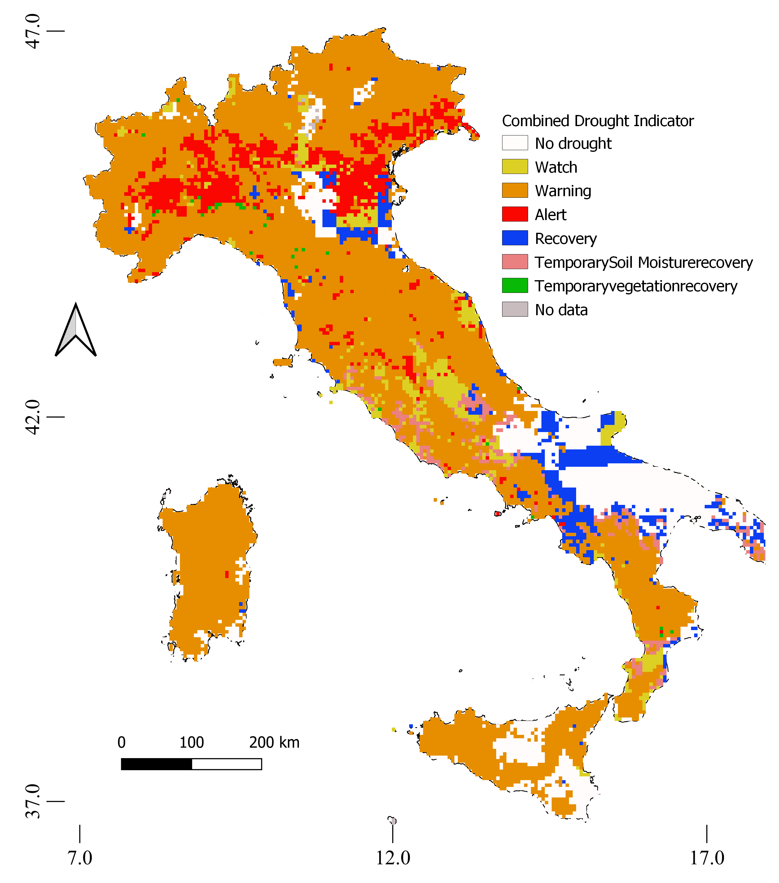
Figure 2.
Histogram of frequency distribution of correlation values () at MPs [1].
Figure 2.
Histogram of frequency distribution of correlation values () at MPs [1].
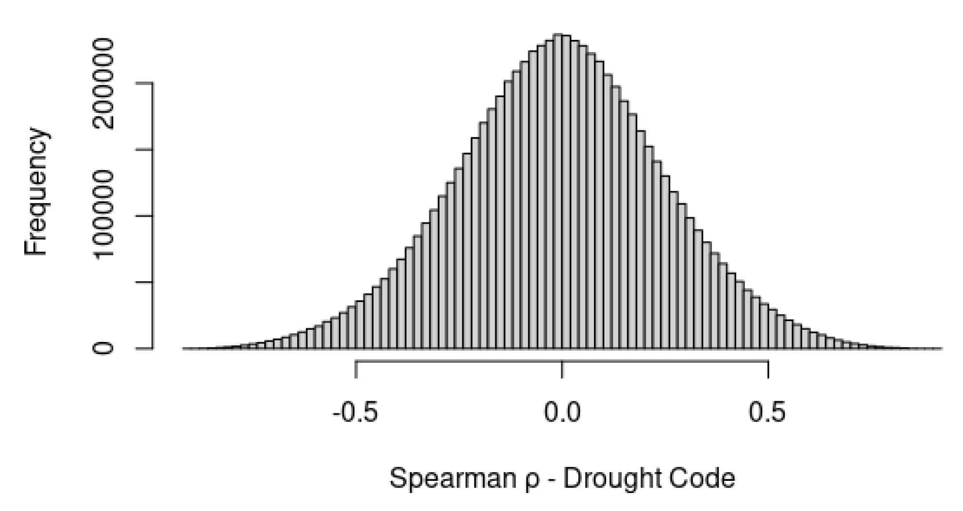
Figure 3.
Lag-time distribution of best correlations between and SVGM [1].
Figure 3.
Lag-time distribution of best correlations between and SVGM [1].
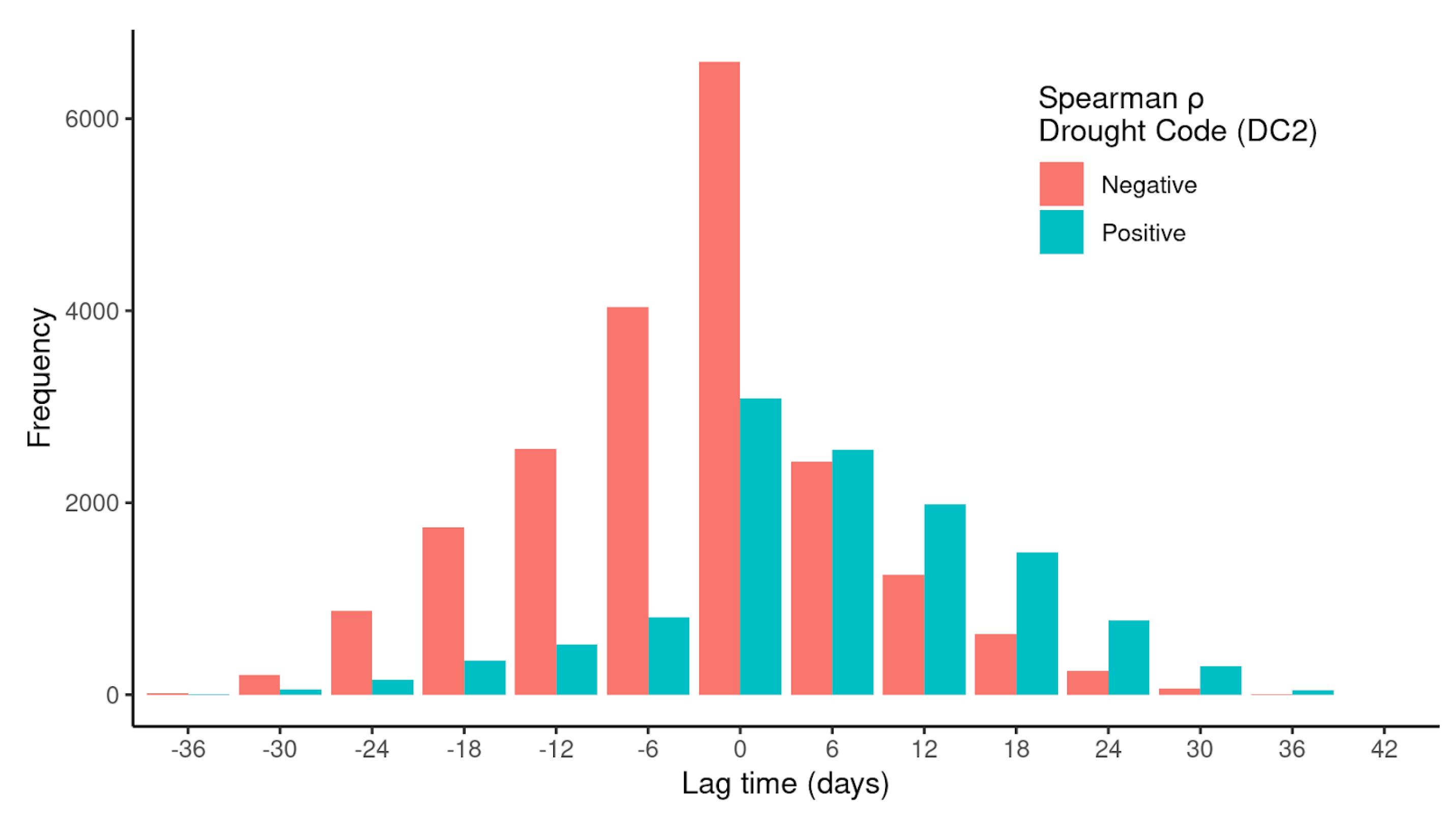
Figure 4.
Lag-time distribution of best correlations between temperature derived from calibrated MODIS and SVGM [1].
Figure 4.
Lag-time distribution of best correlations between temperature derived from calibrated MODIS and SVGM [1].
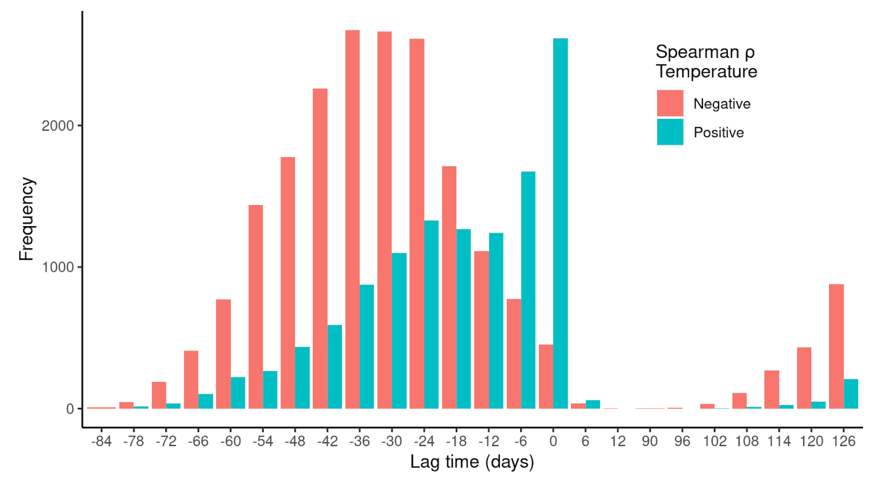
Figure 5.
(a) shows pairwise - values of correlations with ground motion; (b) shows temperature vs correlation. Top and bottom rows are negative and positive () values from testing correlation with SVGM [1].
Figure 5.
(a) shows pairwise - values of correlations with ground motion; (b) shows temperature vs correlation. Top and bottom rows are negative and positive () values from testing correlation with SVGM [1].
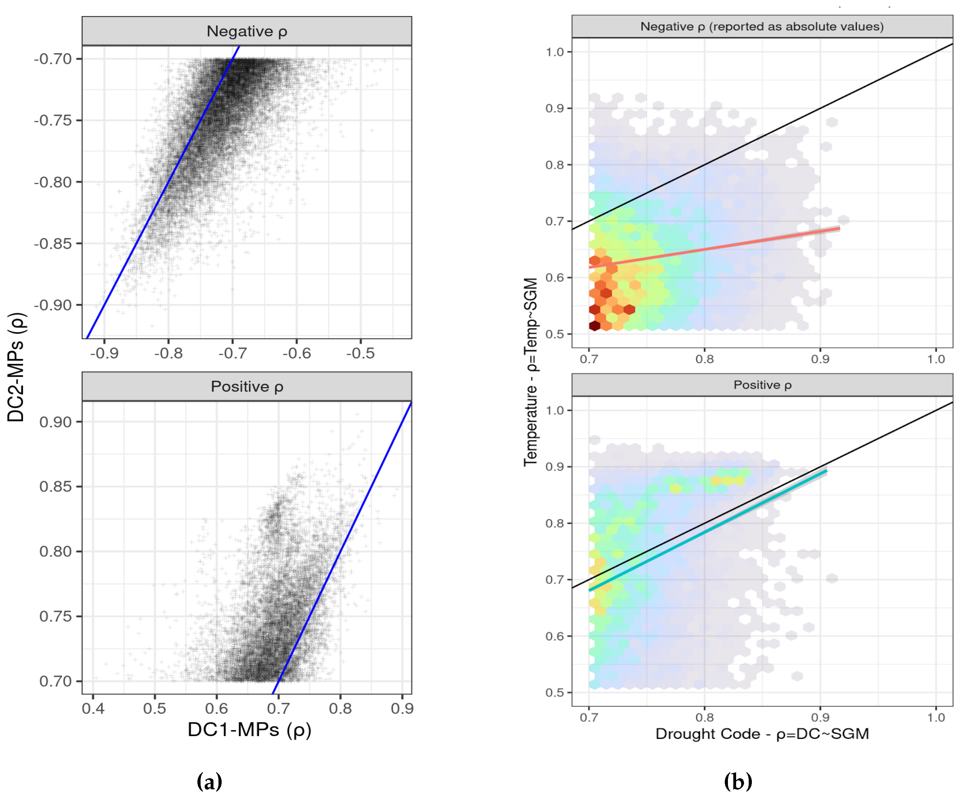
Figure 6.
Top row shows the spatial distribution of negative and positive correlations (left and right) in terms of percentage of correlated MPs with respect to the total number of MPs recorded by the European Ground Motion Service. The percentage was calculated over a regular hexagon grid overlayed to the study area. Bottom row pinpoints areas with highest percentage of correlated MPs, negative (bottom-left) and positive (bottom-right).
Figure 6.
Top row shows the spatial distribution of negative and positive correlations (left and right) in terms of percentage of correlated MPs with respect to the total number of MPs recorded by the European Ground Motion Service. The percentage was calculated over a regular hexagon grid overlayed to the study area. Bottom row pinpoints areas with highest percentage of correlated MPs, negative (bottom-left) and positive (bottom-right).
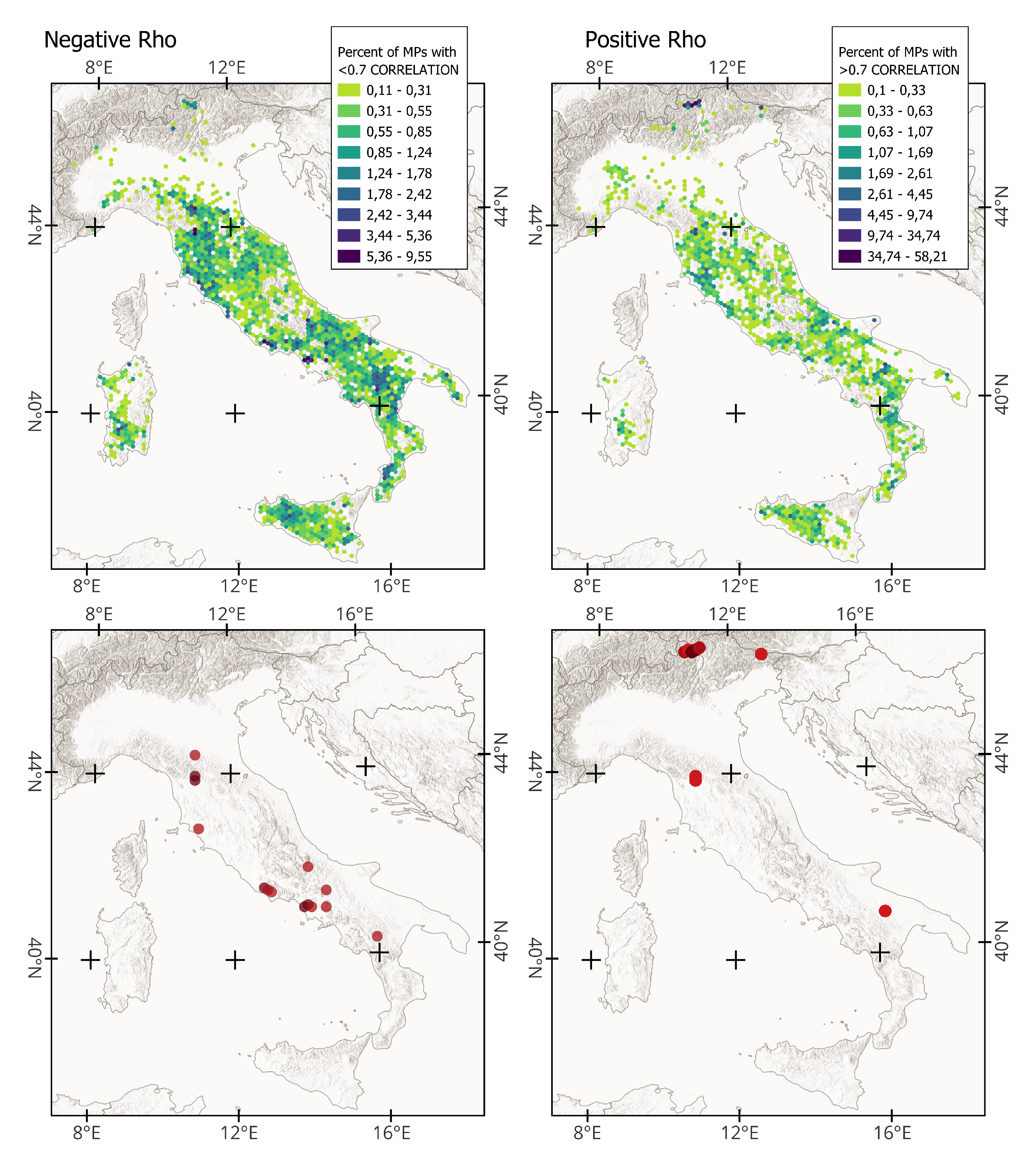
Figure 7.
Measurement Points with positive (a, b) and negative (c, d) Spearman correlation values.
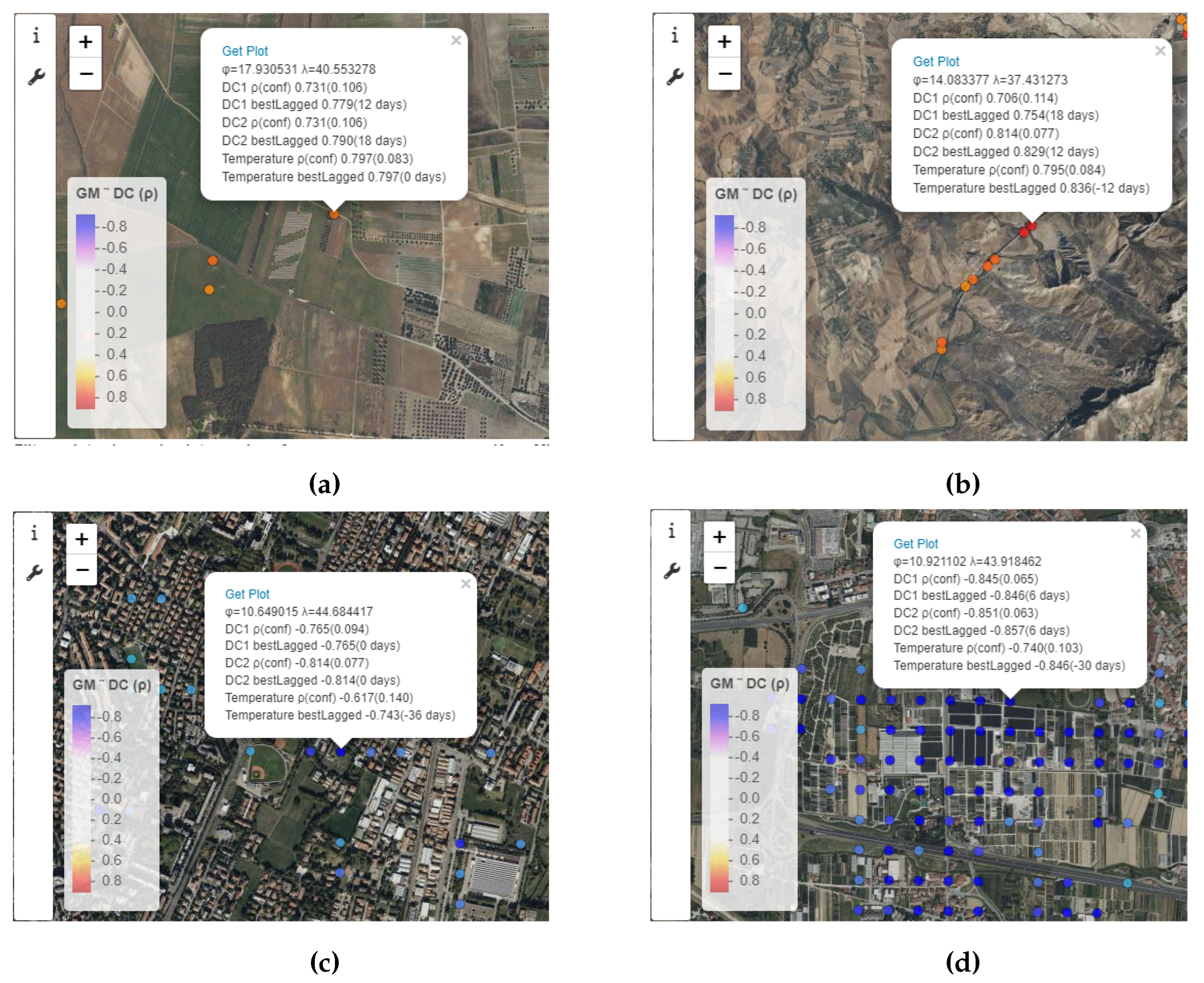
Figure 8.
Time-series plot showing the correlations at the respective Measurement Points in Figure 7.
Figure 8.
Time-series plot showing the correlations at the respective Measurement Points in Figure 7.
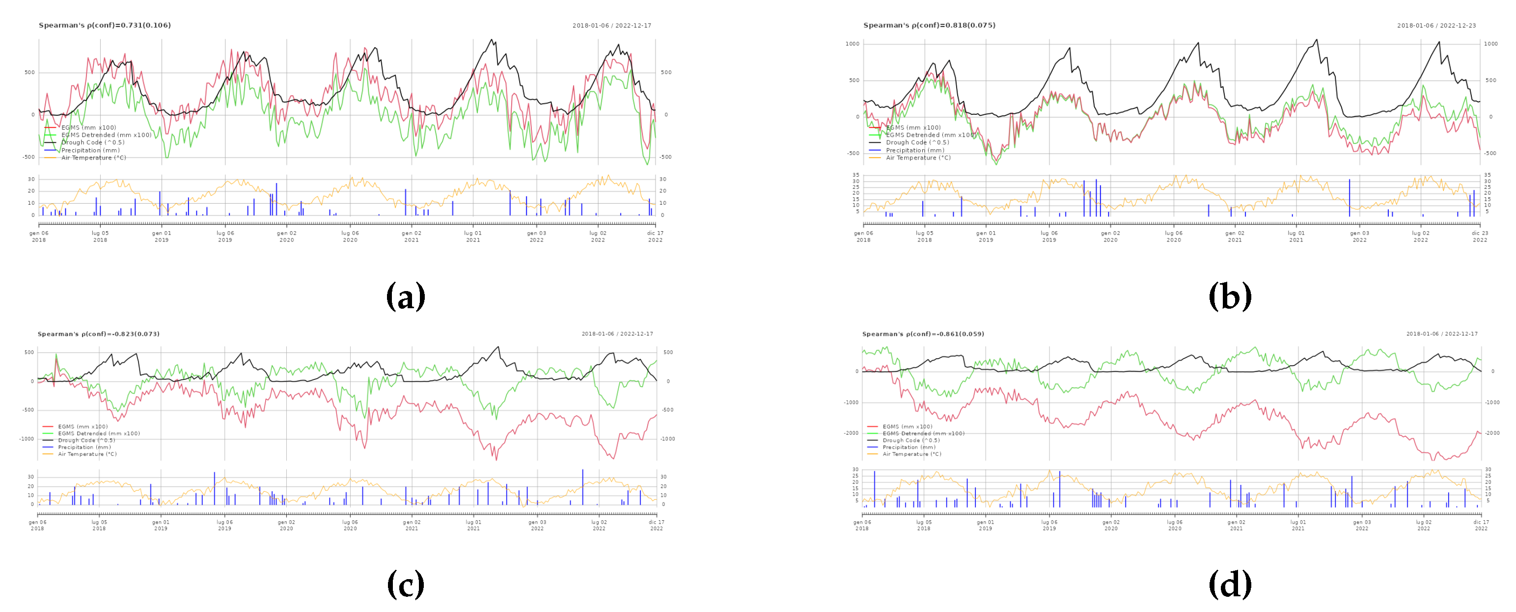
Figure 9.
“Viadotto Gorsexio” with a central pillar taller than 172 m.
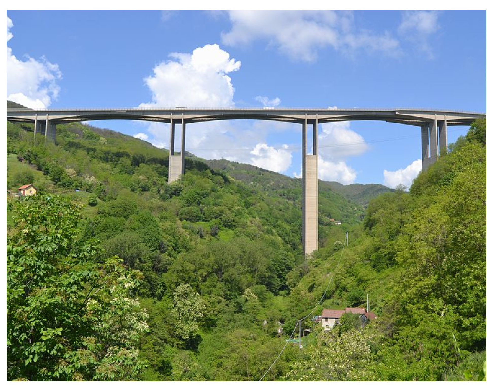
Figure 10.
Display of the Attribute information of the bridge on the WebGIS viewer (a) and a time series plot of the corresponding correlation (b).
Figure 10.
Display of the Attribute information of the bridge on the WebGIS viewer (a) and a time series plot of the corresponding correlation (b).
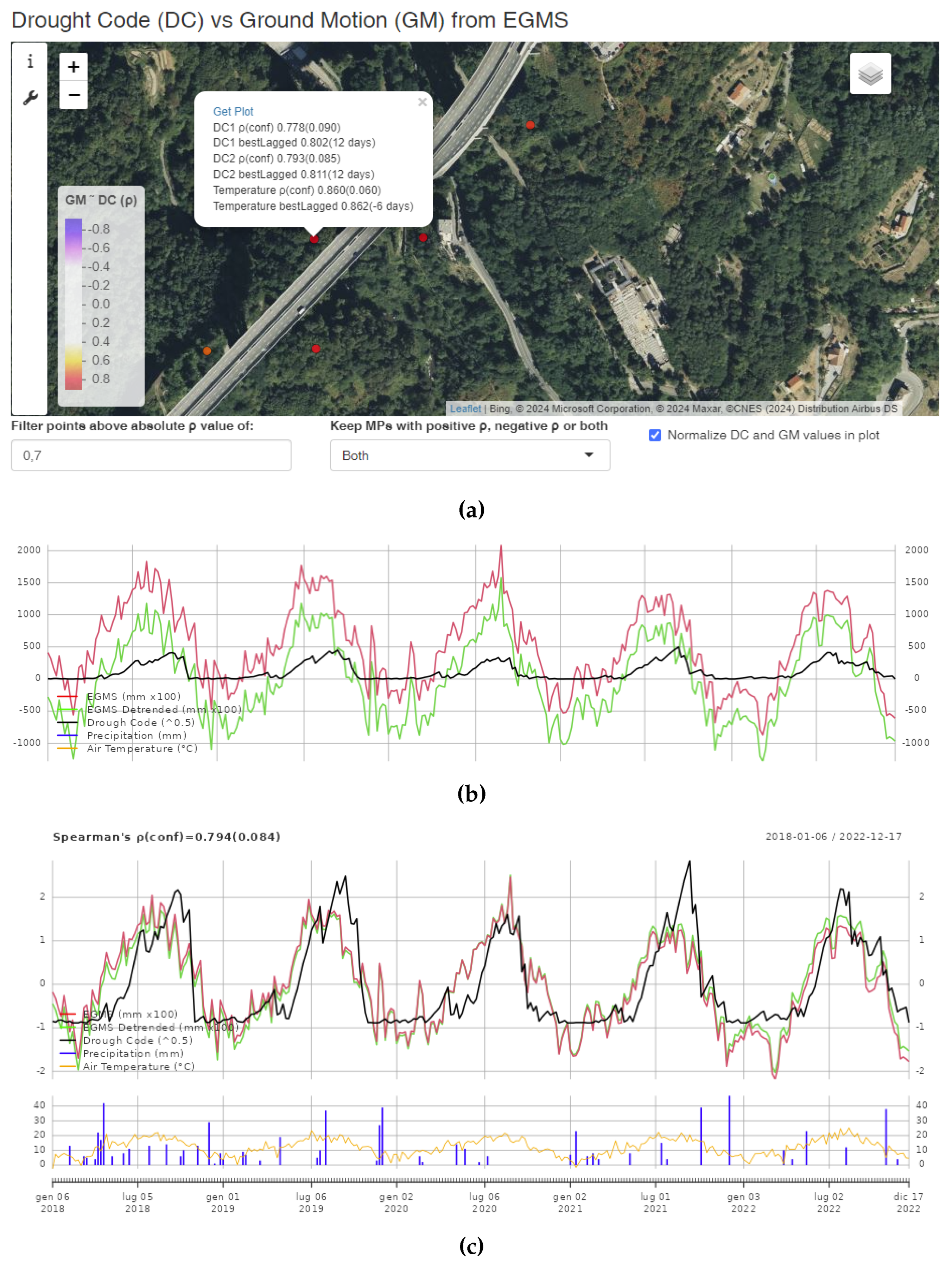

Table 1.
Data Sources.
| Source | Original data | Resolution | Reference |
|---|---|---|---|
| EGMS | Sentinel-1 | 100 m | [15] |
| MODIS product | MODIS Terra/Acqua | 1000 m | [16] |
| CHIRP | Interpolation of precipitation stations | 5566 m | [17] |
| CEMS Drought Code | Copernicus Service catalogue | x | [18] |
Table 2.
Number of MPs with strong correlation between SVGM and climate variables considered.
| Climatic factor | Positive | Negative | Total |
|---|---|---|---|
| 5868 | 13511 | 19379 | |
| 220 | 1529 | 1749 | |
| 12142 | 20684 | 32826 | |
| 1275 | 2594 | 3869 | |
| 6819 | 3538 | 10357 | |
| 3727 | 548 | 4275 |
Disclaimer/Publisher’s Note: The statements, opinions and data contained in all publications are solely those of the individual author(s) and contributor(s) and not of MDPI and/or the editor(s). MDPI and/or the editor(s) disclaim responsibility for any injury to people or property resulting from any ideas, methods, instructions or products referred to in the content. |
© 2024 by the authors. Licensee MDPI, Basel, Switzerland. This article is an open access article distributed under the terms and conditions of the Creative Commons Attribution (CC BY) license (http://creativecommons.org/licenses/by/4.0/).
Copyright: This open access article is published under a Creative Commons CC BY 4.0 license, which permit the free download, distribution, and reuse, provided that the author and preprint are cited in any reuse.