Submitted:
04 September 2024
Posted:
05 September 2024
You are already at the latest version
Abstract
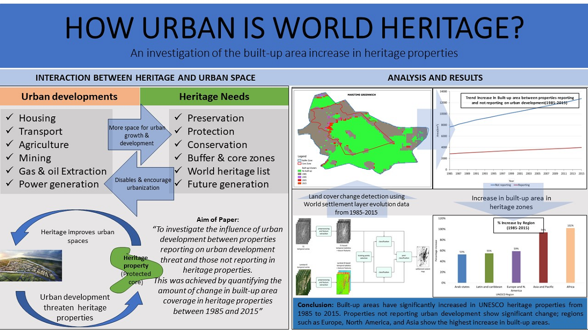
As urbanization continues to increase, key conservation areas like World Heritage sites are being altered. This transformation is a cause for concern as it threatens the Outstanding Universal Value of these sites. To address this issue, a research question was formulated: How urban is World Heritage? The research focused on identifying and monitoring urbanization in heritage core zones listed on the World Heritage by tracking changes in built-up areas from 1985 to 2015. The findings revealed that urban developments, including housing, transport infrastructure construction, visitor accommodation facilities, and land conversions, have significantly impacted heritage properties. More than a third (37\%, 426) of the cultural heritage properties reported urban development, with the highest occurrences in Europe, North America, Asia, and the Pacific. Furthermore, these regions also displayed the highest rate of change per year between 1985 and 2015. This indicates the urgent need to identify and monitor the urbanization of World Heritage to preserve their OUV amidst increasing urban development.
Keywords:
World Heritage
; urban built-up
; World Settlement Footprint Ev
; land-cover
; UNESCO
1. Introduction
Urbanization has triggered the rapid change of landscapes, altering land cover and land-use type. For example, urban sprawl competes with areas that act as carbon sinks and agricultural spaces [1] while compact urbanization leads to the densification and consolidation of detached urban spaces [2]. In some cities such as Abuja and Mumbai, the challenges of rapid urbanization in the last decade led to an uncontrolled expansion of cities and subsequently to the shrinking of conservation areas, listed as heritage [1,3,4].
The active role of urbanization in the decline of values and integrity of cultural heritage properties is acknowledged internationally [5]. Urbanization is a dynamic phenomenon that crosses multiple dimensions, such as social, economic, political, and physical, and can rapidly transform many aspects of cities and landscapes. As the demand from various stakeholders for land, accommodation, water, and tourism, among others, continues to increase, the pressure that this has on the landscape of WH can not be ignored [6,7]. UN-Habitat and World Bank predictions suggest that the rate of urbanization is expected to increase. Thus, as landscapes are expected to change, assessing how urban developments have been and will be influencing WH is significant, as these properties should be conserved.
In terms of the ongoing and expected rapid urbanization, which is reflected through physical urban Development, How Urban is World Heritage? is an important question to explore [8,9]. Urbanization activities such as constructing more buildings, transportation infrastructure, and environmental pollution threaten the conservation of cultural heritage properties, leading to the potential loss or degradation of buildings with cultural significance [5]. Moreover, there is very limited research on urban heritage at the global level [10,11], nor is there an analysis of spatial-temporal changes in heritage properties. Urban heritage studies today focusing on the urbanization of heritage properties generally focus on specific case studies[12,13,14,15,16]. Several studies aiming at quantifying change in WH properties that use land cover and land use change (LULC) as one of the main indicators are primarily found in natural heritage and focus on isolated heritage properties [14,15,17,18].
In China, quantification of land cover change detection in heritage properties using Very High-resolution images revealed significant impacts of urbanization [14]. A similar approach in India revealed that land cover change detection caused by deforestation and intensive sandstone mining negatively impacted unique cultural heritage properties [13]. An analysis of land cover and land use change in Cairo, Egypt, revealed both gains and losses of natural resources due to factors such as population growth and land value [15]. Meanwhile, a study on the Theban Temples of West Luxor assessed the impact of uncontrolled urban sprawl on heritage property. This investigation utilized multi-temporal and multi-sensor satellite data from Corona, Landsat, Spot, Quickbird, and Sentinel2A, along with spatial analysis. According to the study, the urban area of the heritage site expanded by between 1967 and 2017. Additionally, the investigation found that the rapid urban expansion led to poor sewage networks and high groundwater levels that had a negative impact on archaeological areas. As a result, the groundwater depth was altered [19].
A study in Angkor using GIS models revealed a 160% increase in urban development within 13 years in the city, which is partly listed in the World Heritage (WL) List. The GIS and remote sensing prediction model indicated that urbanization would destroy 19 monuments by 2030, compared to the seven monuments that were destroyed in 2017 [8].
Several studies have employed GIS and remote sensing data to evaluate the growth of urban areas in World Heritage properties. One example is using the Global Human Settlement layer, Global population grid products, and Global Night-time Light Images to develop the Urbanization Intensity Index, which measures and monitors the degree of urbanization in WH properties across China. The index indicates an increase in the degree of urbanization from 0.35 in 2000 to 0.45 in 2015, reflecting an increase in the built-up area of the 10 WH properties[9].
Land cover change detection from remotely sensed data has proven immensely useful in heritage studies. For instance, land-cover data, DEM, and Remote sensing data can be combined to assess the risk of natural and human distance on World Heritage sites. For example, in China, a study of Mount Emei using land-cover data, DEM, and Remote sensing revealed that the spatial distribution of disturbance is relatively small and that natural disasters presented a significant risk than human disturbance [17]. Additionally, combining user-contributed geospatial data to evaluate why specific heritage locations are more popular than others and what makes them attractive for tourism contributes to various approaches in investigating World Heritage sites. This realization highlights the importance of geospatial data sets and tools in heritage studies [16,20].
Additionally, some preliminary work has been devoted to creating and evaluating geospatial heritage data. For example, Protected Urban Planet, a tool available to the public, used a multisource data approach that integrates spatial data, descriptive information, and imagery to create public awareness in the monitoring of conservation areas inscribed as WH [21]. The UNESCO WH list is the most common data source for WH properties. The list provides several attributes of the WH properties, including their location in longitude and latitude data formats and years of inscription, among others [22]. Multiple studies have been conducted on the WH list supporting its creation and maintenance [23].
Finally, initiatives such as Prothego, Protected Planet, WH Outlook, Protected Urban Planet, and REScult are essential for managing WH properties [24]. However, difficulties arise when using these data sources to analyze the WH list because the initiatives are fragmented and not standardized. Additionally, the quality of the data sets and the lack of standard web semantics on the search interfaces disables its further integration and open access by future researchers, which further limits the quantification of the changes in heritage properties[25].
Land cover changes and patterns can be quantified to guide planning and preservation efforts for heritage sites [12]. This study examined the impact of urbanization on the physical development of designated World Heritage (WH) sites between 1985 and 2015. With a larger sample size than previous studies, this research shows how a spatiotemporal analysis using data from multiple sources can measure the evolution of WH sites on a global scale while also providing insight into the effect of urban development on these properties.
2. Materials and Methods
This research used a multisource data approach, linking three datasets:
- UNESCO’s WH list for the cultural heritage property names and other data such as year of inscription and location,
- The International Center for Space Technology on Natural and Cultural Heritage (HIST) for GIS data of the area extents of the heritage properties[13],
- German Aerospace Center (DLR) for Remote Sensing data and the spatiotemporal analysis of the World Settlement Footprint layer at 30m resolution from 1985 to 2015[1].
The study utilized a combination of qualitative, GIS and remote sensing approaches, as shown in Figure 1. QGIS was the primary platform for integrating and processing shapefile data, while Python and spreadsheets were used to prepare data and assess quality. Specifically, a spatial-temporal analysis [26,27,28,29,30,31,32] was employed to analyze the change in built-up area over time and to track the impact of urbanization on land-cover and land-use. This approach is commonly used in heritage studies to reveal the transformation of conservation areas, but typically at the level of a single WH property [14,33,34,35].
2.1. Step 1: State of Conservation-Urban Development
The initial step was to distinguish WH properties, i.e., Properties reporting and properties not reporting on urban development. Reporting properties are those that have been identified in the UNESCO State of Conservation (SoC), where the state party has identified one or more urban developments as posing a threat to the conservation areas. Non-reporting properties are those that have not documented any urban development affecting heritage properties [36]. This step was accomplished using the SoC information system [37,38]. State parties in the state of conservation reports identified twenty-two (22) forms of urban development. These search phrases were used as a search criterion in the inclusion and exclusion criteria (see Table 1). Furthermore, the properties were divided into the five UNESCO regions to facilitate data management and analysis and cross-regional analysis (see Figure 1).
The study area included cultural WH properties from all five UNESCO regions: Asia and the Pacific (APA), Latin and the Caribbean (LAC), Africa (AFR), Europe and North America (EUR), and the Arab States (ARB). Most WH properties do not report on urban development. In the AFR region, 12 out of 20 WH properties were reporting on urban development, while in the APA region, 34 out of 79 WH properties are reporting on urban development. On the other hand, in the ARB region, 15 out of 76 WH properties reported urban development. In the LAC region, 23 out of 44 WH properties were reporting on urban development In EUR, which had the highest number of properties reporting at 74 out of 291 WH properties (Figure 2).
2.2. Step 2: GIS-Heritage Properties Area Extent
This research analyzed the geographical information of 668 WH properties. These properties were matched to the results of the state of conservation report in Step 1. The matching process resulted in excluding properties that had no geographical information yet were reporting on urban development. The final result of this step was two categories of properties, all with available geographic information: those reporting on urban development and those not reporting on urban development and had matches in the 668 geodatabases. Properties that reported on urban development but did not have available geographic information were excluded from further analysis.
The geospatial data used in the research included the area extents of 668 WH properties (156 reporting urban development and 512 not reporting urban development). HIST created the area’s extent in a shapefile by digitizing heritage maps provided by different UNESCO state parties, accessible on the UNESCO website.
2.3. Step 3: RS-World Settlement Footprint Evolution
The raster data in question possesses a temporal resolution spanning from 1985 to 2015 and a spatial resolution of 30 meters. Its creation involved a sophisticated classification system that integrated open and free optical and radar satellite imagery by DLR and Google.
The WSF ev (World Settlement Footprint Evolution) was developed using an iterative approach. This was needed due to the absence of suitable archived high-resolution radar imagery. The method effectively delineated past settlement extents based solely on Landsat data acquired globally from late 1984 at a 30-meter resolution. In generating the layer, each pixel’s minimum, maximum, mean, and standard deviation of the normalized difference built-up index (NDBI) were extracted over time.
From 2015, with WSF2015 as a reference, an iterative extraction of settlement and non-settlement training samples occurred for each subsequent year. Notably, the layer assumes growth and does not account for instances of settlement shrinking. However, this is a relatively minor occurrence compared to the overarching global trend of urbanization, mainly localized in impact.
The implemented approach culminated in the creation of the WSF-Evolution data set. This data set outlines the global settlement extent at a 30-meter spatial resolution annually from 1985-2015 [39]. Validation of the raster data involved comparing it against 900,000 samples generated through crowd-sourcing and photo-interpretation of Very High-Resolution Google Earth imagery (VHR). For a more in-depth exploration of WSF ev, additional insights can be found in [1,40]. Because the non-built areas are not accounted for in the WSFev, with the accumulation of built-up area each year, the amount of built-up area in the heritage property was counted cumulatively starting with 1985. (See Figure 3.)
3. Results
3.1. State of the Conservation
The state of conservation suggests that 1/3(426) of the WH properties report urban development. The results show that regions such as Europe and North America have the highest documented number of properties reporting on urbanization (see Figure 3). Furthermore, the urban development that seems to be reported frequently by WH properties is housing within and between the regions. It was reported 215 times, i.e., LAC 33, APA 47, AFR 25, EUR 74, and ARB 36 times.
The second urban development frequently reported by properties was ground transport infrastructure, which was reported 140 times, i.e., LAC 22, APA 38, AFR 15, EUR 46, and ARB 19 times. The last reported urban development was nonrenewable energy, reporting seven times much in EUR and not affecting LAC and ARB (see Table 1).
3.2. Land Cover Change Detection
UNESCO recognizes the need to protect WH properties, often regulated by decreeing heritage zoning, core and buffer areas [41]. The delineation is intended to preserve heritage properties from unwanted urban threats that may affect the OUV of the heritage properties[13]. This means that monitoring the amount of transformation of heritage properties is essential. Over time, the amount of built-up in core zones indicates the transformation of WH properties. Thus, the amount of no built-up that changes into built-up can be understood as the amount of urban transformation that the core zone is experiencing [13]. This can be observed in properties reporting and those not reporting urban development within their core zones.
Figure 4 shows that the EUR region had the largest total built-up area, covering about 10473 km2, followed by LAC with 429 km2, APA with 837 km2, ARB with 1276 km2, and AFR with 60 km2. Additionally, between 1985 and 2015, there was a steady increase in the built-up area in all regions. The EUR region increased to 16696 km2, while APA increased to 2469 km2. ARB increased to 1276 km2, LAC to 665 km2, and AFR to 121 km2.
Furthermore, Figure 5 compares the percentage combined not reporting and reporting properties coverage area per region from 1985 to 2015. The figure indicates that the AFR region experienced a significant increase of approximately 102% in built-up areas between 1985 and 2015. This was followed by the APA region with a growth of 94%, EUR with 59%, LAC with 55%, and another region with 53%.
Figure 6 compares the properties reporting and not reporting on urban development between 1985 and 2015. The figure suggests that in 1985, properties not reporting on urban development had the highest total heritage coverage of 7649 km2, while properties reporting had 2824 km2. By 2015, properties not reporting experienced a 66% increase in a built-up area (12727 km2) which experienced a 44% increase (3969 km2). Thus, in 1985, the ratio of area coverage between properties not reporting to properties reporting was 1/4. In 2015, this ratio increased to 1/3, indicating a steady rise in urban built-up area in properties reporting on urban development.
Figure 7 shows the results of the relative comparison per region in heritage coverage for properties reporting and not reporting. Figure 7a shows that AFR experienced a significant increase in urban development in both categories. The properties not reporting on urban development had strong growth, from a 36km2 built-up area in 1985 to over 84km2 built-up area in 2015. On the other hand, the properties that reported on urban development in 1985 had just under 24km2 in 1985, which increased to just over 37km2 built-up area in 2015.
Figure 7b shows that APA also significantly increased in built-up areas during the period. For this region, there was an increase in a built-up area of 976km2 for properties not reporting on urban development, which was higher than the properties reporting 216km2 during the period. Specifically, the properties reporting on urban development changed from 338km2 to 554km2 built-up area between 1985-201. while the properties not reporting on urban development changed from 937km2 to over 1914km2 built-up area within the same period.
In the ARB region, it is also evident that both categories of properties that are not reported and those that are not reported on urban development display a steady increase in the built-up area. The amount of built-up area for properties not reporting at the start of 1985 was 764km2 built-up area to 1159km2 while those reporting it was below 73km2 to over 116km2 built-up area count between 1985-2015 (Figure 7c). During this period, the properties not reporting significantly increased the built-up area by 395km2 higher than those reporting, which increased by 43km2.
The EUR showed that properties not reporting on urban development changed the built-up area from below 5482km2 to 8904km2 between 1985 and 2015, while properties reporting on urban development had 2390km2 built-up area to 53261km2 within the same period Figure 7d). The increase in built-up area was significantly high for properties reporting, with a difference of 3421km2 for properties not reporting and 872km2 for properties reporting between 1985-2015.
Figure 7e shows the built-up changes in LAC for properties reporting and not reporting on urban development. Specifically, properties not reporting on urban development, which in 1985 had 429km2 of built-up area, experienced an increase to over 666km2 in 2015. this difference accounts for an increment of about 237km2 of the increased built-up area during the investigation period.
Figure 8 presents the average change in built-up area per year from 1985 to 2015 per region for properties reporting and not reporting on urban development. The figure highlights that both reporting and not reporting properties in EUR experienced significantly higher changes than in other regions. Not reporting properties showed a relatively larger increase of 287km2 per year, while reporting properties changed by 105km2 annually. Following this, APA regions experienced yearly changes of 61km2 for not reporting properties and 18km2 for properties reporting. Additionally, the ARB states recorded an average increase of 37km2 per year for properties not reporting and 3.8km2 for properties reporting. In regions such as LAC, where no properties were reporting on urban development, properties not reporting saw an average increase in the built-up area of 21km2 per year. The region of AFR displayed the smallest increase in built-up area, with properties reporting increasing the built-up area by 1.2 km2 and those not reporting by 2.7km2 annually during the assessment period.
4. Discussion
The interaction between urban space and heritage is complicated. Heritage properties can encourage urban development, but they should also be preserved to enhance urban areas [42]. It’s a challenge to manage heritage properties because urban needs like energy, housing, and recreational spaces often take priority and can overshadow the need to preserve history and culture. When urban needs are met in heritage properties, it can change them and make them lose their OUV. The aim of this article was to investigate the influence of urban development between properties reporting on urban development threats and those not reporting on heritage properties by quantifying the amount of change in built-up area coverage in heritage properties between 1985 and 2015.
The study results suggest that approximately one-third(426 out of the total) of the heritage properties report on urban development. Regions such as EUR have the highest documented number of properties reporting on urbanization, followed by APA. This finding aligns with the broader consensus because these regions have high urbanisation rates and increased urban development projects, such as housing, transport infrastructure, and Power network installation [43,44].
Several major urban developments pose a threat to the preservation of heritage sites. Housing is the most frequently mentioned urban development across different regions, especially in EUR and APA, followed by ground transport infrastructure. In EUR, non-renewable energy is also frequently cited as a threat to urban heritage properties. These urban developments are closely related to the demand for housing and the movement of people and goods. The increase in population and migration to urban areas has increased the demand for housing and transportation of goods and people. As authorities work to address housing and transportation challenges, compromises may be made regarding heritage properties [45].
Thus, monitoring land cover change in WH properties is crucial for protecting them from unwanted urban threats that could impact their OUV. The built-up area changes (1985-2015) highlight that the EUR region had the largest total built-up area, with a substantial increase by 2015. Followed by APA, while (LAC, ARB, and AFR) experienced the least change in the built-up area in 1985, with steady increases. Even though the AFR region has the least properties and heritage coverage by area relative to its initial heritage coverage, it has shown a significantly high change during this period. This can be attributed to the high urbanization rates in these regions, a trend predicted by organizations such as UN-Habitat [46,47].
The results suggest that more properties are not reporting urban threats but can be under urban development threats. From 1985 to 2015, they experienced significant built-up area increases compared to the properties reported in the state of conservation. The significance of reporting is to ensure that the properties recognise and identify the threats and subsequently find solutions to prevent further development. However, for various reasons beyond this article’s scope, it can be suggested that there is a reluctance by the state parties to report the threats to the heritage properties or not taking action on the threats [48,49]. On the other hand, properties that reporting on urban development displayed a reduced increase, suggesting that the reporting and protection of heritage properties may have some impact in disabling urbanisation of heritage coverage. However, this reduction was minimal considering that the nomination of properties to the World Heritage list suggests preserving, conserving and protecting heritage properties for now and future generations [50].
The findings suggest a substantial and ongoing trend of urbanization in WH properties, with variations across regions. The results indicate the challenges in conserving heritage properties in the face of urban development, especially in regions such as Europe and North America. Thus, the study emphasizes the importance of monitoring built-up changes, particularly in core zones, to understand and mitigate the impact on heritage properties [51].
Finally, further research is required in mapping the urbanisation of heritage properties. For instance, in this study, the date of inscription of the heritage properties were not considered in the built-up area change between 1985 and 2015. Thus, further investigation is required because we assume that the inscription date of the heritage property can influence the amount of built-up area and the magnitude of the change in heritage. Furthermore, these results can be used to assess the change of built-up area before and after the nomination and zoning of the heritage property. Furthermore, the built-up area was considered in for both the buffer and core zones of the heritage properties. However, a separate buffer and core zone assessment can reveal more detailed and specific results.
5. Conclusion
This research analyzed a global sample of WH properties to assess the change in land cover, with a focus on the amount of built-up area. These results of how the heritage properties have evolved in the temporal scale of analysis confirm several assumptions in individual properties that have been researched.
The data demonstrate significant regional disparities in the growth of built-up areas. The EUR region stands out with the highest initial and overall built-up area, indicating a higher level of urban development. In contrast, regions like AFR and APA had lower initial counts and slower growth, suggesting less urbanization and potentially more preservation of heritage properties.
The comparison between properties that report on urban development and those that do not report reveals exciting dynamics. Properties reporting on urban development tend to have a more controlled increase in built-up areas, possibly due to regulatory measures or a focus on preserving heritage. On the other hand, non-reporting properties often experience more substantial growth, which may pose challenges to maintaining heritage sites.
The average change per year highlights the intensity of urbanization. Even regions with lower overall growth, like AFR, can have more intense changes in specific regions, potentially affecting heritage properties. This underscores the importance of monitoring not just the quantity of growth but also the rate and location of changes in built-up areas.
Regions with rapid urbanization may face more significant challenges in preserving heritage properties. Strategies for managing this growth while safeguarding cultural heritage should be prioritized. Effective regulatory measures for urban development and around heritage sites are crucial. These regulations should consider the quantity and rate of change in built-up areas.
Ongoing monitoring and data analysis are essential for informed decision-making in heritage preservation. Understanding how urbanization trends impact specific regions and properties is vital for conservation efforts. Striking a balance between urban development and heritage preservation is a complex task. Decision-makers should consider the unique characteristics of each region and property when crafting conservation policies.
Analyzing built-up areas provides valuable insights into the challenges and opportunities for heritage property preservation in different regions. It emphasizes the need for data-driven, region-specific approaches to managing urban development while safeguarding cultural heritage.
Author Contributions
Conceptualization, Moses Katontoka, and Ana Pereira Roders; methodology, Moses Katontoka, Daniela Palacios-Lopez, and Esch Thomas; data curation, Chen Fulong, Moses Katontoka, and Esch Thomas; writing—original draft preparation, Moses Katontoka; writing—review and editing, Ana Pereira Roders, Nourian Pirouz and Francesca Noardo. All authors have read and agreed to the published version of the manuscript
Funding
The presented study is within the framework of the Heriland-Consortium. HERILAND is funded by the European Union’s Horizon 2020 research and innovation programme under the Marie Sklodowska-Curie grant agreement No. 813883.
Data Availability Statement
The project repository and datasets are available in https://github.com/mkvusa/How-urban-is-world-heritage-.git
Acknowledgments
This project collaborated with TU Delft, HIST and DLR to collect the shapefiles of WH properties and the spatial-temporal analysis of WH properties using the World Human Settlement layer evolution generated by these institutions by formal request. The copyright of shapefiles belongs to HIST, and the World Human Settlement Layer evolution belongs to DLR. We appreciate the constructive suggestions and comments from the anonymous reviewers and editors and the support from the Heriland team
Conflicts of Interest
The authors declare no conflicts of interest.
Abbreviations
The following abbreviations are used in this manuscript:
| UN | United Nations |
| LULC | Land-use and Land-cover |
| WH | World Heritage (List) |
| VHR | Very High Resolution |
| HIST | International Center for Space Technology |
| on natural and cultural Heritage | |
| DLR | Germany Aerospace Center |
| GIS | Geo-information systems |
| LAC | Latin America and the Caribbean |
| APA | Asia and the Pacific |
| EUR | Europe and North America |
| ARB | Arab States |
| AFR | Africa |
| SoC | State of Conservation |
| QGIS | Quantum Geographic Information Systems |
| Software | |
| WSF Ev | World Settlement Footprint Evolution |
| layer | |
| OUV | Outstanding Universal Value |
| UNESCO | United Nations Education, Science and |
| Cultural Organisation |
References
- Esch, T.; Asamer, H.; Bachofer, F.; Balhar, J.; Boettcher, M.; Boissier, E.; d’ Angelo, P.; Gevaert, C.M.; Hirner, A.; Jupova, K.; Kurz, F.; Kwarteng, A.Y.; Mathot, E.; Marconcini, M.; Marin, A.; Metz-Marconcini, A.; Pacini, F.; Paganini, M.; Permana, H.; Soukup, T.; Uereyen, S.; Small, C.; Svaton, V.; Zeidler, J.N. Digital world meets urban planet–new prospects for evidence-based urban studies arising from joint exploitation of big earth data, information technology and shared knowledge. International Journal of Digital Earth 2020, 13, 136–157, Publisher: Taylor & Francis. [Google Scholar] [CrossRef]
- Wilson, J.; Bayón, M. Concrete Jungle: The Planetary Urbanization of the Ecuadorian Amazon. Human Geography(United Kingdom) 2015, 8, 1–23. [Google Scholar] [CrossRef]
- Oriye, O. Urban expansion and urban land use in Ado Ekiti, Nigeria. American Journal of Research Communication 2013, 1. [Google Scholar]
- Moore, M.; Gould, P.; Keary, B.S. Global urbanization and impact on health. International journal of hygiene and environmental health 2003, 206, 269–278. [Google Scholar] [CrossRef]
- Fu, L.; Zhang, Q.; Tang, Y.; Pan, J.; Li, Q. Assessment of urbanization impact on cultural heritage based on a risk-based cumulative impact assessment method. Heritage Science 2023, 11, 177. [Google Scholar] [CrossRef]
- Kiruthiga, K.; Thirumaran, K. Effects of urbanization on historical heritage buildings in Kumbakonam, Tamilnadu, India. Frontiers of Architectural Research 2019, 8, 94–105, Publisher: Elsevier B.V.. [Google Scholar] [CrossRef]
- Chadee, S.; Stoute, V. Development of an urban intensity index to facilitate urban ecosystem studies in Trinidad and Tobago. Journal of Applied Statistics 2018, 45, 508–527. [Google Scholar] [CrossRef]
- Liu, J.; Ren, H.; Wang, X.; Shirazi, Z.; Quan, B. Measuring and predicting urban expansion in the Angkor region of Cambodia. Remote Sensing 2019, 11, 2064. [Google Scholar] [CrossRef]
- Li, Q.q.; Li, X.x.; Ma, Y.h.; Lu, L.l.; Wang, X.y.; Luo, L.; Cheng, Y.t.; Wu, R.c. Urbanization monitoring using big Earth Observation data for world heritage sites of China. IOP Conference Series: Earth and Environmental Science. IOP Publishing, 2020, Vol. 502, p. 012049.
- Guo, H.; Chen, F.; Tang, Y.; Ding, Y.; Chen, M.; Zhou, W.; Zhu, M.; Gao, S.; Yang, R.; Zheng, W.; others. Progress toward the sustainable development of world cultural heritage sites facing land-cover changes. The Innovation 2023, 4. [Google Scholar] [CrossRef]
- Chrastina, P.; Hronček, P.; Gregorová, B.; Žoncová, M. Land-use changes of historical rural landscape—Heritage, protection, and sustainable ecotourism: Case study of Slovak Exclave Čív (Piliscsév) in Komárom-Esztergom County (Hungary). Sustainability 2020, 12, 6048. [Google Scholar] [CrossRef]
- Chen, B.; Iannone III, B.V. FRAGSTATS: A Free Tool for Quantifying and Evaluating Spatial Patterns. EDIS 2020, 2020, 9–9, Publisher: University of Florida George A Smathers Libraries. [Google Scholar] [CrossRef]
- Tang, Y.; Chen, F.; Yang, W.; Ding, Y.; Wan, H.; Sun, Z.; Jing, L. Elaborate Monitoring of Land-Cover Changes in Cultural Landscapes at Heritage Sites Using Very High-Resolution Remote-Sensing Images. Sustainability (Switzerland) 2022, 14. [Google Scholar] [CrossRef]
- Banerjee, R.; Srivastava, P.K. Reconstruction of contested landscape: Detecting land cover transformation hosting cultural heritage sites from Central India using remote sensing. Land Use Policy 2013, 34, 193–203. [Google Scholar] [CrossRef]
- Salem, M.; Tsurusaki, N.; Divigalpitiya, P. Land use/land cover change detection and urban sprawl in the peri-urban area of greater Cairo since the Egyptian revolution of 2011. Journal of Land Use Science 2020, 15, 592–606. [Google Scholar] [CrossRef]
- Karayazi, S.S.; Dane, G.; Vries, B.d. Utilizing urban geospatial data to Understand heritage attractiveness in Amsterdam. ISPRS International Journal of Geo-Information 2021, 10, 198. [Google Scholar] [CrossRef]
- Huang, S.; Hu, Q.; Wang, S. A Risk Assessment Approach of World Heritage Sites Based on RS and GIS:—the cases studies of Mount Emei. 2021 28th International Conference on Geoinformatics; IEEE, 2021; pp. 1–4. [Google Scholar]
- Halim, M.K.; Ahmad, A.; Rahman, M.Z.; Amin, Z.M.; Khanan, M.F.; Musliman, I.A.; Kadir, W.H.; Jamal, M.H.; Maimunah, D.S.; Wahab, A.K.; Zabidi, M.M.; Suaib, N.M.; Zain, R.M. Land use/land cover mapping for conservation of UNESCO Global Geopark using object and pixel-based approaches. IOP Conference Series: Earth and Environmental Science 2018, 169. [Google Scholar] [CrossRef]
- Elfadaly, A.; Attia, W.; Qelichi, M.M.; Murgante, B.; Lasaponara, R. Management of cultural heritage sites using remote sensing indices and spatial analysis techniques. Surveys in Geophysics 2018, 39, 1347–1377. [Google Scholar] [CrossRef]
- Vileikis, O.; Escalante Carrillo, E.; Allayarov, S.; Feyzulayev, A. Documentation for preservation: Methodology and a GIS database of three World Heritage cities in Uzbekistan. ISPRS Annals of the Photogrammetry, Remote Sensing and Spatial Information Sciences. ISPRS 2017, 4, 311–318. [Google Scholar] [CrossRef]
- Verbruggen, R.; Pereira Roders, A.; Stash, N.; Leony, D.; Bra, P.D. Protected Urban Planet : Monitoring the Evolution of Protected Urban Areas Worldwide. ERSA 54th Congress Regional Development & Globalisation: Best practices, Saint Petersburg, Russia, August 26-29 2014. [Google Scholar]
- Valese, M.; Noardo, F.; Pereira Roders, A. World heritage mapping in a standard-based structured geographical information system. International Archives of the Photogrammetry, Remote Sensing and Spatial Information Sciences - ISPRS Archives 2020, 43, 81–88. [Google Scholar] [CrossRef]
- Rao, K. A new paradigm for the identification, nomination and inscription of properties on the World Heritage List. International Journal of Heritage Studies 2010, 16, 161–172. [Google Scholar] [CrossRef]
- Valese, M.; Noardo, F.; Pereira Roders, A. World heritage mapping in a standard-based structured geographical information system. International Archives of the Photogrammetry, Remote Sensing and Spatial Information Sciences - ISPRS Archives 2020, 43, 81–88. [Google Scholar] [CrossRef]
- Nishanbaev, I.; Champion, E.; McMeekin, D.A. A survey of geospatial semantic web for cultural heritage. Heritage 2019, 2, 1471–1498. [Google Scholar] [CrossRef]
- Tewabe, D.; Fentahun, T. Assessing land use and land cover change detection using remote sensing in the Lake Tana Basin, Northwest Ethiopia. Cogent Environmental Science 2020, 6, 1778998. [Google Scholar] [CrossRef]
- Campiani, A.; Lingle, A.; Lercari, N. Spatial analysis and heritage conservation: Leveraging 3-D data and GIS for monitoring earthen architecture. Journal of Cultural Heritage 2019, 39, 166–176. [Google Scholar] [CrossRef]
- Hao, S.; Zhu, F.; Cui, Y. Land use and land cover change detection and spatial distribution on the Tibetan Plateau. Scientific Reports 2021, 11, 1–13. [Google Scholar] [CrossRef]
- Das, S.; Angadi, D.P. Land use land cover change detection and monitoring of urban growth using remote sensing and GIS techniques: A micro-level study. GeoJournal 2022, 87, 2101–2123. [Google Scholar] [CrossRef]
- Zhu, Q.; Guo, X.; Deng, W.; Guan, Q.; Zhong, Y.; Zhang, L.; Li, D. Land-use/land-cover change detection based on a Siamese global learning framework for high spatial resolution remote sensing imagery. ISPRS Journal of Photogrammetry and Remote Sensing 2022, 184, 63–78. [Google Scholar] [CrossRef]
- Lv, Z.; Liu, T.; Benediktsson, J.A.; Falco, N. Land cover change detection techniques: Very-high-resolution optical images: A review. IEEE Geoscience and Remote Sensing Magazine 2021, 10, 44–63. [Google Scholar] [CrossRef]
- Lv, R.; Liu, Y.; Zhang, L.; Kong, D. Urban historic heritage buffer zone delineation: the case of Shedian. Heritage Science 2022, 10, 1–15. [Google Scholar] [CrossRef]
- Agapiou, A. UNESCO World Heritage properties in changing and dynamic environments: change detection methods using optical and radar satellite data. Heritage Science 2021, 9, 1–15. [Google Scholar] [CrossRef]
- Willis, K.S. Remote sensing change detection for ecological monitoring in United States protected areas. Biological Conservation 2015, 182, 233–242. [Google Scholar] [CrossRef]
- Zomer, R.J.; Ustin, S.L.; Carpenter, C.C. Land cover change along tropical and subtropical riparian corridors within the Makalu Barun National Park and Conservation Area, Nepal. Mountain Research and Development 2001, 21, 175–183. [Google Scholar] [CrossRef]
- Veillon, R.; others. State of conservation of world heritage properties. A statistical analysis (1979–2013), 2014.
- Bergesen, H.O.; Parmann, G.; Thommessen, Ø.B. Convention Concerning the Protection of the World Cultural and Natural Heritage (World Heritage Convention). In Yearbook of International Cooperation on Environment and Development 1998–99; Routledge, 2018; pp. 148–149. [Google Scholar]
- UNESCO. State of conservation information system, 2023.
- Marconcini, M.; Metz-Marconcini, A.; Esch, T.; Gorelick, N. Understanding current trends in global urbanisation-the world settlement footprint suite. GI_Forum 2021, 9, 33–38. [Google Scholar] [CrossRef]
- Marconcini, M.; Metz-Marconcini, A.; Üreyen, S.; Palacios-Lopez, D.; Hanke, W.; Bachofer, F.; Zeidler, J.; Esch, T.; Gorelick, N.; Kakarla, A.; Paganini, M.; Strano, E. Outlining where humans live, the World Settlement Footprint 2015. Scientific Data 2020, 7, 1–14. [Google Scholar] [CrossRef]
- Yastrebova, N.; Eterevskaya, I.; Stetsenko, S. Urban Zoning as a Method to Protection and Develop Historic Settlements (within the Volgograd Region). IOP Conference Series: Earth and Environmental Science. IOP Publishing, 2022, Vol. 988, p. 042075.
- Oevermann, H.; Mieg, H.A. Urban development planning and world cultural heritage: Two perspectives of planning practice dealing with industrial heritage. Planning Practice & Research 2021, 36, 430–441. [Google Scholar]
- Maciulyte-Sniukiene, A.; Butkus, M. Does infrastructure development contribute to EU countries’ economic growth? Sustainability 2022, 14, 5610. [Google Scholar] [CrossRef]
- Becker, W.; Domínguez-Torreiro, M.; Neves, A.R.; Moura, C.T.; Saisana, M. Exploring the link between Asia and Europe connectivity and sustainable development. Research in Globalization 2021, 3, 100045. [Google Scholar] [CrossRef]
- Yu, J.; Safarov, B.; Wang, C.; Buzrukova, M.; Janzakov, B. The Effect of Transportation Networks on Heritage Tourism and New Urbanization—Empirical Research Based on Rich Heritage Sites in a Chinese Province. Heritage 2023, 6, 7293–7315. [Google Scholar] [CrossRef]
- Un-Habitat. State of the World’s cities 2008/9: Harmonious Cities; Earthscan, 2008. [Google Scholar]
- Ekeocha, D.O. Urbanization, inequality, economic development and ecological footprint: Searching for turning points and regional homogeneity in Africa. Journal of Cleaner Production 2021, 291, 125244. [Google Scholar] [CrossRef]
- Brown, N.E.; Liuzza, C.; Meskell, L. The politics of peril: UNESCO’s list of world heritage in danger. Journal of Field Archaeology 2019, 44, 287–303. [Google Scholar] [CrossRef]
- Dumper, M.; Larkin, C. The politics of heritage and the limitations of international agency in contested cities: a study of the role of UNESCO in Jerusalem’s Old City. Review of International Studies 2012, 38, 25–52. [Google Scholar] [CrossRef]
- Otero, J. Heritage conservation future: where we stand, challenges ahead, and a paradigm shift. Global Challenges 2022, 6, 2100084. [Google Scholar] [CrossRef] [PubMed]
- Guzmán, P.; Pereira Roders, A.; Colenbrander, B. Bridging the gap between urban development and cultural heritage protection. IAIA14 Conference Proceedings; 2014. [Google Scholar]
Figure 1.
Conceptual workflow and method employed in the research
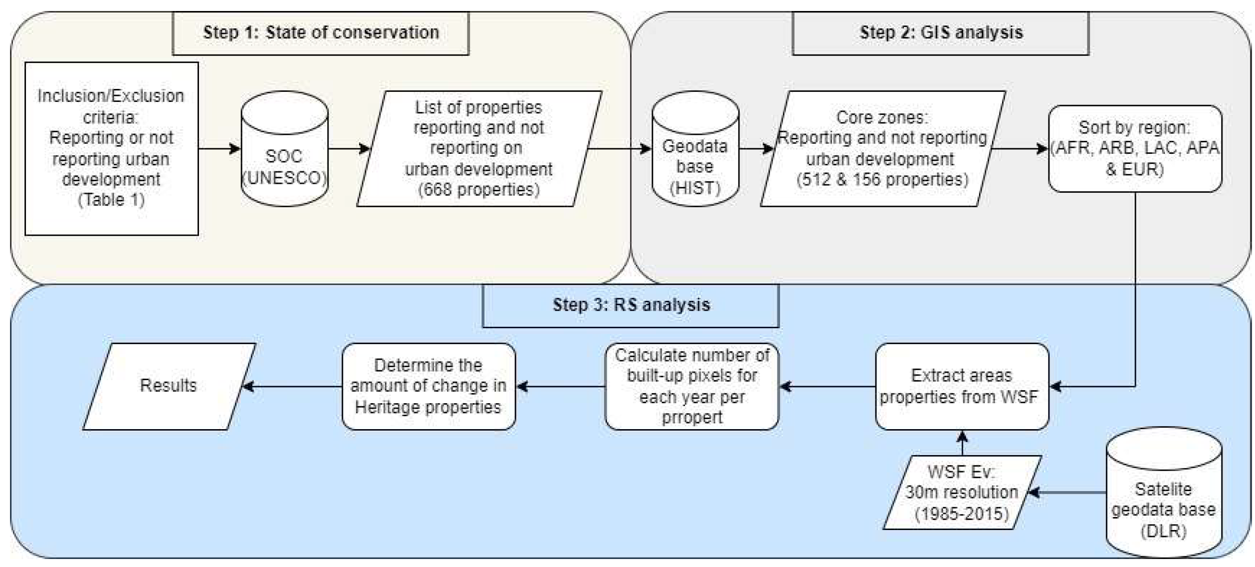
Figure 2.
UNESCO’s WH regions and the number of properties reporting and not reporting urban development in each region.
Figure 2.
UNESCO’s WH regions and the number of properties reporting and not reporting urban development in each region.
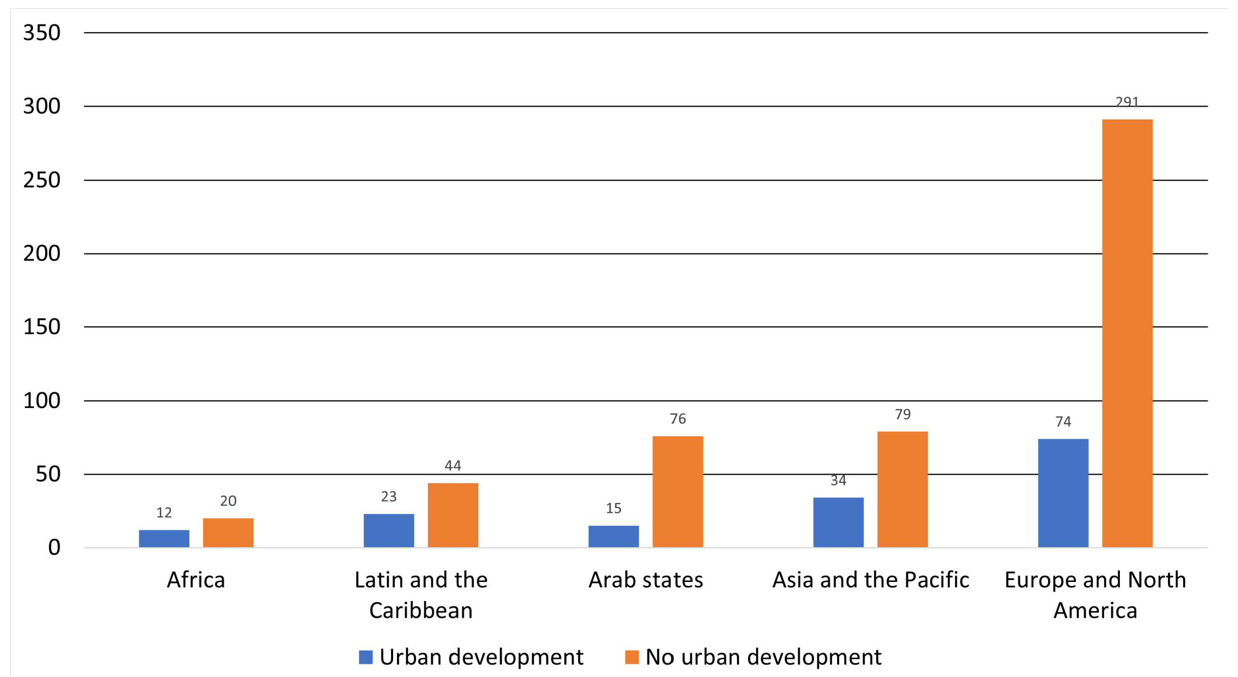
Figure 3.
Illustration of WSF ev from 1985-2015 using the heritage property Maritime Greenwich as an example
Figure 3.
Illustration of WSF ev from 1985-2015 using the heritage property Maritime Greenwich as an example
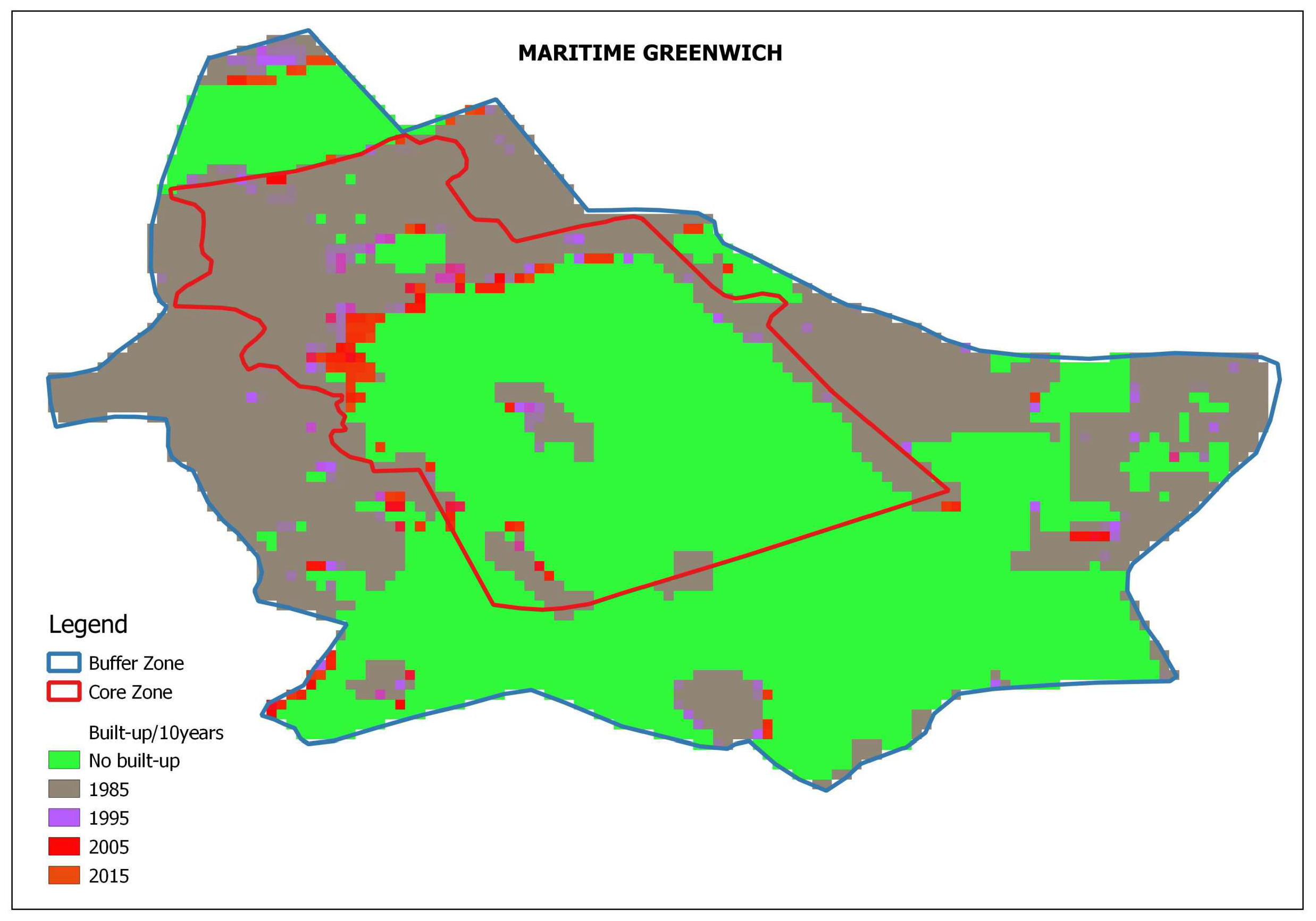
Figure 4.
Comparative overview of the change in total heritage built-up area in all UNESCO regions between 1985-2015.
Figure 4.
Comparative overview of the change in total heritage built-up area in all UNESCO regions between 1985-2015.
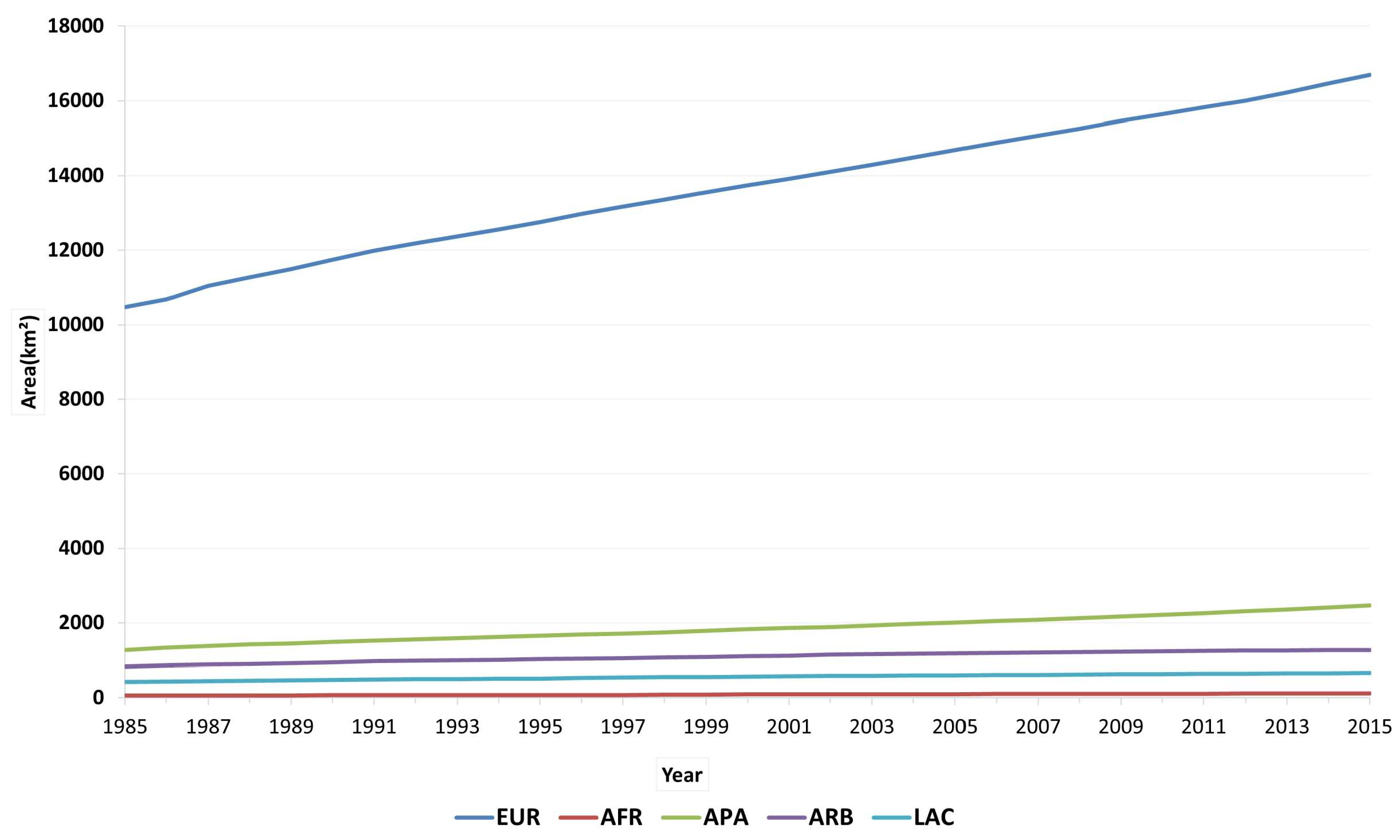
Figure 5.
The combined not reporting and reporting properties comparative regional percentage increase in a built-up area coverage from 1985-2015
Figure 5.
The combined not reporting and reporting properties comparative regional percentage increase in a built-up area coverage from 1985-2015
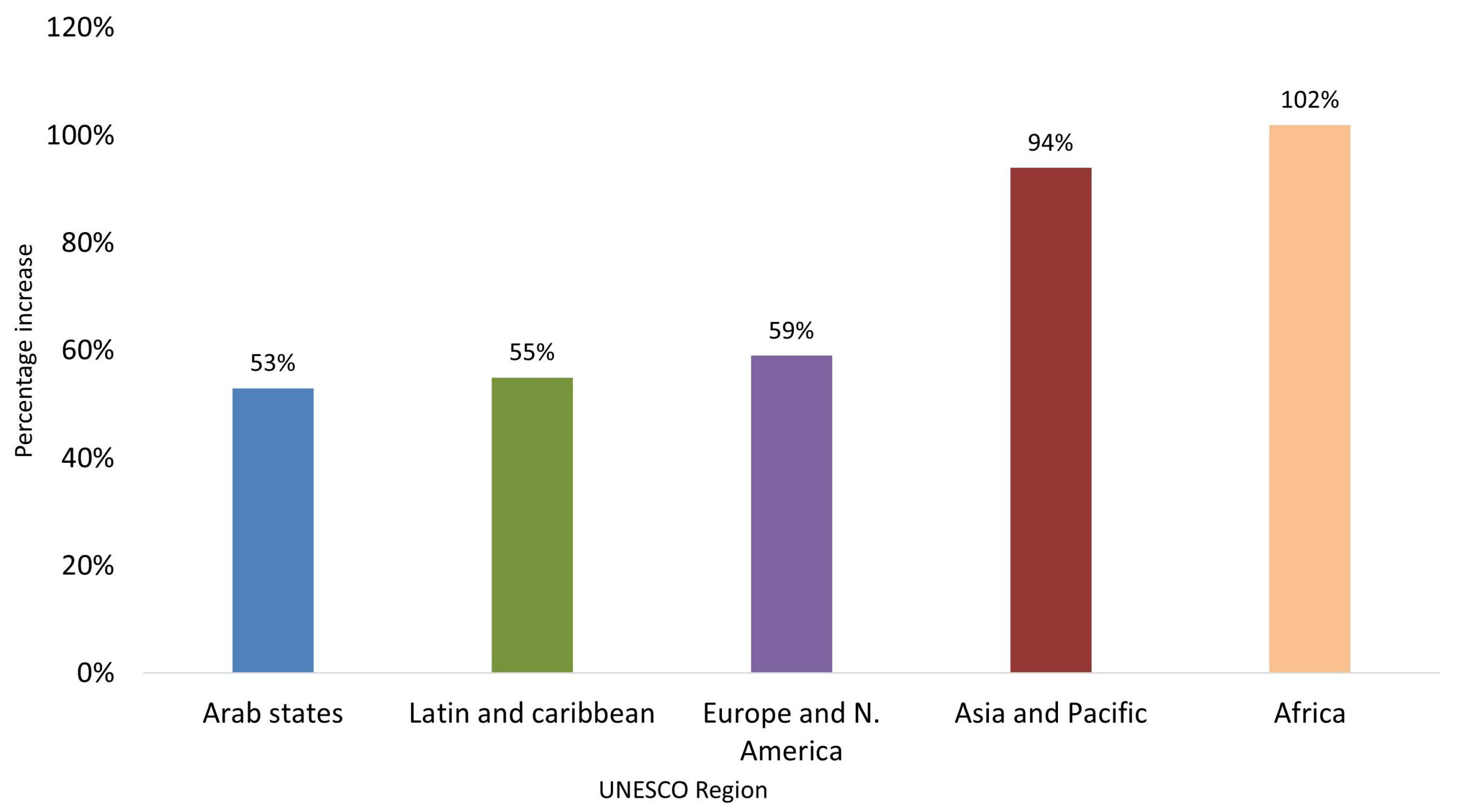
Figure 6.
Comparative overview of the built-up area increase in WH properties between properties reporting and not reporting urban development between 1985-2015
Figure 6.
Comparative overview of the built-up area increase in WH properties between properties reporting and not reporting urban development between 1985-2015
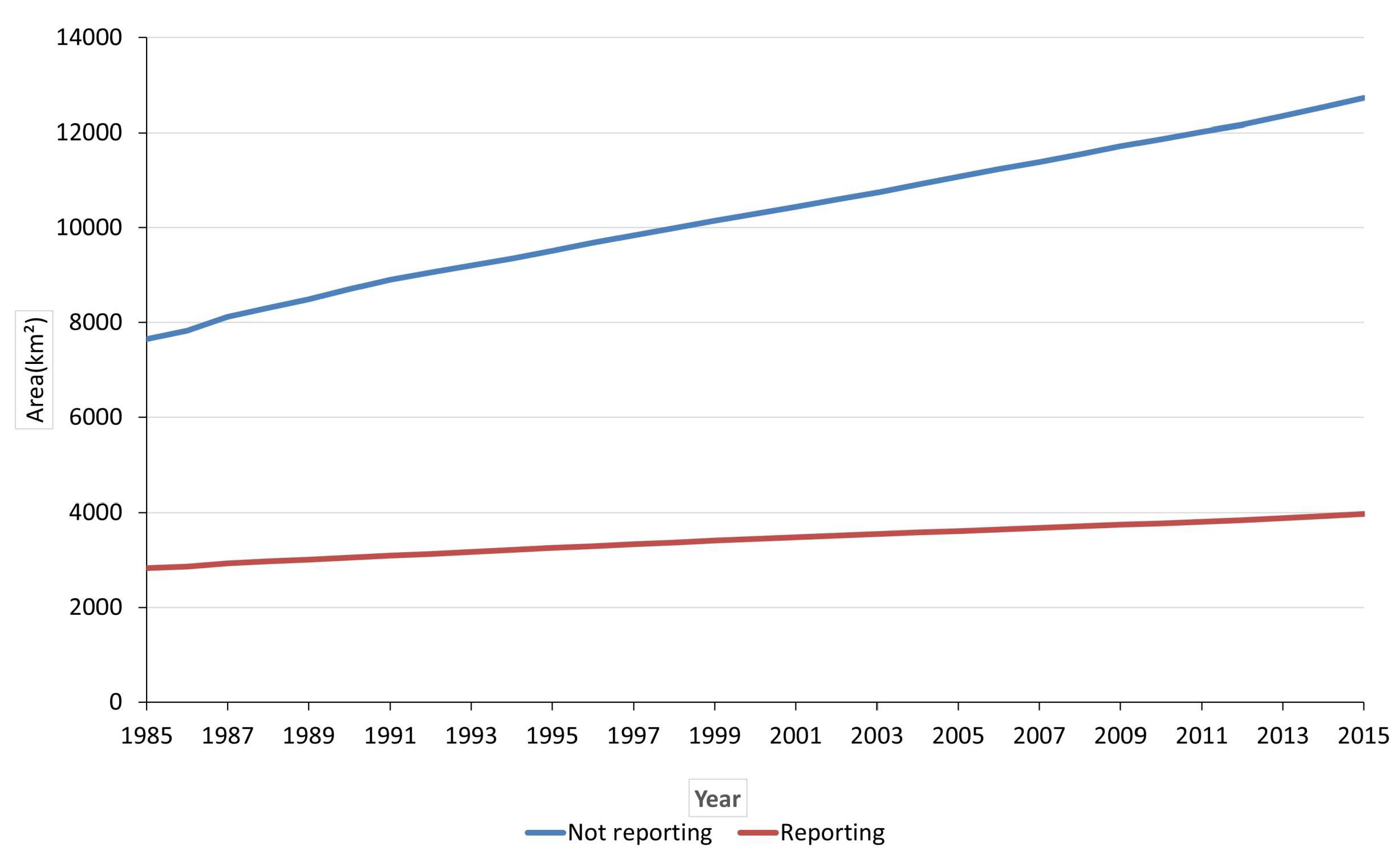
Figure 7.
Comparison in-built-up area change between not reporting and reporting properties per region (AFR, LAC, EUR, APA and ARB)
Figure 7.
Comparison in-built-up area change between not reporting and reporting properties per region (AFR, LAC, EUR, APA and ARB)
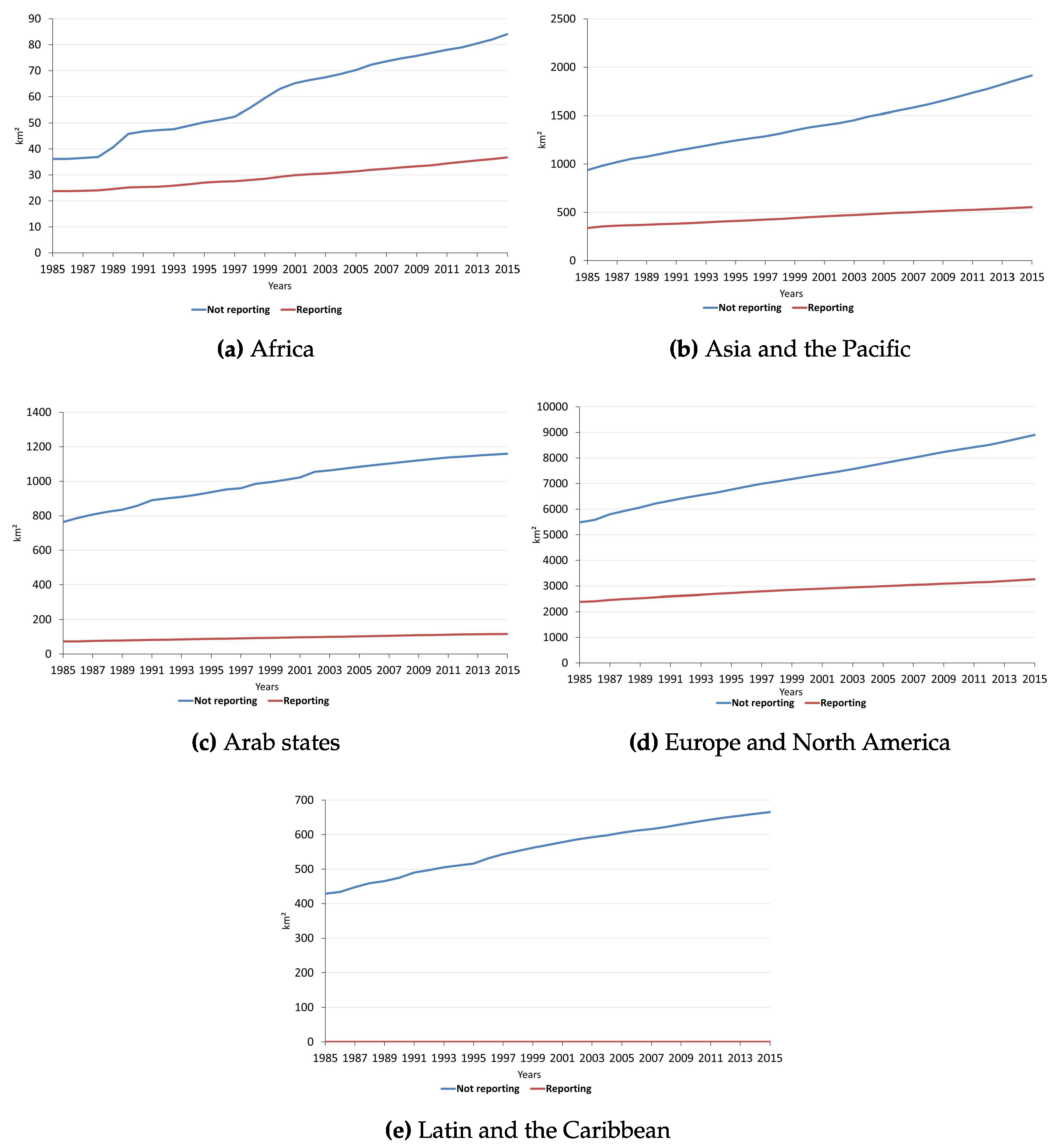
Figure 8.
Average built-up area increase per year between 1985-2015
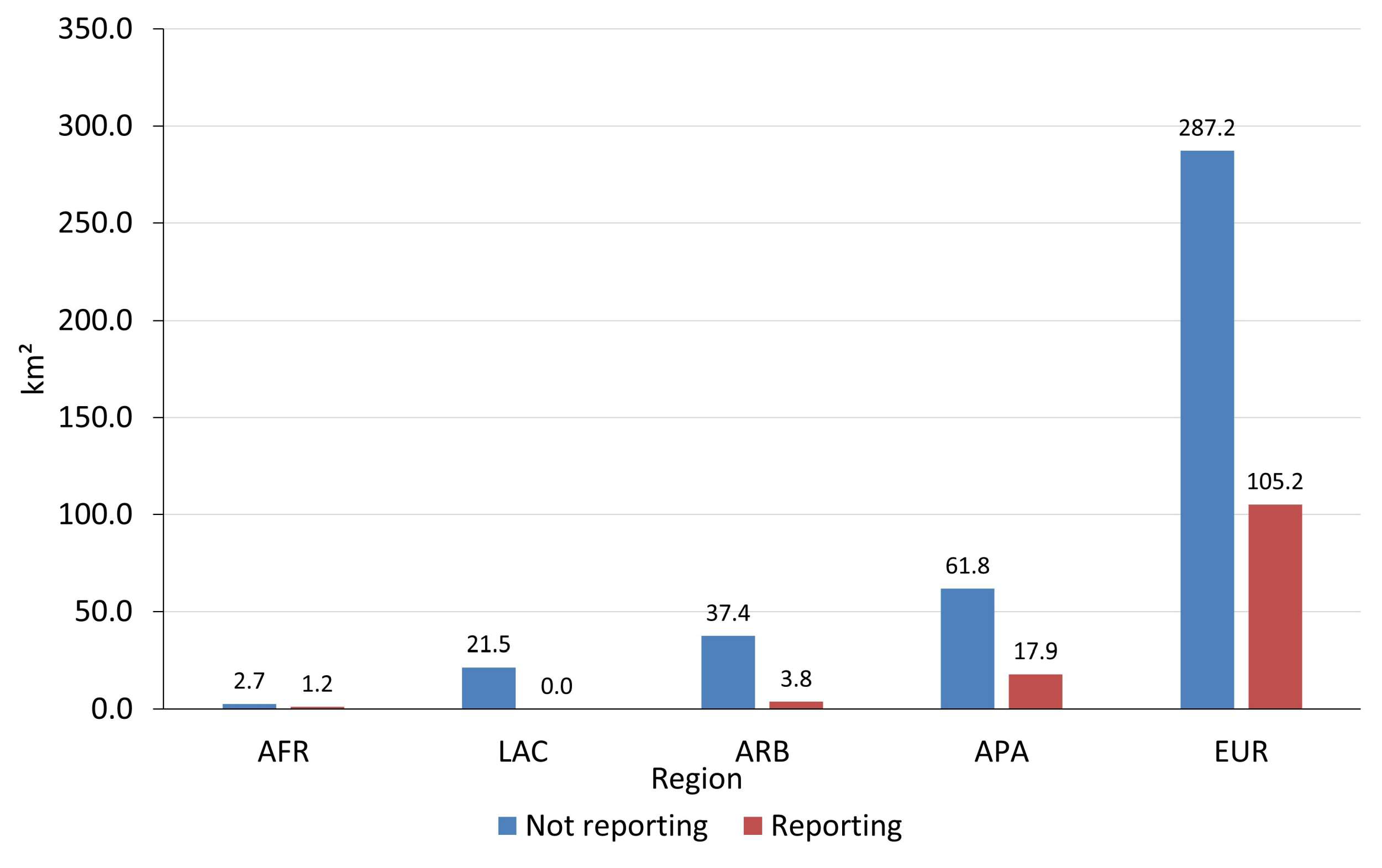

Table 1.
Shows the number of times the urban development was reported by properties in each region
| URBAN DEVELOPMENT | LAC | APA | AFR | EUR | ARB | TOTAL |
|---|---|---|---|---|---|---|
| 1. Housing | 33 | 47 | 25 | 74 | 36 | 215 |
| 2. Ground transport infrastructure | 22 | 38 | 15 | 46 | 19 | 140 |
| 3. Major visitor accommodation and | 15 | 16 | 14 | 29 | 11 | 85 |
| associated infrastructure | ||||||
| 4. Land conversion | 15 | 17 | 23 | 6 | 16 | 77 |
| 5. Interpretative and visitation facilities | 8 | 19 | 10 | 23 | 10 | 70 |
| 6. Mining | 8 | 16 | 20 | 18 | 1 | 63 |
| 7. Water infrastructure | 9 | 16 | 10 | 7 | 5 | 47 |
| 8. Commercial development | 9 | 18 | 3 | 11 | 5 | 46 |
| 9. Livestock, farming and grazing of | 11 | 5 | 19 | 5 | 5 | 45 |
| domesticated animal | ||||||
| 10. Oil and gas | 3 | 4 | 11 | 16 | 2 | 36 |
| 11. Localised utilities | 1 | 5 | 0 | 11 | 19 | 36 |
| 12. Forestry wood productions | 5 | 8 | 8 | 10 | 0 | 31 |
| 13. Major linear and utilities | 5 | 6 | 4 | 9 | 3 | 23 |
| 14. Crop production | 6 | 3 | 8 | 2 | 2 | 21 |
| 15. Marine transport infrastructure | 7 | 5 | 2 | 12 | 4 | 20 |
| 16. Water extraction | 1 | 5 | 3 | 7 | 1 | 17 |
| 17. Renewable energy facilities | 3 | 1 | 2 | 10 | 1 | 17 |
| 18. Air transport infrastructure | 3 | 5 | 3 | 5 | 0 | 16 |
| 19. Underground transport infrastructure | 5 | 4 | 0 | 4 | 2 | 15 |
| 20. Quarrying | 0 | 3 | 0 | 9 | 2 | 14 |
| 21. Industrial area | 2 | 4 | 3 | 2 | 0 | 11 |
| 22. Nonrenewable energy | 0 | 2 | 1 | 4 | 0 | 7 |
Disclaimer/Publisher’s Note: The statements, opinions and data contained in all publications are solely those of the individual author(s) and contributor(s) and not of MDPI and/or the editor(s). MDPI and/or the editor(s) disclaim responsibility for any injury to people or property resulting from any ideas, methods, instructions or products referred to in the content. |
© 2024 by the authors. Licensee MDPI, Basel, Switzerland. This article is an open access article distributed under the terms and conditions of the Creative Commons Attribution (CC BY) license (http://creativecommons.org/licenses/by/4.0/).
Copyright: This open access article is published under a Creative Commons CC BY 4.0 license, which permit the free download, distribution, and reuse, provided that the author and preprint are cited in any reuse.


