

Submitted:
27 August 2024
Posted:
27 August 2024
You are already at the latest version
Abstract
The Greater Amanzule Peatland (GAP) in Ghana represents an important ecosystem facing dynamic land cover changes as a result of both natural and anthropogenic factors. This study integrates multispectral and radar remote sensing data from Landsat-7 and -8, L-band SAR, and SRTM to conduct a machine learning-based analysis of these changes from 2010 to 2020 and to predict future scenarios up to 2040. Findings reveal a 12% expansion in peatland cover, equivalent to approximately 6,570 ± 308.59 hectares, despite declines in specific peatland types. Concurrently, anthropogenic land uses have increased, evidenced by an 85% rise in rubber plantations (from 30,530 ± 110.96 hectares to 56,617 ± 220.90 hectares) and a 6% reduction in natural forest cover (5,965 ± 353.72 hectares). Sparse vegetation, including smallholder farms, decreased by 35% from 45,064 ± 163.79 hectares to 29,424 ± 114.81 hectares. Projections for 2030 and 2040 indicate minimal changes based on current trends; however, these do not consider potential impacts from climate change, large-scale development projects, and demographic shifts, necessitating cautious interpretation. The results highlight areas of stability and vulnerability within the GAP and offer critical insights for the development of targeted conservation strategies. Additionally, the methodological framework presented provides a robust approach for accurate and detailed landscape-scale monitoring of tropical peatlands, applicable to other regions facing similar environmental challenges.
Keywords:
Land cover change
; Tropical peatlands
; Machine learning classification
; Environmental conservation
; Predictive modelling
1. Introduction
In an era characterised by the escalating ramifications of global climate change, including severe weather events and species extinction, the management of peatland emerges as a pivotal concern [1]. Peatlands are unique ecosystems formed in waterlogged environments where slow decomposition of plant material leads to the accumulation of peat, a dense organic matter [2]. Such accumulations, often extending over millennia, establish them as significant carbon sinks, playing an essential role in climate change mitigation efforts. Globally, they are estimated to hold 650 billion tonnes of carbon on 3% of the Earth’s land surface, the equivalent to more than half of the carbon in the atmosphere or the carbon stored by Earth’s vegetation [1]. They also provide a wide range of ecosystem services including improvement of water quality and runoff regulation, and the provision of a landscape with cultural, recreational and livelihood values [3,4,5].
Despite their importance, peatlands face significant threats from anthropogenic land-use changes, including logging, plantation development, urban and industrial expansion, and accidental burning [6,7,8]. These contribute to the destruction of approximately 500,000 hectares of peatlands annually [6]. The United Nations Environment Programme [6] reports that the current rate of loss and degradation of healthy peatland is ten times faster than the rate of expansion over the last 10,000 years. It is noted that around 12% of the estimated 500,000,000 ha of global peatlands are severely degraded to the extent that peat formation has ceased, leading to carbon stock losses [6]. Such land use modifications decrease biodiversity and transform peatlands into net sources of greenhouse gases (GHGs), accelerating carbon dioxide emissions from drained peat soils [5]. It also triggers a loss of hydrological integrity and peat subsidence, amplifying the risk of flooding and altering nutrient storage and cycling dynamics [9].
In Ghana, the Greater Amanzule peatlands (GAP) reflect these global trends, experiencing ecological pressures due to agricultural plantation development, urbanisation and the burgeoning oil and gas industries [10,11,12,13]. Since the onset of oil and gas activities in 2011, these pressures have intensified, threatening the peatland’s ecological health and resilience [11]. This underscores the urgent need for accurate land cover information and predictive modelling to support effective management and conservation strategies for tropical peatlands like the GAP.
Previous research has extensively covered land cover mapping and change detection in tropical peatlands. Various remote sensing techniques have been employed to monitor and analyse land cover changes over time, contributing to a better understanding of these ecosystems’ dynamics [14,15,16,17]. Remote sensing data has been utilised to classify land cover types, detect changes, and assess the impacts of human activities on peatland environments [18,19,20,21,22]. Despite these advancements, there remains a notable gap in the predictive modelling of future land cover scenarios, which is crucial for proactive environmental management. This study therefore employs an integrated geospatial approach that combines multi-source remote sensing data with advanced machine learning techniques to enhance the accuracy of land cover classification and provide robust predictions of future land use scenarios in the GAP. Specifically, this study (1) utilises combined optical, Synthetic Aperture Radar (SAR), and digital elevation data for tropical peatland mapping and change detection in the GAP, and (2) predicts future land cover scenarios up to 2040.
2. Methodology
2.1. Study Area
GAP is in the Western Region (WR) of Ghana (Figure 1a). WR is bordered to the west by Cote D’Ivoire, to the east by the Central Region, to the north by Ashanti and Western North regions, and to the south by the Gulf of Guinea (Figure 1a). The peatland lies within the Coastal savanna and Rain Forest zones of Ghana (Figure 1a) and traverses the four coastal districts of Jomoro, Ellembele, Ahanta West and Nzema East (Figure 1b). The terrain predominantly consists of swampy lowlands and slightly elevated areas, with heights ranging from 0 to 196 metres above sea level (Figure 2).
The peatland’s hydrology is characterised by a network of small, interconnected watercourses and tributaries that flow into the three major river bodies in the area — Amanzule River, River Ankobra and the Tano River (Figure 2) — ultimately discharging into the Gulf of Guinea [23]. The hydrological processes are influenced by tidal fluctuations, rainfall, and groundwater dynamics, which collectively contribute to the formation and maintenance of the peat deposits [24].
The climate of the GAP is tropical wet, with an average annual precipitation of approximately 1500 mm and relative humidity of 87.5% [24]. The area has two rainy seasons: a major rainy season from April to July, and a minor rainy season from September to November. The dry season occurs from December to March, with the Harmattan winds bringing cooler, drier air from the northeast. Mean annual temperatures range from 24°C to 28°C, with slight variations due to the influences of the Gulf of Guinea and the various water bodies. These climatic variations may have implications for the hydrological processes and ecosystem dynamics, affecting the peatland’s structure and function [23].
Biodiversity assessment within the area has identified 400 species, of which 41 are presently recognised as threatened according to the International Union for Conservation of Nature (IUCN) Red List criteria [25,26]. The IUCN Red List evaluates species based on their risk of extinction, categorising them within a framework that ranges from ’Least Concern’, ’Vulnerable’, ’Endangered’, and ’Critically Endangered’, with the last category indicating the highest level of extinction risk for species that are still found in the wild [27]. In the GAP, four species, including the Slender-snouted Crocodile, White-thighed Colobus, Roloway Monkey, and the Hooded Vulture are identified as ’Critically Endangered’ [26]. Eight species are also classified as ’Endangered’, including the Chimpanzee, White-napped Mangabey, Diana Monkey, Western Red Colobus, White-bellied Pangolin, Krefft’s River Frog, Grey Parrot, and Cassava Croaker [25,26].
Records of biological groups such as butterflies, ants, spiders, fungi, reptiles and damselflies are currently non-existent for the GAP, suggesting that the published list of species is likely underestimated, and that the actual biodiversity in the area may be even richer than currently documented. The species counts mentioned here should therefore be regarded as absolute minimum estimates, emphasising the need for further research and surveys to assess the area’s biodiversity more accurately.
The socio-economic dynamics of the GAP is intrinsically linked to its ecological resources, with local livelihoods predominantly based on subsistence farming, fishing, and livestock farming. The region’s fertile soils and favourable climatic conditions support a variety of crops and cash crops, integral to both the local and national economy.
2.2. Land Cover and Classification Scheme
Classifying tropical landscapes from remote sensing data is complex due to structural complexity, high heterogeneity and the absence of a universal classification scheme for peatlands [28,29]. Defining appropriate thematic classes based on the characteristics of the study area and technical specifications of the imagery is therefore important. A classification system was adopted based on extensive field observations of the study area and a careful study of relevant literature [6,29,30,31]. Peatland classes were adapted from Lawson et al. [29], due to its detailed and comprehensive classification of peatland ecosystems, which mirrors the diversity found within the study area. The adapted categories comprised mangrove swamp, mixed swamp, palm swamp and bog plain; plantation comprised coconut, rubber and oil palm; artificial and bare classes included built-up land and bare surfaces, respectively. Other classes included sparse vegetation, natural forest, and water. In total, twelve classes were identified (Table 1).
2.3. Data
2.3.1. Satellite Imagery
A combination of optical, radar, and SRTM satellite data was used for the landcover classification (Table 2). This multi-source approach was adopted to enhance the accuracy of the land cover change analysis by leveraging the strengths of each data type [31]. All data were downloaded and processed using Google Earth Engine (GEE), a freely available machine learning and cloud computing platform capable of handling large datasets and having a comprehensive collection of preprocessed satellite imagery [32].
Optical data were obtained using Landsat-7 and Landsat-8 Collection-1 Tier-1 calibrated top-of-atmosphere (TOA) reflectance products [32]. TOA products are preferred due to their consistent calibration and pre-processing, which ensures uniformity across different scenes and sensors, and their simplicity for direct use without the need for additional atmospheric correction. Landsat data offers high temporal resolution and consistent coverage, enabling the detection of land cover changes over time [33,34].
ALOS/PALSAR and ALOS-2/PALSAR-2 satellites provided L-band Synthetic Aperture Radar (SAR) mosaic datasets [35]. SAR is important for its all-weather observation capability, especially relevant in the tropics where cloud cover can significantly hinder optical data acquisition. SAR’s ability to penetrate cloud cover ensures the collection of consistent and reliable data across all seasons [35,36]. The SAR data had a spatial resolution of 25 m and included both horizontal transmit-horizontal receive (HH) and horizontal transmit-vertical receive (HV) polarizations [35]. To ensure the accuracy of the backscattering coefficient layers, JAXA has pre-processed them using their Sigma-SAR processor, which involved radiometric and geometric calibration, ortho-rectification, slope correction, co-registration, and intensity tuning of neighbouring strip data before ingesting into GEE [37]. This pre-processing step is also important for minimising errors and ensuring data consistency [35].
Additionally, terrain features from SRTM at 30 m resolution were incorporated as ancillary data to account for the influence of topography on land cover distribution. SRTM data adds valuable contextual information to the analysis, enabling a more comprehensive understanding of the factors driving land cover changes [38].

Table 2.
Satellite remote sensing data used for the landcover change analysis of the GAP
| Data Type | Satellite /Source | Description | Collection Periods | Advantages | Source |
|---|---|---|---|---|---|
| Multispectral Optical | Landsat-7 and -8 | TOA reflectance products | 2010, 2015, 2020 | Consistent coverage, enables detection of land cover changes over time [33,34] | U.S. Geological Survey |
| Synthetic Apperture Radar (SAR) | ALOS/ PALSAR and ALOS-2/PALSAR-2 | L-band SAR mosaic datasets | 2010, 2015, 2020 | Penetrates clouds, all-weather observations [35,36] | Japan Aerospace Exploration Agency (JAXA) |
| Digital Elevation Model (DEM) | SRTM | Elevation data | 2000 (used as ancillary data) | Provides contextual information on topography [38] | U.S. Geological Survey |
The Landsat and L-Band SAR images were acquired for the years 2010, 2015, and 2020, corresponding to a decade of land cover observation. This timeframe provides adequate temporal range for observing changes in land cover patterns. The year 2010 also serves as a baseline before the onset of oil and gas activities in GAP, which began in 2011 [11]. The selection of 2015 allows for the observation of land cover changes 5 years into these activities. The inclusion of 2020 provides insight into land cover alterations a decade later, and importantly, after the emergence of small-scale gold mining activities, which became notable in 2016. This ensures a comprehensive analysis of the land cover changes in response to these significant anthropogenic interventions.
2.3.2. Reference Data
A combination of visual interpretation of very high-resolution Google Earth Pro imagery and field survey was employed to obtain the reference data. Prior information, including peatland inventory maps and pre-existing land cover classification [12,13,26,28] , guided the establishment of strata [28], ensuring representative sampling across the varied landscape. To ensure accuracy, stakeholders who have extensive experience and familiarity with the landscape were involved in the visual interpretation process as their expertise contributed to a better understanding of the ground conditions.This approach enhanced the representativeness of the reference data, accurately reflecting the different land cover types in the study area.
Reference data were represented as polygon features, which were then used to extract image pixels for training the classifier. This approach has been found to produce better classification outcomes than other methods, such as points (single pixels), point buffers (average pixel values), and image objects (area statistics) [39,40]. For the 2010, 2015, and 2020 image analysis, a total of 26,000, 25,700, and 30,000 image pixels were extracted as reference data, respectively. 30% of these reference data were randomly selected per class and set aside for testing. Image statistics were obtained based on the Landsat, L-Band SAR, and SRTM image stack using the corresponding region of interest. Reflectance plots were constructed to visualize the distributions of reflectance per land cover type against each optical band (See Figure A1 in Appendix). This approach ensured that the land cover classification scheme was grounded in both visual interpretation and quantitative analysis, leading to a more accurate and robust representation of the study area’s land cover characteristics [41,42].
2.4. Preparation of Image Features
Annual composite images for the years 2010, 2015, and 2020 were generated from the Landsat series using pixel-based compositing in Google Earth Engine (GEE). This method employed median statistics for composite generation, a robust technique for maintaining the representativeness of surface conditions by mitigating anomalies due to cloudiness and shadows [33,43,44]. Pixel-based compositing method acts as a countermeasure against challenges such as insufficient data availability, pervasive cloud cover, disruptions in image archives, atmospheric disturbances, and variations in radiometric readings induced by seasonal transitions or alterations in solar angles [45,46,47]. For the radar data, the digital numbers (DN) were first converted to power-scaled intensity values. Subsequently, a Refined Lee filter was applied to each channel (HH, HV) to reduce speckle noise. These values were then converted to sigma-naught (σ0) values, ensuring consistent and comparable backscatter values [35,48].
After these preprocessing steps, we calculated a series of indices highlighting greenness, moisture, soil properties, and structural variations of the landscape to increase the utility of the spectral and radar information contained in the original image bands (Table 3). These indices are derived from arithmetic combination of spectral reflectance measurements from Landsat imagery and backscatter coefficients from the SAR channels. Indices exhibit high correlation with vegetation characteristics such as phenology, biomass, moisture content, and leaf area index (LAI) [42,49], providing a comprehensive assessment of the ecological state of the landscape. To augment the analysis, texture features were extracted using the grey-level co-occurrence matrix (GLCM) from the SAR data. This texture analysis focused on the radar backscatter to discern the structural variations within the landscape, offering insights into the physical arrangement and condition of the vegetation and other surface features. Texture metrics included contrast (CON), dissimilarity (DIS), inverse difference moment (IDM), angular second moment (ASM), mean (SAVG), correlation (COR), entropy (ENT), and variance (VAR). These metrics capitalise on SAR’s unique ability to reflect the geometrical and structural properties of surface elements, enriching the land cover analysis with a level of detail unattainable through spectral data alone. The size of the neighbourhood included in each GLCM was set to 4, and the kernel size was square using the ‘glcmTexture’ function in GEE. The choice of kernel size followed literature in similar contexts [31,33,43].
Terrain features were generated from the SRTM data using the Terrain Analysis in Google Earth Engine (TAGEE) package [50]. The TAGEE package consists of a multi-band image containing the same data properties as the digital elevation model (resolution, data type, and coordinate reference system), with 13 bands (Table 3). Utilising all the terrain attributes of the package ensures a comprehensive analysis of the study area and provides the opportunity to test the relative importance of the features for tropical peatland (TP) delineation.
2.5. Feature Selection and Classification
The image features (Table 3) were standardized by subtracting the mean and scaling to unit variance prior to classification. To deal with the challenge of overfitting, recursive feature elimination (RFE) algorithm was used to reduce the number of features. RFE is a well-established iterative process that ranks and selects image features by eliminating the least important features based on stratified 2-fold cross-validation scores [51]. The algorithm creates a model with all the features, computes their importance scores, removes the least important features, and repeats the process until a desired subset of features is achieved. This process was employed via the Scikit-learn Python library [52], a widely used and robust library for machine learning applications. This was executed using Google Colab as the computational platform.
Identified important features were used to retrain a random forest (RF) algorithm for the classification. RF is an ensemble classifier that combines decision trees, bootstrap aggregation (bagging) and random subspace methods for classification and regression [53]. The combination of many weak learners in an ensemble contributes to RF achieving higher accuracy compared to machine learning algorithms based on a single classifier [53,54]. RF has become increasingly important in land cover classification in recent times because of its nonparametric nature, ability to limit overfitting and its flexibility [19,41]. It is also known for its high performance and efficiency in dealing with large input datasets with many different features [53]. Assessment of classification capabilities of 179 classifiers revealed RF as the best classifier among others that included support vector machine (SVM), decision trees, and neutral networks [55]. In their analysis of machine learning classifiers, Kaszta at al., [56] and Awuah et al., [39] also identified RF and SVM as the best performers among others that included k-nearest neighbours (kNN) and classification and regression trees (CART).
In the application of the RF classifier, two important parameters require careful selection to optimise the classifier’s accuracy and computational efficiency: the number of trees (ntree) and the number of features considered for splitting at each node (mtry). The ntree and mtry were set at 100 and 2, respectively. This configuration is grounded in findings by Nomura et al., [43], who demonstrated that classification accuracy does not significantly increase beyond 100 trees in a similar study, noting that a higher number of trees contributes diminishing returns to model performance. Also, the mtry value of 2 enhances the diversity of the model by limiting the number of features considered for each split, thereby reducing the model’s susceptibility to overfitting, and improving its robustness.
Feature importance scores were also computed to determine the relative contribution of each image feature in the classification of the different land cover types. Some of the most frequent approximations for feature selection include Gini Index [57], gain-ratio [58], and Chi-square test [59]. Feature importance scores for the overall classification were estimated using the RF-based Gini criterion.
RF uses Gini Index for feature selection at each node [31,39]. When assigning an input pixel to a class (Ci), for a given training set (T), the Gini Index measures feature impurity with respect to the different classes and is expressed as:
where f (Ci, T) denotes the frequency of class Ciin the training set T, and ∣T∣ is the total number of elements in T. This formula iterates over all pairs of classes i and j, calculating the product of their relative frequencies, and then summing these products to get the overall Gini Index. A lower Gini Index value indicates a higher purity of the node, contributing to more accurate classification outcomes in the RF model [39,60]. Feature importance scores for each land cover class were subsequently estimated from the product of the overall feature importance estimates and the standardized mean value of each feature split for the given class.
A post-classification majority filter was applied to improve class homogeneity using a 3 x 3 pixel moving window [31,41,43]. This approach examines and potentially modifies the classification of each pixel based on the prevailing class among its immediate eight neighbours. By aligning the class of a central pixel with the majority class found within its surrounding context, this filtering technique effectively reduces the presence of isolated or anomalously classified pixels.
Accuracy of the classified images were evaluated using a confusion matrix [61], from which Precision, Recall, F-score and Overall Accuracy (OA) metrics were calculated usingEquations (2), (3), (4) and (5). Accuracy-adjusted estimates of tropical peatland area coverage were obtained following Olofsson et al., [62].
where tp, fp, tn and fn represent the number of true positive, false positive, true negative and false negative cases, respectively.
2.6. Predicting Future Land Use and Land Cover Changes with Cellular Automata and Artificial Neural Network (CA-ANN)
One aspect of this study was to predict land cover scenarios for the short term (2030) and long term (2040). This can be achieved through the application of LULC transition models, which help predict future land use scenarios by analysing historical data to understand the patterns and frequency of land cover changes [63,64,65]. Several models have been developed to forecast LULC and change detections, such as Conversion of Land Use and its Effects (CLUE), Markov chain, Clue-S model, Agent-based model (ABM), and grid-based LULC (GeoMoD) [66,67]. However, many of these models are limited by their theoretical underpinnings and methodological approaches, affecting their efficiency, sensitivity to policy changes, and ability to accurately simulate complex LULC transitions [68].
Cellular Automata (CA) on the other hand has been found to generate better spatial distribution of LULC categories than methods such as Clue-S, GeoMoD, and Markov chain [69], making it well-suited for short to long-term land cover simulations under various scenarios, such as socioeconomic and physical factors. CA offers dynamic simulation capabilities, high efficiency, simple calibration, and the ability to simulate multiple land covers and complex patterns spatially and temporally [65,70].
Despite its strengths, the CA model has some limitations, such as the inability to include driving forces in the simulation process. This limitation can however be minimised by integrating CA with other quantitative models, such as Artificial Neural Networks (ANN). The combined CA-ANN model is a robust approach for forecasting potential future LULC changes and has successfully been applied in subtropical and tropical areas to predict future LULC distributions [65,70,71]. The model covers both static and dynamic aspects of land cover changes and ensures higher prediction accuracy [72].
Given this robustness, the CA-ANN model was chosen for simulating future LULC changes using MOLUSCE (Modules of Land Use Change Evaluation), a plugin in the open-source QGIS Desktop. The application of this plugin involves several steps, including input data, area change analysis, modeling method, simulation, and validation.
2.6.1. Model Input Data and Selection of Explanatory Variables
The first step in applying the CA-ANN model is to input historical LULC maps and associated explanatory maps, from which patterns will be studied to make future predictions. In this study, the historical maps used were the classified maps for 2010 and 2015. Explanatory maps are spatial variables hypothesized to influence the changes in the territory. It was hypothesized that terrain features (i.e., DEM, slope, and aspect), population density, proximity of resources to roads, and proximity of resources to water influence land cover change. The choice of explanatory parameters was based on a review of similar studies. For instance, Kamaraj and Rangarajan [73] reported that proximity to roads and water influence significant variations in land use and land cover changes, often guiding the patterns of human settlement, agriculture, and resource exploitation. These variables serve as vital indicators that can delineate zones of varying vulnerability and propensity for change, thereby aiding in more accurate and predictive modelling of future land use trajectories. Kamaraj and Rangarajan [73] and Kafy et al. [74], also noted that terrain features such as elevation, slope, and aspect influence land use changes. The role of population density in shaping land use dynamics is also crucial. Within this context, distances related to roads and waterways were computed using vector representations of these features with the Euclidean distance function in ArcGIS software. The Euclidean distance measures the shortest path between two points in a plane or three-dimensional space using a straight line [75]. In two dimensions, the Euclidean distance between two points (x1, y1) and (x2, y2) is calculated as:
2.6.2. Quantifying Magnitude of LULC Changes and Transition Potential (Modelling)
The model was run on QGIS to analyse the input data, identifying locations where changes have occurred and quantifying the magnitude of these changes. This step is crucial for understanding the spatial and temporal dynamics of LULC changes within the study area. Following this, the CA-ANN model was employed for LULC change transition potential modelling, which aimed to determine all possible changes that occurred on the landscape. CA spatial filter was then applied to the transition potential maps to simulate future LULC scenarios. The parameter requirements for the model, such as the maximum iteration (500) and neighbourhood pixel size (3 × 3), were set based on studies conducted in similar contexts [73,74]. This choice of parameters ensures a reliable and accurate representation of LULC dynamics, considering the spatial complexity of the study area. Using the LULC data from 2010 and 2015, explanatory variables, and the transition matrices, LULC projections were generated for 2020, 2030, and 2040.
2.6.3. Model Validation
The reliability, functionality, and acceptance of the model were evaluated using the kappa coefficient, inherent to the MOLUSCE plugin in QGIS. The kappa coefficient is an established statistical parameter for quantifying the level of agreement between predicted and observed LULC maps, beyond what would be expected by chance [64,76,77]. The coefficient is calculated with the following formula:
where represent the observed agreements, and is the expected agreement by chance. The observed agreement () is the sum of the probabilities of each category being correctly predicted:
Piidenotes the probability of both raters agreeing on category i, Pi+is the sum of the probabilities across row i (the total predicted probability for category i), and P+iis the sum of the probabilities down column i (the actual probability for category i). The subscript c denotes the number of categories.
The kappa value (k) ranges from -1 to 1, interpreting the agreement level: 0 indicates that the level of agreement is what would be expected purely by chance. A k value of 1 means there is complete agreement between the raters. Conversely, a negative k value suggests that the agreement is worse than random chance, indicating a systematic disagreement between the raters.
3. Results
3.1. Feature Selection for Enhanced Land Cover Classification
After executing the RFE, the optimal number of features was obtained, as shown in Figure 4. This represents subsets of feature variables that combine to produce the best classification accuracy. The results show that out of the 62 features evaluated for the landcover classification, only 27 were deemed important for the classification process. Consequently, the highest accuracy for the dataset was achieved when these 27 features were employed. Beyond the optimal point (27, 0.9852), the accuracy score fluctuated as the number of features increased, indicating the presence of irrelevant or redundant features that did not enhance classification accuracy and necessitated removal.
The features retained for the classification included six original image bands (radar and optical), twelve spectral indices, four texture features and five terrain features.Figure 5 shows the relative importance scores of the selected final input features in differentiating land cover categories. The top 10 most important features comprised five spectral indices, two original spectral bands, two terrain features, and one texture feature. Elevation emerged as the most importance feature, followed by the texture feature HH_savg (Figure 5). Among the original spectral bands, SWIR1 displayed the highest importance, followed by SWIR2 and NIR. The most relevant spectral indices were SAVI, GNDVI and MSAVI2, while the most influential terrain variables were Elevation, Slope and Hill shade. Texture features with the highest importance were HH_savg, HV_savg and NLI, respectively.
3.2. Classification Accuracy
The overall classification accuracy was high, achieving 93%, 94% and 94% for the 2010, 2015 and 2020 classifications, respectively (Table 4). High accuracy was consistently observed in the Natural Forest category, with F-score approaching 1, across all years, indicating robust classification performance. Mixed swamp and mangrove classes also showed improvement, particularly in F-score metrics over time. In contrast, categories such as sparse vegetation and coconut exhibited lower F-scores, highlighting areas where classification performance was less accurate and could benefit from further refinement. Consistent patterns of misclassifications were observed (See Tables A1.1-A1.3 in Appendix). Notably, sparse vegetation was often misclassified with natural forests and rubber plantations across all maps. Bare surface and built-up areas were frequently confused in the 2015 and 2020 maps, while mangroves were occasionally misclassified as mixed swamp. Error matrices for each classification are presented in Tables A1.1 - A1.3 in the Appendix.
3.3. Land Cover Changes
The study observed extensive land cover changes between 2010 and 2020 (Figure 6). A total of 114,028 ha, accounting for 21% of the entire GAP, experienced change from 2010–2015. A similar extent of change was observed from 2015-2020, affecting another 113,014 ha (21% of the area). When areas classified as water bodies are excluded from this analysis, the proportion of GAP that underwent land cover transitions—either through reduction or expansion of particular cover types — increases to approximately 44% for 2010-2015 and 43% for 2015-2020.
The spatial distribution of land cover and patterns of change across 2010, 2015, and 2020 are shown in Figure 7, while Table 5 presents land cover class areas and their respective changes throughout the study period. Although palm swamp forest experienced a substantial decline from 9647.91 ± 35.07 ha in 2010 to 6,325 ± 24.68 ha in 2020, peatlands in general increased from 54,502 ± 198.10 ha in 2010 to 61,072 ± 238.29 ha in 2020 (Table 5). Mangrove initially contracted by 297.05 ± 7.91 ha between 2010 and 2015, before expanding by 209.21 ± 7.93 ha between 2015 and 2020. Bog plain also expanded moderately, from 1,881.89 ± 6.84 ha in 2010 to 2,410.98 ± 9.41 ha in 2020.
Sparse vegetation experienced a significant reduction from 45,064 ± 163.79 ha in 2010 to 29,424 ± 114.81 ha in 2020. Rubber plantations on the other hand experienced considerable growth (85%), increasing from 30,530 ± 110.96 ha in 2010 to 56,617 ± 220.90 ha in 2020. Coconut and oil palm plantations diminished in extent across the three time periods (Table 5).
Artificial surface exhibited steady growth from 4,584 ± 16.66 ha 2010 to 4,946 ± 17.98 ha 2015 to 5252 ± 20.49 ha 2020. These findings underscore the dynamic nature of land cover changes in the GAP and highlight the importance of monitoring and understanding the driving forces behind these changes for better land use planning and sustainable development.
3.4. Relative Landcover Transitions
Examination of the landcover transitions show a landscape characterised by dynamic shifts (Figure 8). Establishment of rubber plantations are primarily occurring at the expense of forested areas, especially natural forest. Although there is evidence of peat swamp forest being converted to rubber (i.e., 4751.8 ha overall between 2010 and 2020), a more prominent trend of natural forest to rubber conversion is observed (i.e., 20,786.23 ha in the 2010-2015 period alone) (Tables A2.1 and A2.2 in Appendix).
The results also suggest that palm swamps act as pioneer habitats in the ecological succession towards mixed swamps by colonising the landscape before other tree species become established to form a mixed-species swamp (mixed-swamp). This succession is reflected in the observed decrease of palm swamp areas (3,149 ha from 2010-2015 and 2,920 ha from 2015-2020) and a corresponding increase in mixed swamp areas (Table A2.1 and A2.2 in Appendix).
An observed agricultural shift highlights a transition from areas characterised by sparse vegetation (including smallholder food crop farms) and coconut plantations, towards rubber cultivation (Figure 8). About 27,091 ha of sparse vegetation cover transitioned to rubber from 2010 to 2020, with an additional 1,482 ha moving from coconut to rubber within the same period. This shift likely reflects farmers’ and landowners’ responses to economic incentives, adjusting their crop choices to maximise financial returns.
Urban expansion was gradual, with built-up areas increasing by 360 ha (7.89%) from 4,561 ha in 2010 to 4,921 ha in 2015, followed by a further increase of 286.28 ha (5.82%) between 2015 and 2020, culminating in a total of 5,207.28 ha. A considerable amount of this urban development occurred on lands previously classified as sparse vegetation (Tables A2.1 and A2.2 in Appendix).
3.5. Projected Land Cover Changes
GAP is projected to remain largely stable, with minor modifications expected for 2030 and 2040 (Table 6). Modest expansion is forecasted for mangrove and mixed swamp areas, with each expected to increase by 0.73 ha by 2030. This positive trend may be attributed to conservation efforts by non-governmental organisations and their donor partners (Hen Mpoano, 2016a, 2017). Palm swamp and natural forest areas are anticipated to exhibit minor declines of 0.09 ha and 0.18 ha, respectively (Table 6), indicative of ongoing habitat loss and fragmentation due to agricultural expansion, logging, and infrastructure development.
Rubber plantations and built-up areas are projected to expand modestly, with a projected increase of 1.57 ha and 15.25 ha, respectively (Table 6). This expansion reflects the growing demand for agricultural commodities and the need for urban development to support increasing human populations [78,79]. Conversely, coconut plantations, bog plains, and sparse vegetation areas are projected to contract marginally, with a decrease of 4.28 ha, 4.45 ha, and 8.94 ha, respectively (Table 6). Projecting further to 2040, mangrove, mixed swamp, palm swamp, rubber, oil palm, and built-up areas are expected to display net increases of 4.90 ha, 34.42 ha, 6.60 ha, 2.79 ha, 13.55 ha, and 23.53 ha, respectively (Table 6). These trends suggest that pressures driving land cover changes, such as agricultural expansion and urbanisation, are expected to persist. On the other hand, natural forest, sparse vegetation, coconut, and bog plains are expected to manifest net decreases of 11.59 ha, 10.42 ha, 4.66 ha, and 13.47 ha, respectively (Table 6). This indicates that the loss and degradation of these ecosystems may continue, with potential adverse consequences for biodiversity, ecosystem services, and local livelihoods.
3.6. Evaluation of the CA-ANN Model for Land Cover Simulation
The overall Kappa value obtained for the CA-ANN model validation was 0.70, indicating a substantial agreement between the observed and simulated 2020 land cover maps. The accuracy rate was 80%, reflecting the percentage of land cover pixels that the model correctly classified when compared to the actual observed data during the validation process. The Kappa histogram (Category-Specific Kappa) value was 0.96, demonstrating an exceptionally high degree of consistency across different land cover categories. Kappa location value was 0.72, indicating a good level of spatial accuracy in matching the locations of observed and simulated land cover classes.
These results demonstrate the effectiveness of the CA-ANN model in accurately simulating land cover changes in the study area. It is however important to note that the accuracy of the CA-ANN model may be influenced by various factors, including the quality of the input data, the choice of model parameters, and the complexity of the underlying land cover dynamics [69]. Future research should therefore continue to refine and improve the model, as well as explore the use of alternative modelling approaches and data sources, to enhance the accuracy and robustness of land cover simulations [80].
4. Discussion of Results
4.1. Optimal Features for the Enhanced Land Cover Classification
The results showed that out of the 62 image features initially evaluated for the assessment, only 27 were considered essential for the classification process (Figure 4). These 27 features included six original image bands (radar and optical), twelve spectral indices, four texture features, and five terrain features, representing a diverse set of information that captures the unique spectral, spatial, and terrain characteristics of the land cover types in the study area.
Feature importance assessment identified elevation as the most important element for the land cover classification (Figure 5). This is consistent with our earlier findings [31], reinforcing the important role of terrain data in tropical peatland classification. Terrain characteristics offer insights into the physical and environmental factors affecting land cover distribution and are key in identifying the suitability of specific area’s activities such as agriculture, infrastructure development and conservation initiatives [50,79,81,82,83]. Radar-derived texture feature HH_savg was the second most important image feature in the classification, confirming the advantage of multi-source remote sensing data. This approach can be particularly effective for capturing the complex spatial heterogeneity of land cover types and offer a valuable solution in regions prone to cloud cover or where high-quality optical imagery is scarce [84,85].
Among the original Sentinel-2 spectral bands, SWIR1 band exhibited the highest importance, followed by SWIR2 and NIR bands (Figure 5). These findings align with research that have highlighted the enhanced sensitivity of SWIR and NIR bands in discriminating vegetation structures, moisture content, and land cover transitions [42,49,86,87]. Their wavelengths are adept at capturing distinct spectral signatures associated with different biophysical properties and land surface conditions [19].
The most relevant spectral indices included the SAVI, GNDVI and MSAVI2, which are known to provide robust measures of vegetation condition and stress, as well as minimise the influence of soil background and atmospheric effects [39,81,88]. The high importance scores of these indices confirms their effectiveness in differentiating between land cover types characterised by varying levels of vegetation cover and density, such as forests, plantations, and bogs [89,90,91].
Texture features with the highest importance were HH_savg, HV_savg, and NLI, respectively. According to Haralick et al. [92], texture features derived from the spatial arrangement and variability of pixel values within a given window, can effectively capture the structural and contextual information of land cover types and improve the classification accuracy, especially for classes with similar spectral characteristics but distinct spatial patterns. The inclusion of these texture features in the optimal subset of image variables demonstrates their utility in enhancing the discrimination power of the classifier and the robustness of the land cover classification process [93,94,95].
4.2. Classification Accuracy
The results revealed high overall classification accuracies of all land cover maps (Table 4). This can be attributed to the optimal selection of image features, the robustness of the random forest classifier, and the meticulous digitisation process that ensured the accuracy of reference data used for validation [40,61,62,96]. The satisfactory classification performance of individual land cover classes further confirms the effectiveness of the proposed methodology in capturing the spatial and spectral variability of different land cover types in the GAP. In particular, the peatland classes, including mangroves, mixed swamps, palm swamps, and bog plains, achieved F-scores exceeding 0.7 in most cases, except for mangroves, which displayed lower accuracies due to their misclassification with mixed swamps (Table 4). This may result from the spectral similarity between these two classes (See Figure A1 in Appendix), as well as their spatial proximity and the presence of mixed patches of mangroves and swamps in transitional zones [97,98]. However, the overall classification performance of peatland classes can still be considered satisfactory, considering the complexity and heterogeneity of these ecosystems and their susceptibility to various anthropogenic and natural disturbances that may alter their spectral characteristics [99,100].
Consistent patterns of misclassifications were identified among the other vegetation types (Tables A1.1 - A1.3 in Appendix). For example, the term ’sparse vegetation’ encompassed a range of vegetation within the study area, such as young plantation trees, rainfed croplands, and small-scale agriculture (Table 1).Consequently, misclassifications of sparse vegetation and other landcover types was expected. Also, newly established rubber plantations, characterised by land cleared of most trees and woody vegetation but possibly retaining some trees for shade or an herbaceous understory, could be easily mistaken for sparse vegetation.
Misclassifications observed in the 2020 land cover map between rubber plantations and natural forests (Table A1.3 in Appendix) may be attributed to the similarities in spectral reflectance and the spatial configuration of these classes such as the growth of mature rubber plantation crowns and improper planting spacing [101]. Bare surfaces and built-up areas may be misclassified also due to similar spectral appearance of dry soil and light impervious surfaces such as concrete [102,103].
4.3. Landcover Changes
GAP underwent significant land cover changes (Figure 6) — either through reduction or expansion of land cover types — from 2010 to 2020. Between 2010 and 2015, land cover alterations were observed across 114,028 ha, constituting 21% of the entire landscape. An equivalent area, amounting to another 21% of the total landscape, underwent changes from 2015 to 2020. Excluding water, the proportions of land cover change increased to 44% and 43% for the 2010-2015 and 2015-2020 periods, respectively. This recalibration serves to highlight the extent of terrestrial changes more clearly and offers valuable insights into the dynamics of human impacts on the landscape.
The spatial distribution of land cover and patterns of change across the three time periods revealed several notable trends and dynamics. For instance, the peatland classes, particularly mixed swamp and bog plains, exhibited expansion trends, whereas palm swamp forests showed a significant decline (Table 5). These changes may be related to various factors such as climate variability, hydrological alterations, natural processes, and anthropogenic pressures, including land-use changes [104,105,106]. Mangroves expanded from 2015 to 2020 and could be attributed to the successful implementation of conservation and mangrove restoration efforts by NGOs and local communities in the region since 2015 (Figure 9 ; [12,13]).
Bog plain expansions may be linked to natural processes such as peat formation and accumulation [81,107]. Conversely, reduction in sparse vegetation areas (encompass a diverse range of land cover types such as young plantation trees, rainfed croplands, and small-scale agriculture,Table 1) may be attributed to the corresponding expansion of rubber plantations, and urbanisation (Figure 7;Table 5). Rubber plantations experienced 85% growth, increasing from 30,530 ± 110.96 ha in 2010 to 56,617 ± 220.90 ha in 2020 (Table 5). This can be linked to the increasing global demand for natural rubber and favourable market conditions, which have incentivised land conversion to rubber plantations [108,109,110]. Declines in coconut and oil palm plantations may be related to factors such as disease outbreaks, changes in agricultural policies, or shifts in market preferences [111,112,113,114,115].
Built-up and bare areas exhibited steady growth from 2010 to 2020 (Figure 7;Table 5), reflecting the urbanisation and development in the GAP. This urban expansion may be driven by increasing population and reported infrastructural developments, particularly due to the expanding oil and gas activities in the region [12,23,24,116]. Conversion of lands for urban purposes can lead to habitat loss, fragmentation, and alterations in ecosystem functions, which in turn can have significant implications for biodiversity, ecosystem services, and human well-being [6,117].
The relative stability of water areas throughout the study period (Table 5) suggests that hydrological processes, such as surface runoff and evapotranspiration, have remained relatively constant over time [118]. However, further research is needed to investigate potential changes in water quality, groundwater resources, and aquatic ecosystems in response to land cover changes and human activities in the region.
These land cover changes highlight the complex interplay between natural processes, socioeconomic drivers, and policy interventions that shape land use and land cover patterns over time. Understanding these dynamics is important for informing land-use planning, resource management, and conservation efforts aimed at promoting sustainable development and enhancing ecosystem resilience in the face of global environmental change [105,119,120].
4.4. Relative Landcover Transitions
The assessment of land cover transitions within the GAP indicates significant shifts, with both losses and gains among various land cover types (Figure 8; Tables A2.1, A2.2 in Appendix). Establishment of rubber plantations was predominantly at the expense of natural forest and sparse vegetations (including smallholder food crop farms). This trend reflects broader patterns of deforestation for monoculture expansion in tropical regions [108,109,110,121,122], raising concerns about the long-term ecological sustainability of GAP and its capacity to support diverse ecosystems. Monoculture plantations can lead to soil nutrient depletion, increased pest pressures and greater vulnerability to diseases [108]. It could also have significant implications for local livelihoods and food security by reducing the availability of land for food production and potentially disrupt traditional land use systems [109].
Expansion of built-up and bare areas, collectively referred to as artificial surfaces, also occurred predominantly in areas previously occupied by sparse vegetation (Tables A2.1 and 2A.2 in Appendix). This confirms the ongoing urbanisation and infrastructure development within the GAP. Such changes can lead to reduced agricultural land availability, displacement of natural habitats, and potential disruption of local biodiversity and water cycles [109,123].
The results further suggest that palm swamps act as pioneer habitats in the ecological succession towards mixed swamps, initially colonising the landscape before other tree species become established to form a mixed-species swamp (Tables A2.1 and A2.2 in Appendix). This transition is likely influenced by factors such as hydrology and natural succession processes [29], with the establishment of mixed swamp forests potentially offering increased habitat diversity and ecosystem functionality [1]. Such transitions underscore the dynamic nature of peatland ecosystems in the GAP.
In general, these land cover transitions have important implications for land management and conservation efforts. The conversion of natural forests to rubber plantations highlights the need for policies that balance agricultural expansion with the conservation of natural ecosystems. This may include the promotion of sustainable land management practices, such as agroforestry, which can enhance biodiversity and maintain ecosystem services while also supporting rural livelihoods [81,124,125]. Protecting and restoring palm swamp and mixed swamp ecosystems can also provide valuable habitat for many species and contribute to the overall ecological integrity of the GAP. Conservation efforts should focus on preventing further degradation and fragmentation of these ecosystems, as well as promoting the recovery of degraded areas through reforestation or assisted natural regeneration [6,126].
Expansion of built-up and bare surface areas indicates that urban planning and infrastructure development should be integrated with biodiversity conservation objectives. This may involve implementing land-use zoning and green infrastructure strategies that minimise habitat fragmentation and enhance ecological connectivity [11]. It is also important to continuously monitor and analyse land cover changes to inform land management and conservation decision-making. Remote sensing and GIS can be a valuable tool in this process as demonstrated in this study, enabling stakeholders to better understand the drivers and consequences of these changes and to develop more effective strategies for sustainable land use and conservation [46,127].
4.5. Projected Land Cover Changes
Projections of land cover changes within the GAP for 2030 and 2040 were based on land cover transitions observed between 2010 and 2020, terrain characteristics, infrastructure proximity, and population density metrics. The results estimate minor changes in GAP (Table 6 ), implying that the ecological and developmental dynamics within the area are likely to maintain a steady state, with conservation efforts and development pressures achieving a delicate balance. However, these projections do not consider certain important factors capable of influencing the region’s land cover trajectory. Notably absent are considerations of climate change, the implications of proposed mining concessions, the potential impacts of a proposed $60 billion petroleum hub project, population growth and the absence of a formal management for the GAP [12,13,116,128].
The omission of these factors underscores the need for an updated projection model to integrate these variables for a more comprehensive and accurate forecast of land cover changes. Incorporating climate change scenarios for instance is essential, given their profound effects on ecosystems, agriculture, and water resources. Similarly, understanding the potential land cover impact of large-scale projects like the petroleum hub and mining concessions is crucial for effective land management and conservation planning. Also, the region’s higher-than-average national population growth rate [116] adds a layer of complexity, potentially accelerating land use changes and increasing pressure on peatlands.
This initial projection should therefore be viewed as an important baseline from which to gauge the potential impacts of the unconsidered factors, identify areas of both stability and vulnerability within the GAP and inform targeted conservation and development strategies. Integrating the overlooked aspects will allow for a better understanding of the dynamic interplay between natural processes and human activities and facilitate the development of nuanced strategies that ensure sustainability and resilience of GAP’s land cover. By doing so, policymakers, conservationists, and stakeholders can undertake informed actions that balance ecological preservation with socio-economic development, ensuring the long-term well-being of the region and its inhabitants.
4.6. Contrasting Projections with Existing Literature
This study projects a net increase in mangrove areas, a decrease in natural forest cover, and a modest expansion of rubber plantations and built-up area by 2040. Such projections contrast with global trends of mangrove degradation and diverge from literature suggesting widespread forest recovery [45,129,130,131,132,133,134]. The anticipated modest growth in rubber plantations and urban areas also differs from reports of their rapid expansion in certain regions [68,135].
This divergence highlights the unique ecological dynamics and land use pressures within GAP, emphasising the need for context-specific conservation strategies and land management policies. The specificity of the findings underscores the importance of localised environmental assessments in informing sustainable development practices, particularly in regions facing the dual challenges of preserving biodiversity while accommodating economic growth.
5. Conclusion
This study utilised multispectral and radar remote sensing data integrated with machine learning techniques to analyse and predict land cover changes in the GAP from 2010 to 2020, with projections extending to 2040. The findings indicate significant land cover changes, notably, an 85% increase in rubber plantations and a 6% decrease in natural forest cover, underscoring the impact of anthropogenic activities on the region. Future projections suggest minor changes in land cover by 2040. However, these projections do not account for potential impacts from climate change, large-scale development projects, and demographic shifts, which could significantly alter land cover dynamics. Continuous monitoring and adaptive management are therefore essential to ensure the resilience and sustainability of the GAP ecosystem. Overall, the research contributes to the broader understanding of land cover dynamics in tropical peatlands and emphasises the need for integrated conservation and development strategies. The methodological approach demonstrated here provides a robust framework for accurately monitoring and predicting land cover dynamics in tropical peatlands, which can be adapted for similar ecosystems globally. Policymakers and stakeholders are encouraged to utilise these insights to develop targeted actions that balance ecological preservation with socio-economic development, ensuring long-term ecological health and human well-being in the GAP region.
Supplementary Materials
The following supporting information can be downloaded at the website of this paper posted on Preprints.org.
Author Contributions
Conceptualization, A.O.A., P.A., P. -R.V., C.M. and I. D. -F.; methodology, A.O.A., P.A., and P. -R.V.; software, A.O.A., P. -R.V; validation, J.C.M., D.D.N.N. and S.K.; formal analysis, A.O.A.; investigation, A.O.A., P.A., S.K., D.D.N.N. and J.C.M.; resources, A.O.A., C.M, P. -R.V., S.K., D.D.N.N., and J.C.M.; data curation, A.O.A.; writing—original draft preparation, A.O.A.; writing—review and editing, A.O.A., P.A., P. -R.V., C.M., C.P.A., S.K., D.D.N.N., J.C., J.M.; visualization, A.O.A.; supervision, P.A., I.D.-F., C.M., C.P.A., J.C., P. -R.V.; project administration, A.O.A., C.M. All authors have read and agreed to the published version of the manuscript.
Funding
The Department of History, Geography and Social Sciences, Edge Hill University, provided funding for this study.
Acknowledgments
Inventory maps used in reference data gathering were provided by Hen Mpoano, an NGO based in the western region of Ghana. We express our sincere gratitude to the Director, Kofi Aborga.
References
- FAO. Peatland mapping and monitoring -Recommendations and technical overview; Food and Agriculture Organization: Rome, Italy, 2020; pp. 1–73. [Google Scholar]
- Posa, M.R.C.; Wijedasa, L.S.; Corlett, R.T. Biodiversity and conservation of tropical peat swamp forests. BioScience 2011, 61, 49–57. [Google Scholar] [CrossRef]
- Lhteenoja, O.; Page, S. High diversity of tropical peatland ecosystem types in the Pastaza-Maraón basin, Peruvian Amazonia. Journal of Geophysical Research 2011, 116. [Google Scholar]
- Page, S.E.; Rieley, J.O.; Banks, C.J. Global and regional importance of the tropical peatland carbon pool. Global Change Biology 2011, 17, 798–818. [Google Scholar] [CrossRef]
- Leifeld, J.; Menichetti, L. The underappreciated potential of peatlands in global climate change mitigation strategies. Nature Communications 2018, 9. [Google Scholar] [CrossRef] [PubMed]
- UNEP. Global Peatlands Assessment - The State of the World’s Peatlands: Evidence for action toward the conservation, restoration, and sustainable management of peatlands. Main Report. Global Peatlands Initiative; United Nations Environment Programme: Nairobi, 2022; pp. 1–71. [Google Scholar]
- Paulson Insitute. Report on Coastal Wetland Conservation Blueprint Project in China, Main findings and recommendations; Paulson Institute: Beijing, China, 2015. [Google Scholar]
- Carless, D.; Luscombe, D.J.; Gatis, N.; Anderson, K.; Brazier, R.E. Mapping landscape-scale peatland degradation using airborne lidar and multispectral data. Landscape Ecology 2019, 34, 1329–1345. [Google Scholar] [CrossRef]
- Page, S.; Mishra, S.; Agus, F.; Anshari, G.; Dargie, G.; Evers, S.; Jauhiainen, J.; Jaya, A.; Sancho, A.; Laurén, A.; Sjögersten, S.; Suspense, I.A.; Wijedasa, L.S.; Evans, D.C. Anthropogenic impacts on lowland tropical peatland biogeochemistry. Nature Reviews Earth & Environment 2022, 3. [Google Scholar]
- Adupong, R.; Nortey, D.D.N.; Asiedu, J. Compilation of Customary Laws and Practices in the Greater Amanzule Wetland Areas. USAID Integrated Coastal and Fisheries Governance Initiative for the Western Region; 2013. [Google Scholar]
- Kankam, S.; Inkoom, J.N.; Koo, H.; Fürst, C. Envisioning alternative futures of cultural ecosystem services supply in the coastal landscapes of Southwestern Ghana, West Africa. Socio-Ecological Practice Research. Socio-Ecological Practice Research 2021, 3, 309–328. [Google Scholar] [CrossRef]
- Hen Mpoano. Greater Amanzule Wetland Conservation Initiative (Phase III Report); Hen Mpoano and Coastal Sustainable Landscapes Project-USFS, USAID: Ghana, 2017. [Google Scholar]
- and Hen Mpoano. Greater Amanzule Wetland Conservation Initiative (Phase II Report); Hen Mpoano and Coastal Sustainable Landscapes Project-USFS, USAID: Ghana, 2016. [Google Scholar]
- Langner, A.; Miettinen, J.; Siegert, F. Land cover change 2002-2005 in Borneo and the role of fire derived from MODIS imagery. Global Change Biology 2007, 13, 2329–2340. [Google Scholar] [CrossRef]
- Phua, M.H.; Tsuyuki, S.; Lee, J.S.; Sasakawa, H. Detection of burned peat swamp forest in a heterogeneous tropical landscape: A case study of the Klias Peninsula. Landscape and Urban Planning 2007, 82, 103–116. [Google Scholar] [CrossRef]
- Miettinen, J.; Liew, S.C. Degradation and development of peatlands in Peninsular Malaysia and in the islands of Sumatra and Borneo since 1990. Land Degradation and Development 2010, 21, 285–296. [Google Scholar] [CrossRef]
- Wahyunto, R.S.; Subagjo, H. Peta Luas Sebaran Lahan Gambut dan Kandungan Karbon di Pulau Sumatera / Map of Area of Peatland Distribution and Carbon Content in Sumatera, 1990-2002; Wetlands International - Indonesia Programme & Wildlife Habitat Canada (WHC): Jawa Barat, Indonesia, 2003. [Google Scholar]
- Joshi, N.; Baumann, M.; Ehammer, A.; Fensholt, R.; Grogan, K.; Hostert, P.; Jepsen, M.R.; Kuemmerle, T.; Meyfroidt, P.; Mitchard, E.T.A.; Reiche, J.; Ryan, C.M.; Waske, B. A review of the application of optical and radar remote sensing data fusion to land use mapping and monitoring. Remote Sensing 2016, 8, 1–23. [Google Scholar] [CrossRef]
- Cheng, K.; Wang, J. Forest type classification based on integrated spectral-spatial-temporal features and random forest algorithm-A case study in the Qinling Mountains. Forests 2019, 10. [Google Scholar] [CrossRef]
- Pereira, L.O.; Freitas, C.C.; anna, S.J.S.S.; Reis, M.S. Evaluation of Optical and Radar Images Integration Methods for LULC Classification in Amazon Region. IEEE journal of selected topics in applied earth observations and remote sensing 2018, 11, 3062–3074. [Google Scholar] [CrossRef]
- Wahyunto, R.S.; Nugroho, K.; Sulaeman, Y. Indonesian peatland map: method, certainty, and uses. Proceeding Lokakarya Kajian dan Sebaran Gambut di Indonesia; Indonesian Center for Agricultural Land Resources Research and Development: Jalan Tentara Pelajar No.12, Cimanggu, Bogor 16114, 2014; Volume 12, pp. 81–96. [Google Scholar]
- Wahyunto, R.S.; Subagjo, H. Map of Peatland Distribution Area and Carbon Content in Kalimantan; Wetlands International - Indonesia Programme & Wildlife Habitat Canada (WHC): Jawa Barat, Indonisia, 2000. [Google Scholar]
- Ajonina, G.N.; Agardy, T.; Lau, W.; Agbogah, K.; Gormey, B. Mangrove Conditions as Indicator for Potential Payment for Ecosystem Services in Some Estuaries of Western Region of Ghana, West Africa. The Land/Ocean Interactions in the Coastal Zone of West and Central Africa; Diop, S., Barusseau, J.P., Descamps, C., Eds.; Springer International Publishing: Switzerland, 2014; pp. 87–96. [Google Scholar]
- Asante, W.; Jengre, N. Carbon Stocks and Soil Nutrient Dynamics in the Peat Swamp Forests of the Amanzule Wetlands and Ankobra River Basin; 2012. [Google Scholar]
- Hen Mpoano. Fisheries resources inventory of Ankobra estuary: a step towards establishing community-based fisheries system; Sustainable Fisheries Management Project (SFMP) and Hen Mpoano: 38 J. Cross Cole Street, Windy Ridge Extension, Takoradi: Narragansett, RI: Coastal Resources Center, Graduate School of Oceanography, University of Rhode Island. USA, 2016. [Google Scholar]
- WD-FC. Terrestrial ecology survey (Flora and Fauna) of the Greater Amanzule Wetland; Hen Mpoano and Coastal Sustainable landscapes Project: USFS, USAID, Ghana, 2016. [Google Scholar]
- IUCN. Red list categories; International Union for Conservation of Nature (IUCN): Switzerland and Cambridge, 2012. [Google Scholar]
- Amoakoh, A.O.; Aplin, P.; Awuah, K.T.; Delgado-Fernandez, I.; Moses, C.; Alonso, C.P.; Kankam, S.; Mensah, C.J. Testing the contribution of multi-source remote sensing features for random forest classification of the greater amanzule tropical peatland. Sensors 2021, 21. [Google Scholar] [CrossRef] [PubMed]
- Lawson, I.T.; Kelly, T.J.; Aplin, P.; Boom, A.; Dargie, G.; Draper, F.C.H.; Hassan, P.N.Z.B.P.; Hoyos-Santillan, J.; Kaduk, J.; Large, D.; Murphy, W.; Page, S.E.; Roucoux, K.H.; Sjögersten, S.; Tansey, K.; Waldram, M.; Wedeux, B.M.M.; Wheeler, J. Improving estimates of tropical peatland area, carbon storage, and greenhouse gas fluxes. Wetlands Ecology and Management 2015, 23, 327–346. [Google Scholar] [CrossRef]
- Xu, J.; Morris, P.J.; Liu, J.; Holden, J. PEATMAP: Refining estimates of global peatland distribution based on a meta-analysis. Catena 2018, 160, 134–140. [Google Scholar] [CrossRef]
- Amoakoh, A.O.; Aplin, P.; Awuah, K.T.; Delgado-Fernandez, I.; Moses, C.; Alonso, C. Tropical Peatland Classification Using Multi-Sensor Sentinel Imagery and Random Forest Algorithm in Greater Amanzule, Ghana. International Geoscience and Remote Sensing Symposium (IGARSS). IEEE, 2021, pp. 5910–5913.
- Gorelick, N.; Hancher, M.; Dixon, M.; Ilyushchenko, S.; Thau, D.; Moore. R. Google Earth Engine: Planetary-scale geospatial analysis for everyone. Remote Sensing of Environment 2016, 202, 1–10. [Google Scholar] [CrossRef]
- Alban, J.D.T.D.; Connette, G.M.; Oswald, P.; Webb. L, E. Combined Landsat and L-band SAR data improves land cover classification and change detection in dynamic tropical landscapes. Remote Sensing 2018, 10, 28–28. [Google Scholar] [CrossRef]
- Reiche, J.; Verbesselt, J.; Hoekman, D.; and, M.H. Fusing Landsat and SAR time series to detect deforestation in the tropics. Remote Sensing of Environment 2015, 156, 276–293. [Google Scholar] [CrossRef]
- JAXA. Global 25 m Resolution PALSAR-2/PALSAR Mosaic and Forest/Non- Forest Map (FNF); Dataset Description; Japan Aerospace Exploration Agency (JAXA), Earth Observation Research Center (EORC): Tsukuba, Japan, 2017. [Google Scholar]
- Parihar, N.; Das, A.; Rathore, V.S.; Nathawat, M.S.; Mohan. S. Analysis of L-band SAR backscatter and coherence for delineation of land-use/land-cover. International Journal of Remote Sensing 2014, 35, 6781–6798. [Google Scholar] [CrossRef]
- Shimada, M.; Ohtaki, T. Generating Large-Scale High-Quality SAR Mosaic Datasets: Application to PALSAR Data for Global Monitoring. IEEE Journal of Selected Topics in Applied Earth Observations and Remote Sensing 2010, 3, 637–656. [Google Scholar] [CrossRef]
- Hagensieker, R.; Waske, B. Evaluation of multi-frequency SAR images for tropical land cover mapping. Remote Sensing 2018, 10. [Google Scholar] [CrossRef]
- Awuah, K.T.; Aplin, P.; Marston, C.G.; Powell, I.; Smit, I.P.J. Probabilistic mapping and spatial pattern analysis of grazing lawns in southern african savannahs using worldview-3 imagery and machine learning techniques. Remote Sensing 2020, 12, 1–37. [Google Scholar] [CrossRef]
- Corcoran, J.; Knight, J.; Pelletier, K.; Rampi, L.; Wang. Y. The effects of point or polygon-based training data on randomForest classification accuracy of wetlands. Remote Sensing 2015, 7, 4002–4025. [Google Scholar] [CrossRef]
- Nomura, K.; Mitchard, E.T.A. More than meets the eye: Using Sentinel-2 to map small plantations in complex forest landscapes. Remote Sensing 2018, 10. [Google Scholar] [CrossRef]
- Wang, B.; Jia, K.; Liang, S.; Xie, X.; Wei, X.; Zhao, X.; Yao, Y.; Zhang, X. Assessment of Sentinel-2 MSI spectral band reflectances for estimating fractional vegetation cover. Remote Sensing 2018, 10, 1–20. [Google Scholar] [CrossRef]
- Nomura, K.; Mitchard, E.T.A.; Patenaude, G.; Bastide, J.; Oswald, P.; Nwe, T. Oil palm concessions in southern Myanmar consist mostly of unconverted forest. Scientific Reports 2019, 9, 1–9. [Google Scholar] [CrossRef]
- Qiu, S.; Zhu, Z.; Olofsson, P.; Woodcock, C.E.; Jin, S. Evaluation of Landsat image compositing algorithms. Remote Sensing of Environment 2023, 285. [Google Scholar] [CrossRef]
- Hansen, M.C.; Loveland, T.R. A review of large area monitoring of land cover change using Landsat data. Remote Sensing of Environment 2012, 122, 66–74. [Google Scholar] [CrossRef]
- Wulder, M.A.; Masek, J.G.; Cohen, W.B.; Loveland, T.R.; Woodcock, C.E. Opening the archive: How free data has enabled the science and monitoring promise of Landsat. Remote Sensing of Environment 2012, 122, 2–10. [Google Scholar] [CrossRef]
- Griffiths, P.; Linden, S.V.D.; Kuemmerle, T.; Hostert. P. A Pixel-Based Landsat Compositing Algorithm for Large Area Land Cover Mapping. IEEE Journal of Selected Topics in Applied Earth Observations and Remote Sensing 2013, 6, 2088–2101. [Google Scholar] [CrossRef]
- Lee, J.S.; Jurkevich, I.; Dewaele, P.; Wambacq, P.; Oosterlinck. A. Speckle filtering of synthetic aperture radar images: a review. Remote Sensing Reviews 1994, 8, 313–340. [Google Scholar] [CrossRef]
- Martin-Gallego, P.; Aplin, P.; Marston, C.; Altamirano, A.; Pauchard, A. Detecting and modelling alien tree presence using Sentinel-2 satellite imagery in Chile’s temperate forests. Forest Ecology and Management 2020, 474, 118353–118353. [Google Scholar] [CrossRef]
- Safanelli, J.L.; Poppiel, R.R.; Ruiz, L.F.C.; Bonfatti, B.R.; Oliveira, D.; Mello, F.A.; Rizzo, R.; Demattê. M, J.A. Terrain analysis in Google Earth Engine: A method adapted for high-performance global-scale analysis. ISPRS International Journal of Geo-Information 2020, 9. [Google Scholar] [CrossRef]
- Guyon, I.; Elisseeff, A. An Introduction to Variable and Feature Selection. Journal of Machine Learning Research 2003, 3, 1157–1182. [Google Scholar]
- Pedregosa, F.; Varoquaux, G.; Gramfort, A.; Michel, V.; Thirion, B.; Grisel, O.; Blondel, M.; Prettenhofer, P.; Weiss, R.; Dubourg, V.; Vanderplas, J.; Passos, A.; Cournapeau, D.; Brucher, M.; Perrot, M.; edouard, D. Scikit-learn: Machine Learning in Python. Journal of Machine Learning Research 2011, 39, 2826–2830. [Google Scholar]
- Belgiu, M.; Drăguţ, L. Random forest in remote sensing: A review of applications and future directions. ISPRS Journal of Photogrammetry and Remote Sensing 2016, 114, 24–31. [Google Scholar] [CrossRef]
- Waske, B.; Braun, M. Classifier ensembles for land cover mapping using multitemporal SAR imagery. ISPRS Journal of Photogrammetry and Remote Sensing 2009, 64, 450–457. [Google Scholar] [CrossRef]
- Fernández-Delgado, M.; Cernadas, E.; Barro, S.; Amorim. D. Do we need hundreds of classifiers to solve real world classification problems. Journal of Machine Learning Research 2014, 15, 3133–3181. [Google Scholar]
- Kaszta, Z.; Kerchove, R.V.D.; Ramoelo, A.; Cho, M.A.; Madonsela, S.; Mathieu, R.; Wolff. E. Seasonal separation of African savanna components using WorldView-2 imagery: A comparison of pixeland object-based approaches and selected classification algorithms. Remote Sensing 2016, 8. [Google Scholar] [CrossRef]
- Breiman, L.; Friedman, J.; Stone, C.J.; Olshen, A.R. Classification and Regression Trees. first; Chapman and Hall/CRC: Belmont, CA, 1984. [Google Scholar]
- Quinlan, J.R. C4.5 Programs for Machine Learning; Morgan Kaurmann: San Mateo, CA, 1993. [Google Scholar]
- Mingers, J. An empirical comparison of selection measures for decision-tree induction. Machine Learning 1989, 3, 319–342. [Google Scholar] [CrossRef]
- Rodriguez-Galiano, V.F.; Ghimire, B.; Rogan, J.; Chica-Olmo, M.; Rigol-Sanchez, J.P. An assessment of the effectiveness of a random forest classifier for land-cover classification. ISPRS Journal of Photogrammetry and Remote Sensing 2012, 67, 93–104. [Google Scholar] [CrossRef]
- Congalton, R.G. Accuracy assessment and validation of remotely sensed and other spatial information. International Journal of Wildland Fire 2001, 10, 321–328. [Google Scholar] [CrossRef]
- Olofsson, P.; Foody, G.M.; Herold, M.; Stehman, S.V.; Woodcock, C.E.; Wulder, M.A. Good practices for estimating area and assessing accuracy of land change. Remote Sensing of Environment 2014, 148, 42–57. [Google Scholar] [CrossRef]
- Guidigan, M.L.G.; Sanou, C.L.; Ragatoa, D.S.; Fafa, C.O.; Mishra.; N, V., 2019.
- Aneesha. Satya, B.; Shashi, M.; Deva.; P. Future land use land cover scenario simulation using open-source GIS for the city of Warangal. Telangana, India. Applied Geomatics 2020, 12, 281–290. [Google Scholar] [CrossRef]
- Baig, M.F.; Mustafa, M.R.U.; Baig, I.; Takaijudin, H.B.; Zeshan. T, M. Assessment of Land Use Land Cover Changes and Future Predictions Using CA-ANN Simulation for Selangor. Malaysia. Water (Switzerland) 2022, 14. [Google Scholar] [CrossRef]
- Alam, N.; Saha, S.; Gupta, S.; Chakraborty. S. Prediction modelling of riverine landscape dynamics in the context of sustainable management of floodplain: a Geospatial approach. Annals of GIS 2021, 27, 299–314. [Google Scholar] [CrossRef]
- Lambin, E.F.; Turner, B.L.; Geist, H.J.; Agbola, S.B.; Angelsen, A.; Bruce, J.W.; Coomes, O.T.; Dirzo, R.; Fischer, G.U.U.; Folke, C.; George, P.S.; Homewood, K.; Imbernon, J.; Leemans, R.; Li, X.; Moran, E.F.; Mortimore, M.; Ramakrishnan, P.S.; Richards, J.F.; Sk, H.; Steffen, W.; Stone, G.D.; Svedin, U.; Veldkamp, T.A.; Vogel, C.; U, X.; J. The causes of land-use and land-cover change: moving beyond the myths. Global Environmental Change 2001, 11, 261–269. [Google Scholar] [CrossRef]
- Li, Z.; Fox, J.M. Mapping rubber tree growth in mainland Southeast Asia using time-series MODIS 250 m NDVI and statistical data. Applied Geography 2012, 32, 420–432. [Google Scholar] [CrossRef]
- Pontius, G.R.; Malanson, J. Comparison of the structure and accuracy of two land change models. International Journal of Geographical Information Science 2005, 19, 243–265. [Google Scholar] [CrossRef]
- Losiri, C.; Nagai, M.; Ninsawat, S.; Shrestha. P, R. Modeling urban expansion in Bangkok Metropolitan region using demographic-economic data through cellular Automata-Markov Chain and Multi-Layer Perceptron-Markov Chain models. Sustainability (Switzerland) 2016, 8. [Google Scholar] [CrossRef]
- Yang, X.; Zheng, X.Q.; V, L.; N, L. A spatiotemporal model of land use change based on ant colony optimization, Markov chain and cellular automata. Ecological Modelling 2012, 233, 11–19. [Google Scholar] [CrossRef]
- Santé, I.; García, A.M.; Miranda, D.; Crecente. R. Cellular automata models for the simulation of real-world urban processes: A review and analysis. Landscape and Urban Planning 2010, 96, 108–122. [Google Scholar] [CrossRef]
- Kamaraj, M.; Rangarajan, S. Predicting the future land use and land cover changes for Bhavani basin, Tamil Nadu, India, using QGIS MOLUSCE plugin. Environmental Science and Pollution Research 2022, 29, 86337–86348. [Google Scholar] [CrossRef]
- Kafy, A.A.; Rahman, M.S.; Faisal, A.A.; Hasan, M.M.; Islam, M. Modelling future land use land cover changes and their impacts on land surface temperatures in Rajshahi, Bangladesh. Remote Sensing Applications: Society and Environment 2020, 18, 100314–100314. [Google Scholar] [CrossRef]
- De’Smith, M.J.; Goodchild, M.F.; Longley, P. Geospatial analysis: a comprehensive guide to principles, techniques and software tools, 6th ed.; Spatial analysis online.: London, 2018. [Google Scholar]
- Ullah, S.; Tahir, A.A.; Akbar, T.A.; Hassan, Q.K.; Dewan, A.; Khan, A.J.; Khan, M. Remote sensing-based quantification of the relationships between land use land cover changes and surface temperature over the lower Himalayan region. Sustainability (Switzerland) 2019, 11. [Google Scholar] [CrossRef]
- Alawamy, J.S.; Balasundram, S.K.; Hanif, A.H.M.; Sung, C.T.B. Detecting and analyzing land use and land cover changes in the Region of Al-Jabal Al-Akhdar, Libya using time-series Landsat data from 1985 to. Sustainability (Switzerland) 2017, 12. [Google Scholar]
- Li, Y.; Zhao, Q.; Zhong. C. GIS and urban data science. Annals of GIS 2022, 28, 89–92. [Google Scholar] [CrossRef]
- Su, S.; Xiao, R.; Zhang. Y. Multi-scale analysis of spatially varying relationships between agricultural landscape patterns and urbanization using geographically weighted regression. Applied Geography 2012, 32, 360–375. [Google Scholar] [CrossRef]
- Verburg, P.H.; Crossman, N.; Ellis, E.C.; Heinimann, A.; Hostert, P.; Mertz, O.; Nagendra, H.; Sikor, T.; Erb, K.H.; Golubiewski, N.; Grau, R.; Grove, M.; Konaté, S.; Meyfroidt, P.; Parker, D.C.; Chowdhury, R.R.; Shibata, H.; Thomson, A.; Zhen, L. Land system science and sustainable development of the earth system: A global land project perspective. Anthropocene 2015, 12, 29–41. [Google Scholar] [CrossRef]
- D’oleire-Oltmanns. Coenradie, S.; Kleinschmit, B. An object-based classification approach for mapping migrant housing in the mega-urban area of the Pearl River Delta (China). Remote Sensing 2011, 3, 1710–1723. [Google Scholar] [CrossRef]
- Lidzhegu, Z.; Ellery, W.N.; Mantel, S.K.; Hughes, D.A. Delineating wetland areas from the cut-and-fill method using a Digital Elevation Model (DEM). South African Geographical Journal 2020, 102, 97–115. [Google Scholar] [CrossRef]
- Balzter, H.; Cole, B.; Thiel, C.; Schmullius. C. Mapping CORINE Land Cover from Sentinel-1A SAR and SRTM Digital Elevation Model Data using Random Forests. Remote sensing 2014, 7, 14876–14898. [Google Scholar] [CrossRef]
- Soria-Ruiz, J.; Fernandez-Ordońez, Y.; Woodhouse. H, I. Land-cover classification using radar and optical images: A case study in Central Mexico. International Journal of Remote Sensing 2010, 31, 3291–3305. [Google Scholar] [CrossRef]
- Forkuor, G.; Conrad, C.; Thiel, M.; Ullmann, T.; Zoungrana. E. Integration of optical and synthetic aperture radar imagery for improving crop mapping in northwestern Benin. West Africa. Remote Sensing 2014, 6, 6472–6499. [Google Scholar] [CrossRef]
- Frampton, W.J.; Dash, J.; Watmough, G.; Milton, E.J. Evaluating the capabilities of Sentinel-2 for quantitative estimation of biophysical variables in vegetation. ISPRS Journal of Photogrammetry and Remote Sensing 2013, 82, 83–92. [Google Scholar] [CrossRef]
- Rajah, P.; Odindi, J.; Mutanga, O.; Kiala. Z. The utility of Sentinel-2 Vegetation Indices (VIs) and Sentinel-1 Synthetic Aperture Radar (SAR) for invasive alien species detection and mapping. Nature Conservation 2019, 35, 41–61. [Google Scholar] [CrossRef]
- Novando, G.; Arif, D.A.; D, P.; S. Comparison of soil adjusted vegetation index (SAVI) and modified soil adjusted vegetation index (MSAVI) methods to view vegetation density in Padang city using LANSAT 8 image. International Remote Sensing Applied Journal 2021, 2, 31–36. [Google Scholar] [CrossRef]
- Allbed, A.; Kumar, L.; Sinha, P. Mapping and modelling spatial variation in soil salinity in the Al Hassa Oasis based on remote sensing indicators and regression techniques. Remote Sensing 2014, 6, 1137–1157. [Google Scholar] [CrossRef]
- Khatami, R.; Mountrakis, G.; and, S.V.S. A meta-analysis of remote sensing research on supervised pixel-based land-cover image classification processes: General guidelines for practitioners and future research. Remote Sensing of Environment 2016, 177, 89–100. [Google Scholar] [CrossRef]
- Pu, R.; Landry, S.; U, Y.; Q. Assessing the potential of multi-seasonal high resolution Pléiades satellite imagery for mapping urban tree species. International Journal of Applied Earth Observation and Geoinformation 2018, 71, 144–158. [Google Scholar] [CrossRef]
- Haralick, R.M.; Dinstein, I.; Shanmugam. K. Textural Features for Image Classification. IEEE Transactions on Systems, Man and Cybernetics. SMC 1973, 3, 610–621. [Google Scholar] [CrossRef]
- Johansen, K.; Phinn, S. Mapping structural parameters and species composition of riparian vegetation using Ikonos and Landsat ETM+ data in Australian tropical savannahs. Photogrammetric Engineering and Remote Sensing 2006, 72, 71–80. [Google Scholar] [CrossRef]
- Clerici, N.; Augusto, C.; Calderón, V.; Posada, J.M.; Clerici, N.; Augusto, C.; Calderón, V.; Manuel, J.; Clerici. N. Fusion of Sentinel-1A and Sentinel-2A data for land cover mapping: a case study in the lower study in the lower Magdalena region, Colombia. Journal of Maps 2017, 13, 718–726. [Google Scholar] [CrossRef]
- Tavares, P.A.; Beltrão, N.E.S.; Guimarães, U.S.; Teodoro. C, A. Integration of sentinel-1 and sentinel-2 for classification and LULC mapping in the urban area of Belém, eastern Brazilian Amazon. Sensors (Switzerland) 2019, 19. [Google Scholar] [CrossRef]
- Lopes, M.; Frison, P.L.; Crowson, M.; Warren-Thomas, E.; Hariyadi, B.; Kartika, W.D.; Agus, F.; Hamer, K.C.; Stringer, L.; Hill, J.K.; Pettorelli. N. Improving the accuracy of land cover classification in cloud persistent areas using optical and radar satellite image time series. Methods in Ecology and Evolution 2020, 11, 532–541. [Google Scholar] [CrossRef]
- Heumann, B.W. Satellite remote sensing of mangrove forests: Recent advances and future opportunities. Progress in Physical Geography 2011, 35, 87–108. [Google Scholar] [CrossRef]
- Kuenzer, C.; Bluemel, A.; Gebhardt, S.; Quoc, T.V.; Dech, S. Remote sensing of mangrove ecosystems: A review. Remote sensing 2011, 3, 878–928. [Google Scholar]
- Gumbricht, T.; Roman-Cuesta, R.M.; Verchot, L.; Herold, M.; Wittmann, F.; Householder, E.; Herold, N.; Murdiyarso. D. An expert system model for mapping tropical wetlands and peatlands reveals South America as the largest contributor. Global Change Biology 2017, 23, 3581–3599. [Google Scholar] [CrossRef]
- Miettinen, J.; Hooijer, A.; Vernimmen, R.; Liew, S.C.; Page. E, S. From carbon sink to carbon source: Extensive peat oxidation in insular Southeast Asia since 1990. Environmental Research Letters 2017, 12. [Google Scholar] [CrossRef]
- Charters, L.J.; Aplin, P.; Marston, C.G.; Padfield, R.; Rengasamy, N.; Bin. Dahalan, M.P.; Evers.; S. Peat swamp forest conservation withstands pervasive land conversion to oil palm plantation in North Selangor. Malaysia. International Journal of Remote Sensing 2019, 40, 7409–7438. [Google Scholar] [CrossRef]
- Gong, P.; Wang, J.; Yu, L.; Zhao, Y.; Zhao, Y.; Liang, L.; Niu, Z.; Huang, X.; Fu, H.; Liu, S.; Li, C.; Li, X.; Fu, W.; Liu, C.; Xu, Y.; Wang, X.; Cheng, Q.; Hu, L.; Yao, W.; Zhang, H.; Zhu, P.; Zhao, Z.; Zhang, H.; Zheng, Y.; Ji, L.; Zhang, Y.; Chen, H.; Yan, A.; Guo, J.; Yu, L.; Wang, L.; Liu, X.; Shi, T.; Zhu, M.; Chen, Y.; Yang, G.; Tang, P.; Xu, B.; Giri, C.; Clinton, N.; Zhu, Z.; Chen, J.; Chen. J. Finer resolution observation and monitoring of global land cover: First mapping results with Landsat TM and ETM+ data. International Journal of Remote Sensing 2013, 34, 2607–2654. [Google Scholar] [CrossRef]
- Lu, D.; Weng, Q. A survey of image classification methods and techniques for improving classification performance. International Journal of Remote Sensing 2007, 28, 823–870. [Google Scholar] [CrossRef]
- Dargie, G.C.; Lawson, I.T.; Rayden, T.J.; Miles, L.; Mitchard, E.T.A.; Page, S.E.; Bocko, Y.E.; Ifo, S.A.; Lewis. L, S. Congo Basin peatlands: threats and conservation priorities. Mitigation and Adaptation Strategies for Global Change 2019, 24, 669–686. [Google Scholar] [CrossRef]
- Ung, V. Review of the book biotic evolution and environmental change in Southeast Asia - Edited by David Gower, Kenneth Johnson, James Richardson, Brian Rosen, Lukas Rüber, and Suzanne Williams. Systematic Biology 2013, 62, 913–915. [Google Scholar] [CrossRef]
- Roucoux, K.H.; Lawson, I.T.; Baker, T.R.; Torres, D.D.C.; Draper, F.C.; Lähteenoja, O.; Gilmore, M.P.; Honorio. Coronado, E.N.; Kelly, T.J.; Mitchard, E.T.A.; Vriesendorp.; F, C. Threats to intact tropical peatlands and opportunities for their conservation. Conservation Biology 2017, 31, 1283–1292. [Google Scholar] [CrossRef]
- Dommain, R.; Couwenberg, J.; Glaser, P.H.; Joosten, H.; Suryadiputra. N, I.N. Carbon storage and release in Indonesian peatlands since the last deglaciation. Quaternary Science Reviews. 97 2014. [Google Scholar] [CrossRef]
- Ziegler, A.D.; Fox, J.M.; U, X.; J. The rubber juggernauts. Science 2009, 324, 1024–1025. [Google Scholar] [CrossRef]
- Ahrends, A.; Hollingsworth, P.M.; Ziegler, A.D.; Fox, J.M.; Chen, H.; Su, Y.; U, X.; J. Current trends of rubber plantation expansion may threaten biodiversity and livelihoods. Global Environmental Change 2015, 34, 48–58. [Google Scholar] [CrossRef]
- Neyret, M.; Robain, H.; De Rouw, A.; Soulileuth, B.; Trisophon, K.; Jumpa, K.; Valentin, C. The transition from arable lands to rubber tree plantations in northern Thailand impacts weed assemblages and soil physical properties. Soil Use and Management 2018, 34, 404–417. [Google Scholar] [CrossRef]
- Ruf, F.O. Ecological factors influencing crop diversification in the Axim region of Ghana: from coconut to cocoa; CIRAD: France, 2005. [Google Scholar]
- Nkansah-Poku, J.; Philippe, R.; Quaicoe, R.N.; Dery, S.K.; Ransford, A. Cape Saint Paul Wilt disease of coconut in Ghana: Surveillance and management of disease spread. Agronomie-environment 2009, 16, 111–115. [Google Scholar] [CrossRef]
- Okorley, E.; Haizel, E. Farmers’ Attitudes and Problems Associated with The Adoption Of Cape Saint Paul Resistant Coconut Hybrid In The Western Region Of Ghana. Agronomie Africaine 2009, 16. [Google Scholar] [CrossRef]
- Quaiku, W. Assessing the Economic Effects of Cape Saint Paul’ s Wilt Coconut Disease on the People of Nzema East District. Journal of Education and Practice 2013, 4, 66–71. [Google Scholar]
- Nredah, I.A. Comparing the alternative utilization method for coconut in Nzema; Lappeenranta University of Technology: Finland, 2015. [Google Scholar]
- GSS. Ghana 2021 Population and Housing Census, General Report Volume 3A; Ghana Statistical Services: Accra, 2021; pp. 1–111. [Google Scholar]
- Bullock, C.H.; Collier, M.J.; Convery, F. Peatlands, their economic value and priorities for their future management - The example of Ireland. Land Use Policy 2012, 29, 921–928. [Google Scholar] [CrossRef]
- Gibson, J.J.; Eby, P.; Birks, S.J.; Twitchell, C.; Gray, C.; Kariyeva. J. Isotope-based water balance assessment of open water wetlands across Alberta: Regional trends with emphasis on the oil sands region. Journal of Hydrology: Regional Studies 2022, 40, 1–18. [Google Scholar] [CrossRef]
- Rieley, J.O. Biodiversity of Tropical Peatland in Southeast Asia. 15th International Peat Congress; IPS: Kuching, Sarawak, Malaysia, 2016; pp. 707–711. [Google Scholar]
- Yule, C.M. Loss of biodiversity and ecosystem functioning in Indo-Malayan peat swamp forests. Biodiversity and Conservation 2010, 19, 393–409. [Google Scholar] [CrossRef]
- Beukema, H.; Danielsen, F.; Vincent, G.; Hardiwinoto, S.; Andel, J.V. Plant and bird diversity in rubber agroforests in the lowlands of Sumatra. Indonesia. Agroforestry Systems 2007, 70, 217–242. [Google Scholar] [CrossRef]
- Dong, J.; Xiao, X.; Sheldon, S.; Biradar, C.; and, G.X. Mapping tropical forests and rubber plantations in complex landscapes by integrating PALSAR and MODIS imagery. ISPRS Journal of Photogrammetry and Remote Sensing 2012, 74, 20–33. [Google Scholar] [CrossRef]
- Deng, J.S.; Wang, K.; Hong, Y.; I, Q.; G, J. Spatio-temporal dynamics and evolution of land use change and landscape pattern in response to rapid urbanization. Landscape and Urban Planning 2009, 92, 187–198. [Google Scholar] [CrossRef]
- Acheampong, E.; Insaidoo, T.F.G.; Ros-Tonen. F, M.A. Management of Ghana’s modified taungya system: challenges and strategies for improvement. Agroforestry Systems 2016, 90. [Google Scholar] [CrossRef]
- Samsudin, Y.B.; Puspitaloka, D.; Rahman, S.A.; Chandran, A.; Baral. H. Community-Based Peat Swamp Restoration Through Agroforestry in Indonesia. Agroforestry for Degraded Landscapes 2020, 1, 349–365. [Google Scholar]
- Loisel, J.; Gallego-Sala, A. Ecological resilience of restored peatlands to climate change. Communications Earth and Environment 2022, 3. [Google Scholar] [CrossRef]
- Turner, M.G. Landscape ecology: What is the state of the science? Evolution, and Systematics 2005, 36, 319–344. [Google Scholar] [CrossRef]
- PHDC. Republic of Ghana Investment Guide; Petroleum Hub Development Cooperation: Accra, Ghana, 2022. [Google Scholar]
- Curtis, P.G.; Slay, C.M.; Harris, N.L.; Tyukavina, A.; Hansen, M.C. Classifying drivers of global forest loss. Science 2018, 361, 1108–1111. [Google Scholar] [CrossRef] [PubMed]
- Richards, D.R.; Thompson, B.S.; Wijedasa. L. Quantifying net loss of global mangrove carbon stocks from 20 years of land cover change. Nature Communications 2020, 11. [Google Scholar] [CrossRef]
- Goldberg, L.; Lagomasino, D.; Thomas, N.; Fatoyinbo. T. Global declines in human-driven mangrove loss. Global Change Biology 2020, 26, 5844–5855. [Google Scholar] [CrossRef]
- Hagger, V.; Worthington, T.A.; Lovelock, C.E.; Adame, M.F.; Amano, T.; Brown, B.M.; Friess, D.A.; Landis, E.; Mumby, P.J.; Morrison, T.H.; Brien, K.R.; Wilson, K.A.; Zganjar, C.; Saunders. I, M. Drivers of global mangrove loss and gain in social-ecological systems. Nature Communications 2022, 13. [Google Scholar] [CrossRef]
- Bunting, P.; Rosenqvist, A.; Hilarides, L.; Lucas, R.M.; Thomas, N.; Tadono, T.; Worthington, T.A.; Spalding, M.; Murray, N.J.; Rebelo. M, L. Global Mangrove Extent Change 1996–2020: Global Mangrove Watch Version 3.0. Remote sensing 2022, 14. [Google Scholar] [CrossRef]
- Thomas, N.; Lucas, R.; Bunting, P.; Hardy, A.; Rosenqvist, A.; Simard. M. Distribution and drivers of global mangrove forest change. PLoS ONE 2017, 12. [Google Scholar] [CrossRef]
- Seto, K.C.; Güneralp, B.; Hutyra. R, L. Global forecasts of urban expansion to 2030 and direct impacts on biodiversity and carbon pools. Proceedings of the National Academy of Sciences of the United States of America 2012, 109, 16083–16088. [Google Scholar] [CrossRef]
Figure 1.
Study area map: (a) agro-ecological zones and the regional administrative boundaries of Ghana; (b) identified patchy peatlands and communities fringing them, as well as the district administrative boundaries in the GAP. Peatland information was obtained from Hen Mpoano’s data repository and is based on participatory GIS and ground truthing approach [12,13]. Base map imagery sourced from Google Satellite (© 2023 Google).
Figure 1.
Study area map: (a) agro-ecological zones and the regional administrative boundaries of Ghana; (b) identified patchy peatlands and communities fringing them, as well as the district administrative boundaries in the GAP. Peatland information was obtained from Hen Mpoano’s data repository and is based on participatory GIS and ground truthing approach [12,13]. Base map imagery sourced from Google Satellite (© 2023 Google).
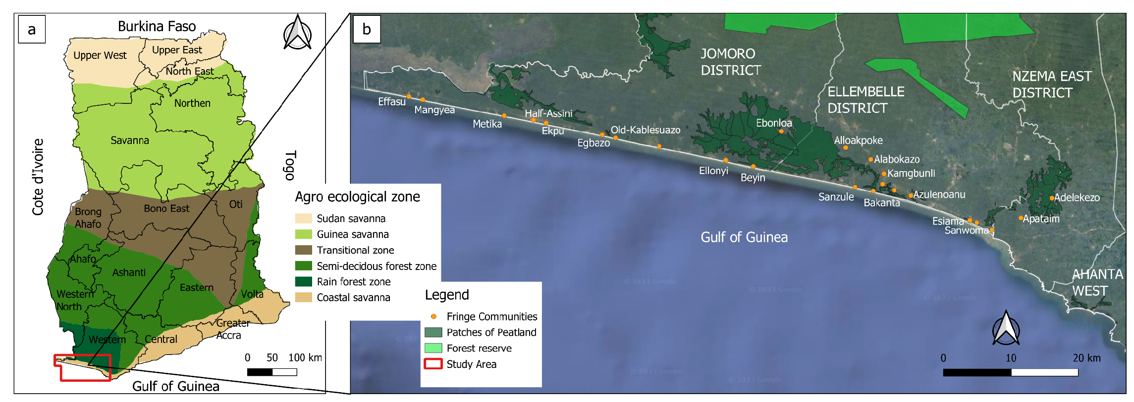
Figure 2.
Digital Elevation Model (DEM) of the study area showing the Amanzule, Tano, and Ankobra rivers. The colour gradients represent variations in terrain elevation, with the scale indicating relative heights in meters above sea level (Source: Author’s own creation using SRTM data accessed via Google Earth Engine).
Figure 2.
Digital Elevation Model (DEM) of the study area showing the Amanzule, Tano, and Ankobra rivers. The colour gradients represent variations in terrain elevation, with the scale indicating relative heights in meters above sea level (Source: Author’s own creation using SRTM data accessed via Google Earth Engine).
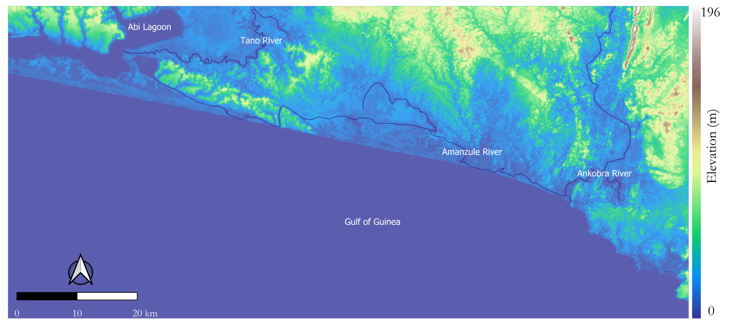
Figure 3.
Workflow for land cover change analysis using multi-sensor data, featuring model building with Random Forest (RF) classification, feature optimization through Recursive Feature Elimination (RFE), and GIS-based land cover projection.
Figure 3.
Workflow for land cover change analysis using multi-sensor data, featuring model building with Random Forest (RF) classification, feature optimization through Recursive Feature Elimination (RFE), and GIS-based land cover projection.
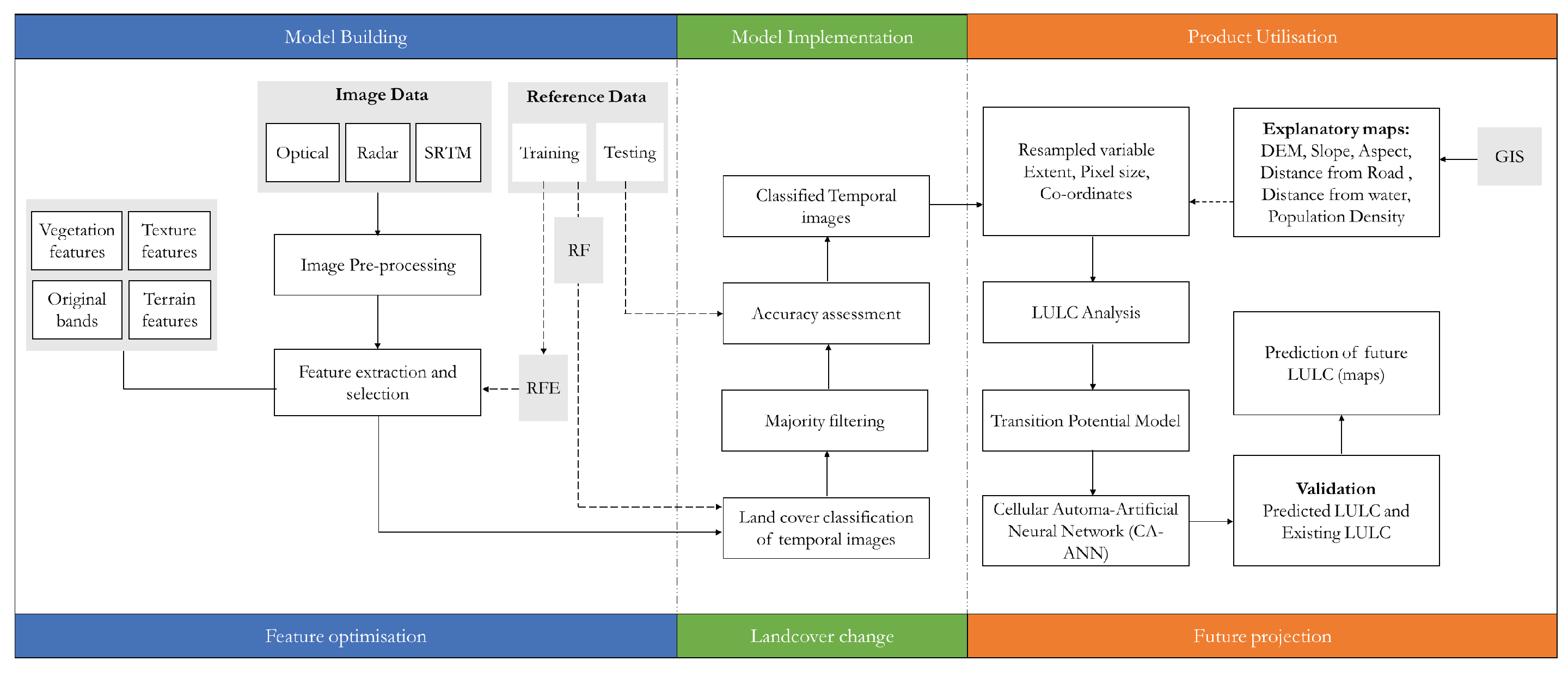
Figure 4.
Plot of Accuracy vs. Number of Image Features.
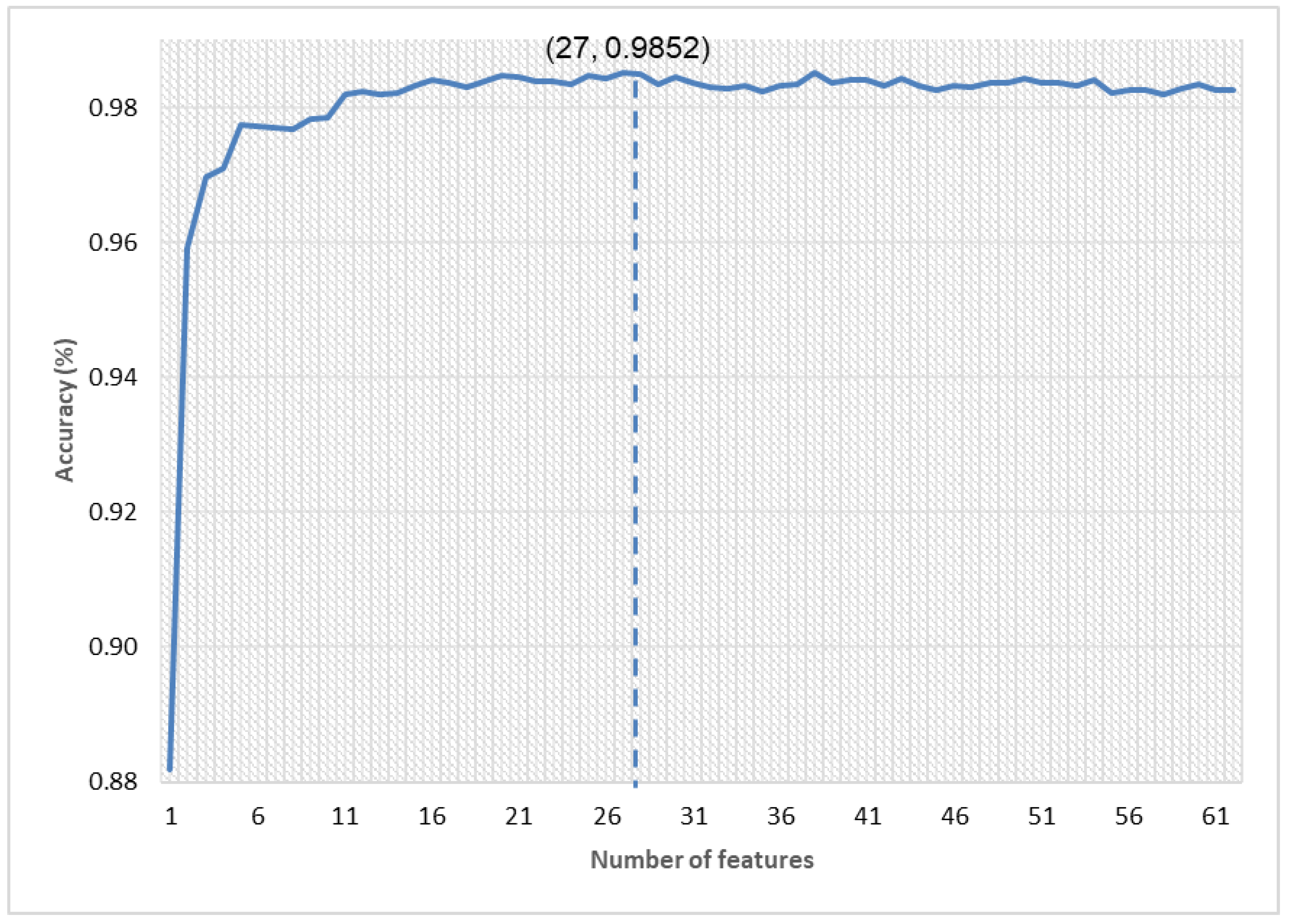
Figure 5.
Feature Importance Scores of Selected Image Features Following RFE. Original bands, texture, spectral indices, and terrain features were chosen based on the number of features that retained optimal accuracy.
Figure 5.
Feature Importance Scores of Selected Image Features Following RFE. Original bands, texture, spectral indices, and terrain features were chosen based on the number of features that retained optimal accuracy.
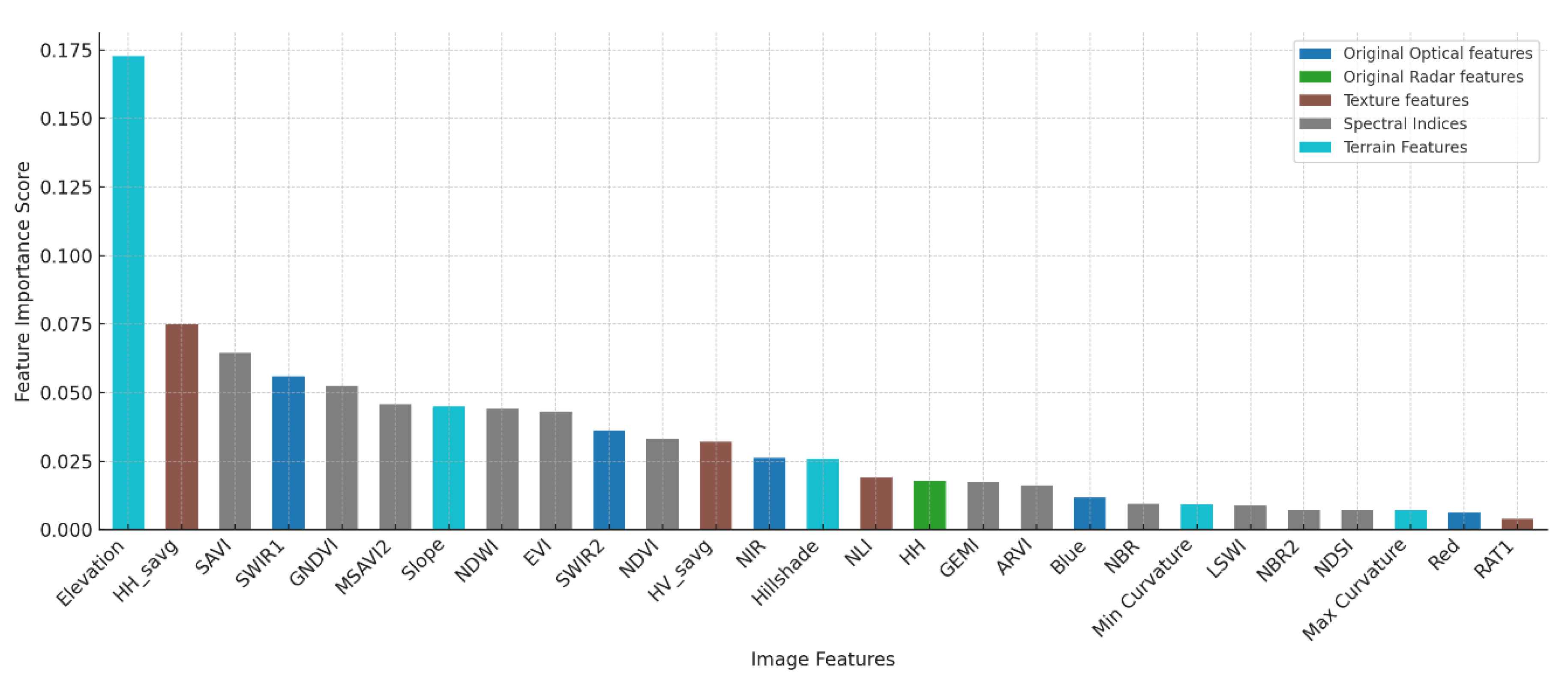
Figure 6.
Areas of land cover change in the GAP (a) 2010 to 2015 (b) 2015 to 2020.
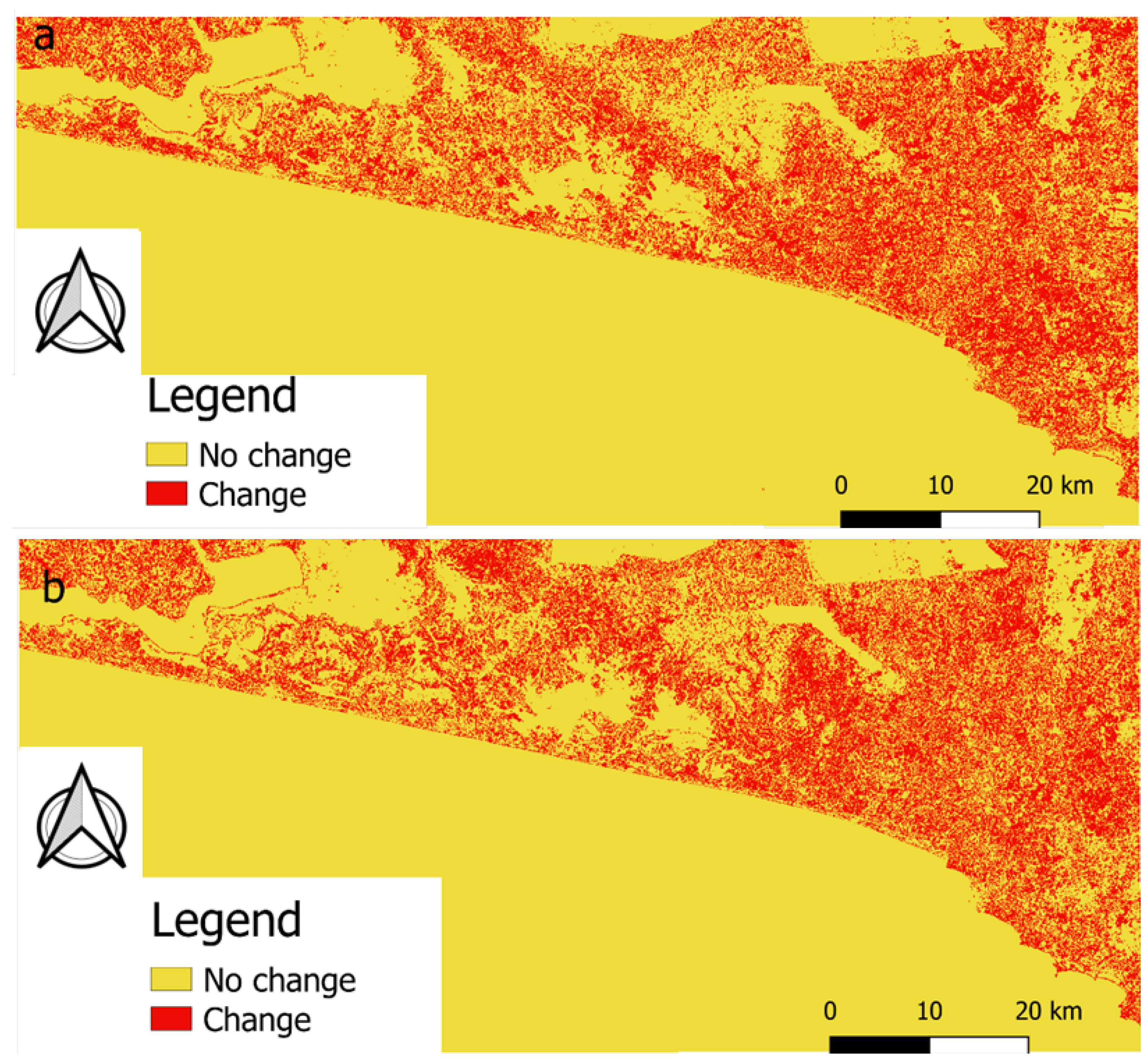
Figure 7.
Land cover maps for GAP from: (a) 2010, (b) 2015 and (c) 2020.
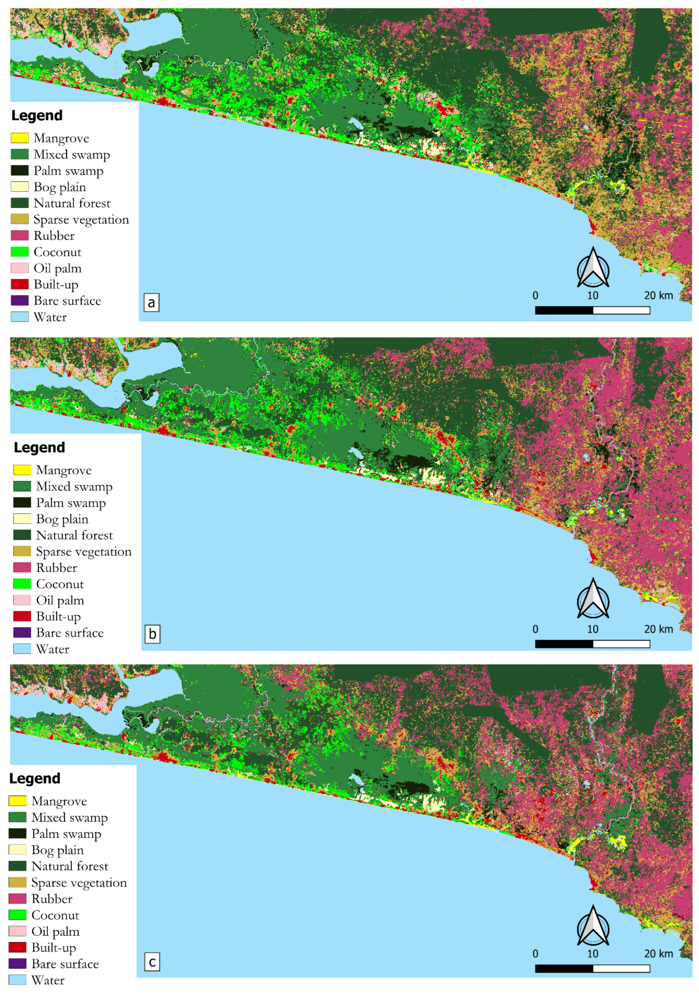
Figure 8.
Sankey diagram illustrating dynamic land cover transitions from 2010 to 2020
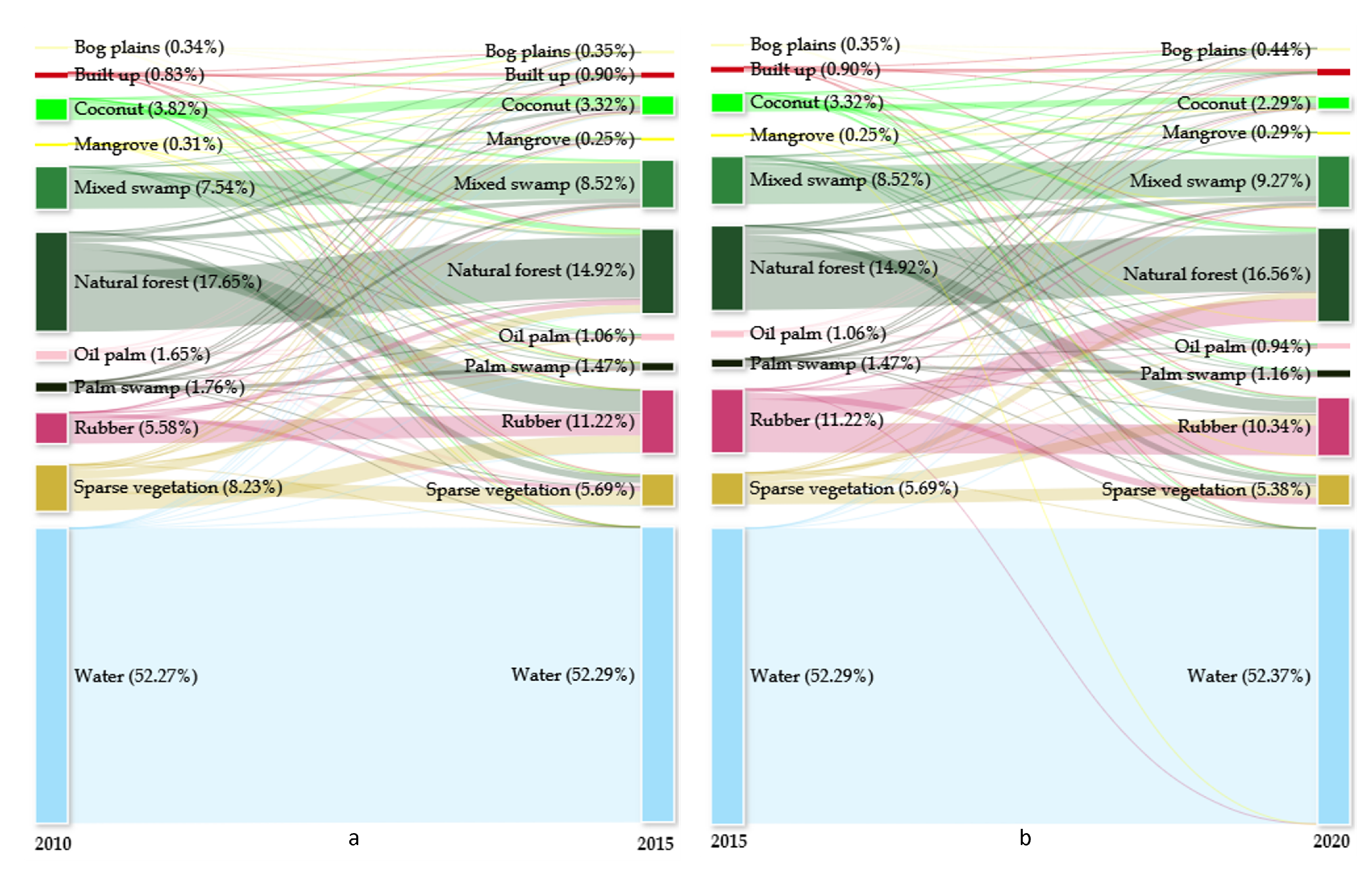
Figure 9.
Early Growth Stages of replanted mangroves in GAP (Source: Hen Mpoano, [12]).
Figure 9.
Early Growth Stages of replanted mangroves in GAP (Source: Hen Mpoano, [12]).
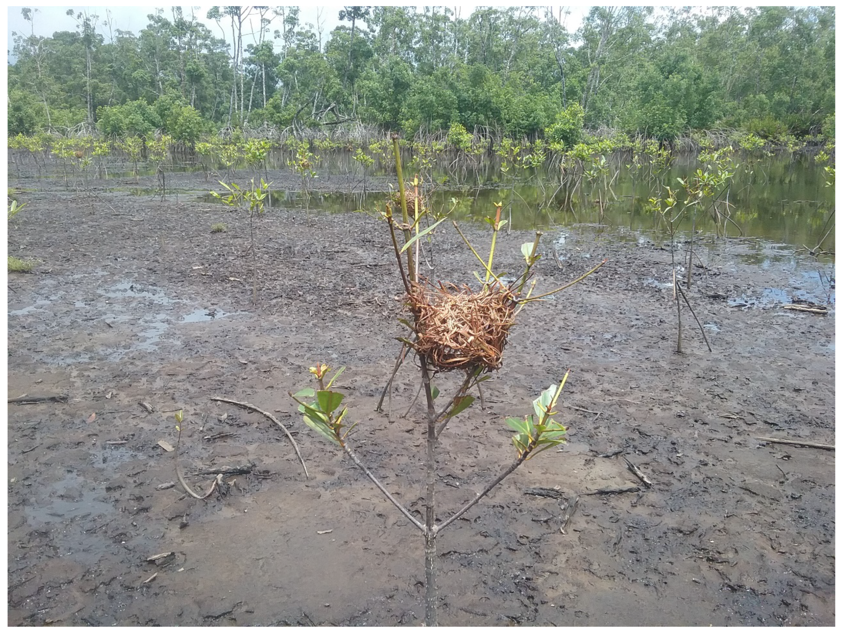
Table 1.
Landcover Classification Scheme
| General class | Land cover class | Class Description |
|---|---|---|
| Peatland | Mangrove swamp | Mangrove cover along coastal areas |
| Mixed swamp | Permanent and regularly flooded broadleaved trees and palm (Raphia sp.) | |
| Palm swamp | Permanent and regularly flooded areas of palm (predominantly Raphia sp.) | |
| Bog plain | Areas dominated by permanent and regularly flooded areas of grasses | |
| Forest | Natural forest | Closed broadleaved evergreen forest with trees from medium to large sizes |
| Sparse | Sparse vegetation | Areas of sparse and/or stunted plant growth including other agricultural lands (i.e., young plantation trees, rainfed croplands) |
| Plantation | Coconut | Plantation of mature coconut trees |
| Rubber | Plantation of mature rubber trees | |
| Oil palm | Plantation of mature oil palm trees | |
| Artificial and bare areas | Built-up | Developed land such as buildings, asphalt roads and concrete surfaces, human settlements, industrial facilities |
| Bare surface | Areas of exposed soil or ground/ open areas devoid of trees, grass or other vegetation; often comprising land cleared for development | |
| Hydrology | Water | Water bodies such as rivers, canals, lakes and sea |
Table 3.
Initial image features serving as potential predictors.
| Datasets | Features | Description | Number of features |
|---|---|---|---|
| Optical | Red, Green, Blue, NIR, SWIR1, SWIR2, GNDVI, MSAVI2, NDWI, EVI, NDVI, GEMI, ARVI, NBR, LSWI, VSSI, NBR2, NDSI, BI, SI, SAVI | Spectral bands and indices for vegetation (Normalized Difference Vegetation Index ; Enhanced Vegetation Index; Green Normalized Difference Vegetation Index; Modified Soil-Adjusted Vegetation Index 2; Soil Adjusted Vegetation Index; Global Environmental Monitoring Index; Atmospherically Resistant Vegetation Index), water content (Normalized Difference Water Index; Land Surface Water Index), soil and structural properties (Normalized Burn Ratio; Normalized Burn Ratio 2; Normalized Difference Salinity Index; Brightness Index; Salinity Index; Vegetation Soil Salinity Index), enhancing landscape characterization. | 21 |
| Radar | HH_savg, HH_contrast, HV_contrast, HV_diss, HH_idm, HV_idm, HH_corr, HH_amp, HV_amp, HV_corr, HH_ent, HV_asm, HH_asm, HV_var, HH_diss, NDI, HV_stdDev, Diff, R1, R2, HV_savg, NLI, HH, HH_stdDev, HV, HH_var, HV_ent, Avg | Texture features from Synthetic Aperture Radar data (contrast, correlation, dissimilarity, entropy, angular second moment, variance, smoothed average - savg, standard deviation - stdDev, amplitude - amp) and indices (Normalized Difference Index - NDI; Average - Avg; Difference - Diff; Ratios - R1, R2; Normalized Lateral Index - NLI) to capture physical landscape variations, aiding in detailed land cover classification. | 28 |
| Terrain | Elevation, Eastness, Shape Index, Northness, Slope, Hillshade, Gaussian Curvature, Mean Curvature, Vertical Curvature, Aspect, Horizontal Curvature, Minimal Curvature, Maximal Curvature | Topographic attributes from Shuttle Radar Topography Mission data, providing essential context for geomorphological analysis and land cover distribution. | 13 |
| Total number of features considered for the classification | 62 | ||
Table 4.
Model Precision, Recall and F-score metrics of GAP for individual land cover categories and overall classification. Metrics are presented for each land cover class in the 2010, 2015, and 2020 datasets.
Table 4.
Model Precision, Recall and F-score metrics of GAP for individual land cover categories and overall classification. Metrics are presented for each land cover class in the 2010, 2015, and 2020 datasets.
| General classes | Land cover classes | 2010 | 2015 | 2020 | ||||||
|---|---|---|---|---|---|---|---|---|---|---|
| Precision | Recall | F-score | Precision | Recall | F-score | Precision | Recall | F-score | ||
| Peatland | Mangrove | 0.91 | 0.59 | 0.72 | 0.68 | 0.36 | 0.47 | 0.70 | 0.74 | 0.72 |
| Mixed swamp | 0.97 | 0.93 | 0.95 | 0.95 | 0.92 | 0.94 | 0.97 | 0.90 | 0.93 | |
| Palm swamp | 0.75 | 0.75 | 0.75 | 0.77 | 0.75 | 0.76 | 0.80 | 0.69 | 0.74 | |
| Bog plain | 0.95 | 0.74 | 0.83 | 0.75 | 0.90 | 0.82 | 0.81 | 0.76 | 0.78 | |
| Natural forest | 0.95 | 0.97 | 0.96 | 0.94 | 0.99 | 0.97 | 0.94 | 0.99 | 0.97 | |
| Sparse vegetation | 0.18 | 0.24 | 0.20 | 0.37 | 0.41 | 0.39 | 0.38 | 0.50 | 0.43 | |
| Plantation | Rubber | 0.89 | 0.96 | 0.93 | 0.93 | 0.77 | 0.84 | 0.68 | 0.48 | 0.57 |
| Coconut | 0.49 | 0.55 | 0.52 | 0.40 | 0.47 | 0.43 | 0.28 | 0.54 | 0.37 | |
| Oil palm | 0.83 | 0.51 | 0.63 | 0.13 | 0.67 | 0.21 | 0.38 | 1 | 0.55 | |
| Artificial surface | Built-up | 0.86 | 0.99 | 0.92 | 0.99 | 0.88 | 0.93 | 0.99 | 0.90 | 0.95 |
| Bare surface | 1 | 0.75 | 0.86 | 1 | 0.50 | 0.67 | 1 | 0.75 | 0.86 | |
| Water | 0.99 | 0.99 | 0.99 | 1 | 1 | 1 | 1 | 1 | 1 | |
| OA | 93% | 94% | 94% | |||||||
Table 5.
Accuracy adjusted land cover area and changes. Area of change corresponds to the proportion of the total area. General landcover classes and the associated changes are in bold. (-) denote area decrease of the landcover type. See Table 1 for the definitions of landcover types.
Table 5.
Accuracy adjusted land cover area and changes. Area of change corresponds to the proportion of the total area. General landcover classes and the associated changes are in bold. (-) denote area decrease of the landcover type. See Table 1 for the definitions of landcover types.
| Landcover type | 2010 | 2015 | 2020 | 2015/2010 change (ha) | 2020/2015 Change (ha) | 2020/2010 Change (ha) |
|---|---|---|---|---|---|---|
| Mangrove | 1687.31 ± 6.13 | 1390.26 ± 5.05 | 1599.47 ± 6.24 | -297.05 ± 7.91 | 209.21 ± 7.93 | -87.84 ± 8.76 |
| Mixed swamp | 41285.57 ± 150.06 | 46643.83 ± 169.53 | 50736.49 ± 197.96 | 5358.26 ± 226.30 | 4092.66 ± 260.01 | 9450.92 ± 245.71 |
| Palm swamp | 9647.91 ± 35.07 | 8046.48 ± 29.25 | 6326.00 ± 24.68 | -1601.43 ± 45.50 | -1720.48 ± 38.20 | -3321.91 ± 42.82 |
| Bog plains | 1881.89 ± 6.84 | 1892.77 ± 6.88 | 2410.98 ± 9.41 | 10.88 ± 9.74 | 518.21 ± 11.53 | 529.09 ± 11.64 |
| Peatland | 54502.68 ± 198.10 | 57973.34 ± 210.71 | 61072.94 ± 238.29 | 3470.66 ± 289.38 | 3099.6 ± 317.45 | 6570.26 ± 308.59 |
| Natural forest | 96623.40 ± 351.19 | 81683.75 ± 296.89 | 90658.03 ± 353.72 | -14939.65 ± 458.76 | 8974.28 ± 461.82 | -5965.37 ± 497.73 |
| Sparse vegetation | 45064.16 ± 163.79 | 31119.10 ± 113.11 | 29424.84 ± 114.81 | -13945.06 ± 195.82 | -1694.26 ± 161.04 | -15639.32 ± 196.85 |
| Rubber | 30530.00 ± 110.96 | 61438.56 ± 223.31 | 56617.24 ± 220.90 | 30908.56 ± 237.78 | -4821.32 ± 313.80 | 26087.24 ± 235.21 |
| Coconut | 20919.19 ± 76.03 | 18183.26 ± 66.09 | 12538.92 ± 48.92 | -2735.93 ± 100.85 | -5644.34 ± 81.76 | -8380.27 ± 88.77 |
| Oil-palm | 9016.27 ± 32.77 | 5788.27 ± 21.04 | 5128.89 ± 20.01 | -3228 ± 38.06 | -659.38 ± 29.07 | -3887.38 ± 37.41 |
| Plantation | 60465.47 ± 219.77 | 85410.08 ± 310.43 | 74285.05 ± 289.84 | 24944.61 ± 375.09 | -11125.03 ± 424.68 | 13819.58 ± 361.39 |
| Built-up | 4560.93 ± 16.58 | 4920.67 ± 17.88 | 5207.28 ± 20.32 | 359.74 ± 24.40 | 286.61 ± 27.00 | 646.35 ± 26.22 |
| Bare surface | 23.45 ± 0.09 | 25.68 ± 0.09 | 45.57 ± 0.18 | 2.23 ± 0.13 | 19.89 ± 0.19 | 22.12 ± 0.19 |
| Artificial surface | 4584.38 ± 16.66 | 4946.35 ± 17.98 | 5252.85 ± 20.49 | 361.97 ± 24.48 | 306.5 ± 27.15 | 668.47 ± 26.33 |
| Water | 286131.70 ± 1039.98 | 286239.20 ± 1118.52 | 286678.10 ± 1118.52 | 107.5 ± 1527.81 | 438.9 ± 1595.56 | 546.4 ± 1521.88 |
Table 6.
CA-ANN projections for land cover areas (in hectares) and their changes from 2020 to 2040. It details the forecasted land cover class areas for 2030 and 2040, and quantifies the shifts in land cover from 2020 to 2030, and again from 2020 to 2040.
Table 6.
CA-ANN projections for land cover areas (in hectares) and their changes from 2020 to 2040. It details the forecasted land cover class areas for 2030 and 2040, and quantifies the shifts in land cover from 2020 to 2030, and again from 2020 to 2040.
| Landcover | 2030 | 2020-2030 change | 2040 | 2020-2040 change |
|---|---|---|---|---|
| Mangrove | 1600.20 | 0.73 | 1604.37 | 4.90 |
| Mixed swamp | 50737.23 | 0.73 | 50770.91 | 34.42 |
| Palm swamp | 6325.91 | -0.09 | 6332.60 | 6.60 |
| Bog plains | 2406.53 | -4.45 | 2397.51 | -13.47 |
| Natural forest | 90657.85 | -0.18 | 90646.43 | -11.59 |
| Sparse vegetation | 29415.90 | -8.94 | 29414.42 | -10.42 |
| Rubber | 56618.81 | 1.57 | 56620.03 | 2.79 |
| Coconut | 12534.64 | -4.28 | 12534.27 | -4.66 |
| Oil-palm | 5128.89 | 0.00 | 5142.45 | 13.55 |
| Built-up | 5222.53 | 15.25 | 5230.81 | 23.53 |
| Bare surface | 45.57 | 0.00 | 46.35 | 0.78 |
| Water | 286677.76 | -0.36 | 286631.66 | -46.46 |
Disclaimer/Publisher’s Note: The statements, opinions and data contained in all publications are solely those of the individual author(s) and contributor(s) and not of MDPI and/or the editor(s). MDPI and/or the editor(s) disclaim responsibility for any injury to people or property resulting from any ideas, methods, instructions or products referred to in the content. |
© 2024 by the authors. Licensee MDPI, Basel, Switzerland. This article is an open access article distributed under the terms and conditions of the Creative Commons Attribution (CC BY) license (http://creativecommons.org/licenses/by/4.0/).
Copyright: This open access article is published under a Creative Commons CC BY 4.0 license, which permit the free download, distribution, and reuse, provided that the author and preprint are cited in any reuse.