Submitted:
02 January 2024
Posted:
03 January 2024
You are already at the latest version
Abstract
The Southwest Alpine Canyon Area of China was one of the regions in the world that suffered from severe soil erosion. The focus of this research was to understand the response of land use change on soil loss by water erosion in alpine canyon on Southeast Tibet, we analyzed the characteristics of temporal and spatial dynamics of land use in the Niyang River Basin from 1990 to 2020 using GIS and statistical methods, assessed the spatial and temporal change characteristics of soil erosion in the Niyang River Basin using RUSLE model. For this purpose, the meteorological, soil, topographic, remote sensing data were collected. The results showed the area of cropland and construction land in the Niyang River Basin increased to 2.4 and 6.1 times the original from 1990 to 2020, respectively, the area of forest and water continued to decrease. Grassland, unused land and forest have always been the dominant land types in the Niyang River Basin. Tolerable soil erosion was distributed in the flat areas of the valley terraces in the main stream and its tributaries, slight soil erosion was mainly distributed in the flat areas at high altitudes, and moderate, severe, very severe and destructive soil erosion was sporadically distributed in the Niyang River Basin. The areas of tolerable and slight soil erosion exceeded 82% of the total area, The area of severe, very severe and destructive soil erosion was less than 6%, but the total soil loss amount of severe, very severe and destructive erosion was more than 27%. From 1990 to 2020, the soil erosion area decreased from 9219.34 km2 to 8,090.84 km2 in Niyang River Basin, more than 85% of the soil erosion class has not changed, and the change of total soil loss amount also shows a significant reduction trend as a whole. 99% of the total soil loss amount in the Niyang River basin is generated by grassland, forest and unused land. The conversion of various land use types to cropland will cause the enhancement in soil erosion grade. We recommend that the focus of soil erosion control in the Niyang River Basin is to protect grassland, forest and carry out scientific farming.
Keywords:
soil loss
; water erosion
; land use change
; RUSLE
; Niyang River Basin
1. Introduction
The global average soil erosion rate is 240 t km−2 a−1 [1]. Soil erosion causes annual loss of 25-40 billion tons of topsoil in the world, which is one of the ten most serious environmental problems in the world, it not only causes land degradation and food production reduction, but also brings ecological and environmental problems such as collapse, landslide, debris flow, flood and water pollution [2,3,4].
Land use and land cover change (LUCC) not only objectively recorded the spatial pattern of human changing the features of the Earth's surface, but also reproduced the spatio-temporal dynamic change process of the Earth's surface landscape [5], is the most significant area of global environmental change. Since its launch in 1995 by the International Geosphere–Biosphere Programme (IGBP) and the International Human Dimensions Programme on Global Environmental Change (IHDP), the land use and land cover change research programme has gradually become a hot spot in the study of global change [6,7]. Land use and land cover change has a profound impact on the structure, function and evolution of ecosystems [8], it will cause soil erosion [9,10,11], surface runoff change [12], soil property variation [13,14], Changes in vegetation cover [15], biodiversity change [16,17,18] and so on. Experts in various fields generally believe that human beings and their activities are the main causes of soil erosion, and that unreasonable land use patterns and the reduction of vegetation cover have magnifying effects on soil erosion [11,19,20,21]. Exploring the relationships between land use and soil erosion is a frontier research field and a hot spot topic in contemporary physical geography [10].
In the early stage of soil erosion assessment and monitoring, the standard runoff plots [22] and sand-collecting tables [23,24] were set up at monitoring stations to measure the amount of soil loss in order to evaluate the overall erosion status of the study area, it is difficult to characterize the spatial trend of soil erosion. Since Wischeier [25,26] proposed the term erosivity index, which is defined as the product of the kinetic energy of rainfall and the maximum rainfall intensity in 30 minutes, and applied to the general soil loss equation USLE [27], USLE has been widely used in many countries.
The USLE, or the lateral RUSLE model, is a universally accepted method that can be used as the best fitted model for monitoring soil erosion because its applicability has been proven over the last decades, and the reliability of the results are indisputable [28,29,30]. In China, the cultivated cropland average soil erosion rate is 500 t km−2 a−1 [31], significantly exceeding the global average soil erosion rate. The Loess Plateau in China was one of the regions in the world that suffered from severe soil erosion. In recent years, RUSLE has been applied in the study of the possible influences of land use change on soil erosion in the Chinese Loess Plateau. Fu et al. [32] evaluated the soil erosion control and the land cover changes from 2000 to 2008, found that ecosystem soil erosion control service has been improved as a result of vegetation restoration. Liu et al. [33] reported that the sensitivity of soil erosion reduced significantly from 2000 to 2007. The sensitivity of soil erosion in the southeast region was higher than the northwest region. It was mainly caused by the frequent regional human activities and the unscientific farming. Zhang et al. [34] found that positive measures aimed to increase plantation of shrubberies have dammed the soil shipment is essential. Sun et al. [30] reported that Forest, shrub and dense grassland provided the best protection from erosion, the decadal trend of reduced soil erosion was greater for the lower vegetation cover of woodland and moderate and sparse grassland on the Loess Plateau in China using the Revised Universal Soil Loss Equation (RUSLE).
As a fragile ecosystem with global significance, the Qinghai-Tibet plateau had significant differences in topography, climate and vegetation, including almost all types of soil erosion on land [35]. Southeast Tibet was a region where the edge of the Qinghai-Tibet plateau has been cut violently and was in transition to a lowland. The vertical drop was huge, formed the most densely-packed v-shaped alpine canyons on the Qinghai-Tibet plateau. The soil in the region was loose, and local heavy rainfall was frequent, landslides, debris flows and other natural disasters often occurred [36]. This area was the highest sensitivity to soil loss by water erosion [37]. Since the 1980s, the Niyang River Basin has experienced continuous population growth, rapid economic development and frequent land use changes, it is an ideal region to study soil erosion and land use change in alpine valley of Southeast Tibet. Therefore, this study chooses the Niyang River Basin in Tibet as the research area, based on the basic principles of the Revised Universal Soil Loss Equation (RUSLE), this research took advantage of rainfall erodibility, undulating terrain, soil texture, vegetation cover, analyzed the spatial difference of soil erosion, and assessed the change of soil erosion with changing land cover. It is expected that the results could help us understand the soil erosion change and relationship between land use and soil erosion, and further provide scientific supports for the ongoing ecological construction and regional high-quality development.
2. Materials and Methods
2.1. Study Area
The study area specifically focuses on the Niyang River Basin of Southeast Tibet. The Niyang River is a first-class tributary of the Yarlung Tsangpo River, originating from the valley of ancient glaciation in the west of Mila Mountain, with an elevation of about 5,000 m. It flows from west to east through the Gongbo′gyamda County, Bayip District. joins the Yarlung Tsangpo River near Zemen in Bayip District. The Niyang River has a length of 307.5 km, a drop of 2,273 m, an average longitudinal drop of 7.39%, an average flow rate of 538 m3s-1, and an annual runoff of 22 billion m3, which ranking second among the tributaries of the Yarlung Tsangpo River, second only to the Palung Tsangpo River. The Niyang River Basin (29°23′–30°37′ N, 92°09′–94°40′E) is bounded by the Nyechingtanggula Mountains on its north and east, the remnants of the Gangdise Mountains on its west, and the Yarlung Tsangpo River on its south, with the overall terrain tilting from north-west to south-east (Figure 1). The basin is 240 km east to west and 140 km north to south, covering an area of 17,783 km2 [38]. It is located in the mid-latitude zone, belongs to the plateau temperate semi-humid climate zone. Its altitude is high, air is thin, solar radiation is strong, annual mean temperature is 8℃, and annual precipitation is 600–900 mm [39]. The upper and middle reaches of the Niyang River Basin is the temperate coniferous forest region, which is the transition zone between the humid-semi-humid forest area in eastern Tibet and the semi-arid scrub area in the west, and the lower reaches is the humid mountainous coniferous forest region in the middle and lower reaches of the Yarlung Tsangpo River, with a wide variety of vegetation types [40].
Tibetan ancient Niang tribe had lived in the Niyang River Basin for a long time, so the Niyang River is also known as Niangqu. The term "Nyingchi" (name of the largest city in the Niyang River Basin) is derived from the combined name of the Niang and Chi tribes living in the Niyang River Basin [41]. Nowadays, the Niyang River Basin covers 126 villages of three counties including Gongbo´gyamda, Bayipp and Gyaca. In 2019, the registered population of the Niyang River Basin is 80,300, the resident population reaches 112,500, of which 49.5 thousand rural population [42]. Farmers and herdsmen plant barley, wheat and other food crops, raise cattle, sheep, pigs and other livestock, pick Chinese Caterpillar Fungus and Pine Mushrooms, run homestays, do business and transportation, and also go out to work. The Niyang River Basin is the most economically active area in Southeast Tibet and even in Tibet. The capital city of Nyingchi, Gongbo´gyamda county city is located in the valley terraces of the main stream of the Niyang River. Large hydroelectric power stations in southeast Tibet, such as Xueka Power Station, Laohuzui Power Station and Dobu Power Station, are located on the main stream and tributaries of the Niyang River. National Highway 318 and the La-lin Highway follow the Niyang River upstream and extend to Lhasa.
2.2. Data Collection
The remote sensing data (30 m×30 m) from Geospatial Data Cloud (https://www.gscloud.cn/), included 4 views of Landsat 5 TM in 1990, landsat-7 ETM+ in 2000, landsat-7 ETM+ in 2010 and landsat-8 OLI in 2020. Using ENVI5.1 to preprocess the remote sensing data with radiometric calibration, atmospheric correction, cropping, etc., combined with the actual situation of the study area, and based on the Standard for Current land use classification (GB/T 21010-2017), the current land use is classified as grassland, cropland, construction land, forest, waters and unused land using the supervisory classification method.
Meteorological data were obtained from the National Meteorological Information Centre of the China Meteorological Data Service Centre (http://data.cma.cn), soil data were obtained from the Soil Subcenter of the National Earth System Science Data Center of China (http://soil.geodata.cn), the digital elevation model (DEM) and the Normalized Difference Vegetation Index (NDVI) were obtained from the Geospatial Data Cloud (https://www.gscloud.cn).
2.3. RUSLE Model
The estimation of soil loss rate was conducted using the Revised Universal Soil Loss Equation (RUSLE):
where is the computed annual soil loss rate in year i, in units of t km-2 a-1; is the rainfall-runoff erosivity factor; is a soil erodibility factor; is a slope length factor; is a slope steepness factor; is a cover-management factor; and is a supporting and conservation practices factor.
2.4. R Factor
Zhang et al. (2003) [43] found that daily rainfall data can provide richer information on rainfall characteristics, and the erosive power of rainfall can be estimated more accurately by using daily rainfall data than monthly or annual rainfall data. This study is based on day-to-day rainfall data from six meteorological stations in and around the Niyang River Basin. the methods developed by Xie et al. [44] and Zhang et al. (2002) [45] were employed to calculate the R factor, which is represented by the following equations:
where is the rainfall-runoff erosivity force in year i, in units of (MJ mm)/(ha−1h−1 a−1); is the daily rainfall of day j with soil erosion threshold caused, mm; n is the days with rainfall ≥12 mm in each year, d; is the average daily rainfall of several years with ≥12 mm required, mm; is the average annual rainfall with daily rainfall above 12 mm, in units of mm; and and are the model parameters.
2.5. K Factor
In this study, we use the EPIC model proposed by Williams et al. [46] to calculate the K value. The formula is as following:
where is the soil erodibility factor; , , and are the soil sand, silt, and clay content in %, respectively. The is soil organic carbon content in %.
2.6. L and S Factors
In this study, the L and S factors were calculated by combining the topography and geomorphology of the Niyang River Basin with the formulas proposed by Williams et al. [27] and Liu et al. [47]. The formulas are as follows:
where is the slope length factor; is the slope length, m; is the model parameter of slope length; is the slope angle (gradient), in units of °; and is the steepness factor.
2.7. C Factor
Vegetation cover and management factor C refers to the ratio of soil loss on land with specific vegetation cover or field management to soil loss on bare recreational land with clear-cutting or no vegetation cover under the same soil, slope and rainfall conditions, and its value is between 0 and 1. The larger the C value, the greater the amount of soil erosion caused by this type of land use. Therefore, in this study, we used the Normalized Difference Vegetation Index (NDVI), which is currently the most widely used method, to estimate the vegetation coverage, and then calculated the vegetation cover and management factors using the model proposed by Tsai et al. [48]. The formulas are as follows:
where is the vegetation cover and management factor; is the the vegetation coverage, in units of %; is the Normalized Difference Vegetation Index; is the minimum values in the Normalized Difference Vegetation Index; is the maximum values in the Normalized Difference Vegetation Index.
2.8. P Factor
The conservation practice factor P represents the ratio of soil loss achieved with a specific conservation practice compared to the soil loss without specific conservation practice under the same conditions. On the basis of the actual investigation of the study area, combined with previous research and experience [49,50], the values were assigned to different land use types. The P factors for forest, grassland, construction land, water, cropland and unused land were 1.00, 1.00, 0, 0, 0.35 and 1, respectively.
2.9. Soil Erosion Classification
3. Results
3.1. Land Use Changes from 1990 to 2020
The Niyang River Basin is a typical alpine valley with obvious vertical zonation. Cropland and construction land were distributed in flat valley terraces at lower elevations. Forest, grassland and unused land were distributed sequentially with the increase in elevation, and waters were scattered all over (Figure 2).
From 1990 to 2000, the area of various types of land in the Niyang River Basin changed slightly, and the proportion of various land use type remained the same; after 2000, the proportion of forest and water continued to decrease (Figure 3). The proportion of forest decreased from 31.95% in 2000 to 27.77% in 2010 and then to 27.63% in 2020; the proportion of water area decreased from 5.44% in 2000 to 3.07% in 2010 and then to 3.03% in 2020. Unused land and grassland increased and then decreased, with the proportion of unused land increased from 28.10% in 2000 to 28.15% in 2010, and then decreased to 28.04% in 2020; the proportion of grassland increased from 33.99% in 2000 to 40.00% in 2010, and then decreased to 39.97% in 2020. Construction land and cropland showed a continuous increase, with the proportion of cropland increased from 0.48% in 2000 to 0.94% in 2010, and then to 1.17% in 2020; construction land increased from 0.03% in 2000 to 0.06% in 2010, and then to 0.17% in 2020 (Table 2). Grassland, unused land and forest have always been the dominant land types in the Niyang River Basin.
3.2. Spatio-Temporal Changes of Soil Erosion
3.2.1. Temporal Variation of Soil Erosion
The average value of soil loss rate by water erosion in the Niyang River Basin decreased from 1,625.46t km-2a-1 in 1990 to 1,254.99t km-2a-1 in 2000, then increased to 1,357.03t km-2a-1 in 2010, and finally decreased to 961.03t km-2a-1 in 2020, where the minimum value was 0 and the maximum value was 238,581.47t km-2a-1 in 2010 (Table 3).
The areas affected by slight, moderate, severe, very Severe, and destructive erosion has been increasing and then decreasing. From 1990 to 2010, the soil erosion area increased continuously from 9,219.34 km2 to 9,703.65 km2, with an increase of 484.31 km2, or 5.25%, and the percentage of erosion area increased continuously from 52.76% to 55.53% (Table 4). Subsequently, the area of soil erosion decreased to 8,090.84 km2 in 2020, a decrease of 1,612.81 km2, a decrease of 16.62%, and the percentage of soil erosion area decreased to 46.65% (Table 4). It shows that the local ecological environmental protection policy is effective and soil erosion has been effectively treated.
The sum of the areas of tolerable and slight erosion exceeds 82% of the total area (Table 4). The proportion of moderate erosion, severe erosion, very severe erosion and destructive erosion decreased in order, and showed a decreasing trend year by year. It shows that the natural environment of the Niyang River Basin is healthy and getting better.
From 1990 to 2020, the total soil loss amount decreased from 27.46Mt to 21.98Mt, showed a significant reduction, of which the total soil loss amount increased from 2000 to 2010, from 21.77Mt to 24.11Mt. The area of tolerable and slight soil erosion was more than 44%, but the total soil loss amount of tolerable and slight soil erosion was less than 4%. The area of severe, very severe and destructive soil erosion was less than 6%, but the total soil loss amount of severe, very severe and destructive erosion was more than 27%, up to 38.7% (Figure 4).
From 1990 to 2020, more than 85% of the soil erosion classes in the Niyang River Basin remained unchanged, and except for the period 2000-2010, when the number of soil erosion classes enhanced was greater than the number of soil erosion classes weakened; in the other two periods, the number of soil erosion classes weakened was greater than the number of soil erosion classes enhanced (Table 5).
3.2.2. Spatial Variation of Soil Erosion
Tolerable soil erosion was distributed in the flat areas of the valley terraces of the main stream and its tributaries, slight soil erosion was mainly distributed in the flat areas at high altitudes, and moderate, severe, very severe and destructive soil erosion was sporadically distributed in the Niyang River Basin (Figure 5). Bujiu Township, Linzhi Township, Bayi Township, Gengzhang Township was located in the lower reaches of the Niyang River at low altitude valleys there were very few moderate, severe, very severe and destructive grades of erosion (Figure 5). Very severe and destructive soil erosion did not exist in Bujiu township. In 2020, 71.38% of the area of destructive soil erosion was concentrated in Jiaxing Township, Niangpu Township, Baiba Township and Cuogao Township, which were characterized by high erosion intensity because of their undulating topography and abundant precipitation (Figure 5).
From 1990 to 2000, the areas with enhanced soil erosion intensity were mainly distributed in the valley terraces of the main stream and its tributaries, and the other areas showed an overall positive trend. The intensive human farming activities in the valley in this period were the main reason for the deterioration of soil erosion (Figure 6). From 2000 to 2010, the area of soil erosion enhancement expanded significantly, showing the characteristics of scattered distribution (Figure 6). From 2010 to 2020, the trend of soil erosion deterioration was significantly curbed, the deterioration area retreated to a small number of sporadic distributions, and soil and water conservation in the eastern part of the Niyang River Basin as a whole tended to improve (Figure 6).
3.3. Soil Erosion Characteristics of Different Land Use Types and Their Variability
3.3.1. Soil Erosion Characteristics of Different Land Use Types
In 2020, the soil erosion of different land use types in the Niyang River Basin was shown in Table 6, 61.54% of the area of unused land undergoes soil erosion. Soil erosion was present in 49.6% of the area of grassland, 29.86% of the area of forest and of 27.42% of the area of cropland. There was no significant erosion, i.e., tolerable erosion, of waters such as rivers, lakes, glaciers and perpetual snow, and of construction land such as urban residential land and transportation land (Table 6).
From 1990 to 2020, with the increase in the area of grassland and cropland, the area share of each grade of soil erosion in grassland and cropland also gradually increased; with the decrease in the area of forest, the area share of each grade of soil erosion in forest also gradually decreased. There was little change in the area of unused land, but there was a significant increase in the area of moderate, severe, very severe, and destructive soil erosion of unused land.
49.51% of the area of destructive soil erosion occurs in grassland, which is much higher than the proportion of the area of grassland in all land use types in the same period (40.15%); 33.18% and 31.47% of the area of very severe and destructive soil erosion occurs in forest, which is higher than the proportion of the area of forest in all land use types in the same period (27.34%) (Table 2 and Table 7). In the future, for the management of the severest soil erosion, attention should be paid to grassland and forest.
99% of the total soil loss amount in the Niyang River Basin was generated by grassland, forest and unused land. From 1990 to 2020, with the increase of grassland area, but its corresponding soil loss amount fluctuated from 9.91Mt to 9.63Mt; with the reduction of the area of forest, its corresponding soil loss amount decreased from 10.01Mt to 6.83Mt; the amount of soil loss generated by the unused land was also fluctuating and decreased from 7.54Mt to 5.37Mt. with the significant increase of cropland area, the corresponding soil loss amount increases from 0.01Mt to 0.16Mt (Table 8). Although the amount of soil loss generated by cropland accounts for a small percentage, it showed a continuous and rapid increase that is worthy of attention and is the focus of local soil erosion control.
3.3.2. Soil Erosion Characteristics of Land Use Changes
From 1990 to 2020, more than 84% of the area with no change in soil erosion class in the Niyang River Basin occurred in grassland, forest and unused land, due to the fact that these were the main land use types (Table 9). Changes in soil erosion class fall into two categories: enhancement and weakening. From 1990 to 2000 and from 2010 to 2010, less than 1% of the area of soil erosion class enhancement or reduction in the Niyang River Basin occurred in various types of land use change, and the rest occurred in forest, grassland, unused land and cropland where there is no change in land use type, of which the proportion of the area of soil erosion class enhancement in the forest to the total area of soil erosion class enhancement was 68.08% and 42.57%, respectively, both of which were much higher than the proportion of the forest area in all land use types in the same period; the proportion of the area of soil erosion class enhancement in the cropland to the total area of soil erosion class enhancement was 0.61% and 1.17%, respectively, both of which were much higher than the proportion of the cropland area in all land use types in the same period (Table 9).
From 2010 to 2020, less than 1% of the area of soil erosion class reduction in the Niyang River Basin caused by the conversion of grassland to cropland, cropland to grassland, cropland to forest, forest to grassland, forest to cropland and unused land to cropland. Nearly 3% of the area of soil erosion class enhancement caused by conversion of grassland to cropland, cropland to grassland, forest to grassland, forest to cropland, water to cropland, water to forest, and unused land to cropland (Table 9). It can be seen that the conversion of grassland, forest, unused land to cropland and cropland and forest to grassland caused bidirectional variation in soil erosion grade, and the possibility of soil erosion grade enhancement was higher than soil erosion grade weakening; the conversion of water to forest and cropland caused soil erosion grade enhancement, and the conversion of cropland to forest will caused soil erosion grade weakening.
4. Discussion
Grassland, unused land and forest were the dominant land types in the Niyang River Basin. From 1990 to 2000, the area of various types of land in the Niyang River Basin changed slightly. From 2000 to 2010, as the resident population in the Niyang River Basin increased by 207,00 people and investment in fixed assets increased by 2.07 billion CNY [52], the area of cropland and construction land increased to 2 times the original, respectively, and forest and water decreased, percentage of grassland area increased from 33.99% to 40.00%, which aligns well with a previous study by Wang et al. [53]. According to their findings, the overall trend on vegetation coverage emerged as an approximate stability with a little increasing, among which the valley regions increased significantly in Bayip District. This change is closely related to human activities. From 2010 to 2020, the resident population increased by 32,500 people, investment in fixed assets increased by 29.44 billion CNY, and cropland and construction land continued to increase, while all other types of land use decreased slightly [54].
Tolerable soil erosion was distributed in the flat areas of the valley terraces of the main stream and its tributaries, slight soil erosion was mainly distributed in the flat areas at high altitudes, and moderate, severe, very severe and destructive soil erosion was sporadically distributed in the Niyang River Basin. The valley terraces at the bottom of the Niyang River Basin canyon were flat, warm and humid, suitable for plantation and urban construction [55], and human activities were more intensive, but no significant soil erosion occurred in this region. This is because water, construction land and cropland were the dominant land types in the valley terraces, there was tolerable erosion of water and construction. In addition, there was no significant soil erosion of cropland with a gentle topography and very small amounts. The residual planation surface was an excellent summer pasture [55], there was slight soil erosion because gentle topography. In other areas, the vertical drop was huge, the soil in the region was loose, and localized heavy rainfall was frequent [36], so soil erosion was more serious.
The areas of tolerable and slight erosion exceeded 82% of the total area, it shows that the natural environment of the Niyang River Basin was healthy. The proportion of moderate erosion, severe erosion, very severe erosion and destructive erosion decreased in order, and showed a decreasing trend year by year. It shows that the natural environment of the Niyang River Basin was healthy and getting better. The area of tolerable and slight soil erosion was more than 44%, but the total soil loss amount of tolerable and slight soil erosion was less than 4%. The area of severe, very severe and destructive soil erosion was less than 6%, but the total soil loss amount of severe, very severe and destructive erosion was more than 27%, the area of different grades of soil erosion in Niyang River Basin and the corresponding soil loss amount were inverted, which aligns well with a study by Guo et al. [56]. Therefore, the severest soil erosion should be the key area to be treated.
From1990 to 2020, the resident population of the Niyang River Basin increased by 70,700 people, while the population urbanization level increased from 27.12% to 56%. This means that a large number of human activities were concentrated on construction land. Therefore, the change of soil erosion area showed a trend of increase and then decrease, more than 85% of the soil erosion class had not changed, and the change of total amount of soil loss also showed a significant reduction trend as a whole. It shows that the local government of Tibet attached importance to the construction of ecological civilization, actively promoted the protection and construction of ecological security barrier, and the policy of ecological environmental protection was effective.
Because grassland, unused land and forest were the dominant land types in the Niyang River Basin, 99% of the total soil loss amount in the Niyang River basin was generated by grassland, forest and unused land, which aligns well with a previous study by Ding et al. [57]. The proportion of very severe and destructive soil erosion areas in grassland and forest was much higher than the proportion of grassland and forest areas in all land use types. From 2010 to 2020, nearly 3% of the enhancement in soil erosion grade was caused by changes of cropland, forest, and grassland, and in particular, the conversion of various land use types to cropland caused the enhancement in soil erosion grade, which aligns well with previous studies by Liu et al. [33], Jiang et al. [50], Guo et al. [56], Ding et al. [57] and Cao et al. [58], but the amount of soil loss was not significant. This was due to the fact that the Niyang River Basin was sparsely populated, and limited human activity activities were concentrated on construction land in the gentle valley terraces, and the utilization of cropland has not had a significant impact on soil erosion. Therefore, the focus of soil erosion control in the Niyang River River Basin is to protect grassland, forest and carry out scientific farming.
5. Conclusions
Grassland, unused land and forest were the dominant land types in the Niyang River Basin. From 1990 to 2000, the area of various types of land in the Niyang River Basin changed slightly. From 2000 to 2020, the proportion of forest and water continued to decrease, the proportion of unused land decreased volatility, the proportion of grassland increased volatility, and the proportion of construction land and cropland continued to increase.
The areas of tolerable and slight erosion exceeded 82% of the total area, The area of severe, very severe and destructive soil erosion was less than 6%, but the total soil loss amount of severe, very severe and destructive erosion was more than 27%. Tolerable soil erosion was distributed in the flat areas of the valley terraces of the main stream and its tributaries, slight soil erosion was mainly distributed in the flat areas at high altitudes, and moderate, severe, very severe and destructive soil erosion was sporadically distributed in the Niyang River Basin.
From 1990 to 2020, the change of soil erosion area showed a trend of increase and then decrease, more than 85% of the soil erosion class had not changed, and the change of total amount of soil loss also showed a significant reduction trend as a whole.
99% of the total soil loss amount in the Niyang River basin was generated by grassland, forest and unused land. The proportion of very severe and destructive soil erosion areas in grassland and forest was much higher than the proportion of grassland and forest areas in all land use types. The conversion of various land use types to cropland caused the enhancement in soil erosion grade.
Author Contributions
Z.Z. and Q.X. proposed the research concept; J.G. and L.H. collected the data from papers and other sources; J.G. and Y.Z. ran the model, and produced figures and tables; J.G. wrote the initial manuscript; Z.Z. and H.Y. reviewed and edited the manuscript. All authors have read and agreed to the published version of the manuscript.
Funding
Please add: This research was supported by the Natural Science Foundation Projects of Tibet, grant number XZ202001ZR0049G.
Data Availability Statement
We collected data from various resources, all of them are stated in the paper.
Acknowledgments
We are grateful to our colleague who assisted with English polish, namely Jing Duan.
Conflicts of Interest
The authors declare no conflict of interest.
References
- Wuepper, D.; Borrelli, P.; Finger, R. Countries and the global rate of soil erosion. Nat. Sustain 2019, 3, 51–55. [Google Scholar] [CrossRef]
- Boardman, J.; Poesen, J. Soil Erosion in Europe, 1st ed.; John Wiley & Sons: New Jersey, USA, 2006; pp. 729–742. [Google Scholar]
- Lal, R.; Pimentel, D. Soil erosion: a carbon sink or source? Science 2008, 319, 1040–1042. [Google Scholar] [CrossRef] [PubMed]
- Zhang, X.; Walling, D.E.; Quine, T.A.; Wen, A. Use of Reservoir Deposits and Caesium-137 Measurements to Investigate the Erosional Response of a Small Drainage Basin in the Rolling Loess Plateau Region of China. Land Degrad. Dev. 1997, 8, 1–16. [Google Scholar] [CrossRef]
- Shi, P.; Song, C.; Jing, G. Strengthening the study of land use/ cover change and its impact on eco-environmental security--The trend of the study of the dynamics of human-nature system based on “global change open science conference 2001” in Amsterdam, Netherlands. Adv. Earth Sci. 2022, 17, 161-168. (In Chinese with English Abstract).
- Kuang, W.; Zhang, S.; Du, G.; Yan, C.; Wu, S.; Li, R.; Lu, D.; Pan, T.; Ning, J.; Guo, C.; Dong, J.; Bao, Y.; Chi, W.; Dou, Y.; Hou, Y.; Yin, Z.; Chang, L.; Yang, J.; Xie, J.; Qiu, J.; Zhang, H.; Zhang, Y.; Yang, S.; Sa, R.; Liu, J. Remotely sensed mapping and analysis of spatio-temporal patterns of land use change across China in 2015-2020. Acta Geol. Sin. 2022, 77, 1056-1071. (In Chinese with English Abstract).
- Global Land Project Science Plan and Implementation Strategy. IGBP Secretariat: Stockholm, Sweden, 2005; pp.1-8.
- Deng, J.S.; Wang, K.; Hong, Y.; Qi, J.G. Spatio-temporal dynamics and evolution of land use change and landscape pattern in response to rapid urbanization. Landsc. Urban Plan. 2009, 92, 187–198. [Google Scholar] [CrossRef]
- Follett, R.F.; Stewart, B.A. Soil Erosion and Crop Productivity. J. Range Manage. 1987, 40, 95. [Google Scholar]
- Fu, B.; Zhao, W.; Chen, L.; Lü, Y.; Wang, D. A multiscale soil loss evaluation index. Chin. Sci. Bull. 2006, 51, 448–456. [Google Scholar] [CrossRef]
- Yang, W.; Wang, Z.; Sui, G.; Chen, B.; Xu, K.; Zhang, K.; Bian, Z. Temporal and spatial distribution of soil erosion on red soil slope field under different land use patterns. Chin. J. Appl. Eco 1998, 9, 155-158. (In Chinese with English Abstract).
- Li, Z.; Liu, W.; Zhang, X.; Zheng, F. Impacts of land use change and climate variability on hydrology in an agricultural catchment on the Loess Plateau of China. J. Hydrol. 2009, 377, 35–42. [Google Scholar] [CrossRef]
- Gao, Z.; Peng, B.; Yu, J.; Pu, L.; Zhang, L. Effect of land use changes on soil conditions in the developed areas: a case of Kunshan in Jiangsu Province. J. Nat. Resour. 2005, 20, 44-51. (In Chinese with English Abstract).
- Wu, W.; Yang, P.; Tang, H.; Ongaro, L.; Ryosuke, S. Regional Variability of the Effects of Land Use Systems on Soil Properties. Agric. Sci. Chin. 2007, 6, 1369–1375. [Google Scholar] [CrossRef]
- Liu, J.; Gao, J. Effects of climate and land use change on changes of vegetation coverage in faring-pastoral of ecotone of Northern China. Chin. J. Appl. Ecol. 2008, 19, 2016-2022. (In Chinese with English Abstract).
- Kleijn, D.; Kohler, F.; Baldi, A.; Batary, P.; Concepcion, E.D.; Clough, Y.; Diaz, M.; Gabriel, D.; Holzschuh, A.; Knop, E.; Kovacs, A.; Marshall, E.J.; Tscharntke, T.; Verhulst, J. On the relationship between farmland biodiversity and land-use intensity in Europe. Proc Biol Sci 2009, 276, 903–909. [Google Scholar] [CrossRef]
- Veech, J.A. Incorporating socioeconomic factors into the analysis of biodiversity hotspots. Appl. Geogr. 2003, 23, 73–88. [Google Scholar] [CrossRef]
- Wang, S.; Ge, Y.; Wang, S.; Zhang, X.; Yang, Y. Responses of plant species diversity to land use change: a case study in the Heihe River Basin. J. Desert Res. 2022, 42, 221–232. [Google Scholar]
- Borrelli, P.; Panagos, P.; Märker, M.; Modugno, S.; Schütt, B. Assessment of the impacts of clear-cutting on soil loss by water erosion in Italian forests: First comprehensive monitoring and modelling approach. Catena 2017, 149, 770–781. [Google Scholar] [CrossRef]
- Liu, C.; Qi, S.; Shi, M. Process of study on relationship between land use change and soil erosion. J. Soil Water Conserv. 2001, 15, 10-17. (In Chinese with English Abstract).
- Zou, Y.; Zhang, Z.; Zhou, Q.; Liu, B.; Wang, B. Analysis of the relationship between soil erosion and land use based on GIS. Res. Soil Water Conserv. 2002, 9, 67-69. (In Chinese with English Abstract).
- Li, Y.; Zhou, Y.; Bai, X.; Qin, L.; Li, P.; Luo, G.; Zhang, S. The centennial history of monitoring soil and water loss by runoff plot method (1915-2014). Soil Water Conserv. Chin. 2014, 393, 63-66. (In Chinese with English Abstract).
- Bagnold, R.A. The Physics of Blown Sand and Desert Dunes. Springer: Dordrecht, The Netherlands, 1973; pp. 77-84.
- Ploey, J.D. Some experimental data on slopewash and wind action with reference to quaternary morphogenesis in Belgium. Earth Surf. Processes 1977, 2, 101–105. [Google Scholar] [CrossRef]
- Wischmeier, W.H. A Rainfall Erosion Index for a Universal Soil-Loss Equation. Soil Sci. Soc. Am. J. 1959, 23, 246–249. [Google Scholar] [CrossRef]
- Wischmeier, W.H.; Smith, D.D. Rainfall energy and its relationship to soil loss. Trans., Am. Geophys. Union 1958, 39, 285-291.
- Wischmeier, W.H.; Smith, D.D. Predicting Rainfall Erosion Losses: A Guide to Conservation Planning. United States Department of Agriculture: Washington, DC, USA, 1978; pp.3-37.
- Lee, S. Soil erosion assessment and its verification using the Universal Soil Loss Equation and Geographic Information System: a case study at Boun, Korea. Environ. Geol. 2004, 45, 457–465. [Google Scholar] [CrossRef]
- Lu, D.; Li, G.; Valladares, G.S.; Batistella, M. Mapping soil erosion risk in Rondônia, Brazilian Amazonia: using RUSLE, remote sensing and GIS. Land Degrad. Dev. 2004, 15, 499–512. [Google Scholar] [CrossRef]
- Sun, W.; Shao, Q.; Liu, J.; Zhai, J. Assessing the effects of land use and topography on soil erosion on the Loess Plateau in China. Catena 2014, 121, 151–163. [Google Scholar] [CrossRef]
- Liu, B.; Xie, Y.; Li, Z.; Liang, Y.; Zhang, W.; Fu, S.; Yin, S.; Wei, X.; Zhang, K.; Wang, Z.; Liu, Y.; Zhao, Y.; Guo, Q. The assessment of soil loss by water erosion in China. Int. Soil Water Conserv. Res. 2020, 8, 430–439. [Google Scholar] [CrossRef]
- Fu, B.; Liu, Y.; Lü, Y.; He, C.; Zeng, Y.; Wu, B. Assessing the soil erosion control service of ecosystems change in the Loess Plateau of China. Ecol. Complex. 2011, 8, 284–293. [Google Scholar] [CrossRef]
- Liu, L.; Liu, X.H. Sensitivity Analysis of Soil Erosion in the Northern Loess Plateau. Procedia Environ. Sci 2010, 2, 134–148. [Google Scholar] [CrossRef]
- Zhang, Q.; Wang, L.; Wu, F. GIS-Based Assessment of Soil Erosion at Nihe Gou Catchment. Agric. Sci. Chin. 2008, 7, 746–753. [Google Scholar] [CrossRef]
- Liu, S.; Zhang, J.; Gu, S. Study on the soil erosion types in Tibet. J. Mount. Sci. 2006, 24, 592-596. (In Chinese with English Abstract).
- Huang, Y.; Guo, Y. Debris flow risk assessment considering different rainfall sensitivity: A case study in southeast Tibet. Chin. J. Geol. Hazard Control 2023, 34, 129-138. (In Chinese with English Abstract).
- Zhong, X.; Wang, X.; Li, H.; Fan, J. Study of soil erosion sensitivity distribution law and division in Tibet. J. Mount. Sci. 2003, 21, 143-147. (In Chinese with English Abstract).
- Nyingchi Chorography Compilation Committee Nyingchi Chorography 1st ed.; China Tibetology Publishing House: Beijing, China, 2006; pp.10-19. (In Chinese).
- Zhang, T.; Cai, W.; Li, Y.; Zhang, Z.; Geng, T.; Bian, C.; Zhao, S.; Cai, Y. Major ionic features and their possible controls in the water of the Niyang River Basin. Environ. Sci. 2017, 38, 4537-4545. (In Chinese with English Abstract).
- Li, Z. Analytical evaluation of influence of cascaded hydro-power development in Niyang River Basin on ecosystem environment. Water Resour. Power 2007, 25, 21-25. (In Chinese with English Abstract).
- Agui. The study on etymology of ‘Nyingchi’ and small tribes of ancient Tubo in the Niyang River basin. J. Northwest Minzu University (Philosophy and Social Sciences) 2012, 5, 154-158. (In Chinese with English Abstract).
- Office of Nyingchi Chorography Nyingchi Year Book (2019), 1st ed.; Tibet People's Publishing House: Lhasa, China, 2020; pp.25-37. (in Chinese).
- Zhang, W.B.; Fu, J.S. Rainfall erosivity estimation under different rainfall amount. Res. Sci. 2003, 25, 35-41. (In Chinese with English Abstract).
- Xie, Y.; Liu, B.Y.; Zhang, W.B. Study on standard of erosive rainfall. J. Soil Water Conserv. 2000, 14, 6-11. (In Chinese with English Abstract).
- Zhang, W.B.; Xie, Y.; Liu, B.Y. Rainfall erosivity estimation using daily rainfall amounts. Sci. Geogr. Sin 2002, 22, 705-711. (In Chinese with English Abstract).
- Williams, J.R.; Renard, K.G.; Dyke, P.T. EPIC: A new method for assessing erosion’s effect on soil productivity. J. Soil Water Conserv. 1983, 38, 381–383. [Google Scholar]
- Liu, B.Y.; Nearing, M.A.; Risse, L.M. Slope Gradient Effects on Soil Loss for Steep Slopes. Trans. ASAE 1994, 37, 1835–1840. [Google Scholar] [CrossRef]
- Cai, C.; Ding, S.; Shi, Z.; Huang, L.; Zhang, G. Study on prediction of soil erosion in small Watershed by USLE Model and Geographic Information system IDRISI. J. Soil Water Conserv. 2000, 14, 19-24. (In Chinese with English Abstract).
- Chen, S.; Yang, X.; Xiao, L.; Cai, H. Study of soil erosion in the Southern Hillside Area of China based on RUSLE model. Resour. Sci. 2014, 36, 1288-1297. (In Chinese with English Abstract).
- Jiang, L.; Bian, J.; Li, A.; Lei, G.; Nan, X.; Feng, W.; Li, G. Spatial-temporal changes of soil erosion in upper reaches of Minjiang River from 2000 to 2010. J. Soil Water Conserv. .2014, 28, 18-25,35. (In Chinese with English Abstract).
- Ministry of Water Resources of the People´s Republic of China Standards for classification and gradation of Soil Erosion:SL190-2007. China Water Power Press: Beijing, China, 2008; pp.10-42. (In Chinese).
- Statistical Bureau of Nyingchi; Nyingchi Investigation Team of National Statistics Bureau Nyingchi Statistical Yearbook (2006—2010), 1st ed.; Statistical Bureau of Nyingchi: Nyingchi, Chian, 2011; pp.9-42. (in Chinese).
- Wang, H.; Yang, Q.; Guo, S. Monitoring on spatial-temporal vegetation dynamics based on Landsat time series. Bull. Surv. Mapp. 2020, 7-12. (In Chinese with English Abstract).
- Statistical Bureau of Nyingchi; Nyingchi Investigation Team of National Statistics Bureau Nyingchi Statistical Yearbook 2021, 1st ed.; Statistical Bureau of Nyingchi: Nyingchi, China, 2022; pp.39-160. (in Chinese).
- Li, J. Morphological framework and genetic mechanism of the Qinghai-Xizang Plateau. J. Mount. Res. 1983, 1, 7-15. (In Chinese with English Abstract).
- Guo, G.; Ding, M.; Qian, Z.; Nin, J.; Tong, G.; Cui, L. Effect of land use change on soil erosion in Nanjing from 1986 to 2013. Res. Soi Water Conserv. 2022, 29, 108-116. (In Chinese with English Abstract).
- Ding, L.; Huang, T.; Qin, W.; Zhou, J. Spatial variation of soil erosion in Southwest Alpine Canyon Area. J. Sediment Res. 2023, 48, 51-58. (In Chinese with English Abstract).
- Cao, Z.; Chen, G.; Zhang, S.; Huang, S.; Wu, Y.; Dong, F.; Guo, Y.; Wang, J.; Jiang, F. An Assessment of Soil Loss by Water Erosion in No-Tillage and Mulching, China. Water 2023, 15, 2821. [Google Scholar] [CrossRef]
Figure 1.
Location of the study area.
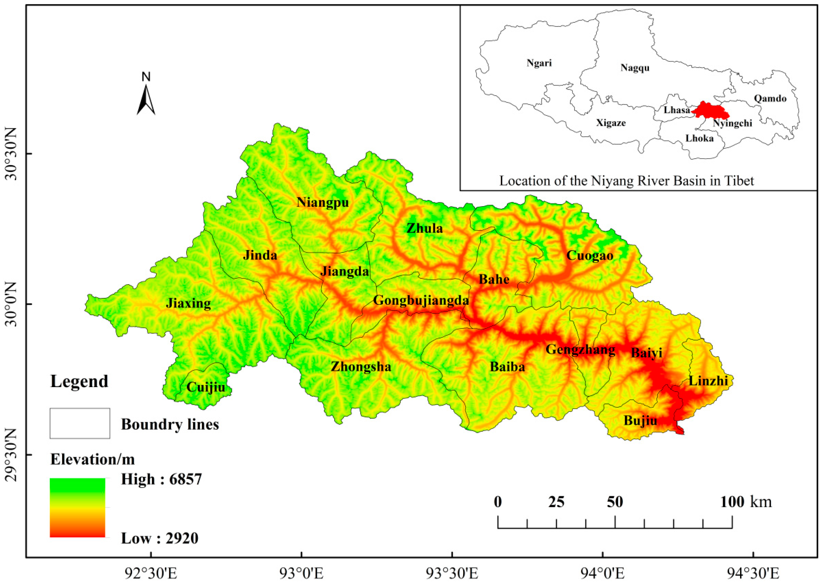
Figure 2.
Types of land use in the Niyang River Basin in 1990, 2000, 2010 and 2020.
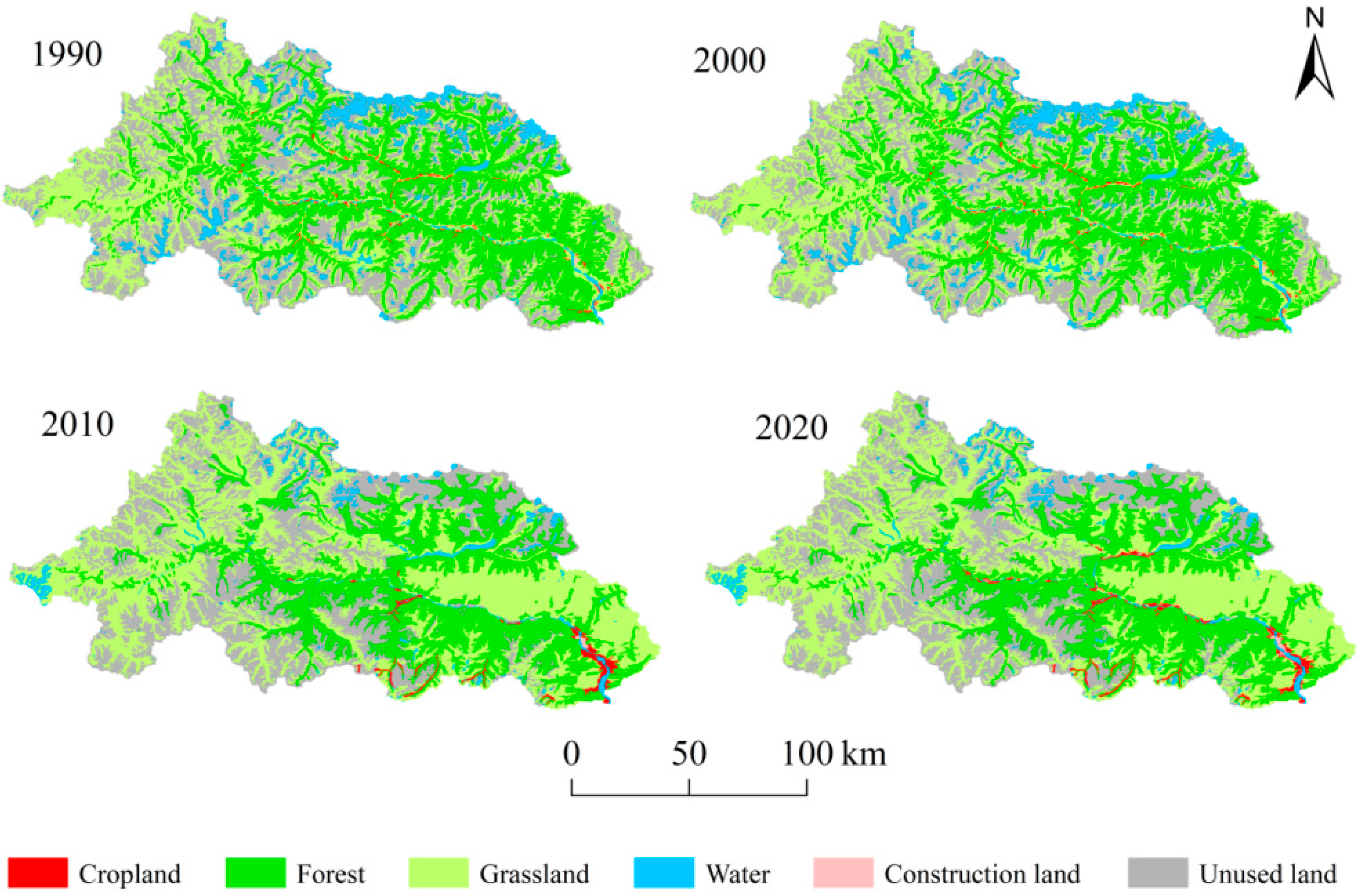
Figure 3.
Proportion changes of different land use types in the Niyang River Basin from 1990 to 2020.
Figure 3.
Proportion changes of different land use types in the Niyang River Basin from 1990 to 2020.
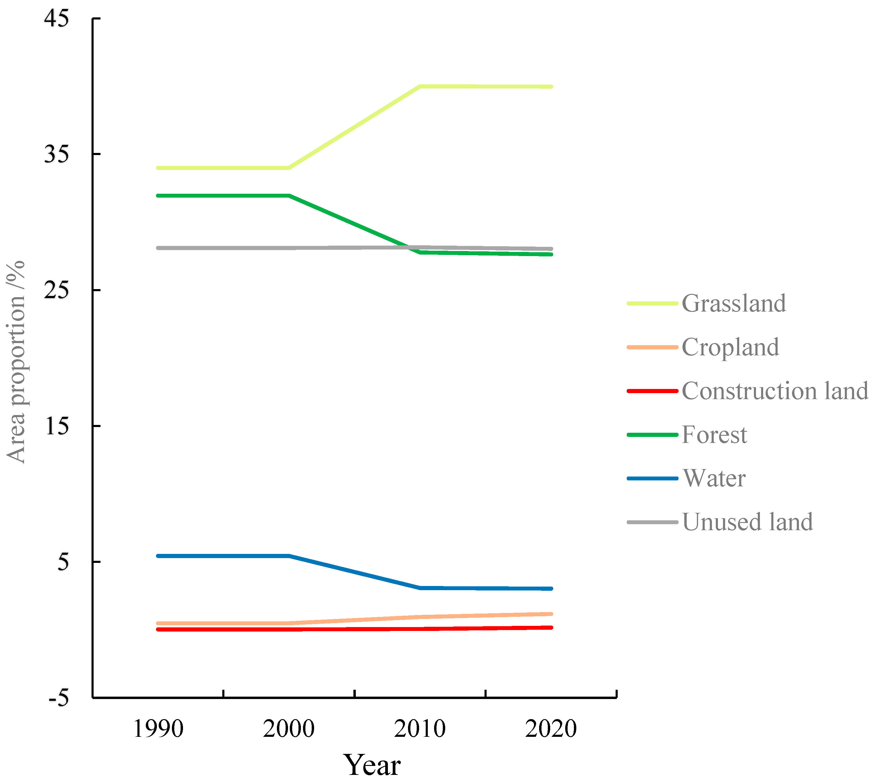
Figure 4.
Change of soil loss amount in the Niyang River Basin from 1990 to 2020.
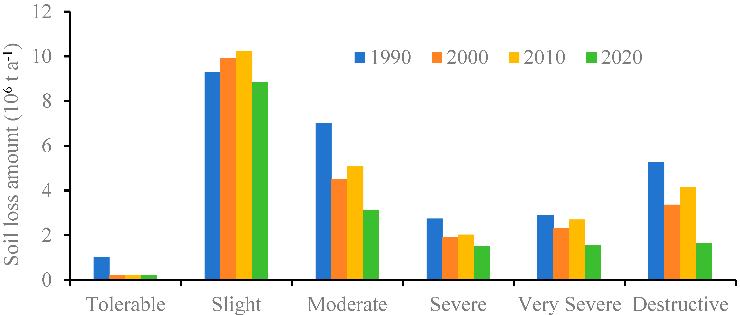
Figure 5.
Gradation of soil erosion in the Niyang River Basin in 1990, 2000, 2010 and 2020.
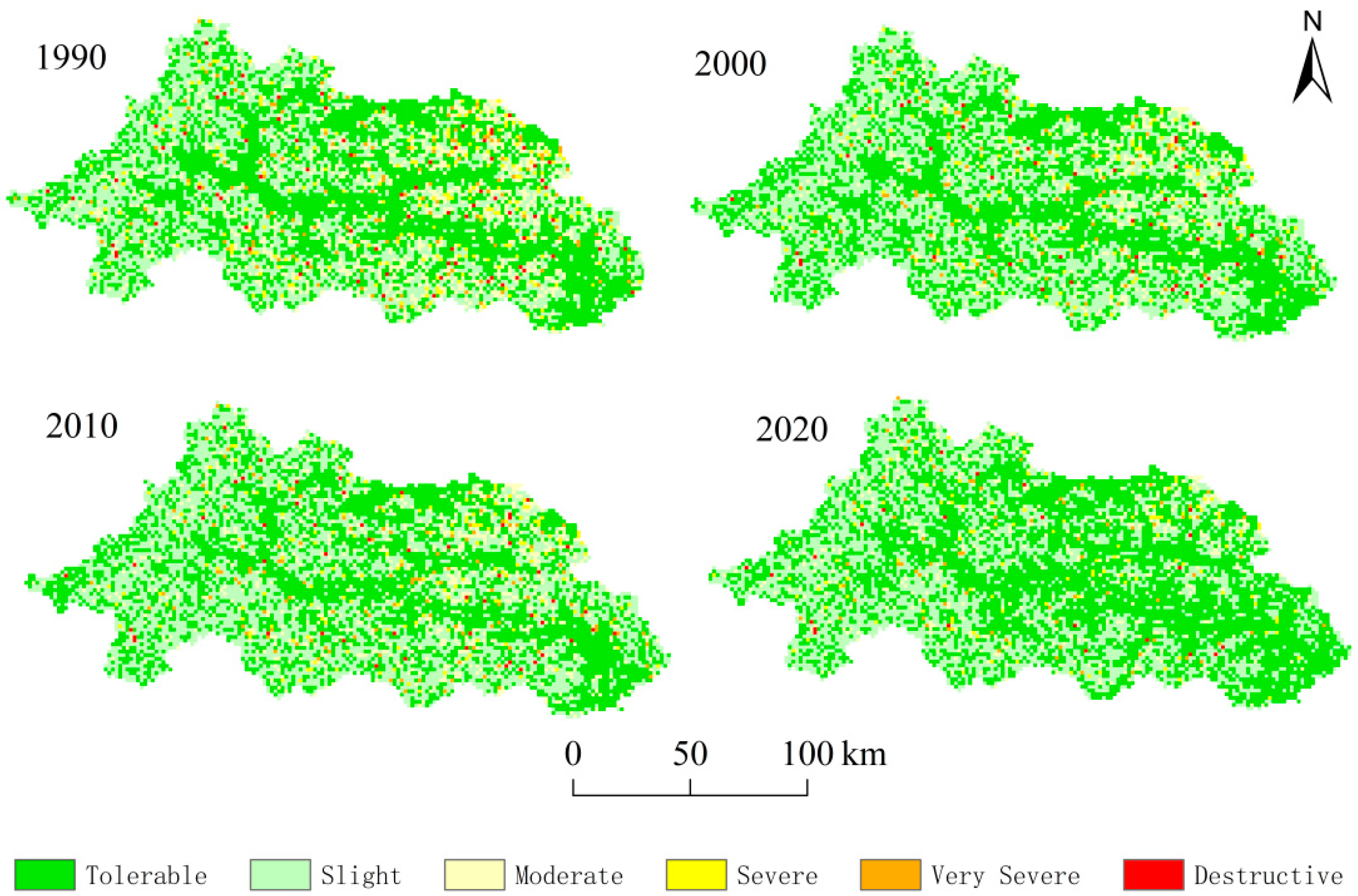
Figure 6.
Spatial change of soil erosion Gradation in the Niyang River Basin.


Table 1.
Classification criteria for soil erosion intensity (Unit: t km-2a-1).
| Gradation of Soil Erosion | Tolerable | Slight | Moderate | Severe | Very Severe | Destructive |
|---|---|---|---|---|---|---|
| thresholds | (0, 500] | (500, 2500] | (2500, 5000] | (5000, 8000] | (8000, 15000] | >150000 |
Table 2.
Area and proportion of land use types in the Niyang River Basin from 1990 to 2020.
| Land use types | 1990 | 2000 | 2010 | 2020 | ||||
|---|---|---|---|---|---|---|---|---|
| Area(km2) | Proportion(%) | Area(km2) | Proportion(%) | Area(km2) | Proportion(%) | Area(km2) | Proportion(%) | |
| Cropland | 84.60 | 0.48 | 84.51 | 0.48 | 166.47 | 0.94 | 206.51 | 1.16 |
| Forest | 5,621.13 | 31.61 | 5,620.26 | 31.60 | 4,886.64 | 27.48 | 4,861.62 | 27.34 |
| Grassland | 6,097.91 | 34.29 | 6,098.53 | 34.29 | 7,145.87 | 40.18 | 7,140.03 | 40.15 |
| Water | 946.87 | 5.32 | 946.82 | 5.32 | 531.88 | 2.99 | 523.87 | 2.95 |
| Construction land | 4.87 | 0.03 | 4.86 | 0.03 | 10.88 | 0.06 | 29.57 | 0.17 |
| Unused land | 5,027.79 | 28.27 | 5,028.20 | 28.28 | 5,041.44 | 28.35 | 5,021.59 | 28.24 |
Table 3.
Soil erosion modulus in the Niyang River Basin in different years (Unit: t km-2a-1).
| Types | 1990 | 2000 | 2010 | 2020 |
|---|---|---|---|---|
| Minimum | 0.00 | 0.00 | 0.00 | 0.00 |
| Maximum | 327,727 | 232,783.16 | 238,581.47 | 110,343.13 |
| Mean | 1,625.46 | 1,254.99 | 1,375.03 | 961.03 |
Table 4.
Area and proportion of soil erosion in the Niyang River Basin in 1990, 2000, 2010 and 2020.
Table 4.
Area and proportion of soil erosion in the Niyang River Basin in 1990, 2000, 2010 and 2020.
| Gradation of Soil Erosion | 1990 | 2000 | 2010 | 2020 | ||||
|---|---|---|---|---|---|---|---|---|
| Area(km2) | Proportion (%) |
Area(km2) | Proportion (%) |
Area(km2) | Proportion (%) |
Area(km2) | Proportion (%) |
|
| Tolerable | 8,253.65 | 47.24 | 8,082.02 | 46.24 | 7,769.40 | 44.47 | 9,253.75 | 53.35 |
| Slight | 6,211.61 | 35.55 | 7,574.83 | 43.34 | 7,652.67 | 43.80 | 6,825.89 | 39.35 |
| Moderate | 2,114.54 | 12.10 | 1,242.01 | 7.11 | 1,406.97 | 8.05 | 857.33 | 4.94 |
| Severe | 458.83 | 2.63 | 287.12 | 1.64 | 305.43 | 1.75 | 223.69 | 1.29 |
| Very Severe | 283.38 | 1.62 | 201.93 | 1.16 | 236.24 | 1.35 | 141.05 | 0.81 |
| Destructive | 150.99 | 0.86 | 88.88 | 0.51 | 102.34 | 0.59 | 42.87 | 0.25 |
Table 5.
Proportion of soil erosion class change types in the Niyang River Basin (Unit: %).
| Types of Change | 1990-2000 | 2000-2010 | 2010-2020 |
|---|---|---|---|
| weakened | 10.96 | 2.39 | 11.83 |
| unchanged | 86.25 | 92.74 | 85.93 |
| enhanced | 1.98 | 4.87 | 2.24 |
Table 6.
Proportion of soil erosion area in different land use types in the Niyang River Basin in 2020 (Unit: %).
Table 6.
Proportion of soil erosion area in different land use types in the Niyang River Basin in 2020 (Unit: %).
| Gradation of Soil Erosion | Grassland | Cropland | Construction land | Forest | Water | Unused land |
|---|---|---|---|---|---|---|
| Tolerable | 50.40 | 72.76 | 100 | 70.14 | 100 | 38.46 |
| Slight | 42.64 | 23.09 | 0.00 | 23.87 | 0.00 | 52.24 |
| Moderate | 4.60 | 2.18 | 0.00 | 3.67 | 0.00 | 6.87 |
| Severe | 1.34 | 1.49 | 0.00 | 1.07 | 0.00 | 1.41 |
| Very Severe | 0.72 | 0.48 | 0.00 | 0.96 | 0.00 | 0.87 |
| Destructive | 0.30 | 0.00 | 0.00 | 0.29 | 0.00 | 0.15 |
| The total | 100 | 100 | 100 | 100 | 100 | 100 |
Table 7.
Proportion of land use area in different soil erosion intensities in the Niyang River Basin in 2020 (Unit: %).
Table 7.
Proportion of land use area in different soil erosion intensities in the Niyang River Basin in 2020 (Unit: %).
| Land Use Types | Tolerable | Slight | Moderate | Severe | Very Severe | Destructive |
|---|---|---|---|---|---|---|
| Grassland | 37.85 | 43.48 | 37.53 | 41.97 | 35.19 | 49.51 |
| Cropland | 1.60 | 0.69 | 0.52 | 1.36 | 0.68 | 0.00 |
| Construction land | 0.27 | 0.00 | 0.00 | 0.00 | 0.00 | 0.00 |
| Forest | 36.88 | 18.04 | 20.91 | 23.30 | 33.18 | 31.47 |
| Water | 3.42 | 0.00 | 0.00 | 0.00 | 0.00 | 0.00 |
| Unused land | 19.98 | 37.79 | 41.04 | 33.37 | 30.95 | 19.02 |
| The total | 100 | 100 | 100 | 100 | 100 | 100 |
Table 8.
The total amount and proportion of soil loss in the Niyang River Basin in 1990, 2000, 2010 and 2020.
Table 8.
The total amount and proportion of soil loss in the Niyang River Basin in 1990, 2000, 2010 and 2020.
| Land Use Types | 1990 | 2000 | 2010 | 2020 | ||||
|---|---|---|---|---|---|---|---|---|
| Amount (Mt) |
Proportion (%) |
Amount (Mt) |
Proportion (%) |
Amount (Mt) |
Proportion (%) |
Amount (Mt) |
Proportion (%) |
|
| Grassland | 9.91 | 36.09 | 7.91 | 36.32 | 9.66 | 40.07 | 9.63 | 43.80 |
| Cropland | 0.01 | 0.04 | 0.04 | 0.20 | 0.14 | 0.57 | 0.16 | 0.71 |
| Forest | 10.01 | 36.43 | 8.26 | 37.94 | 8.21 | 34.04 | 6.83 | 31.06 |
| Unused land | 7.53 | 27.43 | 5.56 | 25.53 | 6.10 | 25.32 | 5.37 | 24.44 |
Table 9.
The proportion of soil erosion class change areas in land use change types in three phases (Unit: %).
Table 9.
The proportion of soil erosion class change areas in land use change types in three phases (Unit: %).
| Land Use Change Types | 1990-2000 | 2000-2010 | 2010-2020 | |||
|---|---|---|---|---|---|---|
| weakened | enhanced | weakened | enhanced | weakened | enhanced | |
| Unchanged grassland | 35.37 | 28.17 | 29.83 | 31.84 | 40.97 | 44.93 |
| Unchanged forest | 34.88 | 68.08 | 57.96 | 42.57 | 48.37 | 28.83 |
| Unchanged unused land | 29.51 | 3.13 | 11.56 | 24.42 | 9.26 | 18.20 |
| Unchanged cropland | 0.23 | 0.61 | 0.65 | 1.17 | 1.04 | 5.13 |
| Grassland to cropland | 0.00 | 0.00 | 0.00 | 0.00 | 0.04 | 0.52 |
| Cropland to grassland | 0.00 | 0.00 | 0.00 | 0.00 | 0.01 | 0.18 |
| Cropland to forest | 0.00 | 0.00 | 0.00 | 0.00 | 0.04 | 0.00 |
| Forest to grassland | 0.00 | 0.00 | 0.00 | 0.00 | 0.19 | 0.21 |
| Forest to cropland | 0.00 | 0.00 | 0.00 | 0.00 | 0.08 | 0.35 |
| Water to cropland | 0.00 | 0.00 | 0.00 | 0.00 | 0.00 | 1.51 |
| Water to forest | 0.00 | 0.00 | 0.00 | 0.00 | 0.00 | 0.01 |
| Unused land to cropland | 0.00 | 0.00 | 0.00 | 0.00 | 0.01 | 0.14 |
Disclaimer/Publisher’s Note: The statements, opinions and data contained in all publications are solely those of the individual author(s) and contributor(s) and not of MDPI and/or the editor(s). MDPI and/or the editor(s) disclaim responsibility for any injury to people or property resulting from any ideas, methods, instructions or products referred to in the content. |
© 2024 by the authors. Licensee MDPI, Basel, Switzerland. This article is an open access article distributed under the terms and conditions of the Creative Commons Attribution (CC BY) license (http://creativecommons.org/licenses/by/4.0/).
Copyright: This open access article is published under a Creative Commons CC BY 4.0 license, which permit the free download, distribution, and reuse, provided that the author and preprint are cited in any reuse.


