Submitted:
12 December 2023
Posted:
18 December 2023
You are already at the latest version
Abstract
Remote Sensing and Geographic Information System are recognized as crucial instruments for conducting geographical and geospatial research. RS and GIS technology was employed to assess the morphological Characteristics of the Kasura River Watershed situated within the Parbhani and Jalna Districts of Maharashtra, India. The entire drainage area of the Kasura River basin measures 490.13 square kilometers (km2). Various morphometric characteristic were calculated and examined, encompassing linear features such as stream number, stream order, mean stream length, stream length, and stream length ratio, areal attributes including elongation ratio, circularity ratio, form factor, constant of channel maintenance, drainage density and drainage texture and relief characteristics such as relief, relief ratio, maximum relief, ruggedness number, relative relief, and length of overland flow. These findings underscore the significance of employing morphometric analysis in watershed assessment, offering a quantitative method for characterizing the surface attributes of a drainage pattern and yielding valuable insights into the topography and runoff dynamics of the region.
Keywords:
Remote Sensing
; GIS
; Morphometric Analysis
; Kasura River Watershed
; Digital Elevation Model
INTRODUCTION
Remote Sensing is the process of acquiring information about an object, region, or phenomenon without the need for direct physical interaction. In contrast, a Geographical Information System primarily revolves around handling geographic data, which is analyzed, manipulated, and efficiently organized using computers to address real-world issues (Patra, 2015). The utilization of Remote Sensing techniques proves to be a convenient approach for conducting morphometric analysis. Satellite images offer a comprehensive overview of vast areas, making them highly valuable for examining the morphometry of drainage basins (Rai et al., 2014). Understanding the morphometric characteristics of the basin is crucial for gaining insights into a range of hydrological behaviors and processes. (Sarma et al., 2013). Different hydrological phenomena are linked to the physiographic attributes of a drainage basin, including factors like its size, shape, drainage area slope, drainage density, as well as the dimensions and lengths of its contributing elements. (Pande and Moharir, 2015). A comprehensive morphometric analysis of a basin proves invaluable for comprehending how the morphological aspects of drainage systems impact landforms and their distinguishing features. (Sreedevi, 2009). The application of morphometric and hypsometric analyses is a common approach for evaluating the drainage attributes of river basins. (Umrikar, 2016). The rapidly advancing field of Spatial Information Technology, along with Remote Sensing, Geographic Information Systems, and GPS, proves to be potent instruments for addressing a multitude of challenges in land and water resources planning and management. These modern techniques surpass conventional data processing methods in their effectiveness. (Rai et al., 2014). In the last twenty years, there has been a growing trend in obtaining this information from digital renditions of topography, commonly referred to as Digital Elevation Models (DEMs). In recent times, the automated calculation of drainage basin parameters has demonstrated efficiency, time-saving benefits, and represents an ideal utilization of GIS technology. (Sarma et al., 2013). In this current research, the aim was to analyze the morphometric features of the watersheds in the Maharashtra districts of Parbhani and Jalna using RS and GIS techniques.
MATERIALS AND METHODS
Study area
As shown in Figure 1, The study focuses on the Kasura River in Parbhani and Jalna districts, covering coordinates 76007’E to 76030’E longitude and 19021’N to 19030’N latitude, spanning 490.13 sq km. Emerging near Dudhana, it's part of the Purna River sub-basin with an 860 mm annual rainfall, the region mainly comprises black cotton soil, clay-like and deep black, originating from iron, lime, and magnesium-rich "Deccan trap" rock (basalt). Temperatures range from 32.50°C to 41.50°C. Monsoons (June-September) bring heavy rainfall.
Watershed delination
The process of watershed delineation holds significant importance within the realm of watershed management. (Singh, 2000). The ArcGIS 10.8 software facilitates watershed delineation through the utilization of Carto-DEM data. The resulting shapefile from the delineation process within the study area is subsequently employed to crop satellite images for subsequent analysis.
Morphological characteristics
The hydrologic analysis is greatly influenced by the physical attributes of the watershed, impacting the runoff traits. Morphological features including drainage density, channel length, stream order, channel slope, watershed dimensions, topography, soil attributes, geology, vegetation, climate and land use collectively contribute to comprehending the physical mechanisms operating within the watershed. (Singh, 2000).
The methodical description of the geometry of a watershed is called morphological characterisation. The following measurements were necessary due to the its stream channel system and drainage basin's geometry. (Singh, 2000):
- A.
- Linear aspect of the drainage network
- B.
- Areal aspect of the drainage basin
- C.
- Relief aspect of the channel network as well as contributing ground slopes
The morphometric characteristics of the watershed, along with the corresponding symbols and utilized formulas, are presented in Table 1.
RESULTS AND DISCUSSION
The morphometric characteristics of the Kasura river basin have undergone examination, with detailed outcomes outlined in Tables 2, 3, and 4. The values from the sub-basins were obtained using the calculate geometry tool within ArcGIS 10.8. The total drainage area of the Kasura River basin is 490.13 km2. The classification (Figure 4) has been used to rank the streams within the Kasura River Basin, which are then discussed in detail below. (Strahler’s, 1964)
A. Linear aspects of the drainage network: -
1. Stream order (u)
The research area's drainage network has been determined to have a drainage network up to a 5th - order basin by using this ordering procedure through GIS.
2. Stream number (Nu)
According to the data in Table no 2, there are 436, 91, 15, 2, and 1 stream of the first, second, third, fourth, and fifth orders in the watershed, respectively. The overall number of streams was shown to gradually decrease as the stream order increased. The drainage map for the catchment area around the Kasura River is shown in Figure 3.
Figure 3.
Slope Map of Kasura River Watershed.
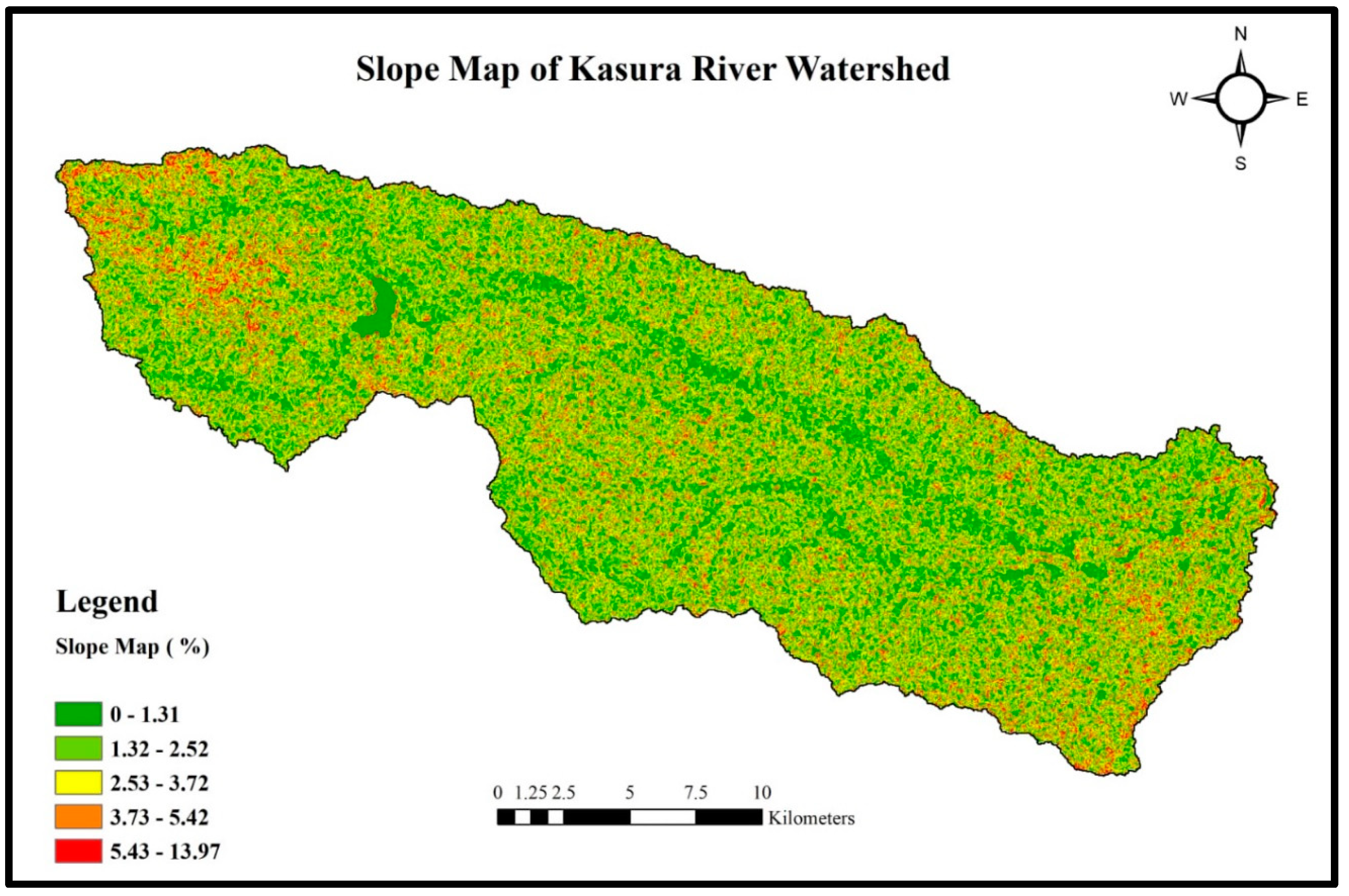
Figure 4.
Contour Map of Kasura River Watershed.

3. Bifurcation ratio (Rb)
According to the data in Table 2, The mean bifurcation ratio (Rb) for the watershed was determined to be 5.09. The watershed's mean Rb value indicates that geological formations do not interfere with the drainage pattern. The fact that Rb for the watershed was 5.09 indicates that geologic formations don’t have a significant impact on the drainage pattern (Chow, 1964).
4. Mean stream length (Lu)
According to the data in Table 2, it can be noticed that as the stream order increases, the average length of streams tends to decrease. This phenomenon could be attributed to various factors such as geomorphological, lithological, and structural influences, which may exhibit notable differences. (Strahler, 1964).
5. Stream length ratio (RL)
According to the data in Table 2, it can be noted that the average stream length of ratio for catchment was determined to be 0.4425. This ratio holds significance in its association with the discharge of surface water and the erosion level within the basin. It is influenced by the configuration of the watershed and the presence of shorter streams. Consequently, these watersheds are more susceptible to erosion. (Sreedevi et al., 2009)
B. Areal aspects of the drainage network
1. Form factor (Rf)
According to the data in Table 3, it was noted that the form factor for watersheds equaled 0.212. This ratio serves as an indicator of the shape of the watersheds. In all cases, this value suggests that the watersheds exhibit an elongated to sub-circular configuration. An elongated basin implies a flatter peak in flow. The form factor index shows an opposite relationship with the square of the axial length while displaying a direct connection with peak discharge (Horton's, 1945). Thus, it mitigates the impact of peak floods, it is imperative to establish soil conservation structures.
2. Circulatory ratio (Rc)
According to the data in Table 3, it was observed that the circulatory ratio for watersheds were 0.1679 respectively. These watersheds suggest that the basin has an elevated shape, has small runoff flow, and has highly permeable subsoil characteristics. The dimensionless circulatory ratio (Rc) represents the ratio of the basin's area to the area of a circle with an equivalent perimeter to that of the basin. It is noted that circulatory ratios typically fall within the range of 0.4 to 0.5, signifying the presence of strongly elongated and permeable homogeneous geological materials. The circulatory ratio (Rc) primarily relates to factors such as the slope geological formations, LULC, relief, climate and the frequency of streams and length of the basin. (Miller, 1953).
3. Elongation ratio (Re)
According to the data in Table 3, it can be observed that the elongation ratio for watershed values of the kasura river is 1.264, This suggests that the most significant part of the basin exhibits the highest relief. The Re is a crucial index used in the analysis of catchment shape. It represents the relationship between the diameter of a circle having an equivalent area to the drainage basin and the longest length of the river basin. This ratio provides valuable insights into the hydrological parameter of a drainage basin. This suggests that these areas are vulnerable to significant erosion and sedimentation loads. Additionally, it points to the presence of pronounced steep ground and relief slopes. (Rai et al., 2014).
4. Drainage Density (Dd)
According to the data in Table 3, it can be observed that the drainage density for watershed were 1.38 km-1, respectively. This parameter reflects the proximity of channel spacing within the entire basin, including its stream channels. In this particular watershed, the drainage density suggests the presence of less porous sub-surface materials, robust vegetation cover as well as significant relief. (Manjare et al., 2014).
5. Constant of channel maintenance (C)
According to the data in Table 3, it can be observed that the constant of channel maintenance for watersheds were 0.724, indicating that these watersheds exhibited higher values for this parameter, suggesting a lower drainage density. (Schumn, 1956).
6. Drainage texture (T)
According to the data in Table 3, it can be observed that drainage texture for watershed were 2.87 km-1 respectively. This characteristic represents the relative spacing of the drainage network. A drainage texture measuring less than 2 indicates an extremely coarse network, whereas values ranging between 2 as well as 4 signify a coarse network. If the value falls between 4 and 6, it indicates a moderate drainage network, whereas values between 6 and 8 suggest a fine drainage network. Anything above 8 signifies a very fine drainage texture. (Smith, 1950). Therefore, these watersheds have coarse drainage texture.
C. Relief aspects of the drainage network
1. Relief (H)
According to the data in Table 4, it is observed that the relief within the watersheds measures 0.04 km. Understanding the denudational characteristics of the basin heavily relies on the relief of the area (Sreedevi et al., 2009).
2. Maximum relief
According to the data in Table 4, it can be observed that the maximum relief for these catchments were 0.12 km, respectively.
3. Relief ratio (Rn)
According to the data in Table 4, it can be observed that relief ratio for these catchments were 0.4 km respectively. In hilly regions, high relief ratios are indicative of steep slopes and elevated terrain, whereas low values are associated with valley regions. (Sreedevi et al., 2009).
4. Relative relief (Rhp)
According to the data in Table 4, it can be observed that the relative relief for catchment were 0.21 %. Relative relief, often referred to as the "amplitude of available relief" or "local relief," is a morphometric parameter that quantifies the variation in elevation within a defined area. To calculate relative relief, you can find it by the ratio of the difference in elevation between the highest and lowest points in a basin (H) to the perimeter of that basin (P). In mathematical terms, this can be expressed as:
Relative relief = H/P.
The values obtained for relative relief are classified into three groups based on the data: (i) low relative relief, ranging from 0 meters to 100 meters, (ii) moderate relative relief, falling between 100 meters and 300 meters, and (iii) high relative relief, which is any value exceeding 300 meters. (Melton, 1958)
5. Ruggedness number (RN)
According to the data in Table 4, The catchment's ruggedness number was determined to be 0.552, indicating significant values for both variables, with a steep and extensive slope (Strahler 1956).
6. Length of overland flow (Lg)
According to the data in Table 4, it can be observed that the overland flow length for the catchment was observed to be 0.36 km. The important morphometric factors that influence the topographic as well as hydrological development of the drainage network is the length of the overland flow (Kumar, 2013) and a highest value for this characteristic indicate highest surface runoff (Manjiro et al., 2014).
CONCLUSION
In Conclusion, utilizing morphometric analysis for a catchment represents a quantitative approach for delineating the surface features of a drainage system, offering valuable insights into the topography and runoff patterns of the area. A greater bifurcation ratio signifies an elongated shape for the watershed, while a lower ratio suggests a more circular shape. In the varying stream lengths in the studied region result from diverse topography and slope discrepancies. The form factor for all catchment consistently suggests they exhibit shapes ranging from elongated too nearly circular. The circulatory ratio of 0.1679 signifies the inclination of small drainage basins within uniform geological materials to maintain geometric similarities. A high elongation ratio value suggests robust infiltration capabilities and minimal runoff conditions, while low elongation ratios indicate vulnerability to substantial erosion and sedimentation. When drainage density values are low, it suggests lower permeability, moderate to steep slopes, and increased surface runoff. Watersheds with a size of 0.04 km generally exhibited varying relief characteristics. Elevated relief ratios denoted hilly terrain with steep slopes, while lower values suggested valley regions. Furthermore, high length of the overland flows a value indicated significant surface runoff, while low value corresponded to the low surface runoff.
Acknowledgement
The authors express gratitude to the College of Agriculture Engineering and Technology, Parbhani, affiliated with Vasantarao Naik Marathwada Krishi Vidyapeeth (VNMKV), Parbhani. Additionally, Vipul S. Chaudhari extends thanks to NAHEP-CAAST, VNMKV, Parbhani, for granting access to the GIS lab facility used in this study.
References
- Abdulkareem, J. H., Pradhan, B., Sulaiman, W. N. A., & Jamil, N. R. (2018). Quantification of Runoff as Influenced by Morphometric Characteristics in a Rural Complex Catchment. Earth Systems and Environment, 2(1), 145–162. [CrossRef]
- Arulbalaji, P., & Padmalal, D. (2020). Sub-watershed Prioritization Based on Drainage Morphometric Analysis: A Case Study of Cauvery River Basin in South India. Journal of the Geological Society of India, 95(1), 25–35. [CrossRef]
- Chow, V. T., (1964). Handbook of Applied Hydrology. McGraw-Hill, New York: 14–18. [CrossRef]
- Horton, R. E. (1945). Erosional Development of Streams and their Drainage Density: Hydro Physical Approach to Quantitative Geomorphology. Bulletin of Geological Society of America. 56: 275-370.
- Krishnan, A., & Ramasamy, J. (2022). Morphometric assessment and prioritization of the South India Moyar river basin sub-watersheds using a geo-computational approach. Geology, Ecology, and Landscapes, 1–11. [CrossRef]
- Kumar Rai, P., Narayan Mishra, V., & Mohan, K. (2017). A study of morphometric evaluation of the Son basin, India using geospatial approach. Remote Sensing Applications: Society and Environment, 7, 9–20.
- Kumar, N. (2013). Morphometric Analysis of River Catchments Using Remote Sensing and GIS in case study of the Sukri River, Rajasthan. International Journal of Scientific and Research Publications. 3: 1-6.
- Mahala, A. (2020). The significance of morphometric analysis to understand the hydrological and morphological characteristics in two different morpho-climatic settings. Applied Water Science, 10(1), 33. [CrossRef]
- Mandale, V. P. (2016). Trend Analysis of Rainfall in Konkan Region of Maharashtra. Unpublished M. Tech. (Agril. Engg.) Thesis, College of Agricultural Engineering and Technology, Dr. Balasaheb Sawant Konkan Krishi Vidyapeeth, Dapoli, 14.
- Mangan, P., Haq, M. A., & Baral, P. (2019). Morphometric analysis of watershed using remote sensing and GIS—a case study of Nanganji River Basin in Tamil Nadu, India. Arabian Journal of Geosciences, 12(6), 202. [CrossRef]
- Manjare, B. S., Padhye M. A. and Girhe S. S. (2014). Morphometric Analysis of Lower.
- Miller, V. C. (1953). A Quantitative Geomorphology Study of Drainage Basin Characteristics in the Clinch Mountain Area, Virginia and Tennessee. Department of Geology, Columbia, Technical Report. 3.
- Mr, R., C, B., & Achyuthan, H. (2019). Quantitative analysis of the drainage and morphometric characteristics of the Palar River basin, Southern Peninsular India; using bAd calculator (bearing azimuth and drainage) and GIS. Geology, Ecology, and Landscapes, 3(4), 295–307. [CrossRef]
- Mundetia, N., Sharma, D., & Dubey, S. K. (2018). Morphometric assessment and sub-watershed prioritization of Khari River basin in semi-arid region of Rajasthan, India. Arabian Journal of Geosciences, 11(18), 530. [CrossRef]
- Pande, C. B. and Moharir K. (2015). GIS Based Quantitative Morphometric Analysis and its Consequences in Case Study from Shanur River Basin, Maharashtra India. Application of Water Science, 861-871.
- Patra, P. (2015). Remote Sensing and Geographical Information System. The Association for Geographical Studies, 1-28.
- Prakash, K., Rawat, D., Singh, S., Chaubey, K., Kanhaiya, S., & Mohanty, T. (2019). Morphometric analysis using SRTM and GIS in synergy with depiction: A case study of the Karmanasa River basin, North central India. Applied Water Science, 9(1), 13. [CrossRef]
- Rai P., Mohan K., Mishra S., Ahmad A. and Mishra V. N. (2014). A GIS-Based Approach in Drainage Morphometric Analysis of Kanhar River Basin, India. Application of Water Science, 217–232. [CrossRef]
- Vikhe, S. D. and Patil, K.A. (2015). Shape Morphometric Parameter Analysis of Basin Using Geographical Information System: A case study, National Conference Organized by Dept. of Geology, Deogiri College Aurangabad, sponsored by UGC Jan. 2015, pp. 124-129.
- Vikhe, S. D., and Patil, K.A. (2016). Morphometric Analysis of a Basin Using Remote Sensing and GIS- A Review, International Journal of Innovation Research in Science, Engineering and Technology (IJCIET), Vol. 7(3), pp. 329-336.
- Sarkar, D., Mondal, P., Sutradhar, S., & Sarkar, P. (2020). Morphometric Analysis Using SRTM-DEM and GIS of Nagar River Basin, Indo-Bangladesh Barind Tract. Journal of the Indian Society of Remote Sensing, 48(4), 597–614. [CrossRef]
- Sarma, P., Sarmah K., Chetri P. K. and Sarkar A. (2013). Geospatial Study on Morphometric Characterization of Umtrew River Basin of Meghalaya, India. International Journal of Water Resources and Environmental Engineering. 5(8): 489-498.
- Schumm, S. A. (1956). Evolution of Drainage Systems and Slopes in Badlands at Perth Amboy, New Jersey. Bulletin of Geological Society of America. 67: 597-646.
- Singh, R. V. (2000). Watershed Planning and Management. Yash Publication. 50-51.
- Singh, S. and Singh, M. C. (1997). Morphometric analysis of Kanhar river basin. National Geographical Journal of India. 43 (1): 31-43.
- Smith, G. H. (1939). The Morphometry of Ohio: The Average Slope of the Land. Annals of the American Association of the Geographers. 29: 94.
- Sreedevi, P. D., Owais S., Khan H. H. and Ahmed S. (2009). Morphometric Analysis of a Watershed of South India Using SRTM data and GIS. Journal Geological Society of India. Pp. 543-552. [CrossRef]
- Strahler, A. N. (1964). Quantitative Geomorphology of Drainage Basins and Channel Networks. In: V.T. Chow (Ed.), Handbook of Applied Hydrology. McGraw-Hill, New York. 39-76.
- Umrikar, B. N. (2016). Morphometric Analysis of Andhale Watershed, Taluka Mulshi, District Pune, India. Applied Water Science. 2231–2243. [CrossRef]
- Wardha River Sub Basin of Maharashtra, India Using ASTER DEM Data and GIS. Esri India User Conference, 1-13.
Figure 1.
Location of the study area map.
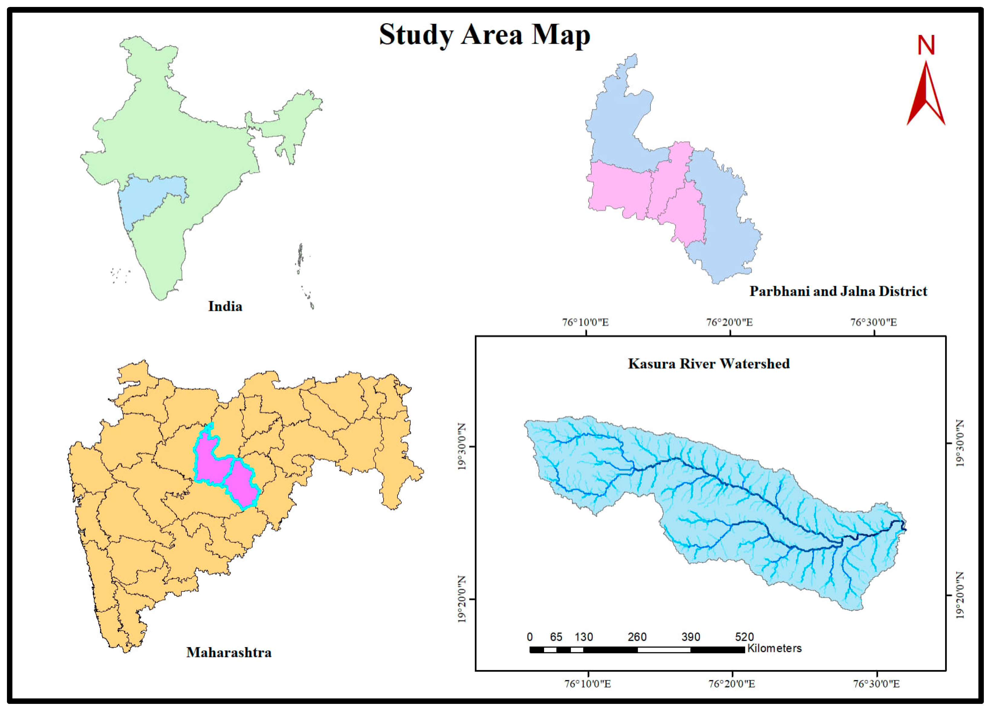
Figure 2.
Drainage Map of Kasura Watershed.
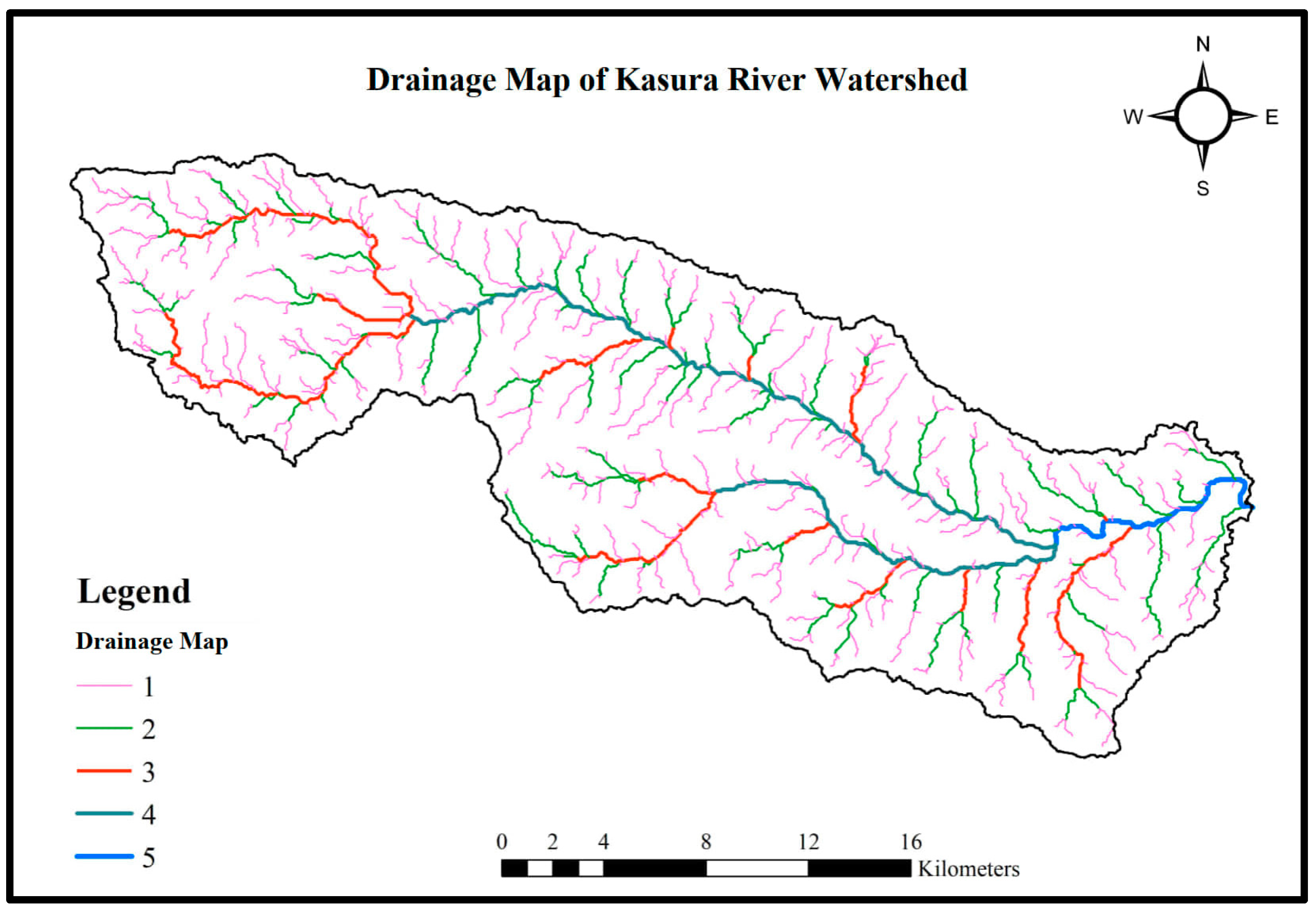

Table 1.
Morphometric parameters .
| Sr No |
Symbol | Morphometric Parameters |
Formulae | Particulars | Reference |
|---|---|---|---|---|---|
| |||||
| 1 | u | Stream order | Hierarchical Rank |
u = stream of order | Strahler, 1964 |
| 2 | Nu | Stream number | - | Nu = Number of streams order u | Strahler, 1964 |
| 3 | Rb | Bifurcation Ratio |
NRb = bifurcation ratiou u = number of streams of order u Nu+1 = number of streams of order u+1 |
Schumm, 1956 | |
| 4 | Mean Stream length |
= mean length of the channel order uLu = total length of a stream segments order u |
Hortan, 1945 | ||
| 5 | RL | Stream length ratio |
= mean length of the stream next lower order | Hortan, 1945 | |
| |||||
| 1 | Rf | Farm Factor | Au = basin of area Lb = basin of length |
Hortan, 1945 | |
| 2 | Rc | Circulatory ratio | AC = area of circle | Miller, 1953 | |
| 3 | Re | Elongation ratio | Dc = Circle diameter Lbm = length of maximum basin |
Schumm, 1956 | |
| 4 | Dd | Drainage density | L = Total length of the all-stream segments A = area of watershed |
Hortan, 1945 | |
| 5 | C | Constant of channel Maintenance | Dd = drainage density | Hortan, 1945 | |
| 6 | T | Drainage Texture | N = Total number of the streams P = Perimeter of basin |
Hortan, 1945 | |
| |||||
| 1 | H | Relief | H= Basin of Relief | Schumn, 1956 | |
| 2 | Hmax | Maximum relief | Hmax= Different Betn Highest and Lowest Point | Hmax = Maximum Relief | Schumn, 1956 |
| 3 | Rn | Relief ratio | H = basin relief Lh = horizontal distance |
Schumn,1956 | |
| 4 | Rhp | Relative relief | H = relief basin P = basin perimeter |
Schumn,1956 | |
| 5 | RN | Ruggedness number | RN = H × Dd | H= basin relief Dd = Drainage density of basin |
Strahler, 1964 |
| 6 | Lg | Length of the overland flow | Dd = Drainage density | Hortan, 1945 | |
Table 2.
Linear aspects of drainage network.
| Morphological Parameters |
Kasura River Watershed |
|---|---|
| Area (km2) | 490.13 |
| Perimeter (km) | 190.41 |
| Length of Basin (km) | 47.98 |
| Stream Order | |
| Ist Order | 436 |
| IInd Order | 91 |
| IIIrd Order | 15 |
| IVth Order | 2 |
| Vth Order | 1 |
| Total | 545 |
| Bifurcation Ratio | |
| Rb1 | 4.79 |
| Rb2 | 6.06 |
| Rb3 | 7.5 |
| Rb4 | 2 |
| Average | 5.09 |
| Stream Length (km) | |
| Lu1 | 378.00 |
| Lu2 | 159.00 |
| Lu3 | 80.00 |
| Lu4 | 49.00 |
| Lu5 | 12.00 |
| Total | 678.00 |
| Mean Stream Length (km) | |
| 0.87 | |
| 1.75 | |
| 5.33 | |
| 24.5 | |
| 12 | |
| Total | 44.45 |
| Stream Length Ratio | |
| RL1 | 0.42 |
| RL2 | 0.5 |
| RL3 | 0.61 |
| RL4 | 0.24 |
| Average | 0.4425 |
Table 3.
Areal aspects of drainage network.
| Areal Aspects | Kasura River Watershed |
|---|---|
| Basin Area (km2) | 490.13 |
| Form Factor | 0.212 |
| Circulatory Ratio | 0.1679 |
| Elongation Ratio | 1.264 |
| Drainage Density (km-1) | 1.38 |
| Constant of Channel Maintenance(km2 km-1) | 0.724 |
| Drainage Texture (km-1) | 2.87 |
Table 4.
Relief aspects of drainage network.
| Relief Aspects | Kasura River Watershed |
|---|---|
| Relief (km) | 0.4 |
| Maximum Relief (km) | 0.12 |
| Relief Ratio | 0.4 |
| Relative Relief (%) | 0.21 |
| Ruggedness number | 0.552 |
| Length of overland flow (km) | 0.36 |
Disclaimer/Publisher’s Note: The statements, opinions and data contained in all publications are solely those of the individual author(s) and contributor(s) and not of MDPI and/or the editor(s). MDPI and/or the editor(s) disclaim responsibility for any injury to people or property resulting from any ideas, methods, instructions or products referred to in the content. |
© 2023 by the authors. Licensee MDPI, Basel, Switzerland. This article is an open access article distributed under the terms and conditions of the Creative Commons Attribution (CC BY) license (http://creativecommons.org/licenses/by/4.0/).
Copyright: This open access article is published under a Creative Commons CC BY 4.0 license, which permit the free download, distribution, and reuse, provided that the author and preprint are cited in any reuse.


