Submitted:
29 November 2023
Posted:
05 December 2023
You are already at the latest version
Abstract
Sustained water management requires quantitative information and the knowledge of spatiotemporal dynamics of hydrological system within the basin. This can be achieved through the research. Several studies have investigated both surface water and groundwater in Beterou catchment. However, there are few published papers on the application of the SWAT modeling in Beterou catchment. The objective of this study was to evaluate the performance of SWAT to simulate the water balance within the watershed. The inputs data consist of digital elevation model, land use maps, soil map, climatic data and discharge records. The model was calibrated and validated using the Sequential Uncertainty Fitting (SUFI2) approach. The calibrated started from 1989 to 2006 with four years warming up period (1985-1988); and validation was from 2007 to 2020. The goodness of the model was assessed using five indices, i.e., Nash–Sutcliffe efficiency (NSE), the ratio of the root means square error to the standard deviation of measured data (RSR), percent bias (PBIAS), the coefficient of determination (R²), and Kling Gupta efficiency (KGE). Results showed that SWAT model successfully simulated river flow in Beterou catchment with NSE = 0.79, R2 = 0.80 and KGE= 0.83 for the calibration process against validation process that provides NSE = 0.78, R2 = 0.78 and KGE= 0.85 using site-based streamflow data. The relative error (PBIAS) ranges from -12.2% to 3.1%. The parameters runoff curve number (CN2), Moist Bulk Density (SOL_BD), Base Flow Alpha Factor (ALPHA_BF), and the available water capacity of the soil layer (SOL_AWC) were the most sensitive parameter. The study provides further research with uncertainty analysis and recommendations for model improvement and provision of an efficient means to improve rainfall and discharges measurement data.
Keywords:
Watershed
; water balance
; SWAT modelling
; Beterou
1. Introduction
The importance of water to human existence cannot be overstated. It remains pivotal in our daily life, playing an indispensable role in sectors such as food and energy production, industry, and domestic use. Access to improved water and sanitation is integral to accomplishing the Sustainable Development Goals (SDGs) [3]. Unfortunately, water scarcity is a pressing issue, with rapid population growth being one of the primary underlying causes. As the population increases, the demand for water intensifies, spanning various sectors, including food production, energy generation, industrial applications, and domestic use [1].
Moreover, the added complexity of climate change poses a new layer of uncertainty regarding freshwater availability [2], which further compounds the challenges faced by sectors like agriculture and energy [4]. Research indicates that a significant portion of the global population is projected to face severe water scarcity in the 21st century. This problem is particularly acute in regions like West Africa, which have experienced prolonged droughts over the past three decades [5]. Benin, a country in West Africa, is no exception to this global water crisis. Although it has an annual freshwater availability estimated at around 4000 m3 per capita, water scarcity still occurs at the local level, particularly at the end of the dry season [6]. These fluctuations in freshwater supplies create significant challenges for water managers in the region. Therefore, having accurate knowledge of freshwater availability is imperative for effective water resource management at both regional and national levels. This knowledge is crucial for devising water management strategies that can mitigate the uncertainties brought by climate variations and population growth.
Understanding the relationship between the water cycle and watersheds is crucial to address these challenges. In Benin, the lack of local-level observed data for water resource planning has made hydrologic simulations a popular method. Various models have been applied to the Ouémé sub-catchment, such as the Génie Rural à 4 paramètres Journalier (GR4J) model [7], Universal Hydrological Program Hydrological Response Unit is a conceptual semi-distributed model (UHP-HRU) [8,9]; Planner Oriented evaluative Watershed model for Environmental and socio-economic Responses (POWER) [10]; and Water Balance Simulation Model (WaSiM) [11]. Biao [12] highlighted the effectiveness of the Hydrological Model based on the Least Action Principle (HyMoLAP) model in the Oueme River basin, while Getirana et al. [13] found Land Surface Models unsuitable for the region. Other models like Model for Sustainable Development of Water Resources (MOSDEW)[14] and Modular Three-Dimentional Finite-Difference Groundwater Flow Model (MODFLOW) were used by Gaiser et al [15] to investigate the hydrological balance over Oueme River.
This study centers on the Beterou catchment, located in the upper Oueme River basin in Benin. Researchers have employed various hydrological models to simulate the basin's hydrological cycle and predict potential impacts of climate change. For example, Le Lay [16] employed the GR4J model in the Oueme Supérieur watersheds at Beterou (10,070 km2), achieving satisfactory calibration with a Nash efficiency of 0.82. However, disparities were observed in simulated evapotranspiration and groundwater recharge compared to on-site measurements. In the quest for a more pertinent hydrological model for the region, Le Lay [17], Metardier [18], and Zannou [19] applied the Topography based Hydrological models (TOPMODEL) to the Upper Oueme watersheds at Beterou. While the model effectively reproduced streamflow, it fell short in representing evapotranspiration and groundwater recharge, critical factors in the genesis of flow in the study area. Subsequent research by Richard et al. [20] introduced the Hydrus 2D model to enhance TOPMODEL's representation of hydrological processes, especially in estimating evapotranspiration and groundwater recharge.
Despite agreement in streamflow simulations among various hydrological and Soil-Vegetation-Atmosphere Transfer (SVAT) model used in the upper Oueme catchment, substantial disparities emerged in terms of evapotranspiration and groundwater storage, as emphasized in Peugeot et al. [21] study. To address these knowledge gaps in the hydrological functioning of the Donga catchment, a model like Hydrus 2D, incorporating a deep infiltration term, was employed by Richard et al. [20] to refine the TOPMODEL. The results of this study demonstrated that the introduction of deep infiltration data alleviated the uncertainties linked to the TOPMODEL when estimating evapotranspiration and groundwater recharge within the specified watershed [20].
While several models have undergone testing in other region, the effectiveness of the SWAT model in simulating the hydrological balance within the Beterou catchment remains unexplored in the existing literature. This study's primary objective is to evaluate the robustness of the SWAT model in estimating hydrological processes within the study area. Specific objectives include conducting sensitivity analyses, assessing model goodness, and estimating the water balance in the selected watershed. SWAT was chosen for its suitability in large river basin scales, ease of use in simulating hydrological balance, and ability to represent surface and groundwater system interactions. Studies have demonstrated SWAT's performance in data-scarce regions, making it a preferred choice over models like TOPMODEL [22]; or WASIM [23]. A comparative analysis of hydrological models in evaluating water resources within a region with limited data in the Upper Blue Nile River Basin concluded that the SWAT model outperformed others in simulating flows in the Ribb watershed [24]. Other applications of SWAT have also been reported in the literature [25,26,27]. This study contributes to the existing literature by evaluating SWAT's effectiveness in simulating hydrological processes within the Beterou catchment, providing valuable insights for water resource management in the region.
2. Materials and Methods
2.1. Study area description
The Oueme River basin, the largest in the Republic of Benin, encompasses approximately 50,000 square kilometers at its Bonou outlet. This expansive basin is divided into two distinct sections: the upper and lower Oueme valleys, as identified by Anthony et al. [28]. However, for the purpose of this study, we focus on the upper Ouémé catchment at the Bétérou outlet, situated in the northern reaches of Benin (Figure 1).
This particular catchment boasts a unique geographic positioning, lying between latitudes 9°12' and 10°12' North and longitudes 1°30' to 3° East. Its geographical features provide a fascinating backdrop for environmental research and study.
Climatically, the upper Ouémé catchment is part of the Soudanese savanna zone (Figure 2), a region characterized by distinct wet and dry seasons. The rainy season unfolds in a unimodal pattern, typically spanning from April to October each year, with the zenith of precipitation occurring in August. Over the years 1998 to 2017, the average yearly temperature ranged between 25°C and 30°C, with an annual rainfall variation between 900 mm and 1,200 mm, as reported by Olofintoye et al. [29].
The river dynamics within this catchment exhibit pronounced seasonality, with high flow rates during the rainy season. The Bétérou hydrometric station records an average discharge of approximately 50 cubic meters per second (m3/s) from 1960 to 2015, as documented by Lawin et al. [30]. This seasonal ebb and flow in river discharge significantly impacts the ecosystem and land use within the catchment.
The upper Ouémé catchment's natural vegetation is characterized by a diverse landscape that includes forests, wooded savanna, and a mosaic of woodlands and grassy savannah [31]. However, this unique environment is under threat due to factors such as logging and land clearance for agricultural expansion, as observed by Cerget [32]. These environmental pressures have consequences for the biodiversity and ecological stability of the region.
In terms of agriculture, the catchment's inhabitants primarily engage in small-scale farming, featuring periodic fallow practices. The staple crops cultivated in this area include yams, cassava, maize, millet, and peanuts, as reported by Judex and Menz [33], and Klein and Roechrig [34]. Agriculture plays a crucial role in the local economy and sustenance of the population, making it an integral aspect of the catchment's socio-environmental landscape.
2.2. Input data
The dataset used for this study was broadly categorized into two types: spatial and non-spatial. The non-spatial data encompassed various environmental parameters. These included recorded daily rainfall, wind speed, solar radiation, relative humidity, and temperature. These specific data sets were procured from a reliable source, the Benin National Meteorological.
Furthermore, monthly discharge data played a pivotal role in our research. It was generously provided by the National Water Office, known locally as the Direction Générale de l’Eau (DGEau). Specifically, the monthly discharge data from the hydrometric station of Beterou was employed for both the calibration and validation of our model.
The spatial data used in this study is depicted in the maps shown in Figure 3. The soil map of the study region is illustrated in Figure 3a. This map was sourced from the National Institute of Agronomic Research of Benin (INRAB)and the Laboratory of Hydraulics and Control of Water (LHME). The land use maps (as seen in Figure 3c) were extracted from a renowned source the RIVERTWIN (A Regional Model for Integrated Water Management in Twinned River Basins) project at a scale of 1/200,000 with 30 m of resolution. Another vital piece of spatial data is the 90 x 90 m resolution topographical data, showcased in Figure 3b. This data, crucial for this study, was extracted from the Shuttle Radar Topography Mission (SRTM) website. The provided Digital Elevation Model (DEM) became instrumental in delineating the watershed, resulting in the generation of 27 sub-watersheds covering the entire basin area, as visualized in Figure 3d. Furthermore, the DEM allowed us to evaluate topographic parameters. These included metrics such as terrain slope, channel slope, and reach length. Table 1 and Figure 4 offer a more granulated view, detailing the distribution of land use and soil across the chosen watershed.
Where AGRL: agriculture; URBN: Residential; RNGB: range brush; RNGE: range grasses; WATR: water; FRST: Forest-mixed; ORCD: Orchard; FRSE: Forest-evergreen, FRSD: Forest-deciduous.
2.3. SWAT model development
The Bétérou basin served as the focal point of this hydrological modeling study. To understand and map the hydrological dynamics of the area, a Digital Elevation Model (DEM) was employed. Using the DEM, the entire watershed was segmented into smaller, more manageable units, known as sub-basins. For each of these sub-basins, a set of hydrological properties, including flow direction and flow accumulation, were meticulously determined.
Outlet identification is a pivotal aspect of the hydrological modeling process. This is essentially a designated point within the watershed where all the water is expected to flow out. For the Bétérou basin study, an outlet was appropriately positioned and integrated into the model. A total of 27 sub-basins were created within the Bétérou basin. Sub-basins are typically used to segment the watershed for more detailed analysis, as different parts of the watershed may have varying characteristics that influence hydrology.
New soil characteristic data was integrated into the existing SWAT2012.mdb database. Accurate and up-to-date soil information is imperative for modeling the movement of water throughout the landscape. The sub-basins were overlaid with land use, soil maps, and slope characteristics to create 220 Hydrological Response Units (HRUs) [35]. HRUs are used to group areas with similar characteristics that affect hydrology, such as land use, soil type, and slope. To estimate the runoff resulting from daily rainfall, the Curve Number (CN) method was employed. This method calculates runoff based on localized factors, such as land use, soil type, and slope. The CN method is a widely adopted approach for quantifying runoff in hydrological modeling. Potential evapotranspiration (PET) represents the maximum amount of water that could be lost through evaporation and transpiration. Instead of choosing the widely method used like a Penman–Monteith method for PET estimation, in this study, the Hargreaves s method was selected as the preferred approach because it contributes to the reduction of ecexiceve water yield and surface runoff that have been observed within the catchment. Lastly, to map the flow of water within the basin's channels, the Muskingum method was adopted. This method offers an effective means to estimate channel water flow, a crucial aspect of any hydrological study.
2.4. Calibration and validation of the model
The simulation utilized the Sequential Uncertainty Fitting version 2 (SUFI-2) feature of SWAT-CUP from 1985 to 2020, as described by Abbaspour [36]. Notably, the year from 1985 to 1988 was designated as a warm-up period, involving fictitious data, to optimize the simulation's duration.
To configure the model's parameters effectively, the discharge data was partitioned into two distinct segments. The first portion was dedicated to model calibration, covering the years 1989 to 2006, while the second segment was reserved for the critical task of validating the model, encompassing the years 2007 to 2020.
In pursuit of identifying the parameters that most significantly influenced the model outcomes, a comprehensive sensitivity analysis was conducted. This analysis involved the selection of twelve SWAT parameters, drawn from previous studies (specifically, Degan et al. [37] and the SWAT documentation (Neitsch et al. [38]). The selected parameters encompassed a wide range of hydrological factors, including runoff curve number II (CN2), soil available water capacity (SOL_AWC), base flow alpha factor (ALPHA_BF), and groundwater revap coefficient (GW_REVAP). Other parameters considered were the deep aquifer percolation coefficient (RECHRG_DP), threshold depth for 'revap' in the shallow aquifer (REVAPMN), water delay (GW_DELAY), Manning’s “n” value for overland flow (OV_N), average slope steepness (HRU_SLP), the Saturated hydraulic conductivity (SOL_K (1)), USLE equation support practice factor (USLE_P.mgt) and SLSUBBSN, which is the average slope length.
A meticulous sensitivity analysis was undertaken. Each parameter was tested individually over 200 simulation iterations in SWAT-CUP to assess the influence of parameter range variations on the model outcomes. A second global sensitivity analysis (GSA) was performed at the end of the calibration phase to identify the parameters most sensitive to hydrological processes in the basin. Adjustments were made to the parameter values to find an optimal range suited to the research area. Following this, calibration was initiated using the identified sensitive parameters. Once a satisfactory calibration was achieved, the model was validated under the same parameter conditions.
2.5. Model performance evaluation
The evaluation of the simulated flow from the SWAT model was juxtaposed with observed data flow, which was gathered from the water control stations. To ensure a comprehensive comparison, five renowned statistical indicators were employed. These included the Nash–Sutcliffe efficiency (NSE), percent bias (PBIAS), the ratio of the root means square error to the standard deviation of measured data (RSR), and the coefficient of determination (R²) [39,40,41]. Another critical metric that was incorporated into the evaluation process was the Kling Gupta efficiency (KGE) [42,43,44,45]. The uniqueness of the KGE lies in its ability to approach model calibration from a multi-faceted perspective. In essence, it considers multiple objectives, such as correlation, flow variability error, and bias error, during the calibration phase.
The primary function of R² is to quantify the fraction of the observed data's total variance that the model can explain. Its values can range between 0.0 and 1.0. A higher R² value signifies a stronger agreement between the observed and simulated data, indicating a model's better predictive capability. The computation of the R² value can be done using Equation (1).
The Nash-Sutcliffe Efficiency (NSE) is a widely used statistic for assessing the performance of hydrological or environmental models, particularly in the context of hydrology and water resources management. NSE quantifies the relative magnitude of the residual variance (the variance of the model's errors) compared to the variance of the measured data. It provides a measure of how well a model fits observed data, with values typically ranging from negative infinity to 1, where 1 indicates a perfect match between the model and observed data, and values closer to 1 are considered better model fits. The formula for calculating NSE (Equation (2)) is as follows:
Percentage Bias (PBIAS) is a statistic used to assess the tendency of simulated data to be greater or smaller than observed data over a simulation period. PBIAS helps measure the bias or systematic overestimation or underestimation of a model's predictions compared to the observed data. It is expressed as a percentage, and the closer its value is to 0%, the better the model's simulation performance.
- If PBIAS is 0%, it indicates that the model's predictions are, on average, neither overestimating nor underestimating the observed data. This is the ideal outcome.
- If PBIAS is positive, it means the model tends to overestimate the observed data.
- If PBIAS is negative, it means the model tends to underestimate the observed data.
The formula for calculating PBIAS (Equation (3)) is as follows:
RSR is expressed as the ratio of the root mean square error (RMSE) and the standard deviation of observed flow (Oi). It is commonly accepted that the lower the RMSE the better the model performance. RSR varies from the optimal value of 0, which indicates zero residual variation and therefore shows the perfect model simulation, to a large positive value that indicates poorer model performance [77]. RSR is calculated using Equation
The Kling–Gupta efficiency (KGE) is widely used for model calibration and evaluation. It computed using Equation (5).
In Equations (1)– (5), Oi represents the measured flow, Ui represents the simulated flow, Ō represents the mean of the measured flow, Ū represents the mean of the stimulated flow, r represents the linear regression coefficient between the simulated and measured flow, and where Uu and UO are means od simulated and measured data respectively while σu and σo are the standard deviation of simulated and measured data. The methodology framework adopted for this study is presented in Figure 5.
3. Results
3.1. Sensitivity Analysis in Hydrological Simulation Using SWAT
Several research studies have emphasized the importance of hydrological simulation using the Soil and Water Assessment Tool (SWAT) To gain a deeper understanding of the system's dynamics, sensitivity analysis becomes crucial. For this study, twelve significant parameters have been identified, which are consistent with earlier research and the SWAT's documentation [37,38].
Utilizing the SWATCUP, each parameter was subjected to individual sensitivity analysis. This is presented in Table 2. The sensitivity of each parameter was evaluated based on the t-statistics and p-values. A higher absolute value of t-statistics paired with a lower p-value indicates a more sensitive parameter. Practically, a p-value nearing zero a parameter's heightened sensitivity for the specific analysis. The results of the sensitivity assessment revealed that the following parameters played a significant role in the Beterou Basin's hydrological behavior are: CN2, SOL_AWC, ALPHA_BF, RECHRG_DP, OV_N, HRU_SLP.hru, SOL_BD, USLE_P.mgt, SOL_K (1).sol and GW_DELAY. Specifically, CN2, and SOL_AWC had a substantial influence on the peak flow simulation in the basin. Parameters such as ALPHA_BF, RCHRG_DP.gw, GW_DELAY, and HRU_SLP.hru were found to predominantly affect the baseflow, which represents the water retention in the aquifer, and the parameter soil hydraulic conductivity (SOL_K), that is a soil hydraulic conductivity plays a key role in the movement of water in soil profiles, had an effect on runoff. The moist bulk density parameter (SOL_BD) plays a dual role by affecting both baseflow and evapotranspiration. Interestingly, no clear relationships were found between the flow and other parameters like OV_N, USLE_P. This underscores the complexity of hydrological processes in the basin.
Following the initial sensitivity analysis, a second global sensitivity analysis (GSA) was performed at the end of the calibration phase, where the Nash-Sutcliffe Efficiency (NSE)= 0.79 and R-squared (R2) values were 0.80. This analysis revealed that the average slope steepness (HRU_SLP), available water capacity of the soil layer (SOL_AWC), a moist bulk density (SOL_BD), CN2 and ALPHA_BF were the most sensitive parameters (Figure 6).
For the validation period, with NSE and R2 values of 0.78 respectively, the parameters with the highest sensitivity were found to be the available water capacity of the soil layer, the moist bulk density (SOL_BD), the base flow alpha factor (ALPHA_BF), water delay (GW_DELAY), available water capacity of the soil layer (SOL_AWC), soil hydraulic conductivity (SOL_K), and runoff curve number (CN2) (see Figure 7).
It's noteworthy that a significant portion of the calibrated and validated parameters were related to groundwater. This highlights the vital role that the interaction between surface and groundwater plays in shaping the overall hydrodynamics of the watershed.
3.2. Evaluation of Model Performance
To ensure the accuracy of our model, an extensive calibration and parameter correction effort was undertaken, leveraging the versatile SWAT-CUP software. This iterative process was aimed at generating results that closely aligned with observed data. Initially, SWAT was run with various parameter combinations. Subsequently, the calibrated parameters were meticulously adjusted until the simulated outcomes exhibited a notable resemblance to the observed values, as quantified by the Nash-Sutcliffe Efficiency (NSE) coefficient, which was expected to exceed 0.5.
The results of this comprehensive evaluation are presented in Table 3, which showcases critical model performance statistics, including the coefficient of determination (R2), NSE, RSR, the Kling-Gupta Efficiency (KGE), and PBIAS.
The values displayed in Table 3 affirm that the model's performance met the predefined standards. However, it's worth noting that during the validation period, the performance indices exhibited values slightly lower than those obtained during the calibration phase. This variance can be attributed to the inherent limitation of the calibration process, which optimizes simulation parameters solely within the calibration period. Several studies [46,47,48] have also observed similar trends in hydrological modeling. Figure 8 and Figure 9 provide a comparative view of the best simulated results juxtaposed against the observed time series of flow. These figures distinctly outline the performance of our model during both the calibration and validation periods.
3.3. Water Balance Simulated by the Soil and Water Assessment Tool (SWAT)
Figure 12 and Figure 13, present the comprehensive water balance analysis conducted by the SWAT model within the study area during the calibration and validation process. This figure offers a visual representation of the distribution of various water balance components that play a vital role in the hydrological dynamics of the catchment. These components include precipitation (P), actual evapotranspiration (AET), surface runoff, lateral flow, and groundwater recharge.
The annual average precipitation across the entire basin varies between 1120 and 1143.5 mm. Approximately 70-74% of the total precipitation within the basin is absorbed by the ecosystem through actual evapotranspiration (AET), highlighting the substantial loss of water through this process. In contrast, a smaller proportion of the precipitation, around 10-12%, is converted into surface runoff, while an even smaller percentage, merely 3%, is channeled into lateral flow. A relatively higher proportion, around 12-15%, is directed toward groundwater recharge, replenishing underground aquifers.
Notably, among these water balance components, actual evapotranspiration stands out with the highest percentage, underlining its dominance in the overall water budget of the catchment. On the other end of the spectrum, lateral flow registers the lowest percentage at a mere 3%, indicating its relatively minimal contribution to the river flow. This finding underscores the limited role of lateral flow in shaping the hydrological dynamics of the area. Furthermore, it's worth mentioning that the water balance estimated during the calibration matched well with the validation results. These results highlighted the rigorous robust performance of the SWAT to simulate the water balance within the Beterou catchment.
4. Discussion
4.1. Sensitivity Analysis
The precise identification of key parameters is pivotal for achieving an accurate streamflow simulation. To achieved this, a comprehensive global sensitivity analysis was conducted using the SWAT-CUP tool.
Notably, the results of this study have pinpointed CN2 (Runoff Curve Number), and SOL_AWC (Available Water Capacity of the Soil Layer) as the parameters with the most substantial influence on peak flow. These findings aligned with those obtained by Dègan et al. [37]. Furthermore, there is a notable congruence with the work of Kofidou and Gemitzi [49] in the Vosvozis River Basin (VRB) in Northeast Greece. In their study, they calibrated and validated the SWAT model using river flow measurements and satellite-based soil moisture. Their results similarly underscored the significance of parameters such as SOL_AWC, and CN2 in influencing peak flow within the VRB.
In addition to these two parameters, the study identified sept other parameters linked to streamflow simulation, namely SOL_BD (Moist Bulk Density), ALPHA_BF (Base Flow Alpha Factor), GW_DELAY (Water Delay in Groundwater Recharge), OV_N (Manning's N for Overland Flow), RCHRG_DP.gw (Groundwater Recharge Recession Constant), GW_DELAY (Water Delay in Groundwater Flow), SOL_K and HRU_SLP.hru (Average Slope Steepness of Hydrologic Response Unit). Importantly, many of these parameters align with findings in various other basin-specific studies. For instance, Marahatta et al. [50] and Jin and Jin [51] identified HRU_SLP (Average Slope Steepness), SOL_BD, ALPHA_BF, OV_N, SOL_K, and GW_DELAY as sensitive parameters in streamflow simulations for the Budhigandaki River Basin (BRB) in central Nepal and the Bayinhe River in the northeast Qaidam basin, respectively.
Crucially, in the context of the Beterou catchment, the parameters that exhibited the most significant influence on streamflow simulation were found to be SOL_AWC, SOL_BD, ALPHA_BF, and CN2. This convergence in results underscores the robustness of the sensitivity analysis and its implications for better understanding the hydrological dynamics of the study area. In essence, the findings of this study are not isolated, but rather, they resonate with broader research trends, strengthening our confidence in the identified parameters' importance for accurate streamflow simulation. It is worth noting that the alignment of our results with those from different basins and geographic regions further demonstrates the universality and transferability of the SWAT model and sensitivity analysis techniques in diverse hydrological contexts.
4.2. Comprehensive Analysis of Water Balance Components
The examination of water balance components revealed that the model predicted a distribution of 70-74% for AET, 10-12% for surface runoff, a mere 3% for lateral flow, and 12-15% for groundwater recharge in relation to total precipitation. In contrast to other water balance studies, our findings align more closely with the work of Richard et al. [20], where authors reported that the surface runoff accounted for slightly over 10% of annual precipitation, groundwater recharge represented 13%, and evapotranspiration approximately constituted 80% of annual precipitation over the Donga catchment. Another study (Rashid et al. [52]) employed the Advanced Treatments of Surface Interaction and Runoff (MATSIRO) model to estimate the water budget in the Donga watershed, reporting that runoff, AET, and groundwater recharge represented 18%, 79%, and 8% of total rainfall, respectively. Kamagate et al. [53] and Seguis et al. [54]) combined geophysical, hydrological, and geochemical data to explore groundwater recharge capacity over the Donga catchment. The findings indicated that groundwater recharge rates within the Donga catchment (586 km2) ranged from 10% to 17% of total annual rainfall, depending on the year. Similar results were obtained by Houteta et al. [55] for the Mono River (Benin), where around 17.67% of total rainfall was simulated as groundwater recharge.
Conversely, Getirana [13] used the Land Surface Model (LSM) to investigate the water balance over the Beterou catchment and reported that AET, surface runoff, and groundwater recharge represented 72%, 23%, and 5% of total precipitation, respectively. They suggested that the inaccurate representation of groundwater might be due to the insufficient soil depth of LMS, leading to the underestimation of groundwater storage and overestimation of total runoff. The study also highlighted that excessive total runoff could result from the overestimation of rainfall used for model forcing.
Notably, our study indicated that SWAT-based lateral flow estimation was relatively low, suggesting that lateral flow made a minor contribution to streamflow. This finding aligns with results from Olofintoye et al. [29]. The reduced lateral flow can be attributed to the absence of impervious zones in the catchment, which could have otherwise contributed to higher quick flow. The lack of impervious zones can be traced back to farming activities coupled with the porous nature of the soil and the relatively gentle slope of the area, all factors collectively diminishing the potential for lateral flows. Another significant result obtained in this study is the substantial loss of water within the watershed through evapotranspiration. This higher loss could be attributed to the presence of various types of vegetation and the overall increase in temperature in the study area [30,56].
The SWAT model, employed to simulate hydrological processes within the Beterou catchment, demonstrated superior performance through step-wise calibration against flow measurements in the Sequential Uncertainty Fitting version 2 (SUFI-2), compared to the study conducted by Le Lay [17], Metardier [18], and Zannou [19], which used the TOPMODEL model for water balance estimation within the Beterou catchment. Furthermore, various studies comparing the SWAT model to other hydrological models consistently highlight its superior performance in assimilating flow, especially in regions with limited data. A comparative analysis emphasized that the SWAT model, a physically-based semi-distributed, computationally efficient open-source code model [57], is better suited for data-scarce regions [58] compared to commonly used models such as TOPMODEL [22] or WASIM [23]. Another study assessing hydrological models in a data-scarce region in the Upper Blue Nile River Basin concluded that the SWAT model was superior in simulating flows in the Ribb watershed [59].
4.3. Model Performance Evaluation
In order to rigorously assess the performance of the SWAT model in estimating streamflow, a suite of statistical metrics was employed, including the Nash-Sutcliffe Efficiency (NS), percent bias (PBIAS), the Kling Gupta Efficiency (KGE coefficient), the ratio of the root means square error to the standard deviation of measured data (RSR), and the coefficient of determination (R²). These metrics served as the cornerstone for evaluating the goodness of fit of the SWAT model in simulating streamflow within the selected catchment. The results obtained from this evaluation vividly illustrate the robust performance of the SWAT model in estimating river flow, demonstrating not only its capacity to reproduce the observed data but also its adherence to the statistical conditions of the error model.
On a monthly basis, the calibration results yielded the NS E value of 0.79, R² value of 0.80, and a PBIAS of -12.2. The validation phase achieved globally satisfactory results with both NS and R² equal to 0.78, and a PBIAS of 3.1. It's noteworthy that these findings surpass those reported by Dègan et al. [37], reported a lower NS of 0.72 and R² of 0.73 during calibration, with both NSE and R² decreasing to 0.51 for the validation period in the Beterou catchment. Similarly, Olofintoye et al. [29] recorded a NSE of 0.66 for calibration and 0.75 for validation in the Upper Oueme catchment. The PBIAS values in this study fell within the range of ±3.1% ≤ PBIAS < ±12.2%. The disparity in the statistical values across these studies could potentially be attributed to various factors, including differences in calibrated parameters, the length and quality of rainfall time series data, and the time periods used for calibration and validation. Additionally, variations in the types and number of model parameters and other possible random variables may have contributed to these discrepancies.
Despite the model's overall impressive performance, it's important to acknowledge instances where it underestimated or overestimated streamflow, as observed in Figure 8 & 9. Comparable results were reported by Séguis et al. [54] and Getirana et al. [13]. These authors attributed this uncertainty to the quality of input rainfall data used in the model forcing. These observations underline that the disparity between observed and simulated flows may stem from errors in rainfall data. These errors can be multifaceted and include inaccuracies in precipitation measurements, instrumental errors, spatial limitations of rain-gauge stations, and inaccuracies in water level readings [60]. Additionally, extrapolation errors in stage-discharge relationships for calculating higher and lower flows further compound the issue.
Inherent uncertainty in hydrological models is a persistent factor, resulting from process simplifications and the omission of certain processes. In this study, we found that SWAT model was slightly inefficient in prediction both high and low flows. These limitations often stem from the sparse and heterogeneous spatial distribution of meteorological stations and the associated inaccuracies in precipitation inputs to SWAT. Other potential limitation in this study, is the fact that the standard method for estimating reference evapotranspiration is not adopted as resulting to the inaccuracies that have been observed in rainfall data measurement. To solve this problem, Hargreaves method, a temperature-based methods may be used.
It's worth acknowledging that inaccurate input data can present a challenge in modeling studies, leading to inherent uncertainty in hydrological models due to process simplifications and unaccounted processes. These uncertainties can impact the model's ability to predict both high and low flows. Furthermore, the spatial variability of the watershed and parameters linked to subsurface flows and the interaction between groundwater and rivers often dominate the model's performance and the accuracy of its predictions
It's crucial to emphasize the necessity for further studies that incorporate an assessment of discharge data uncertainties. It's plausible to assume that an expanded network of well-distributed, accurate meteorological stations, high-quality time series could substantially could potentially improve the accuracy of predicting the average and pick streamflow across the watershed and its individual subbasins.
The expansion of monitoring stations is often hindered by significant constraints associated with the costs and efforts required for river gauge networks. However, in the contemporary context, numerous remotely sensed datasets are readily accessible, and their utilization in the development, calibration, and validation of hydrological models is increasingly recognized [61]. It is anticipated that these datasets will provide a viable solution for enhancing hydrological modeling in regions with limited monitoring infrastructure. The availability of such remotely sensed data presents a valuable opportunity to overcome the challenges posed by sparsely monitored areas, offering a more cost-effective and efficient alternative for improving the accuracy and reliability of hydrological models.
5. Conclusion
Understanding the available water resources is paramount for policymakers in formulating effective basin management plans. To this end, the Soil and Water Assessment Tool (SWAT) was utilized to evaluate its performance in estimating the water balance within the Beterou catchment. The results of this study indicate a satisfactory performance of the model, meeting the statistical conditions with calibration parameters of NSE= 0.79, R2= 0.80, and PBIAS= -12.2, while the validation parameters registered NSE= 0.78, R2= 0.78, and PBIAS=3.1.
The identification of sensitive parameters is crucial for enhancing streamflow simulation. In this study, the parameters CN2, SOL_BD, SOL_K, SOL_AWC, ALPHA_BF, RECHRG_DP, OV_N, HRU_SLP.hru, and GW_DELAY was recognized as sensitive for the Beterou basin. Notably, among these parameters, CN2, ALPHA_BF, SOL_BD and SOL_AWC emerged as the most influential.
While the model yielded promising results, it's essential to acknowledge its limitations. The model exhibited a tendency to underestimate high flow in some cases and overestimate it in others. Moving forward, addressing model uncertainty represents a key challenge. This entails not only considering uncertainty from observed data, such as discharge and precipitation, but also focusing on boundary conditions. The future development of a semi-distributed model with a finer time step is recommended to better capture the spatial variability of processes and improve the simulation of peak flows.
Furthermore, the quality of input data is of paramount importance. As Shaw et al. [62] aptly pointed out, a model's performance cannot surpass the quality of its inputs. Hence, the quality of discharge and rainfall data is a crucial aspect of model assessment. It is imperative to invest in the development of a more efficient system of hydro-meteorological stations and to enhance the means for measuring rainfall and discharges, ultimately leading to higher-quality data for improved accuracy in hydrological modeling.
Additionally, future studies may benefit from an extension of rainfall data sources to include satellite data. A comparative analysis between ground-based data and satellite data can provide valuable insights and enhance the robustness of the modeling approach.
In conclusion, the study has demonstrated the utility of SWAT in assessing the water balance within the Beterou catchment, providing policymakers and researchers with valuable information. However, ongoing efforts are necessary to address uncertainties, enhance input data quality, and explore emerging data sources to continually refine and advance hydrological modeling in this critical context.
Data Availability Statement
Data generated or analyzed during this study will be made available upon request
Acknowledgments
This research was performed as part of a PhD study. The study is supported by the Deutsche Gesellschaft für Internationale Zusammenarbeit (GIZ) scholarship. The authors would like to thank the editorial team for their objective comments and for taking their time to review the manuscript.
Competing Interests Statement
The authors declare that they have no known competing financial interests or personal relationships that could have appeared to influence the work reported in this paper.
References
- Sintondji, L. Modelling the rainfall-runoff process in the Upper Ouémé catchment (Terou in Benin republic) in a context of global change: extrapolation from the local to the regional scale. PhD Thesis, University of Bonn, 2005.
- Bates, B.C.; Kundzewicz, Z.W.; Wu, S.; Palutikof, J.P. Climate Change and Water; Technical Paper of the Intergovernmental Panel on Climate Change; IPCC: Geneva, Switzerland, 2008.
- Hutton G, Varughese M. The costs of meeting the 2030 sustainable development goal targets on drinking water, sanitation, and hygiene. The World Bank; 2016, Jan 14.
- Speth, P.; Diekkrüger, B.; Christoph, M. IMEPTUS West Africa–An integrated approach to the efficient management of scarce water resources in West Africa. In: GSF (Hrsg.): German Programme on Global Change in the Hydrological Cycle (Phase I, 2000-2003), Status Report, 2002.
- Diekkrüger, B.; Diederich, M.; Giertz, S.; Höllermann, B.; Kocher, A.; Reichert, B.; Steup, G. Water availability and water demand under Global Change in Benin,West Africa. In Proceedings of the Global Change and Water Resources in West Africa. The German-African GLOWA Projects, Ouagadougou, Burkina Faso, 25–28 August 2008.
- Giertz, S.; Höllermann, B.; Diekkrüger, B. An interdisciplinary scenario analysis to assess the water availability and water consumption in the Upper Ouémé catchment in Benin. Adv. Geosci. 2006, 9, 3–13.
- Lawin, A. E., Vissin, W. E., Sintondji, L., Gohoungossou, A., Vodounou, J.-B., Zannou, A. B. Y., Akognongbe, A. Contribution du Projet Ouémé-2025 àl’étude de la dynamique et de la disponibilité des ressources en eau du bassin de l’Ouémé : Résultats préliminaires. Cotonou, Benin, 2011.
- Bormann, H. Regional hydrological modelling in Benin (West Africa): Uncertainty issues versus scenarios of expected future environmental change. Phys. Chem. Earth 30, 2005, 472–484. [CrossRef]
- Giertz, S., Diekkrüger, B. & Höllermann, B. Impact of global change on water resources in the Ouémé catchment, Benin. In: River Basins and Change (J. J. Bogardi, J. Leentvaar & H. Nachtnebel, eds.), 206. Global Water System Project, 2012.
- Braud, I., Varado, N., Galle, S., Haverkamp, R., Lebel, T. & Reggiani, P. Modélisation hydrologique du bassin versant de l’Ouémé à l’aide du modèle POWER. Grenoble, France, 2001.
- Cornelissen, T., Diekkrüger, B., Giertz, S. A comparison of hydrological models for assessing the impact of land use and climate change on discharge in a tropical catchment. J. Hydrol, 2013, 498, 221–236. [CrossRef]
- Biao, E. I. Assessing the Impacts of Climate Change on River Discharge Dynamics in Oueme River Basin (Benin,West Africa). Hydrology, 2017, Vol. 4, No. 4, 47. [CrossRef]
- Getirana, A.C.V. - Boone, A. – Peugeot, C. Evaluating LSM Based Water Budgets over a West African Basin Assisted with a River Routing Scheme. AMS Journal of Hydrometeorology, 2014, Vol. 15, No. 6, pp. 2331–2346. [CrossRef]
- Barthel, R., Jagelke, J., Götzinger, J., Gaiser, T., & Printz, A. Aspects of choosing appropriate concepts for modelling groundwater resources in regional integrated water resources management - Examples from the Neckar (Germany) and Ouémé catchment (Benin). Physics and Chemistry of the Earth, 2008, 33(1–2), 92–114. [CrossRef]
- Gaiser, T., Printz, A., von Raumer, H. G. S., Götzinger, J., Dukhovny, V. A., Barthel, R., Sorokin, A., Tuchin, A., Kiourtsidis, C., Ganoulis, I., & Stahr, K. Development of a regional model for integrated management of water resources at the basin scale. Physics and Chemistry of the Earth, 2008, 33(1–2), 175–182. [CrossRef]
- Le Lay M. Modélisation hydrologique dans un contexte de variabilité hydro climatique. Une approche comparative pour l’étude du cycle hydrologique a meso-echelle au Benin ; PhD thesis, LTHE/UJF/INPG, Grenoble (France), 2006, 251p.
- Le Lay, M., Saulnier, G.-M., Galle, S., Seguis, L., Metadier, M. et Peugeot, C. Model representation of the Sudanian hydrological processes: Application on the Donga catchment (Benin). Journal of Hydrology, 2008, Vol. 363. no. 1-4, p. 32-41.
- Metadier M. Bilan hydrologique du bassin de la Donga (zone soudanienne centre- Benin) et d’un de ces sous bassins de modelisation Topoma : Etude du réalisme, rapport de Master de recherche ; ENSAM(Sup-Agro) /IRD/UMD, Montepellier, (France), 2006, 89p.
- Zannou, A. Analyse et modélisation du cycle hydrologique continental pour la gestion intégrée des ressources en eau au Bénin : cas du bassin de l’Ouémé à Bétérou. These de doct. Cotonou, Bénin: Université d’Abomey-Calavi , 2011.
- Richard, A., Galle, S., Descloitres, M., Cohard, J. M., Vandervaere, J. P., Séguis, L., & Peugeot, C. Riparian Forest and permanent groundwater: a key coupling for balancing the hillslope water budget in Sudanian West Africa. Hydrology and Earth System Sciences Discussions, 2013, 10(5), 5643-5686.
- Peugeot, C., Guichard, F., Bock, O., Bouniol, D., Chong, M., Boone, A., Cappelaere, B., Gosset, M., Besson, L., Lemaitre, Y., Seguis, L., Zannou, A., Galle, S. et Redelsperger, J.L. Mesoscale water cycle within the West African Monsoon. Atmospheric Science Letters, 2011, Vol. 12. no. 1, p. 45-50.
- Beven, K. J. and Kirkby, M. J. A physically based variable contributing area model of basin hydrology.’ Hydrol. Sci. Bull, 1979, 24, 43–69.
- Schulla, J., & Jasper, K. Model description WASIM-ETH (Water balance simulation model ETH). Institute for Atmospheric and Climate Science, Zürich, 2007, p 181.
- Tegegne, G.; Park, D.K.; Kim, Y.-O. Comparison of Hydrological Models for the Assessment of Water Resources in a Data-Scarce Region, the Upper Blue Nile River Basin. J. Hydrol. Reg. Stud, 2017, 14, 49–66, p 104.
- Stehr A., Debels, P., Romero, F., Alcayaga, H. Hydrological modelling with SWAT under conditions of limited data availability: evaluation of results from a Chilean case study. Hydrological Sciences– Journal–des Sciences Hydrologiques, 2008, Vol.53, No. 3, pp. 588601.
- Tracy J.B., Scott N.M. Using the Soil and Water Assessment Tool (SWAT) to assess land use impact on water resources in an East African watershed. Journal of Hydrology, 2013, Vol. 486, No.2013, pp. 100–111.
- Ayanshola, A., Olofintoye, O., Obadofin, E. Impact of Global Warming on Precipitation Pattern in Ilorin and Hydrological Balance of Awun Basin. Slovak, 2018.
- Anthony, E. J., Oyédé, L. M., & Lang, J. Sedimentation in a fluvially infilling, barrier- bound estuary on a wave-dominated, microtidal coast: The Ouémé River estuary, Benin, west Africa. Sedimentology, 2002, 49(5),1095–1112.
- Olofintoye, O. O., Ayanshola, A. M., Salami, A. W., Idrissiou, A., Iji, J. O., & Adeleke, O. O. (2022). A study on the applicability of a Swat model in predicting the water yield and water balance of the Upper Ouémé catchment in the Republic of Benin. Slovak Journal of Civil Engineering, 2022, 30(1), 57-66.
- Lawin, A. E., Hounguè, N. R., Biaou, C. A., & Badou, D. F. Statistical analysis of recent and future rainfall and temperature variability in the Mono River watershed (Benin, Togo). Climate, 2019, 7(1). [CrossRef]
- Hahn-Hadjal, K., Schmidt, M., Zizka, G., Thiombiano, A., & Sinsin, B. Végetation of West Africa Benin. Sinsin B.& Kampman D. (Eds); Cotonou& Frankurt/ Main, 2010, 1, 78–85.
- Cerget. Réalisation de l’Etude de Référence sur la Diversité Biologique des Massifs Forestiers des trois Rivières, de Sota, de Goungoun, de Dogo-Ketou, de l’Ouémé superieur-N’Dali. CeRGeT, Programme de Gestion des Forêts et Terroirs Riverains, 2011.
- Judex, M., & Menz, G. Modelling of land-use changes in a West African catchment. ISPR Archives, 2006, 36(7), 18.
- Klein, D., & Roechrig. How does Vegetation Respond to Rainfall Variability in a Semi-humid West-Africa in Comparison to a Semi-Arid East African Environment? Procceeding of the Second Workshorp of the EARSeL SIG on Land Use and Land Cover, Center for Remote Sensing of Land Surfaces, 2006, 149-156.
- Arnold, J.G.; Kiniry, J.R.; Srinivasan, R.; Williams, J.R.; Haney, E.B.; Neitsch, S.L. Soil & Water Assessment Tool: Input/Output Documentation; TexasWater Resources Institute: College Station, TX, USA, 2012.
- Abbaspour K. C., User manual for SWAT-CUP, SWAT calibration and unceratinty analysis programs. Eawag, Duebendorf, Switzerland, 2007.
- Dègan BA, Alamou EA, M’Po YN, Afouda A. Ouémé River Catchment SWAT Model at Bonou Outlet: Model Performance, Predictive Uncertainty and Multi-Site Validation. Hydrology, 2018, 6:61-77.
- Neitsch, S.L.; Arnold, J.G.; Kiniry, J.R.; Srinivasan, R.; Williams, J.R. Soil and Water Assessment Tool User’sManual; TexasWater Resources Institute: College Station, TX, USA, 2002.
- Moriasi, D.N.; Wilson, B.N.; Douglas-Mankin, K.R.; Arnold, J.G.; Gowda, P.H. Hydrologic and water quality models: Use, calibration, and validation. Trans. ASABE, 2012, 55, 1241–1247.
- Moriasi, D.N.; Arnold, J.G.; Van Liew, M.W.; Bingner, R.L.; Harmel, R.D.; Veith, T.L. Model evaluation guidelines for systematic quantification of accuracy in watershed simulations. Trans. ASABE, 2007, 50, 885–900.
- Moriasi, D.N.; Gitau, M.W.; Pai, N.; Daggupati, P. Hydrologic and water quality models: Performance measures and evaluation criteria. Trans. ASABE, 2015, 58, 1763–1785.
- Schaefli, B.; Gupta, H.V. Do Nash values have value? Hydrol. Process. An Int. J, 2007, 21, 2075–2080.
- Gupta, H.V.; Kling, H.; Yilmaz, K.K.; Martinez, G.F. Decomposition of the mean squared error and NSE performance criteria: Implications for improving hydrological modelling. J. Hydrol, 2009, 377, 80–91.
- Knoben, W.J.M.; Freer, J.E.; Woods, R.A. Inherent benchmark or not? Comparing Nash–Sutcliffe and Kling–Gupta efficiency scores. Hydrol. Earth Syst. Sci, 2019, 23, 4323–4331.
- Pool, S.; Vis, M.; Seibert, J. Evaluating model performance: Towards a non-parametric variant of the Kling-Gupta efficiency. Hydrol. Sci. J, 2018, 63, 1941–1953.
- Lélis, T.A., Calijuri, M.L., Santiago, A.F., Lima, D.C., and Rocha, E.O. Sensitivity analysis and calibration of SWAT model applied to a watershed in southeastern Brazil. Rev. Bras. Ciênc. Solo 36, 2012, 623–634.
- Pinto, D.B.F., Silva, A.M., Beskow, S., Mello, C.R., and Coelho, G. Application of the Soil and Water Assessment Tool (SWAT) for sediment transport simulation at a headwater watershed in Minas Gerais state, Brazil. Trans. ASABE 56, 2013, 697–709.
- Aragão, R., Cruz, M.A.S., Amorim, J.R.A., Mendonça, L.C., Figueiredo, E.E., Srinivasan, V.S. Sensitivity analysis of the parameters of the SWAT model and simulation of the hydro-sedimentological processes in a watershed in the northeastern region of Brazil. Rev. Bras. Ciênc. Solo 37, 2013, 1091–1102.
- Kofidou M, Gemitzi A. Assimilating Soil Moisture Information to Improve the Performance of SWAT Hydrological Model. Hydrology, 2023 Aug 21, 10(8):176.
- Marahatta S, Devkota LP, Aryal D. Application of SWAT in hydrological simulation of complex Mountainous River basin (part I: model development). Water, 2021 May 31, 13(11) :1546.
- Jin X, Jin Y. Calibration of a distributed hydrological model in a data-scarce basin based on GLEAM datasets. Water, 2020 Mar 22, 12(3) :897.
- Rashid, M., Chien, R. Y., Ducharne, A., Kim, H., Yeh, P. J. F., Peugeot, C., ... & Lo, M. H. Evaluation of groundwater simulations in Benin from the ALMIP2 project. Journal of Hydrometeorology, 2019, 20(2), 339-354.
- Kamagaté, B., L. Séguis, G. Favreau, J.-L. Seidel, M. Descloitres, and P. Affaton. Processus et bilan des flux hydriquesd’un bassin versant de milieu tropical de socle au Benin (Donga, haut Ouémé). C. R. Geosci, 2007, 339, 418–429. [CrossRef]
- Séguis, L., and Coauthors. Origins of streamflow in a crystalline basement catchment in a sub-humid Sudanian zone: The Donga basin (Benin, West Africa): Inter-annual variability of water budget. J. Hydrol, , 2011, 402, 1–13. [CrossRef]
- Houteta, D. K., K. Atchonouglo, J. Adounkpe, B. Diwediga, Y. Lombo, K. E. Kpemoua, and K. Agboka. Changes in land use/land cover and water balance components before and after dam construction in the Mono River Basin, West Africa. Research Square, 2021.p 1-23.
- Koubodana H.D. (2020). Modeling the Impacts of Climate Change, Land Use Change and Dam Management on Water Resource in West Africa: Case of The Mono River Basin, Togo-Benin. PhD Thesis, Graduate Research Program on Climate Change and Water Resources, University of Abomey Calavi, Benin; defense date: February, 2020.
- Yasin, H. Q., & Clemente, R. S. Application of SWAT model for hydrologic and water quality modeling in Thachin River Basin, Thailand. Arabian journal for science and engineering, 2014, 39, 1671-1684.
- Ndomba, P., Mtalo, F., & Killingtveit, A. SWAT model application in a data scarce tropical complex catchment in Tanzania. Physics and Chemistry of the Earth, Parts A/B/C, 2008, 33(8-13), 626-632.
- Tegegne G, Park DK, Kim YO. Comparison of hydrological models for the assessment of water resources in a data-scarce region, the Upper Blue Nile River Basin. Journal of Hydrology: Regional Studies, 2017 Dec 1, 14:49-66.
- Poméon, T.; Jackisch, D.; Diekkrüger, B. Evaluating the performance of remotely sensed and reanalysed precipitation data over West Africa using HBV light. J. Hydrol, 2017, 547, 222–235.
- Bennour, A.; Jia, L.; Menenti, M.; Zheng, C.; Zeng, Y.; Barnieh, B.A.; Jiang, M. Calibration and Validation of SWAT Model by Using Hydrological Remote Sensing Observables in the Lake Chad Basin. Remote Sens, 2022, 14, 1511.
- Shaw, E. M., Beven, K., Chappell, N. A. & Lamb, R. Hydrology in Practice. (E. M. Shaw, K. Beven, N. A. Chappell & R. Lamb, Eds.), Fourth Edi. Oxon: Spon Press, 2011.
Figure 1.
Location of Bétérou within the Ouémé Basin in Benin.
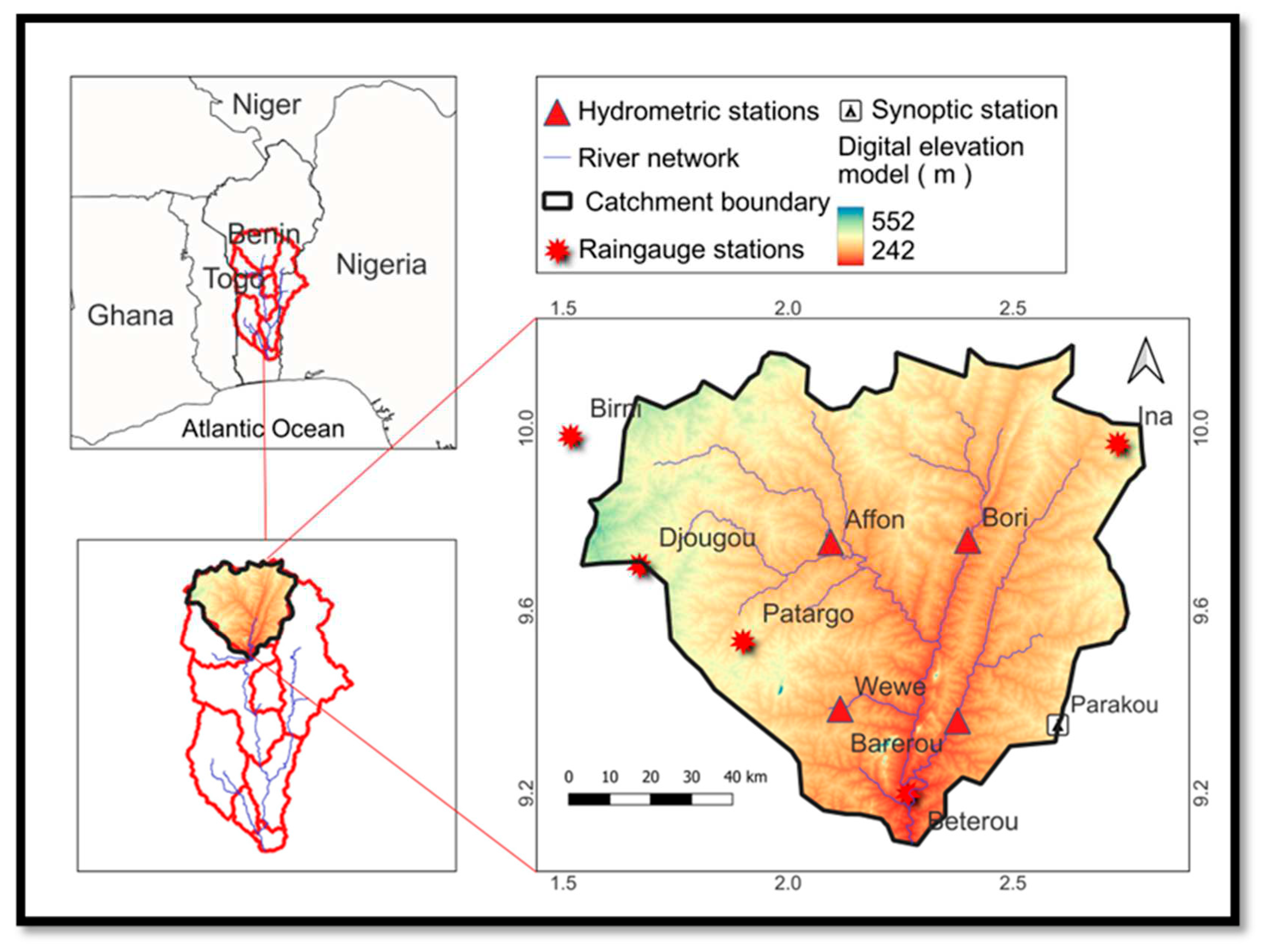
Figure 2.
Monthly average rainfall and temperature between 1986 and 2021. (Data collected from Benin Meteorological Services)
Figure 2.
Monthly average rainfall and temperature between 1986 and 2021. (Data collected from Benin Meteorological Services)
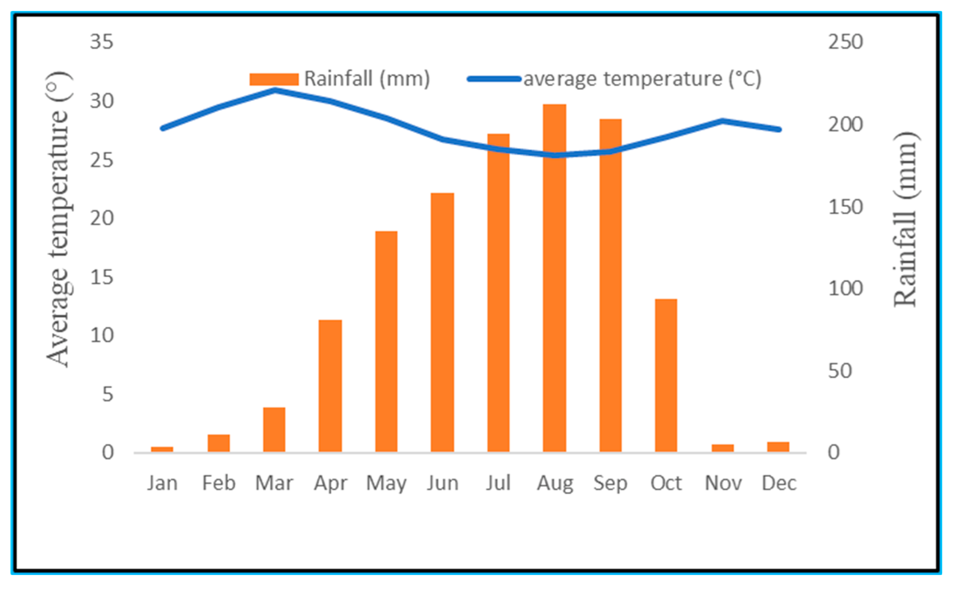
Figure 3.
Spatial input data used for the model.
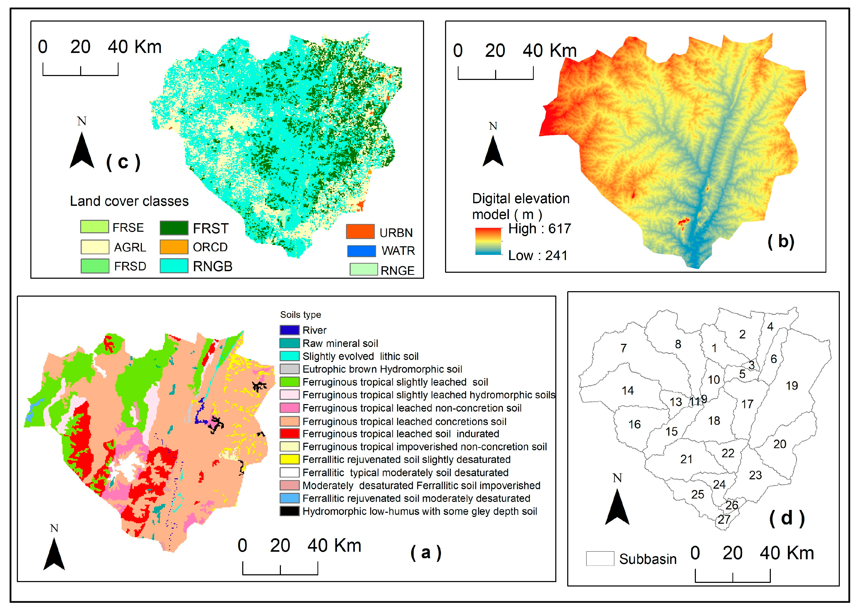
Figure 4.
Soil distribution in the study area.

Figure 5.
Methodology framework adopted for this study.
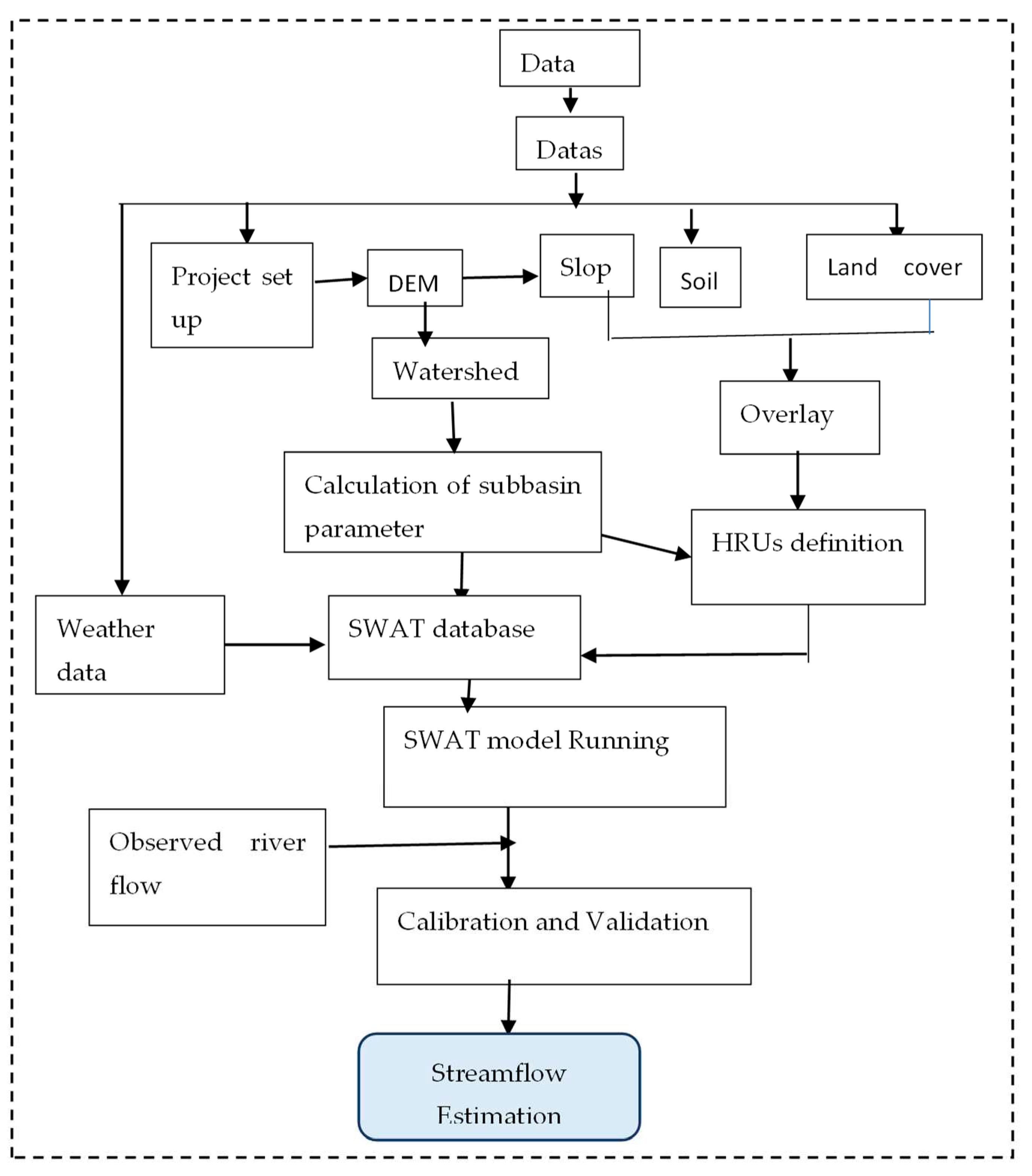
Figure 6.
P-value results of sensitivity analysis of SWAT-CUP, for validation procedure using site-based streamflow data
Figure 6.
P-value results of sensitivity analysis of SWAT-CUP, for validation procedure using site-based streamflow data

Figure 7.
P-value results of sensitivity analysis of SWAT-CUP, for validation procedure using site-based streamflow data.
Figure 7.
P-value results of sensitivity analysis of SWAT-CUP, for validation procedure using site-based streamflow data.
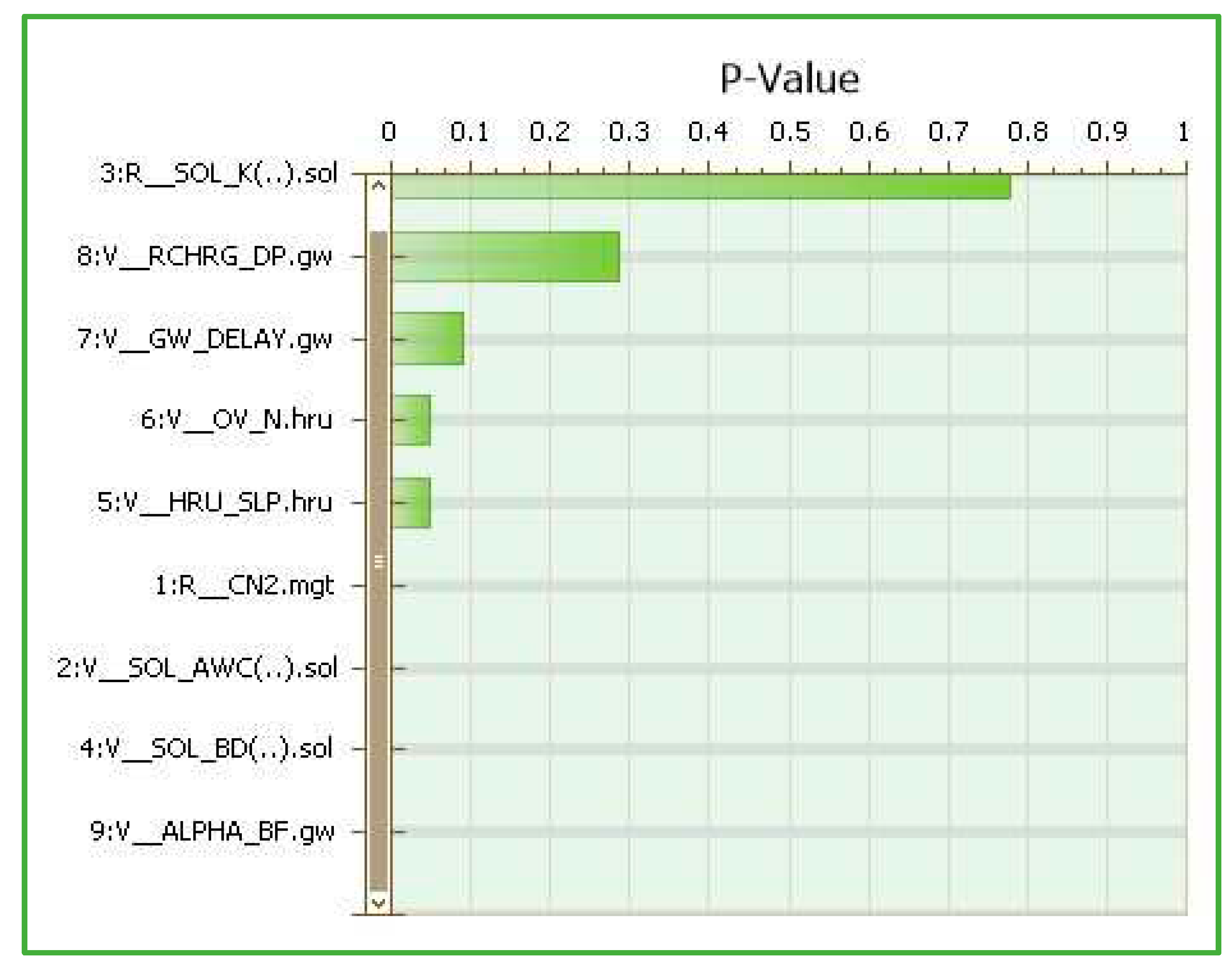
Figure 8.
Best simulation against the observed time series of flow parameters and the plot of the 95PPU diagram for calibration.
Figure 8.
Best simulation against the observed time series of flow parameters and the plot of the 95PPU diagram for calibration.
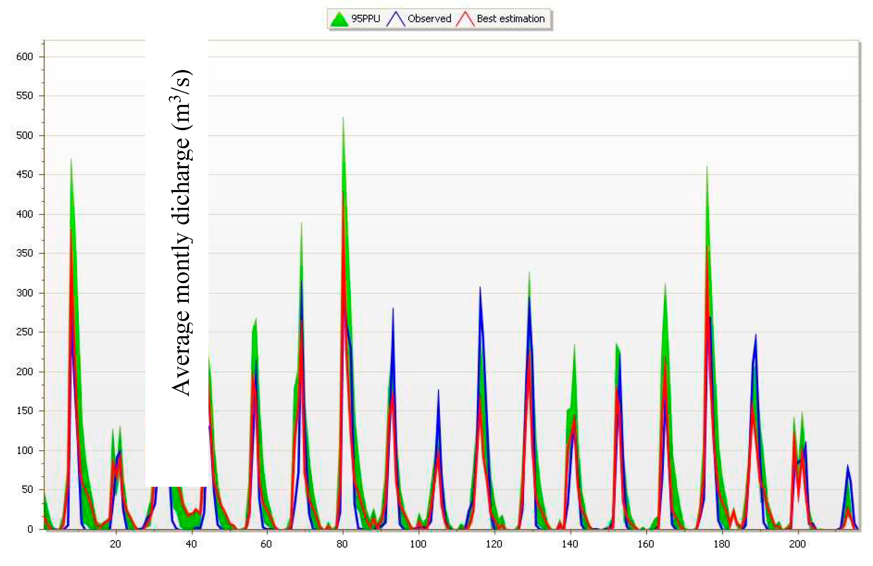
Figure 9.
Best simulation against the observed time series of flow parameters and the plot of the 95PPU diagram for validation.
Figure 9.
Best simulation against the observed time series of flow parameters and the plot of the 95PPU diagram for validation.
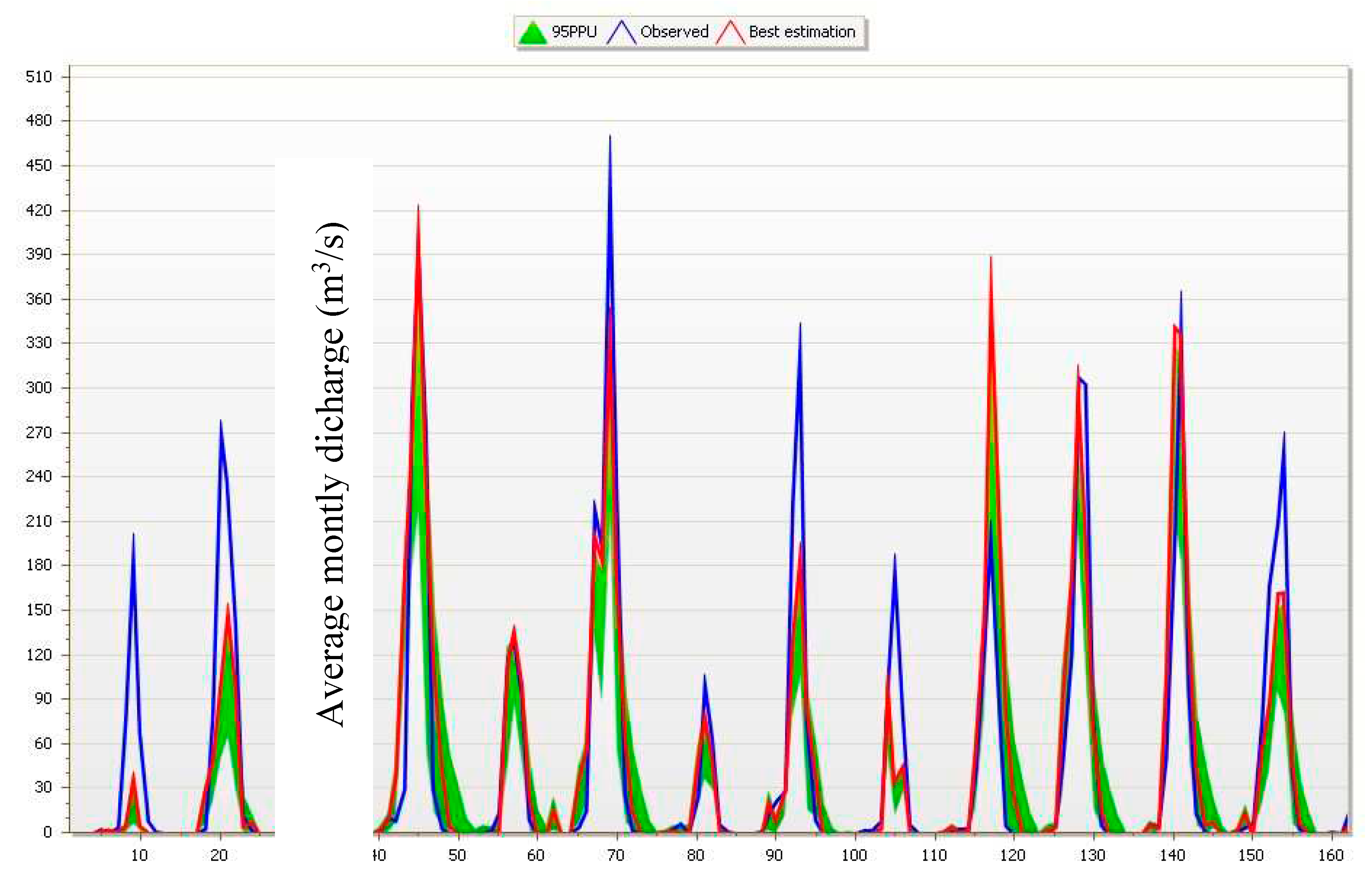
Figure 10.
Scatter plot of monthly river discharges for calibration (1898-2006).
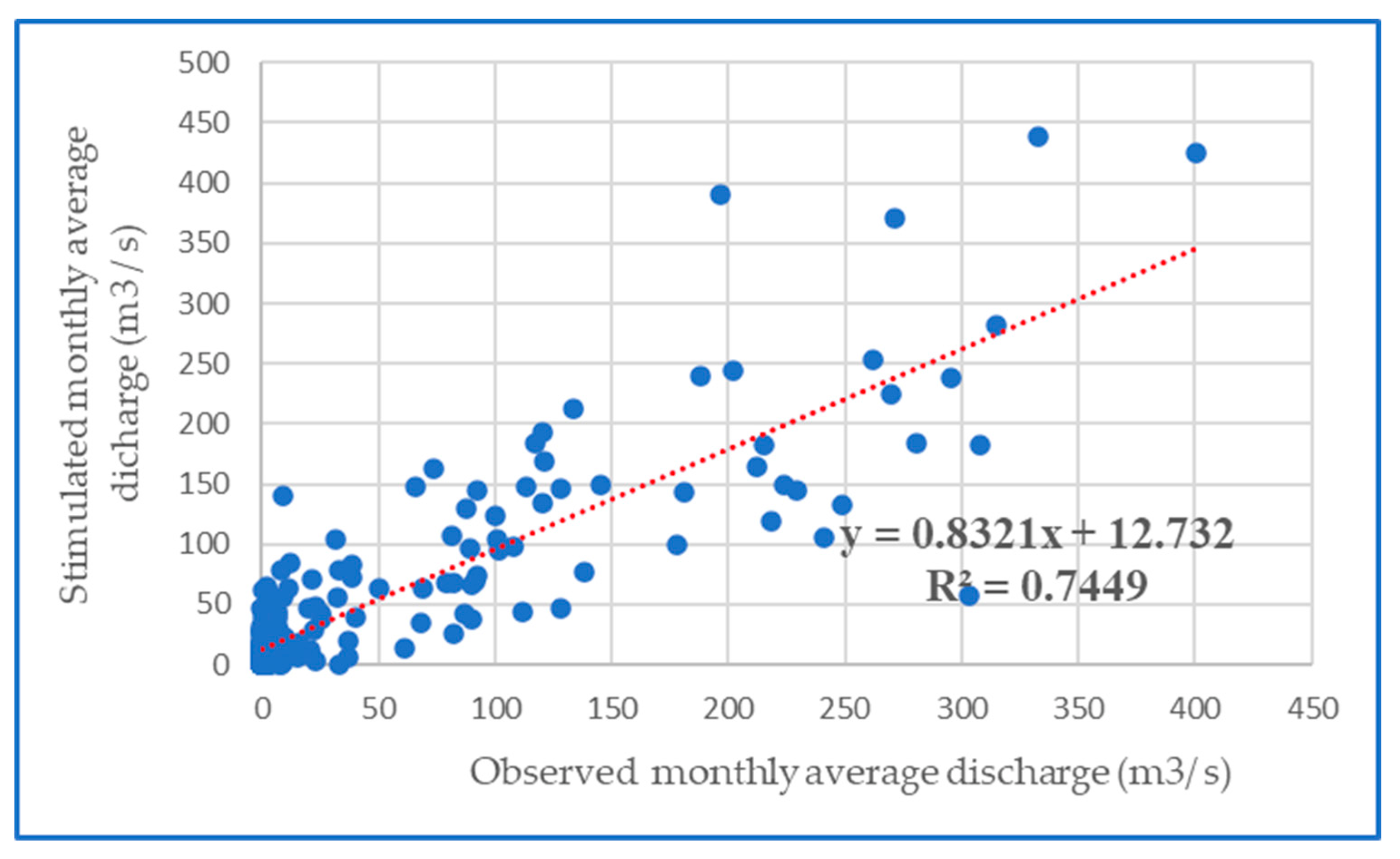
Figure 11.
Scatter plot of monthly river discharges for validation (2007-2020).
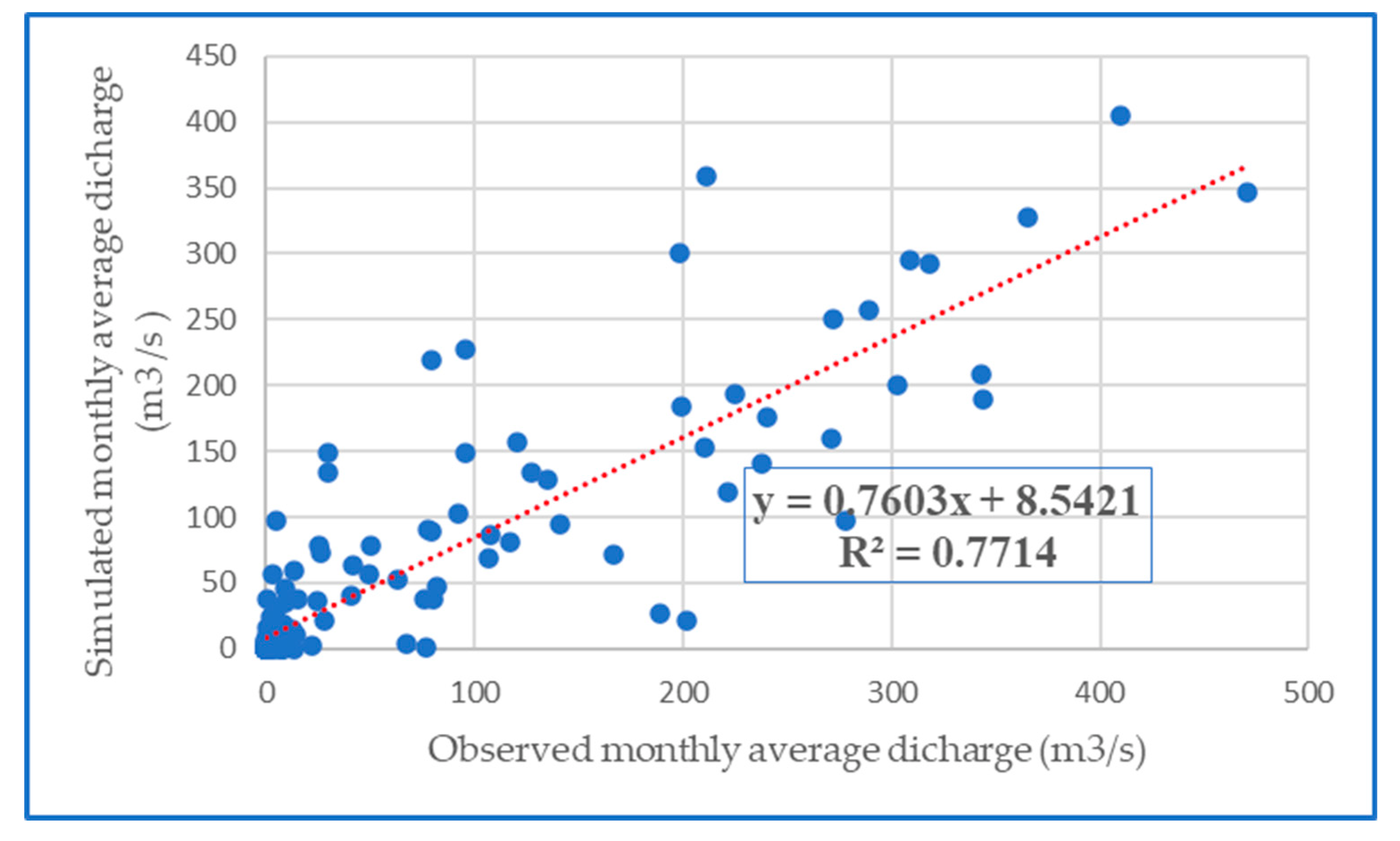
Figure 12.
Water balance components estimation for calibration from 1989-2006.
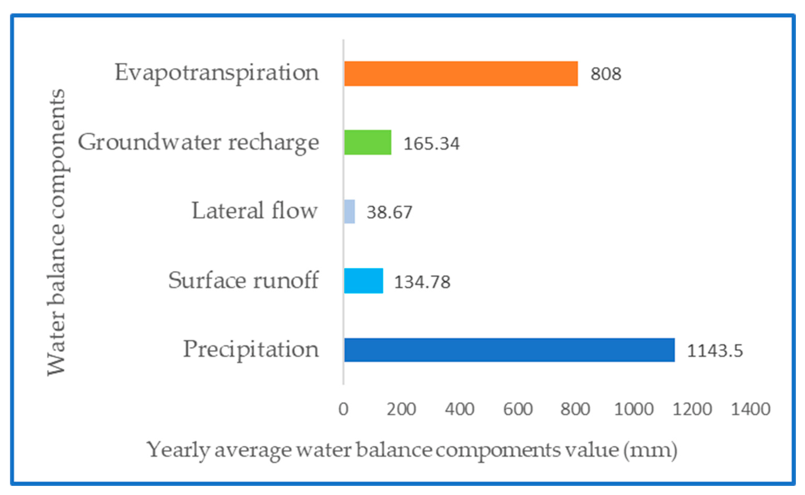
Figure 13.
Water balance components estimation for validation from 2007-2020.
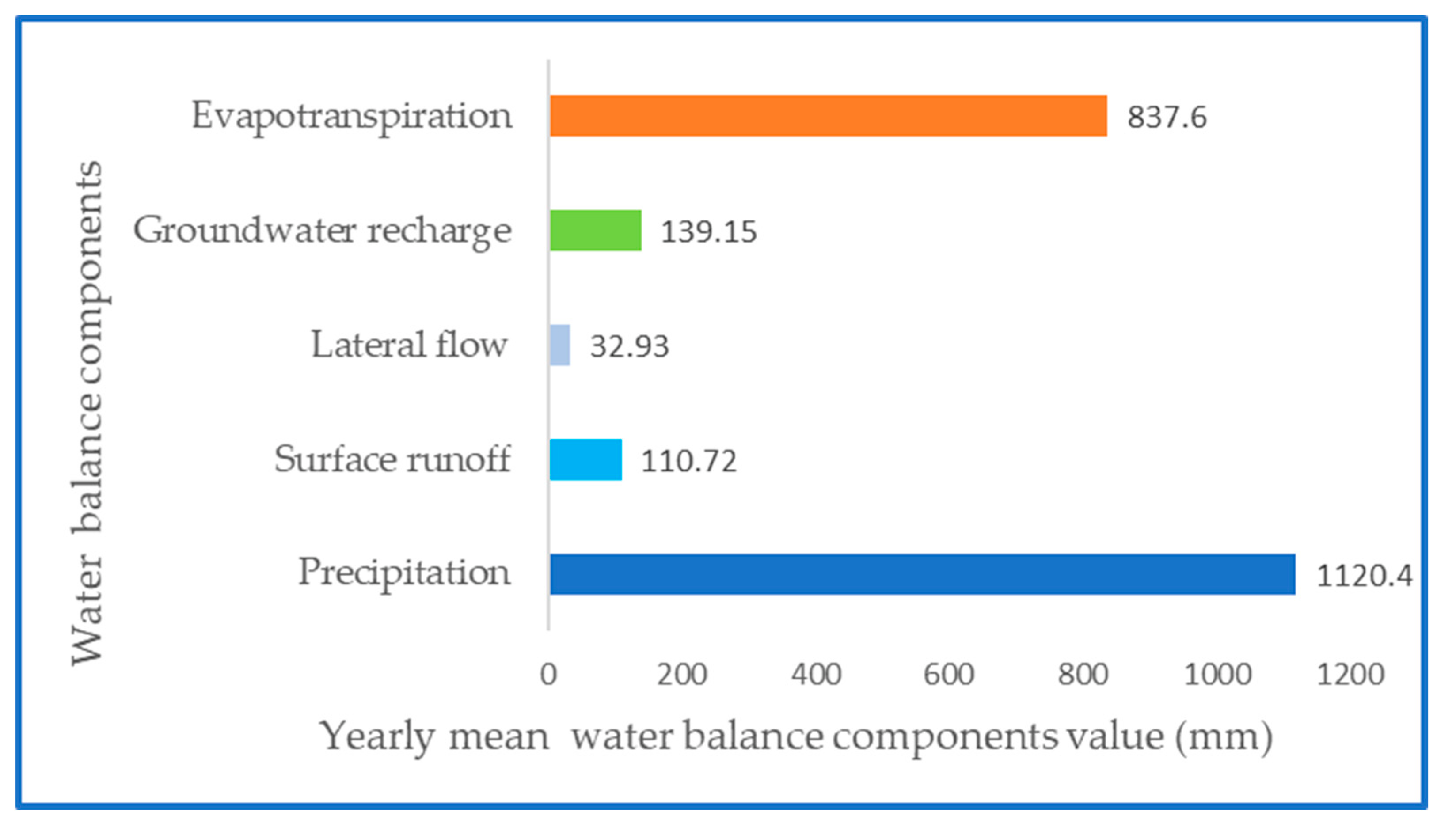

Table 1.
The land use distribution in the study area.
| SWAT code | Description | Area (km2) | % watershed |
| AGRL | Agriculture | 2478.70 | 24.6 |
| URBN | Settlement | 34.26 | 0.34 |
| WATR | Water | 1 | 0.01 |
| FRST | Forest-mixed | 1596.04 | 15.84 |
| ORCD | Orchard | 19.14 | 0.19 |
| FRSE | Forest-evergreen | 250.89 | 2.49 |
| FRSD | Forest-deciduous. | 46.35 | 0.46 |
Table 2.
Sensitive SWAT parameters ranges, and results of P-value and t-Stat sensitivity analysis of SWAT-CUP (V means replace and R means relative change).
Table 2.
Sensitive SWAT parameters ranges, and results of P-value and t-Stat sensitivity analysis of SWAT-CUP (V means replace and R means relative change).
| Parameters names | T-stat | P-value | Parameters ranges used in this study |
| R__CN2.mgt | 127.459 | 0.00 | (-0.06, -0.05) |
| V__ALPHA_BF.gw | -15.22 | 0.00 | (0.007, 0.01) |
| V__GW_DELAY.gw | 375.13 | 0.00 | (13.37, 18.41) |
| V__REVAPMN.gw | 0.012 | 0.98 | (498.94, 499.24) |
| V__OV_N..hru | 79.3 | 0.00 | (0.13, 0.15) |
| V__SOL_BD..sol | -30.19 | 0.00 | (0.62, 1.28) |
| V_RCHRG_DP.gw | 171.12 | 0.00 | (0.06, 0.08) |
| V__SOL_AWC.sol | 2.74 | 0.00 | (0.39, 0.44) |
| V_SLSUBBSN.hru | 1.48 | 0.13 | (72.61, 77.98) |
| V__USLE_P.mgt | -32.05 | 0.00 | (0.13, 0.39) |
| R_SOL_K (1).sol | 107.14 | 0.00 | (-0.06, 0.46) |
| V_HRU_SLP.hru | 24.33 | 0.00 | (0.73, 0.78) |
Table 3.
Model performance statistics for the Beterou catchment.
| Time step | Calibration | Validation | |
| Criterion | |||
| Montly | R2 | 0.80 | 0.78 |
| NSE | 0.79 | 0.78 | |
| PBIAS (%) | -12.2 | 3.1 | |
| RSR | 0.45 | 0.47 | |
| KGE | 0.83 | 0.85 | |
Disclaimer/Publisher’s Note: The statements, opinions and data contained in all publications are solely those of the individual author(s) and contributor(s) and not of MDPI and/or the editor(s). MDPI and/or the editor(s) disclaim responsibility for any injury to people or property resulting from any ideas, methods, instructions or products referred to in the content. |
© 2023 by the authors. Licensee MDPI, Basel, Switzerland. This article is an open access article distributed under the terms and conditions of the Creative Commons Attribution (CC BY) license (http://creativecommons.org/licenses/by/4.0/).
Copyright: This open access article is published under a Creative Commons CC BY 4.0 license, which permit the free download, distribution, and reuse, provided that the author and preprint are cited in any reuse.


