
Submitted:
10 October 2023
Posted:
12 October 2023
You are already at the latest version
Abstract
Amid urgent global climate and biodiversity crises, the strategic restoration of degraded forests stands as a vital countermeasure. This study pioneers a novel approach for the identification and prioritization of potential degraded forest areas suitable for restoration (PDFR), utilizing the advancements in Earth observation data. Utilizing Landsat data within the Google Earth Engine, our PDFR method applies a nuanced, phenology-based threshold classification to accurately map forest covers at a 30-m resolution, distinguishing prime restoration areas such as evergreen, semi-evergreen, deciduous, and flooded forests, and categorizing them into varying levels of degradation using Siem Reap, a province in Cambodia as a case study. The projections indicate a promising potential for carbon sequestration through restoration of the critically (~96,693 ha), highly (48,878 ha), moderately (46,487 ha), and slightly degraded (75,567 ha) forests, estimating a capture of 193.73 TgCO2 in Siem Reap from 2021 to 2030 upon comprehensive restoration initiatives. As Earth observation technologies continue to evolve, the PDFR method emerges as a strategic blueprint for data-driven policy formulation, fostering sustainable forest management and aligning with the global commitments delineated in the Glasgow Forests Declaration for 2030.
Keywords:
carbon sequestration
; forest restoration
; Google Earth Engine
; innovation
; REDD+
1. Introduction
The recent surge in forest restoration urgency has emerged as a pivotal response to the ongoing global climate crisis and the continuous threat to biodiversity [1,2] (Griscom et al., 2020; Malhi et al., 2020). Through appropriately devised forest management and restoration activities, it is feasible to mitigate climate change and slow down the current pace of biodiversity loss, which is essential to prevent a decline in ecosystem services that society heavily depends upon [2,3,4] (Karger et al., 2021; Malhi et al., 2020; Turney et al., 2020). The most recent stride in global conservation efforts is manifested in the Glasgow Forests Declaration, established at the 26th UN Climate Change Conference of the Parties (COP26) of the UNFCCC in 2021 to further mobilize governments and private entities in the pursuit of forest and ecosystem restoration on a grand scale [5] (UNFCCC, 2021). This declaration serves as a testament to the international community's dedication to fostering collaborations and harnessing innovative solutions to address the pressing challenges of forest degradation, climate change, and biodiversity loss [6] (Gasser et al., 2022).
Forest restoration has been accentuated by the Millennium Ecosystem Assessment as a prime policy intervention to recover the deteriorated ecosystem services in forests [7] . Moreover, the promotion of the Reducing Emissions from Deforestation and forest Degradation (REDD+) initiative as a strategy for augmenting carbon stocks has been highly recommended [8,9]. In 2011, the initiation of the Bonn Challenge, later supported and expanded through the New York Declaration on Forests (NDYF), garnered the endorsement of over 200 governments and organizations. The NYDF laid down significant milestones: putting an end to the loss of natural forests and restoring 350 million hectares of degraded forests by the year 2030 [10]. Furthermore, in 2019, the United Nations General Assembly proclaimed 2021-2030 as the UN Decade on Ecosystem Restoration, recognizing the pivotal role ecosystem restoration holds in tackling the global climate crisis and the loss of ecosystem services. This initiative encourages the rehabilitation of degraded ecosystems [11] and the preservation of those still intact [10].
Implementing forest and ecosystem restoration necessitates various interventions and strategies, such as ongoing monitoring to facilitate successful large-scale restoration activities [12,13]. A fundamental strategy for effective forest restoration is the pinpointing of degraded lands that are amenable to restoration, thus aligning with the goals of the NYDF to halt further forest degradation and protect existing native forests [2,3,14,15].
In light of the increasing involvement of governments and private sectors in forest and ecosystem restoration, several guidelines and frameworks have been formulated to foster successful restoration. For instance, the Society for Ecological Restoration has promulgated specific guidelines [16], and The Nature Conservancy has devised a practical framework for spatial restoration planning [17]. Collaboratively, the International Union for Conservation of Nature and the World Wide Fund for Nature introduced a site-based approach in 2003 for the rehabilitation of degraded forests [18], followed by FAO's guidelines for restoring degraded landscapes in drylands in 2015, utilizing spatial applications by IUCN [19,20]. Moreover, the IUCN recently formulated a Global Standard for Nature-based Solutions, providing criteria and guidance for implementing effective NbS projects [21].
Certain studies have argued that passive restoration of intact forest lands could be a cost-efficient approach [22,23], given that intact forests require lesser restoration compared to their degraded counterparts. Sasaki et al. [12] proposed a methodical classification of degraded forests before implementing restoration strategies. They suggested categorizing forests based on degradation severity and adopting a phased approach to passive restoration techniques could potentially minimize restoration costs. Nevertheless, passive restoration also presents challenges, including determining suitable locations and cost-effective methodologies, and establishing supportive policies to escalate restoration efforts [10,20]. Additionally, evaluating the potential carbon sequestration in restored forests, especially in areas covered by the REDD+ scheme, remains a priority.
An earlier study by Löf et al. [23] unveiled that utilizing spatio-temporal information on forest degradation and cover types can facilitate forest categorization and shape necessary changes to attain restoration goals. The Google Earth Engine (GEE) platform offers an efficient solution for acquiring and analyzing extensive remotely sensed data vital for these assessments. The platform enables swift and affordable processing of data spanning over three decades for research and educational purposes [24]. Despite the GEE platform's recent utilization in tracking global forest cover changes and land use mapping [25], limited research has explored its potential in determining forest degradation levels, a necessity underscored by global agreements such as the NYDF and the UN Decade on Ecosystem Restoration.
This study aims to categorize degraded forests according to their levels of degradation to facilitate effective forest restoration using the GEE and geographical information science tools. We also envisage assessing potential carbon sequestration in restored forests, aligning with the carbon-based incentives of the REDD+ initiative. The province of Siem Reap in Cambodia serves as the focal point of this case study. Leveraging the increasing availability of remotely sensed data and cloud computing technologies, the potential degraded forests for restoration method (PDFR) aspires to significantly contribute to achieving the targets set by the NYDF, the UN Decade on Ecosystem Restoration, and and the Glasgow Forests Declaration by 2030.
2. Materials and Methods
2.1. Study area
In 2019, Siem Reap province (study area) in Cambodia had a total population of approximately 1 million, with an annual growth rate of 1.1% [26]. It has a total land area of 10,299 km², making it the tenth largest province and ranked fourth in Cambodia in terms of area and population, respectively. Siem Reap is major destination for domestic and international tourists, welcoming roughly 2.2 million persons annually from 2015 until the outbreak of COVID-19 [27]. Siem Reap province hosts the UNESCO World Heritage Angkor archaeological sites [28]. As shown in Figure 1, the landscape of Siem reap is a mosaic of both flooded and upland forests, and rice fields. The province has five designated protected areas: Kulen Promtept Wildlife Sanctuary, Phnom Kulen National Park, Angkor Protected Landscape, Tonle Sap Multiple-use Area, and Beng Per Wildlife Sanctuary (Figure 1) [29,30].
Note: Data of economic land concession, protected areas, and village locations were collected from the open development Cambodia (www.opendevelopmentcambodia.net/). Water bodies, river, and stream data were collected from the DIVA-GIS (www.diva-gis.org/). Road data was collected from the open street map (www.openstreetmap.org). The land cover map of 2018 was obtained from Venkatappa et al. [31].
The protected areas are important for maintaining the intact ecosystems and biodiversity in the region [29]. The great lake Tonle Sap which lies in the southern part of the study area (Figure 1) is a reservoir for the larger Mekong River during the rainy season (May–November). Most people in the province depend on rainfed agriculture and forest products for their livelihoods. Alternatively, tourism is an important income source for people living near the Angkor archaeological sites and Tonle Sap Lake [32].
Six categories of forests were classified in Siem Reap: evergreen, semi-evergreen, deciduous, flooded, bamboo, and mixed wood and shrubland. Among the land cover categories, non-forested land comprised the largest portion (65%) of the region in 2005 [33]. Attributed to anthropogenic activities such as the clearing of forests inside the economic land concessions in the province, 322,694 ha of forest cover was lost between 1990 and 2018, representing an annual deforestation rate of 1.3% [34].
2.2. Forest cover data
Google Earth Engine (GEE) has acquired and stored satellite remote sensing data covering most of the earth for over 30 years. It uses machine learning algorithms to assess and classify remote sensing and spatial data. Various image processing approaches are also available for processing these remote sensing data on the GEE for different needs [24]. Specifically, computed images at-sensor radiance, top-of-atmosphere (TOA) reflectance [35], cloud score, cloud-free composites, and land use land cover classification algorithms are made accessible to the public from the GEE and are ready-to-use for educational and research purposes at any scale [36]. We used forest land cover change data derived from Landsat 5 Thematic Mapper (TM) satellite between 1990 and 2010, and Landsat 8 Operational Land Imager (OLI) TOA ortho-rectified collections from 2014 to 2018 covering the whole Siem Reap province using the JavaScript in GEE cloud. This included 159 satellite image collections in GEE. We applied a newly developed phenology-based threshold classification method using GEE to assess the forest land cover change in the study area [37]. A detailed assessment of the PBTC method in GEE was described in our previous study [34].
2.3. Methodological framework for determining potential degraded forests for restoration (PDFR)
The Potential Degraded Forests for Restoration (PDFR) method is applicable for defining areas of degraded forest suitable for restoration using appropriate restoration strategies. We developed the PDFR methodological framework to assess forest degradation and degraded forest land available for forest restoration along with their potential carbon stocks and sequestration by 2030 (Figure 2). Landsat forest cover data at 30-m resolution between 1990 and 2018 were used to assess the forest cover change in the study region. Forest cover data in 2010 and 2018 were applied for determining the levels of forest degradation, as a high rate of forest degradation began in the region in 2010 [34]. Further, we applied the IDRISI Selva land change modeler tool from CLARKLABS (www.clarklabs.org) to identify the forest transition from 2010 to 2018. This tool was used to assess the percentage of forest degradation (Figure 2).
2.4. Levels of degraded forests
As high forest degradation has occurred in Siem Reap since 2010 [38,39], we selected the forest cover data in 2010 as the base year and assessed the levels of forest degradation between 2010 and 2018. We then calculated the percentage of forest cover lost by using a land change modeler [40,41,42] and classified the degradation levels by forest categories for restoration (Figure 3).
By employing these strategies for forest restoration [12], the percentage of forest degradation between 2010 and 2018 was estimated. Accordingly, forest degradation and forest cover changes by five forest categories were grouped by the degraded forests in each forest category. After the percentage of change was obtained, we classified four levels of forest degradation for each category: slightly degraded forest (a loss of 10% or less); moderately degraded forest (10–30% of the forest was degraded); highly degraded forest (30–70% degraded); and critically degraded forest (70–90% deforested). If more than 90% of the area was degraded the area was not classified as a forest land cover.
Figure 3.
Levels of forest degradation in Siem Reap as a percentage of forest cover change per hectare (Source: Authors).
Figure 3.
Levels of forest degradation in Siem Reap as a percentage of forest cover change per hectare (Source: Authors).
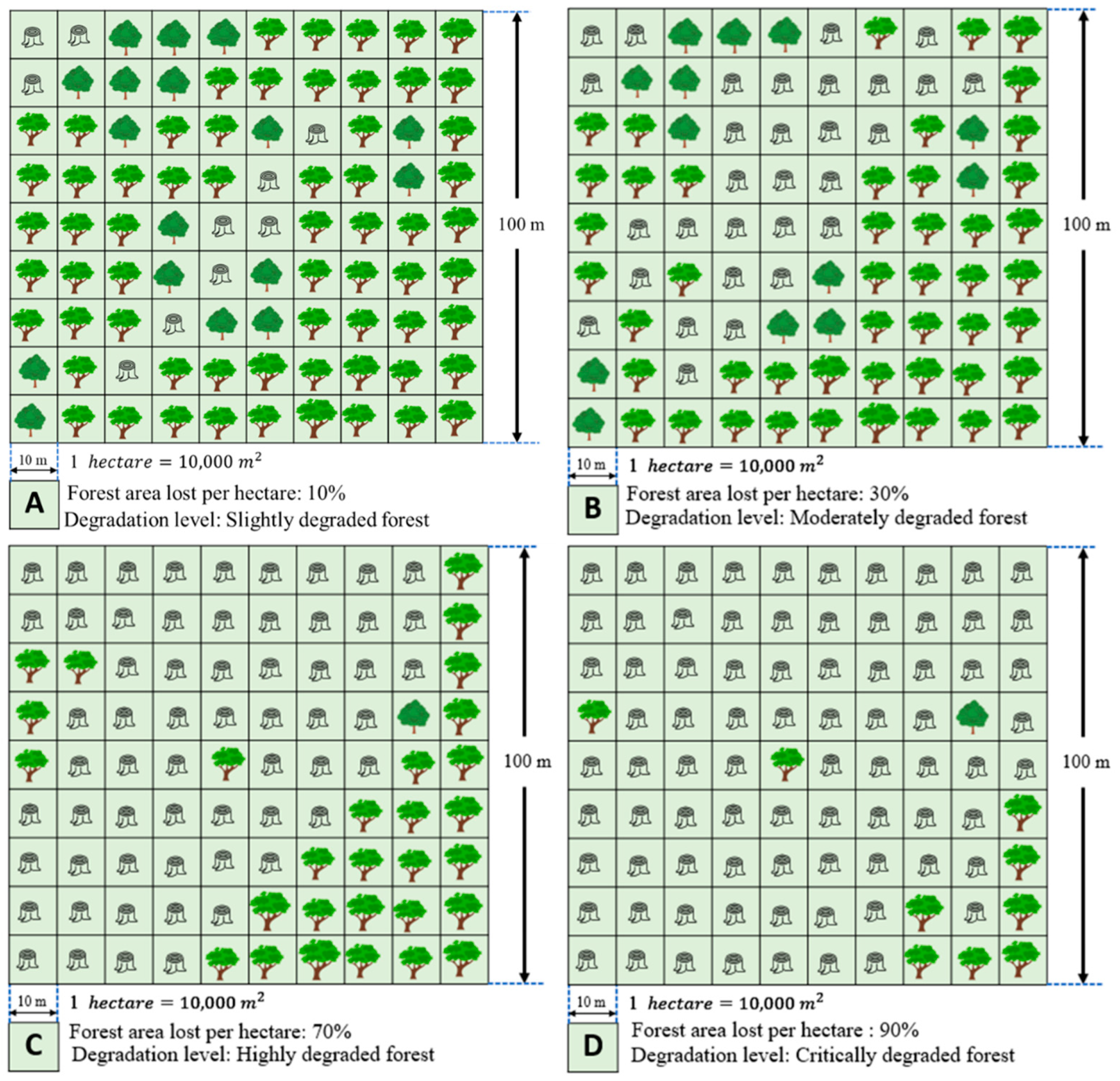
Note: Forest categories include evergreen, semi-evergreen, deciduous forest, mixed wood and shrublands, and flooded forest [38]. The figure panels show the degradation levels as a percentage per hectare (ha) adapted from the PDFR framework. Figure 3A refers to slightly degraded forest, Figure 3B represents moderately degraded forest, Figure 3C shows highly degraded forest, and Figure 3D is critically degraded forest. We did not consider the bamboo forest category in the PDFR model because the portion of forest cover did not change compared to other forests, bamboo forest areas were relatively small compared to other categories, and natural bamboo forests were in undisturbed mountain regions in the study region during the PDFR modeling period [34].
2.5. Criteria for selecting areas for restoration
Population, accessibility, and costs should be considered when determining potential areas for forest restoration. Previous studies have revealed that population growth, new road development, and agricultural expansion are the major drivers of forest loss in recent decades [43,44,45,46]. In this study, two criteria were considered to ensure a high potential for success when selecting locations of degraded forests for restoration: distribution of urban areas (linked to population growth) and road networks (accessibility).
2.5.1. Population distribution
As forest restoration would not be practicable in populated areas or on roadways, such areas should be excluded from the selection of degraded forests for restoration. The village location and population data in 1988, 2008, and 2015 [47] were obtained from the ministry of planning, Cambodia [48]. Distribution of the population density per square kilometer (km2) was extracted from village-level historical population data and future population density predicted until 2050 [49] using Equations (1) and (2). Village level historical population data [49] were used for assessing the population growth and predicting the future population density by 2050 at the village scale using the formula below (Haddock et al., 2008). We then generated the gridded population density data (persons km-2) using the Kriging interpolation methods available in the Esri ArcMap spatial analysis density tool.
Population growth rate:
where,
PR = Population growth rate (PR is assumed to be constant during the modeling timeframe between 2015 and 2050).
P(2015) = Population living in Siem Reap province in 2015.
P(1988) = Population living in Siem Reap province in 1988.
n = Total years (17 years) between the two-time intervals.
Equation (2) was used for calculating the predicted population on the individual grids given the current population and growth rate:
where,
PP(2050) = Gridded population in 2050,
P(2015) = Population living in Siem Reap province in 2015, and
m =Total years (35 years) from the base population in 2015 and the ending period of the population growth prediction in 2050.
The obtained raster data of the predicted population density in Equation (2) were used as criteria for excluding degraded forests in the populated areas.
2.5.2. Datasets of road networks
To spatially allocate the predicted population described in the previous section, we assumed that the growing population would settle along existing roads. Four road categories were considered: main roads (national roads that are operational year-round), secondary roads (provincial roads supplementary to the main roads), tertiary roads (district or community roads linking smaller settlements and villages), and feeder trails (village roads that may or may not exist depending on whether the locals use them). Feeder roads can also be roads linking villages to forest areas. Road datasets of main roads, secondary roads, and tertiary roads were collected from open street map (www.openstreetmap.org). The dataset of feeder trails was manually generated using Esri high-resolution world imagery in ArcMap (Figure 1).
2.6. Degraded forests for potential restoration
To determine areas of degraded forest with potential for restoration, we created a 400-m road buffer using the ArcMap buffer tool (Figure 2) to exclude potential restoration areas within 400 m of both sides of existing roads. These areas are likely to be occupied by a growing population [50]. We combined road buffer, population density, and degraded forest data to generate the PDFR dataset by assigning a systematic weighting system in the ArcMap environment according to the IUCN ROAM criteria [20]. When doing so, we considered the levels of degraded forest (Sasaki et al., 2011) in the respective forest categories shown in Table 1. The weighted scores of individual degraded forests by degradation levels were used to convert the forest, road, and gridded population data to a raster dataset using ArcMap raster conversion tool. We then reclassified them accordingly. A weighted score of 1.5 [20] was applied for each of the levels of forest degradation. However, assessment scores were assigned according to the forest degradation level (i.e., critically degraded forest = 4, highly degraded forest = 3, moderately degraded forest = 2, and slightly degraded forest = 1).
CDF, HDF, MDF, and SDF =1 adopted from Sasaki et al. [12]. Forests with no detected disturbance were assigned an assessment score of 0 because restoration was not applicable. The following constraints were also applied: the forest restoration area should not be within a 400-m buffer distance from all road types, should not be within the predicted 2050 population density radius, and should not be within a rubber plantation. After the PDFR was determined, we assigned one of four forest restoration strategies to each of the degradation levels (as proposed by Sasaki et al. [12]. These strategies were: assisted natural regeneration (ANR), enrichment planting (EP), preventing logging reentry (PLR), and reduced impact logging (RIL) (Table 1).
2.7. Carbon stocks and carbon revenues in restored forests
2.7.1. Carbon stocks per hectare in restored forests
Assessing the forest degradation levels, identifying lands with potential for forest restoration, and predicting carbon sequestration or removal from the forest restoration categories provide spatial estimates of where, and to what extent, forest restoration is likely to mitigate climate change [50]. Equations (3) to (5) were used to assess carbon stocks and sequestration in degraded forest lands [51].
where,
CSi (t): Carbon stocks of the degraded forests i at time t (MgC ha-1),
CSi (0): Initial carbon stocks of the degraded forests i in 2021 (MgC ha-1),
CMAX,i = Maximum carbon stock potential a restored forest can attain; and
ri = degraded forest growth rate i (%).
The initial values of carbon stocks in the respective degraded forests (CSi (t0)) were taken from Sasaki et al. [12] as follows: slightly degraded forest, 148 MgC ha-1; moderately degraded forest, 60 MgC ha-1; highly degraded forest, 32 MgC ha-1; and critically degraded forest, 27 MgC ha-1. Once restored, forests are expected to grow logistically, reaching a maximum point equivalent to the carbon stock value of intact forests, which is assumed to be 500 MgC ha-1 [52]. With this assumption, the growth rate ri of the respective degraded forests can be calculated: slightly degraded forest, 0.008; moderately degraded forest, 0.013; highly degraded forest, 0.260; and critically degraded forest, 0.046.
2.7.2. Total carbon stocks in all restored forests
Total carbon stocks in the restored forests over time can be derived by:
where,
TCSi(t): Total carbon stocks in degraded forests i at time t (MgC year-1) and
PDFRi: Area of the PDFR i (ha).
Carbon sequestration or removal due to forest restoration can be obtained by:
where,
CSSi(t): Carbon sequestration (removal) in the degraded forest i at time t (MgCO2e year-1),
44/12 is the molecular weight of CO2 over carbon, and
t2 and t1 are the different time intervals for calculating carbon sequestration (year).
2.7.3. Carbon-based revenues
As a forest area is restored, the annual increment of carbon sequestration or carbon removal can be eligible for financial compensation under the result-based payment of the REDD+ scheme of the UNFCCC. Carbon revenues (financial compensation) can be obtained by:
where,
CRi(t): Annual carbon revenues due to carbon removal in the restored forest (degraded forest) i (US$) and
CP: Carbon price (US$ per Mg of CO2).
For comparison, the following new carbon pricing instruments were used to estimate the carbon revenues: US$4.32 was the price under China’s Emission Trading Scheme (ETS), US$10.00 under the Voluntary market, US$24.80 according to the UK carbon price support, US$35.24 based on the Netherlands carbon tax, US$49.78 under the EU ETS, and US$137.24 based on the Sweden carbon tax [53]. The recent report by the World Bank [54] indicates that the carbon price corridors for achieving the Paris Agreement are between US$60-120. The carbon sequestration and removal period used for calculating carbon revenues is between 2021 and 2030, the implementation period for the next Paris climate agreement in 2030.
3. Results
3.1. Forest cover change
Natural forest categories observed in the Siem Reap Province were evergreen forest, semi-evergreen (SEG) forest, deciduous forest, mixed wood and shrubland, flooded forest, and bamboo (Figure 4). Among the seven main forest categories, the evergreen forest coverage declined from 19.5% to 10%, SEG forest coverage declined from 16.2% to 9.8%, deciduous forest coverage was reduced from 23.2% to 19.7%, mixed wood and shrubland areas declined from 16.1% to 7.2%, and the flooded forests sharply declined from 13.5% to 8% over 28 years (1988–2018). Approximately 89% of the province was covered by forest in early 1990. The forested area decreased to 78% from 1998 to 2000, and sharply declined (to 55%) after economic land concessions (ELC) were granted from 2012 to 2018. The annual rate of forest change is approximately -0.013% between 1990 to 2018 and increased to -0.016% between 2010 and 2018. Between 1990 and 2018, the province lost 322,694 ha of forested area. Furthermore, the forested area sharply declined from 777,091 ha in 2010 to 546,760 ha in 2018 (Table 2).
An increase in population, new households, and ELC development in Siem Reap province (Figure 1) also led to deforestation and forest degradation in the region [55]. The major causes of forest degradation in the study region were an expansion of cropland (from 10.2% to 36.7%) and the addition of rubber plantations (approximately 1%) under the ELC from 1988 to 2018 (Figure 4).
3.2. Areal extent of degraded forests
Forest degradation can occur through the removal of trees or woody biomass (e.g., selective logging or infrastructure construction) or through the collection of non-timber forest products (e.g., fruits, nuts, or bushmeat) [26]. By applying the PDFR framework, we identified 466,737.9 ha of forests in Siem Reap province at critically, highly, moderately, and slightly degraded levels. This area was comprised of 207,218.0 ha critically degraded, 75,894.0 ha highly degraded, 65,091.0 ha moderately degraded, and 118,536.0 ha slightly degraded forests. These degraded forests were considered for their potential suitability for restoration (Figure 5). By applying our PDFR framework in degraded forest lands, we estimated potential lands for forest restoration in the Siem Reap province to be 96,693.0 ha in critically degraded forest, 48,878.0 ha in highly degraded forest, 46,487.0 ha in moderately degraded forest, and 75,567.0 ha in slightly degraded forest (Figure 5d).
Approximately 16% or 69,915.0 ha of evergreen forests were degraded over the past 8 years (2010–2018). Specifically, 7% (approximately 31,447.0 ha) of evergreen forests were highly degraded, 6% slightly degraded, and 3% critically degraded in the province (Figure SI-1). About 24% of the semi-evergreen forest was degraded, but only 12% was at the moderately degraded stage. We found that approximately 4% (110,485.0 ha) of the degradation in the province was caused by agricultural land encroachment. Highly degraded evergreen and semi-evergreen forests were observed in Varin and Chi Kraeng districts in the northern and northeastern part of the province where the ELC was introduced. Most of the evergreen and semi-evergreen forest land was converted to rubber plantations. Moreover, we found that 14%, 10%, and 31% of the deciduous forests (142,766.4 ha) were critically, moderately, and slightly degraded, respectively. Other categories of land cover such as the mixed wood and shrublands also experienced critical degradation, accounting for about 21% of the area in the province. These two categories were chiefly converted to cropland (25%, or approximately 118,942.0 ha of these categories was lost). About 24,63.0 ha of flooded forests remain in the critical degradation (3%) stage. Across all forest categories, Siem Reap province forest lands remain degraded, with 44% (207,218.0 ha) critically degraded, 16% highly degraded, 44% moderately degraded, and 25% slightly degraded (Figure SI-1).
3.3. Strategies for restoring degraded forests
The NYDF calls for the protection and restoration of degraded forests as a method for mitigating hazardous environmental shifts and contributing to fulfilment of the United Nations’ Sustainable Development Goals (SDGs) [13]. However, questions remain related to the strategies and priorities of global restoration efforts [11,56]. Our novel method for cheaply and quickly identifying candidate-degraded areas for restoration provides a new capability for addressing this key enabling step towards the fulfilment of the NYDF goals.
As a demonstration of the new PDFR method, we identified and prioritized potential degraded forests for restoration in Cambodia’s Siem Reap Province. Our analysis suggests focused locations and methods of restoration. Additionally, the PDFR method provides for estimating the amount of potential carbon that can be sequestrated from the restored lands by 2030. In this study, we proposed four plausible restoration strategies based on forest degradation levels: assisted natural regeneration (~96,693.0 ha), enrichment planting (48,878.0 ha), preventing logging reentry (46,487.0 ha), and reduced impact logging (75,567.0 ha; Figure 6).
Note: in this assessment, we excluded forest-degraded areas within the 400-m road buffer and projected 2050 population density grid zones. A = forest restoration strategies around Kulen mountain and the boundary of the protected areas; B = assisted natural regeneration area and undisturbed forest; C = Temple of Angkor wat, the UNESCO World Heritage Center protected area covered by evergreen forest; and D shows the rubber plantation area, exiting evergreen forest cover and needing prevention of logging reentry and reduced impact logging restoration approaches. The background base map is ArcGIS high-resolution satellite imagery.
The PDFR model shown in Figure 7 helps illustrate the components of forest restoration mechanisms using available spatial information datasets and areas identified as most beneficial and feasible for restoration opportunities in Siem Reap province by 2030.
In Figure 7, the colored lined zones represent the present degradation levels (left) and proposed forest restoration zones (right) to meet NYDF goals 1 and 5 by 2030. The green line above the FLD and NYDF landscape shows native forests that are still intact or undisturbed to manage carbon retention and REDD+ activities. PDFR terms and definitions are presented in Table 3.
Spatial and temporal information datasets and systematic mapping protocols on the extent of forest degradation lands are essential for the development of detailed policy interventions and for implementing forest management plans that allow for the restoration of degraded forests. However, successful large-scale restoration faces many challenges, not the least of which are financial. In this study, we estimated the cost of restoring degraded forest lands within the study area to be approximately US$ 535.2 M if all proposed restoration approaches are implemented (Table 4). However, restoration costs vary depending on the method selected. The passive restoration approach (ANR, PLR, and RIL) includes lower-cost alternatives [23,61,64]. Introducing these three passive restoration methods could reduce costs by roughly US$ 437.4 M. Enrichment planting with native tree species for active restoration using site preparation and planting would be a higher-cost approach and may require US$ 97.7 M.
The proposed forest restoration lands have different contributions to forest growth. The amount of accumulated carbon in the biomass is related to tree cover, tree growth, and planting density [65]. While the proposed degraded forest land restoration may be undertaken to meet the NYDF goals, more long-term benefits from ecosystem services, biodiversity, and carbon sequestration are expected. Therefore, financial support is needed from the voluntary carbon market or funds from UNFCCC REDD+ schemes.
3.4. Potential carbon stocks and sequestration in restored degraded forests
3.4.1. Initial carbon stocks in degraded forest lands
Income-generating forest ecosystem services expand with increases in carbon sequestration and emission reductions [57,65,66]. With our model, it was possible to calculate the carbon stocks in all degraded forest lands in 2018. The initial total above ground carbon stocks (AGC) in all degraded forest lands in the Siem Reap province in 2018 were estimated to store approximately 17,714,336 MgC yr-1 (Table 5).
3.4.2. Potential carbon sequestration or removal through forest restoration
The estimated carbon stocks growth in the restoration areas includes the assumption of RIL to provide the consequent growth in carbon stocks [51,64] from point R0 to R1 (0 to 780 years) (Figure 8). If reduced impact logging can gradually be restored, more carbon will be sequestrated and stored in the Siem Reap province by 2030. Achieving and maintaining the maximum amount of carbon through reduced impact logging would require a reduction in logging forces, a cessation of timber harvesting, and the implementation of systematic management plans that increase the length of cutting cycles [12]. RIL can even improve the biodiversity in the logged areas, especially if it is implemented under the REDD+ scheme [64]. The maximum growth of carbon stock and sequestration (500 Mg ha-1) can be attained from point P0 to point P1 if proper forest management and the protection of exiting forest is introduced (Figure 8). The degraded forest lands could be restored by active liberation and other silvicultural treatment to enhance the growth of future trees and carbon stocks from point P0 to point P1 over the period [12].
Forest lands selected for the assisted natural regeneration and enrichment planting approaches have been reduced by over-harvesting of timber and fuel wood collection and are often burned then overgrazed. At point A0 (ANR) and E0 (EP) in Figure 8, the risk of further degradation through anthropogenic activities might be high. Lands selected for enrichment planting and assisted natural regeneration still contain some small trees. However, as shown in Figure 9, the assisted natural regeneration (Point A0) carbon stocks have been reduced to <20 MgCO2 ha-1 and those from enrichment planting (Point E0) have been reduced to <40 MgCO2 ha-1 [12]. We suggest that initial restoration activities in the critically degraded forest areas under the ANR, PLR, and RIL strategies include a cessation of the causes of degradation. This will assist the natural recovery process. However, depending on geographical locations and forest conditions, Agro-forestry restoration can be introduced. Assisted natural regeneration is a simple approach that can effectively convert deforested lands with degraded vegetation to more productive forests. Assisted natural regeneration has been used to restore the Imperata grassland in the Philippines [67]. With growing forests, ending the causes of forest degradation continues to be a significant factor in carbon sequestration under the PLR and RIL strategies (points P0 to R0). Finally, through the final restoration phase, R0 to R1, reduced impact logging (Figure 8) treatments become suitable for achieving maximum carbon stocks and sequestration in Siem Reap province.
Slightly degraded forest contains some trees above the minimum harvest diameter and stores high carbon stocks as compared to other degraded forest categories. Therefore, we propose reduced impact logging for this forest category (Figure 8). Moderately degraded forests have lost their legally harvestable trees but retain many that are just smaller than the minimum harvest diameter and still maintain the maximum carbon stock. For this forest category, we suggest a strategy of preventing logging reentry to enhance the maximum carbon stocks (Figure 8). Highly degraded forest lands contain only trees much smaller than the minimum harvest diameter and the carbon stocks are at a minimal level. Consequently, we prioritized the restoration approach of enrichment planting to increase the carbon stocks in this forest category. Critically degraded forest retains few residual trees of size in Siem Reap province. Therefore, this study prioritized a strategy of assisted natural regeneration to achieve the maximum carbon stock (Figure 8).
By prioritizing these suggested restoration strategies in degraded forest lands, the Siem Reap province could quickly increase carbon sequestration or removal (CO2) at a rate of 193.73 TgCO2 (Teragrams CO2 or one million tons of CO2) of AGC. This figure is based upon sequestering 28 TgCO2 from assisted natural regeneration, 23.2 TgCO2 through enrichment planting, 37.63 TgCO2 by preventing logging reentry, and 104.9 TgCO2 by reduced impact logging between 2021 and 2030 (Figure 9). At the initial stage of the project, roughly 18.2 TgCO2 per year (2021) can be sequestrated and the total sequestration estimated could be increased to 20.64 TgCO2 in Siem Reap province by 2030 (Figure 9). Reduced impact logging (54%) and preventing logging reentry (19%) have high potential for carbon removal. We estimate that assisted natural regeneration and enrichment planting can sequester <30% in Siem Reap province by 2030.
Prioritizing AGC would deliver a more balanced solution to encouraging extensive implementation of forest restoration strategies under the REDD+ scheme [51,65,68]. By 2030, the estimated potential accumulated AGC carbon of restored forests is estimated to equate to emission reductions of approximately 194 TgCO2 between 2021 and 2030 (Figure SI-2).
By implementing REDD+ initiatives in the proposed Siem Reap province forest restoration lands, carbon sequestration/removal could benefit by roughly US$ 837 M at the rate of US$ 4.32 MgCO2-1 if the carbon is traded at the from China Emissions Trading Systems (ETS). This also equates to US$ 1,937 M at US$ 10 MgCO2-1 for the Voluntary market, US$4,804 M at US$24.8 MgCO2-1 under the UK carbon price support, US$ 6,827 M at US$ 35.24 MgCO2-1 according to the Netherlands Carbon Tax, US$ 9,644 M at US$49.78 MgCO2-1 under the EU EST, and approximately US$ 26,587 M at US$ 137.24 MgCO2-1 with the Sweden Carbon Tax.
Protecting the existing forest lands and tree restoration in degraded forest lands are mechanisms to achieve multiple goals, including climate mitigation, biodiversity conservation, socioeconomic benefits, food security, and ecosystem services. Forest restoration is not a new practice in the Asia and Pacific regions with some countries such as Philippines, China, Japan, Republic of Korea, and Vietnam having initiated massive nationwide restoration programs. These programs have effectively doubled the forest cover of the initiating countries. The Philippines began reforestation efforts early in the previous century (Le et al., 2014). China expanded its forest cover from 8.6% in 1949 to 22.1% in 2015, increasing its forested area by over 120 million ha. The Republic of Korea introduced a massive restoration program by planting 12 billion trees on 4.25 million ha. Vietnam introduced large restoration programs in the 1990s, resulting in an increase of forest cover from 35.6% in 2000 to 47.6% in 2018 [60]. The Philippines used an agroforestry approach to restoration that intercropped fruit tree orchards and timber trees to increase food security up to 14 times [69]. A well-known large-scale restoration program in Shinyanga, Tanzania demonstrated that restored lands provide an important source of fodder production for livestock during the dry season, thereby securing protein sources for local communities [70]. Furthermore, reforestation projects also create jobs and generate incomes for villagers, which in turn could be used to purchase foods and provide food security when crops fail or the local food supply is limited [69,71]. Therefore, introducing PDFR approaches proposed in our study along with sound forest management could reduce further forest degradation and deforestation while strengthening the existing forest restoration programs in the tropics.
5. Conclusions
In this study, we have devised an innovative Potential Degraded Forests for Restoration (PDFR) methodology aimed at precisely identifying areas with significant forest degradation, thereby facilitating effective restoration strategies, with Siem Reap province in Cambodia serving as a focal study area. Leveraging the extensive dataset spanning over 30 years available on the Google Earth Engine platform, this approach permits a swift and large-scale analysis of forest conditions using high-resolution imagery from Landsat 5 and Landsat 8. Through automated processes, this system categorizes forests into various levels of degradation, paving the way for prioritized and strategic restoration endeavors. Incorporating elements such as mapped road networks and anticipated population settlements has further enhanced the method's ability to pinpoint critical areas for restoration. In alignment with identified degradation levels, we have also delineated restoration strategies, providing a detailed projection of the restoration costs alongside potential revenues generated through carbon sequestration. This groundbreaking PDFR methodology promises a scalable solution for identifying degraded forests in tropical regions, aptly utilizing the burgeoning resources in data pertaining to population distribution and road networks, in conjunction with earth observation data and sophisticated cloud-computing technologies. The adoption of the PDFR approach stands to significantly further the objectives delineated in the New York Declaration on Forests' Goals 1 and 5, envisaged to be realized by the year 2030. Moreover, it offers a robust tool to enhance the monitoring, reporting, and verification activities mandated by the UNFCCC's REDD+ scheme. Nevertheless, the wider application of the PDFR approach across various geographical locales necessitates a tailored adaptation to accommodate the diverging forest categories and degradation extents inherent to different regions. Additionally, distinctive population projections and road network configurations characteristic of individual locations mandate the incorporation of localized datasets to refine the accuracy of results and augment the effectiveness of devised restoration strategies.
In the future, comprehensive studies delineating the cost-benefit aspects of restoration initiatives will serve to enhance the prioritization strategies, particularly in scenarios characterized by budgetary constraints, thereby nurturing a more sustainable and inclusive approach to global forest restoration.
Supplementary Materials
The following supporting information can be downloaded at the website of this paper posted on Preprints.org.
Author Contributions
Conceptualization and methodology, Manjunatha Venkatappa and Nophea Sasaki; software, Manjunatha Venkatappa; validation, Manjunatha Venkatappa, Nophea Sasaki, Stefan Olin, Kim Soben, and Benjamin Smith; formal analysis and investigation, Manjunatha Venkatappa, Nophea Sasaki, Stefan Olin, Kim Soben, and Benjamin Smith; resources, Manjunatha Venkatappa, Nophea Sasaki, and Issei Abe; data curation, Manjunatha Venkatappa; writing—original draft preparation, Manjunatha Venkatappa; writing—review & editing, Manjunatha Venkatappa, Nophea Sasaki, Stefan Olin, Kim Soben, Issei Abe, and Benjamin Smith; visualization, Manjunatha Venkatappa and Nophea Sasaki; supervision and project administration, Nophea Sasaki; funding acquisition, Nophea Sasaki and Benjamin Smith. All authors have read and agreed to the published version of the manuscript.
Funding
This research was funded by the Swedish Research Council Grant Forest Restoration and Water Availability for Smart Agriculture: A Case Study of Cambodia (FRAWASA), Dnr. 2016-06329.
Acknowledgments
We would like to acknowledge the FRAWASA project team members for assistance with data collection. We would like to thank Divya Manjunatha for supplying the rough sketch of the PDFR 3D model.
Conflicts of Interest
The authors declare no conflict of interest.
References
- Griscom, B.W., Ellis, P.W., Burivalova, Z., Halperin, J., Marthinus, D., Runting, R.K., Ruslandi, Shoch, D., Putz, F.E., 2019. Reduced-impact logging in Borneo to minimize carbon emissions and impacts on sensitive habitats while maintaining timber yields. For. Ecol. Manage. 438, 176–185. [CrossRef]
- Malhi, Y., Franklin, J., Seddon, N., Solan, M., Turner, M.G., Field, C.B., Knowlton, N., 2020. Climate change and ecosystems: Threats, opportunities and solutions. Philos. Trans. R. Soc. B Biol. Sci. [CrossRef]
- Karger, D.N., Kessler, M., Lehnert, M., Jetz, W., 2021. Limited protection and ongoing loss of tropical cloud forest biodiversity and ecosystems worldwide. Nat. Ecol. Evol. 1–9. [CrossRef]
- Turney, C., Ausseil, A.G., Broadhurst, L., 2020. Urgent need for an integrated policy framework for biodiversity loss and climate change. Nat. Ecol. Evol. [CrossRef]
- UNFCCC (2021) COP26: Pivotal Progress Made on Sustainable Forest Management and Conservation [WWW Document]. UNFCCC. URL https://unfccc.int/news/cop26-pivotal-progress-made-on-sustainable-forest-management-and-conservation, (accessed 16.9.2023).
- Gasser, T., Ciais, P., Lewis, S.L. 2022. How the Glasgow Declaration on Forests can help keep alive the 1.5 °C target. Proc Natl Acad Sci USA119(23): e2200519119. doi: 10.1073/pnas.2200519119.
- Vira, B., Wildburger, C., Mansourian, S., 2015. Forests, trees and landscapes for food security and nutrition: A global assessment report. IUFRO World Series Volume 33. International Union of Forest Research Organizations (IUFRO).
- Sasaki, N., Asner, G.P., Pan, Y., Knorr, W., Durst, P.B., Ma, H.O., Abe, I., Lowe, A.J., Koh, L.P., Putz, F.E., 2016. Sustainable Management of Tropical Forests Can Reduce Carbon Emissions and Stabilize Timber Production. Front. Environ. Sci. 4, 50. [CrossRef]
- Schwieder, M., Leitão, P.J., Pinto, J.R.R., Teixeira, A.M.C., Pedroni, F., Sanchez, M., Bustamante, M.M., Hostert, P., 2018. Landsat phenological metrics and their relation to aboveground carbon in the Brazilian Savanna. Carbon Balance Manag. 13, 7. [CrossRef]
- NYDF, 2020. Balancing forests and development: Addressing infrastructure and extractive industries, promoting sustainable livelihoods. Clim. Focus 110.
- Waltham, N.J., Elliott, M., Lee, S.Y., Lovelock, C., Duarte, C.M., Buelow, C., Simenstad, C., Nagelkerken, I., Claassens, L., Wen, C.K.-C., Barletta, M., Connolly, R.M., Gillies, C., Mitsch, W.J., Ogburn, M.B., Purandare, J., Possingham, H., Sheaves, M., 2020. UN Decade on Ecosystem Restoration 2021–2030—What Chance for Success in Restoring Coastal Ecosystems? Front. Mar. Sci. 7, 71. [CrossRef]
- Sasaki, N., Asner, G.P., Knorr, W., Durst, P.B., Priyadi, H.R., Putz, F.E., 2011. Approaches to classifying and restoring degraded tropical forests for the anticipated REDD+ climate change mitigation mechanism. IForest 4, 1–6. [CrossRef]
- NYDF, 2019. Protecting and Restoring Forests: A Story of Large Commitments yet Limited Progress. New York Declaration on Forests Five-Year Assessment, Climate Focus (coordinator and editor).
- Weiskopf, S.R., Rubenstein, M.A., Crozier, L.G., Gaichas, S., Griffis, R., Halofsky, J.E., Hyde, K.J.W., Morelli, T.L., Morisette, J.T., Muñoz, R.C., Pershing, A.J., Peterson, D.L., Poudel, R., Staudinger, M.D., Sutton-Grier, A.E., Thompson, L., Vose, J., Weltzin, J.F., Whyte, K.P., 2020. Climate change effects on biodiversity, ecosystems, ecosystem services, and natural resource management in the United States. Sci. Total Environ. [CrossRef]
- Brancalion, P.H.S., Amazonas, N.T., Chazdon, R.L., van Melis, J., Rodrigues, R.R., Silva, C.C., Sorrini, T.B., Holl, K.D., 2020. Exotic eucalypts: From demonized trees to allies of tropical forest restoration? J. Appl. Ecol. 57, 55–66. [CrossRef]
- Buckingham, K., Ray, S., Arakwiye, B., Morales, A.G., Singh, R., Maneerattana, O., Wicaksono, S., Chrysolite, H., Minnick, A., Johnston, L., 2018. Mapping Social Landscapes: A guide to identifying the newtorks, priorities, and values of restoration actors. World Resour. Inst. 96.
- TNC, 2002. Choosing a Restoration Guide for Your Project [WWW Document]. URL https://www.nature.org/en-us/about-us/where-we-work/united-states/minnesota/stories-in-minnesota/choosing-a-restoration-guide-for-your-project/ (accessed 4.11.19).
- Lamb, David and Gilmour, D., 2003. Rehabilitation and Restoration of Degraded Forests.
- FAO, 2015. Global guidelines for the restoration of degraded forests and landscapes in drylands: building resilience and benefiting livelihoods., Forestry Paper No. 175. Rome, Food and Agriculture Organization of the United Nations.
- IUCN, 2014. A guide to the Restoration Opportunities Assessment Methodology (ROAM) Assessing forest landscape restoration opportunities at the national or sub-national level. Gland, Switzerland: IUCN.
- IUCN, 2020. Guidance for using the IUCN Global Standard for Nature-based Solutions: first editions, Guidance for using the IUCN Global Standard for Nature-based Solutions: first editions. IUCN, International Union for Conservation of Nature. [CrossRef]
- IPBS, 2018. The Assessment Report on Land degradation and restoration, The IPBES Assessment repor on land degradation and restoration.
- Löf, M., Madsen, P., Metslaid, M., Witzell, J., Jacobs, D.F., 2019. Restoring forests: regeneration and ecosystem function for the future. New For. [CrossRef]
- Gorelick, N., Hancher, M., Dixon, M., Ilyushchenko, S., Thau, D., Moore, R., 2017. Google Earth Engine: Planetary-scale geospatial analysis for everyone. Remote Sens. Environ. 202, 18–27. [CrossRef]
- FAO, 2020. Global Forest Resources Assessment 2020, Global Forest Resources Assessment 2020. FAO, Rome, Italy.
- NISc, 2019. General Population Census of the Kingdom of Cambodia 2019, Journal of Chemical Information and Modeling. [CrossRef]
- Ministry of Tourism, 2018. Cambodia Tourism Statistics - Tourist Information Center | Tourism Cambodia [WWW Document]. URL https://www.tourismcambodia.com/tourist-information/tourist-statistic.htm (accessed 4.8.21).
- UNESCO, 2021. Peru - UNESCO World Heritage Centre [WWW Document]. Unesco. URL https://whc.unesco.org/en/list/668/ (accessed 4.8.2021).
- GDANCP, 2017. Zoning Guidelines for the Protected Areas in Cambodia. Phnom Penh.
- Icem, 2003. Cambodia National Report on Protected Areas and Development. Rev. Prot. Areas Dev. Low. Mekong River Reg. 148.
- Venkatappa, M., Sasaki, N., Anantsuksomsri, S., Smith, B., 2020b. Applications of the Google Earth Engine and Phenology-Based Threshold Classification Method for Mapping Forest Cover and Carbon Stock Changes in Siem Reap Province, Cambodia. Remote Sens. 12, 3110. [CrossRef]
- Mackay Logan, G., 2012. World Heritage Area Tourism Management Plan.
- Gaughan, A.E., Binford, M.W., Southworth, J., 2009. Tourism, forest conversion, and land transformations in the Angkor basin, Cambodia. Appl. Geogr. 29, 212–223. [CrossRef]
- Venkatappa, M., Anantsuksomsri, S., Castillo, J.A., Smith, B., Sasaki, N., 2020a. Mapping the Natural Distribution of Bamboo and Related Carbon Stocks in the Tropics Using Google Earth Engine, Phenological Behavior, Landsat 8, and Sentinel-2. Remote Sens. 12, 3109. [CrossRef]
- Chander, G., Markham, B.L., Helder, D.L., 2009. Summary of current radiometric calibration coefficients for Landsat MSS, TM, ETM+, and EO-1 ALI sensors. Remote Sens. Environ. 113, 893–903.
- GEE, 2020. Google Earth Engine [WWW Document]. URL https://earthengine.google.com/ (accessed 2.16.20).
- Venkatappa, M., Sasaki, N., Shrestha, R.P., Tripathi, N.K., Ma, H.O., 2019. Determination of vegetation thresholds for assessing land use and land use changes in Cambodia using the Google Earth Engine cloud-computing platform. Remote Sens. 11, 1514. [CrossRef]
- MoE, 2018. Cambodia Forest Cover [WWW Document]. URL https://redd.unfccc.int/uploads/54_3_cambodia_forest_cover_resource__2016_english.pdf (accessed 6.10.20).
- MoE, 2009. Cambodia Evnvironment Outlook [WWW Document]. URL https://wedocs.unep.org/bitstream/handle/20.500.11822/8689/Cambodia_environment_outlook.pdf?sequence=3&isAllowed=y (accessed 11.19.18).
- Sangermano, F., Toledano, J., Eastman, R., 2012. Land cover change in the Bolivian Amazon and its implications for REDD+ and endemic biodiversity. Landsc. Ecol. 27, 571–584. [CrossRef]
- Schulz, J.J., Cayuela, L., Echeverria, C., Salas, J., Rey Benayas, J.M., 2010. Monitoring land cover change of the dryland forest landscape of Central Chile (1975-2008). Appl. Geogr. 30, 436–447. [CrossRef]
- Václavík, T., Rogan, J., 2009. Identifying trends in land use/land cover changes in the context of post-socialist transformation in Central Europe: A case study of the greater Olomouc region, Czech Republic. GIScience Remote Sens. 46, 54–76. [CrossRef]
- Hoang, N.T., Kanemoto, K., 2021. Mapping the deforestation footprint of nations reveals growing threat to tropical forests. Nat. Ecol. Evol. In Press. [CrossRef]
- Jayathilake, H.M., Prescott, G.W., Carrasco, L.R., Rao, M., Symes, W.S., 2021. Drivers of deforestation and degradation for 28 tropical conservation landscapes. Ambio 50, 215–228. [CrossRef]
- Rija, A.A., Critchlow, R., Thomas, C.D., Beale, C.M., 2020. Global extent and drivers of mammal population declines in protected areas under illegal hunting pressure. PLoS One 15. [CrossRef]
- Tritsch, I., Tourneau, F. Le, 2017. Population densities and deforestation in the Brazilian Amazon : New insights on the current human settlement patterns To cite this version : HAL Id : hal-01425695 Keywords 76, 163–172. [CrossRef]
- ODC, 2018. Open Development Cambodia [WWW Document]. URL https://opendevelopmentcambodia.net/map-explorer (accessed 8.17.20).
- MOP, 2016. Ministry of Planning, Cambodia [WWW Document]. URL http://www.mop.gov.kh/en-us/Home/Home (accessed 6.17.19).
- Haddock, S., Leahy, E., Engelman, R., 2008. Population Growth. Int. Encycl. Public Heal. 181–190. [CrossRef]
- Erbaugh, J.T., Pradhan, N., Adams, J., Oldekop, J.A., Agrawal, A., Brockington, D., Pritchard, R., Chhatre, A., 2020. Global forest restoration and the importance of prioritizing local communities. Nat. Ecol. Evol. 4, 1472–1476. [CrossRef]
- Sasaki, N., 2021. Timber production and carbon emission reductions through improved forest management and substitution of fossil fuels with wood biomass. Resour. Conserv. Recycl. 173, 105737. [CrossRef]
- FAO, 2001. Carbon budgets of tropical forest ecosystems in Southeast Asia: implications for climate change, in: Carbon Budgets of Tropical Forest Ecosystems in Southeast Asia: Implications for Climate Change.
- World Bank, 2021. State and Trends of Carbon Pricing 2021, State and Trends of Carbon Pricing 2021. The World Bank, Washington, DC. [CrossRef]
- World Bank, 2023. State and Trends of Carbon Pricing 2023. The World Bank, Washington, DC.
- Davis, K.F., Yu, K., Rulli, M.C., Pichdara, L., D’Odorico, P., 2015. Accelerated deforestation driven by large-scale land acquisitions in Cambodia. Nat. Geosci. 8, 772–775. [CrossRef]
- Chazdon, R., Brancalion, P., 2019. Restoring forests as a means to many ends: an urgent need to replenish tree canopy cover calls for holistic approaches. Science (80-. ). 364, 24–25.
- Andrade, R.B., Balch, J.K., Parsons, A.L., Armenteras, D., Roman-Cuesta, R.M., Bulkan, J., 2017. Scenarios in tropical forest degradation: Carbon stock trajectories for REDD+. Carbon Balance Manag. [CrossRef]
- Asner, G.P., Knapp, D.E., Broadbent, E.N., Oliveira, P.J.C., Keller, M., Silva, J.N., 2005. Ecology: Selective logging in the Brazilian Amazon. Science (80-.). 310, 480–482. [CrossRef]
- Lambin, E.F., Geist, H.J., Lepers, E., 2003. Dynamics of land-use and land-cover change in tropical regions. Annu. Rev. Environ. Resour. 28, 205–241. [CrossRef]
- Appanah, S., 2016. Forest landscape restoration for Asia-Pacific forests. the Food and Agriculture Organization of the United Nations and RECOFTC – The Center for People and Forest Bangkok, 2016.
- Di Sacco, A., Hardwick, K.A., Blakesley, D., Brancalion, P.H.S., Breman, E., Cecilio Rebola, L., Chomba, S., Dixon, K., Elliott, S., Ruyonga, G., Shaw, K., Smith, P., Smith, R.J., Antonelli, A., S Brancalion, P.H., Breman, E., Cecilio Rebola, L., Chomba, S., Dixon, K., Elliott, S., Ruyonga, G., Shaw, K., Smith, P., Smith, R.J., Antonelli, A., Kate Hardwick, C.A., 2021. Ten golden rules for reforestation to optimize carbon sequestration, biodiversity recovery and livelihood benefits. Glob. Chang. Biol. 1328–1348. [CrossRef]
- Koh, L.P., Zeng, Y., Sarira, T.V., Siman, K., 2021. Carbon prospecting in tropical forests for climate change mitigation. Nat. Commun. 12, 1–9. [CrossRef]
- Soto-Navarro, C., Ravilious, C., Arnell, A., De Lamo, X., Harfoot, M., Hill, S.L.L., Wearn, O.R., Santoro, M., Bouvet, A., Mermoz, S., Le Toan, T., Xia, J., Liu, S., Yuan, W., Spawn, S.A., Gibbs, H.K., Ferrier, S., Harwood, T., Alkemade, R., Schipper, A.M., Schmidt-Traub, G., Strassburg, B., Miles, L., Burgess, N.D., Kapos, V., 2020. Mapping co-benefits for carbon storage and biodiversity to inform conservation policy and action. Philos. Trans. R. Soc. B Biol. Sci. 375, 20190128. [CrossRef]
- Griscom, B.W., Busch, J., Cook-Patton, S.C., Ellis, P.W., Funk, J., Leavitt, S.M., Lomax, G., Turner, W.R., Chapman, M., Engelmann, J., Gurwick, N.P., Landis, E., Lawrence, D., Malhi, Y., Murray, L.S., Navarrete, D., Roe, S., Scull, S., Smith, P., Streck, C., Walker, W.S., Worthington, T., 2020. National mitigation potential from natural climate solutions in the tropics. Philos. Trans. R. Soc. B Biol. Sci. 375, 20190126. [CrossRef]
- Budiharta, S., Meijaard, E., Erskine, P.D., Rondinini, C., Pacifici, M., Wilson, K.A., 2014. Restoring degraded tropical forests for carbon and biodiversity. Environ. Res. Lett. 9, 114020. [CrossRef]
- Meyfroidt, P., Lambin, E.F., 2011. Global Forest Transition: Prospects for an End to Deforestation. Annu. Rev. Environ. Resour. 36, 343–371. [CrossRef]
- Shono, K., Cadaweng, E.A., Durst, P.B., 2007. Application of assisted natural regeneration to restore degraded tropical forestlands. Restor. Ecol. [CrossRef]
- Köhl, M., Neupane, P.R., Mundhenk, P., 2020. REDD+ measurement, reporting and verification – A cost trap? Implications for financing REDD+MRV costs by result-based payments. Ecol. Econ. 168, 106513. [CrossRef]
- Le, H.D., Smith, C., Herbohn, J., 2014. What drives the success of reforestation projects in tropical developing countries? The case of the Philippines. Glob. Environ. Chang. 24, 334–348. [CrossRef]
- Pye-Smith C, 2010. A Rural Revival in Tanzania:How agroforestry is helping farmers to restore the woodlands in Shinyanga Region. World Agroforestry Centre, Nairobi.
- FAO, 2013. Climate-Smart Agriculture Sourcebook. Food and Agriculture Organization of the United Nations, Sourcebook on Climate-Smart Agriculture, Forestry and Fisheries.
Figure 1.
Map of Siem Reap province and major land cover categories in 2018.
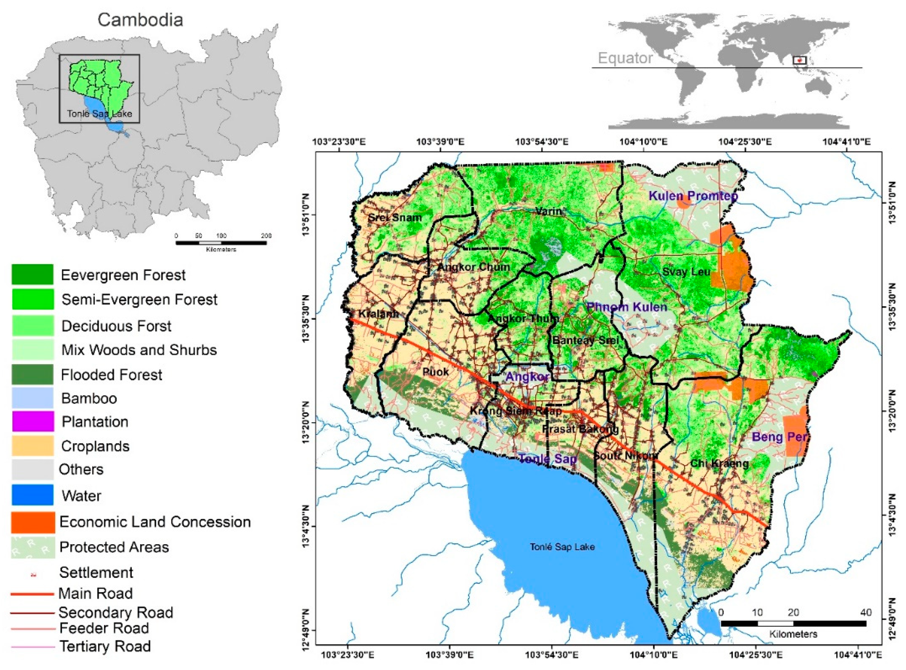
Figure 2.
Methodological framework for identification of degraded forests for restoration and related carbon sequestration.
Figure 2.
Methodological framework for identification of degraded forests for restoration and related carbon sequestration.
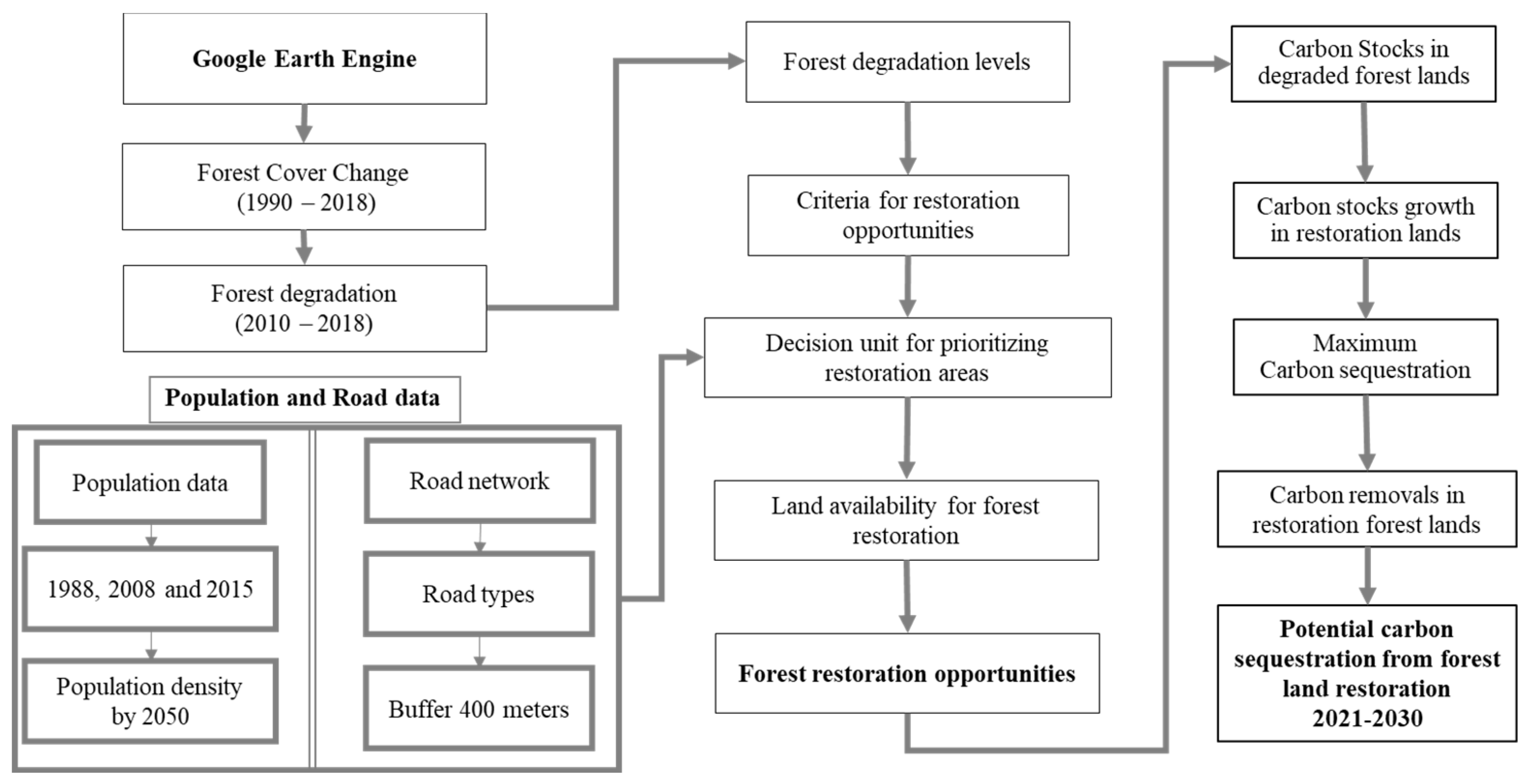
Figure 4.
Forest cover change between 1990 and 2018: A to G represent forest cover from 1990 to 2018 and H shows forest degradation from 2010 to 2018.
Figure 4.
Forest cover change between 1990 and 2018: A to G represent forest cover from 1990 to 2018 and H shows forest degradation from 2010 to 2018.
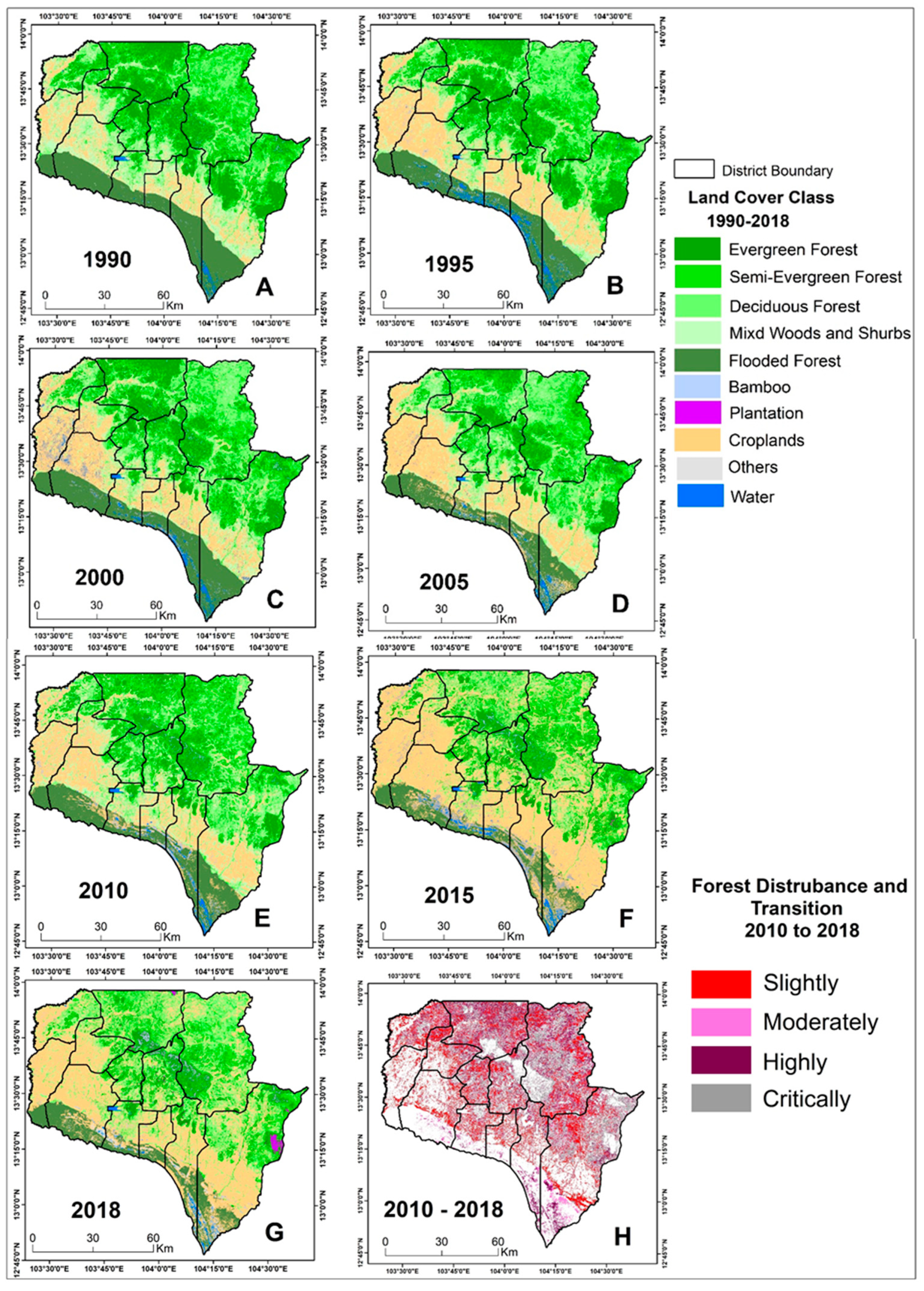
Figure 5.
Forest transition and level of forest degradation maps of Siem Reap province: a Population density and road network data in the study area, b Forest cover in 2018 and predicted 2050 population density, c Forest degradation levels before the framework, d Forest degradation levels after applying the PDFR framework and recommended restoration areas to achieve the maximum carbon stock levels.
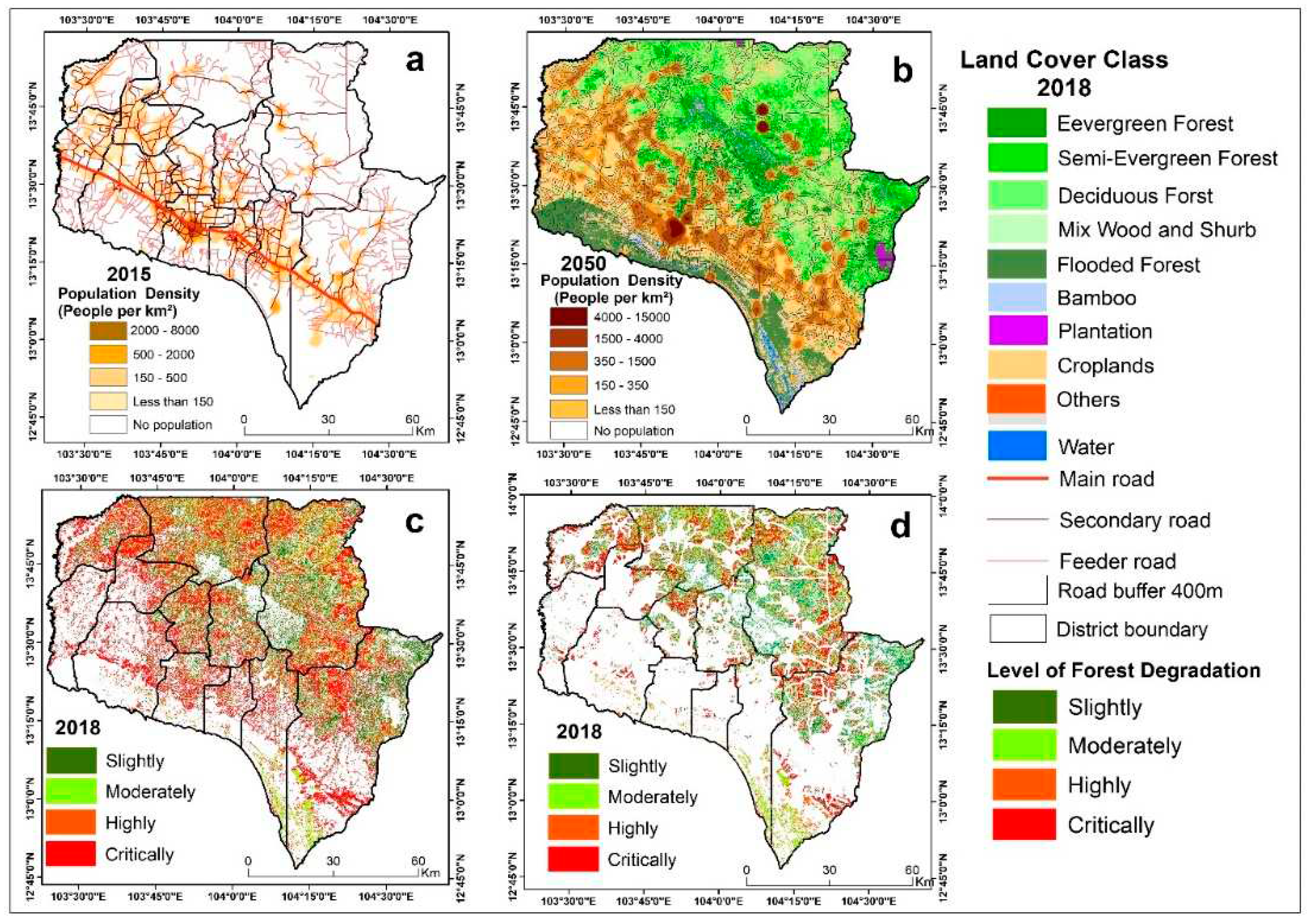
Figure 6.
Map of areas in Siem Reap Province prioritized for forest restoration according to the level of forest degradation. The colored areas show the potential degraded forests for restoration.
Figure 6.
Map of areas in Siem Reap Province prioritized for forest restoration according to the level of forest degradation. The colored areas show the potential degraded forests for restoration.
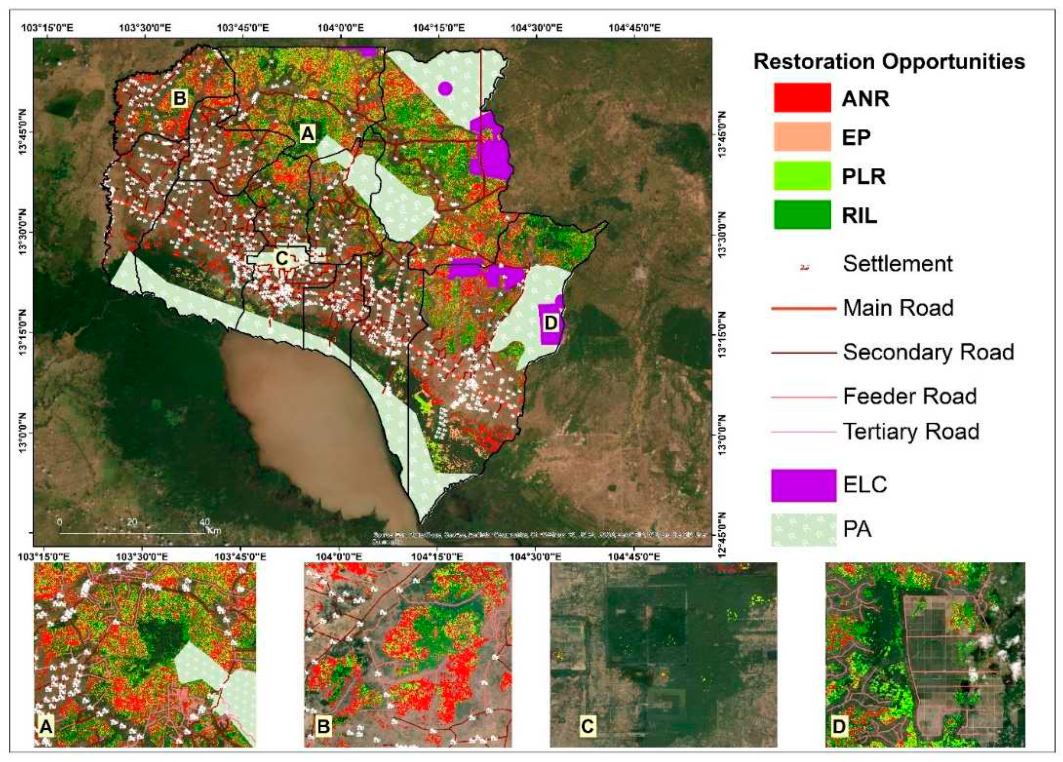
Figure 7.
Mapping of strategies for the New York Declaration on Forests Restoration as applied to the Siem Reap province forest landscape (Source: Authors).
Figure 7.
Mapping of strategies for the New York Declaration on Forests Restoration as applied to the Siem Reap province forest landscape (Source: Authors).
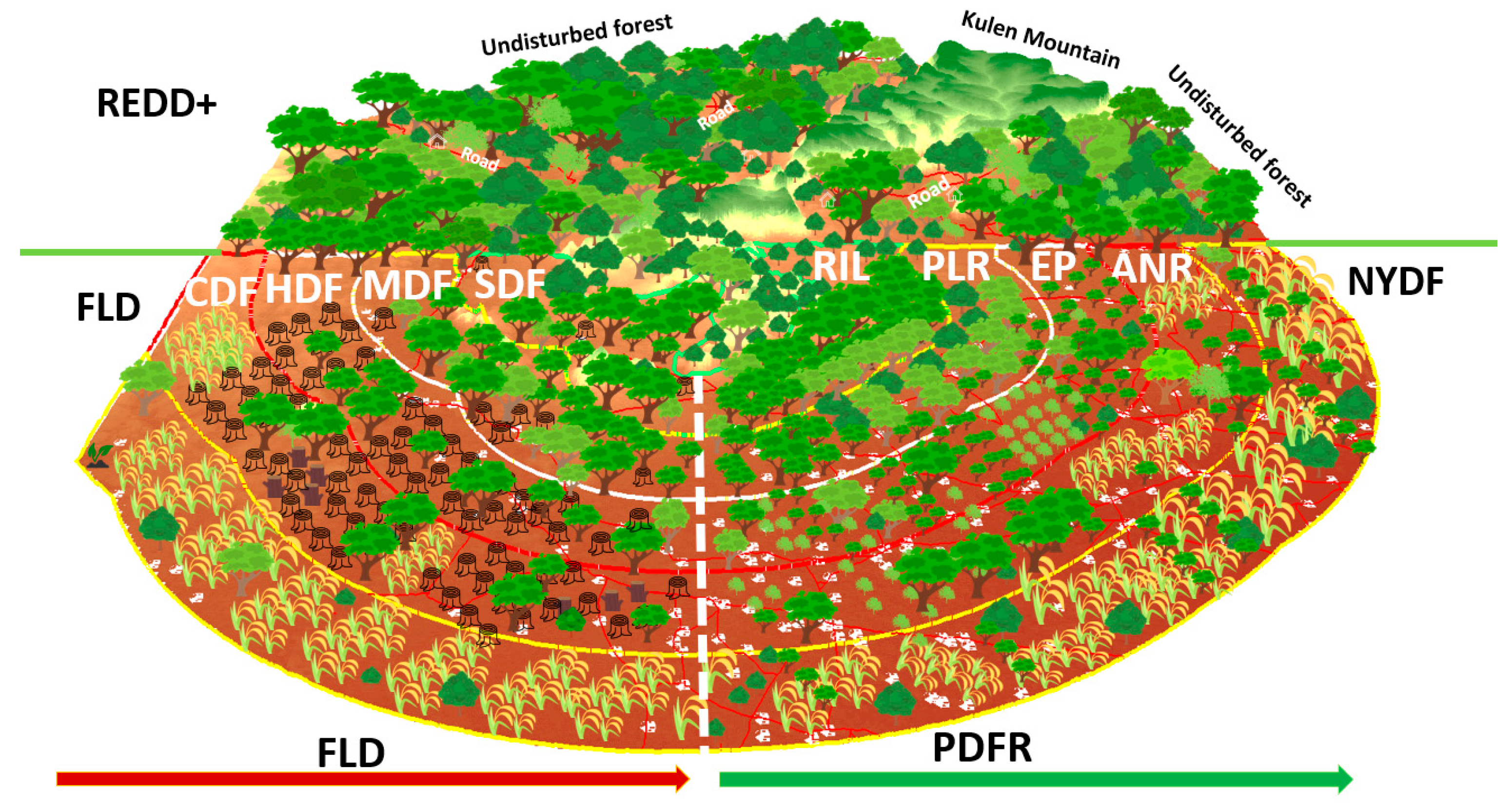
Figure 8.
Potential above-ground carbon stock growth over time in the proposed restoration forest lands in Siem Reap province under the four PDFR strategies: the ANR curve represents the time to achieve the maximum carbon stock using the assisted naturally regenerated restoration approach, the EP curve represents the enrichment planting approach, the PLR curve shows the time required under the preventing logging reentry strategies and the RIL curve depicts the time required with reduced impact logging.
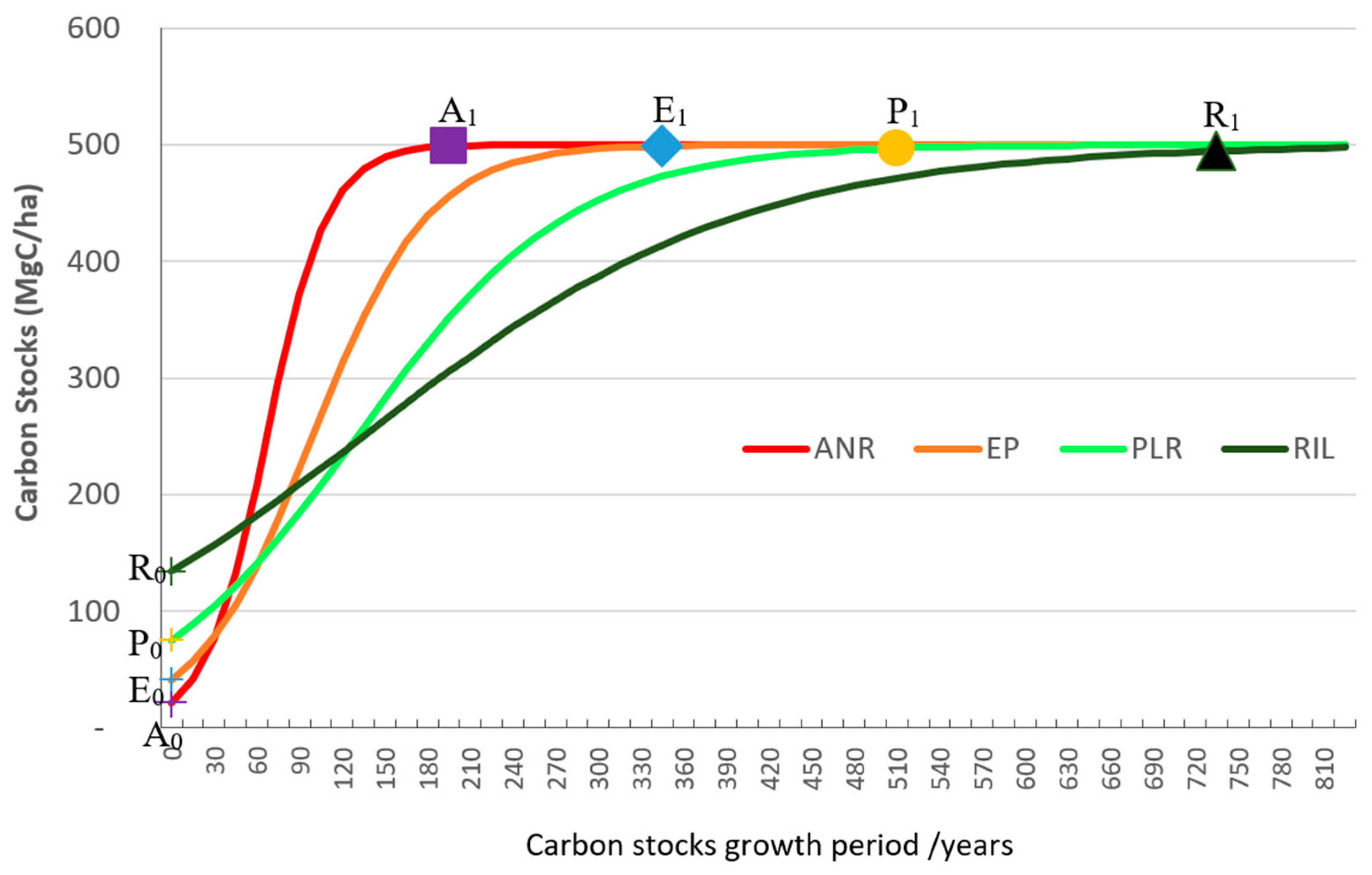
Figure 9.
Potential carbon sequestration (million tons) between 2021 and 2030 from the proposed restoration strategies in Siem Reap province. Note: ANR = assisted naturally regenerated restoration, EP = enrichment planting, PLR = preventing logging reentry, and RIL = reduced impact logging.
Figure 9.
Potential carbon sequestration (million tons) between 2021 and 2030 from the proposed restoration strategies in Siem Reap province. Note: ANR = assisted naturally regenerated restoration, EP = enrichment planting, PLR = preventing logging reentry, and RIL = reduced impact logging.
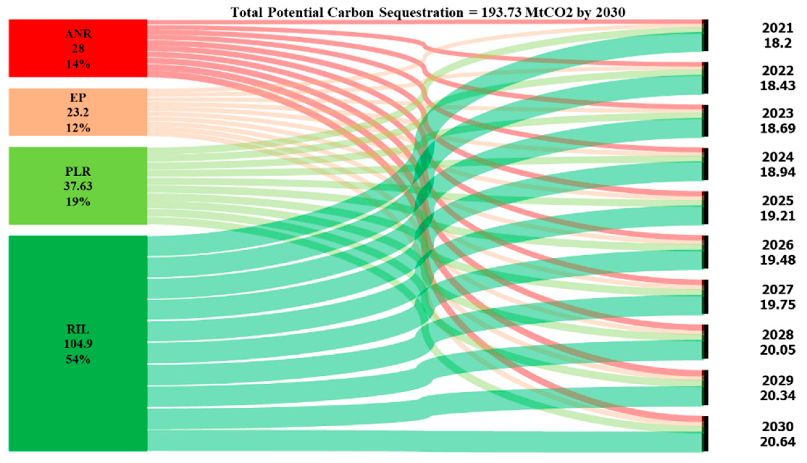

Table 1.
Weighting system, assessment score, and restoration strategy for restoration of degraded forests.
Table 1.
Weighting system, assessment score, and restoration strategy for restoration of degraded forests.
| Original PDFR dataset category | FA degradation priority |
Assessment score | Constraint | Restoration Strategy* | AGC (MgC ha-1) |
|---|---|---|---|---|---|
| Critically degraded forest | High (4) | 4 x 1.5 = 5.5 | - Suitable land use should be degraded forest land. - Forest restoration land should not be within a rubber plantation. - Forest restoration land should not be within 400 m of all road types. - Forest restoration land should not be within the 2050 predicted population density radius. |
Assisted natural regeneration | 27 |
| Highly degraded forest | High (3) | 3 x 1.5 = 4.5 | Enrichment planting | 32 | |
| Moderately degraded forest | Medium (2) | 2 x 1.5 = 3.5 | Preventing logging reentry | 60 | |
| Slightly degraded forest | Slightly (1) | 1 x 1.5 = 2.5 | Reduced impact logging | 148 | |
| Not degraded | Eliminated (0) | 0 x 0 = 0 | Restoration is not needed |
Note 1: * adopted from Sasaki et al. [12]. Note 2: The weighted assessment score was applied based on the level of forest degradation over 8 years and the weighted system was applied based on the potential opportunity for forest restoration. PDFR = potential degraded forests for restoration and AGC = Above-ground carbon stocks (MgC ha-1) in degraded forests. The weighted and assessment scores were applied for best area selection and suitability assessment [20].
Table 2.
Forest cover and rate of forest cover change in Siem Reap province.
| Forest Category | Total Forest Area (ha) | 1990-2018 | 2010-2018 | ||||||||||
| 1990 | 1995 | 2000 | 2005 | 2010 | 2015 | 2018 | Change (ha) | Annual Change (ha) | Rate of Change (%) | Change (ha) | Annual Change (ha) | Rate of Change (%) | |
| Evergreen | 188,332 | 186,923 | 178,249 | 157,350 | 142,451 | 127,240 | 91,254 | -97,078 | -3,467 | -0.018 | -51,197 | -2,844 | -0.020 |
| Semi-evergreen | 162,797 | 159,084 | 151,325 | 144,430 | 143,221 | 116,251 | 104,529 | -58,268 | -2,081 | -0.013 | -38,692 | -2,150 | -0.015 |
| Deciduous | 240,205 | 232,976 | 233,940 | 228,943 | 226,331 | 181,153 | 173,010 | -67,194 | -2,400 | -0.010 | -53,321 | -2,962 | -0.013 |
| Wood and Shrubland | 130,876 | 127,360 | 121,764 | 136,065 | 146,432 | 67,562 | 68,782 | -62,095 | -2,218 | -0.017 | -77,650 | -4,314 | -0.029 |
| Bamboo | 6,162 | 5,600 | 5,211 | 7,768 | 8,364 | 7,276 | 8,865 | 2,703 | 97 | 0.016 | 501 | 28 | 0.003 |
| Flooded Forest | 141,083 | 140,331 | 130,415 | 112,502 | 107,614 | 79,966 | 79,662 | -61,420 | -2,194 | -0.016 | -27,952 | -1,553 | -0.014 |
| Rubber | 0 | 0 | 0 | 388 | 2,677 | 6,219 | 20,658 | 20,270 | 1,559 | 4.019 | 17,981 | 999 | 0.373 |
| Total | 869,454 | 852,274 | 820,903 | 787,446 | 777,090 | 585,666 | 546,760 | -322,694 | -11,524 | -0.013 | -230,330 | -12,796 | -0.016 |
Table 3.
Definitions and possible interventions for restoring degraded forests.
| Terms | Definition and intervention |
|---|---|
| FLD | Forest land degradation zone refers to the reduction of a forest area’s capacity to provide the full suite of forest ecosystem services, such as biodiversity, carbon, or hydrological services [13]. Tropical forests are degraded in a way that reduces tree cover and carbon stocks through the removal of trees or woody material (e.g., logging or infrastructure construction, shifting cultivation, and harvesting trees for charcoal production) or through the collection of non-timber forest products [57,58,59]. Categorizing forests based on FLD levels; SDF = Slightly degraded forest, MDF = Moderately degraded forest, HDF = Highly degraded forest, CDR = Critically degraded Forest (Figure 3) can aid in preparing guidelines for critical decisions [12] concerning the priorities and strategies for forest restoration (Figure 7). |
| NYDF | New York Declaration on Forest. Two of the declaration’s goals are to end natural forest loss and restore forests by 2030 [2,10,15]. Further goals include the promotion of sustainable and equitable development by supporting livelihoods that do not result in further deforestation [3,14]. The PDFR model suggests selecting from among four approaches (ANR, EP, PLR, and RIL). This should provide more assurance of the success of the NYDF goals with low financial costs, better biodiversity, and social environmental benefits (Figure 7). If proper restoration, protection, and forest management initiatives are not implemented, then the FLD may continue and pose serious environmental and socioeconomic problems that adversely affect people who depend on forest products and services. |
| PDFR | The potential degraded forests for restoration model refer to the process of assisting the restoration of forest land that has been degraded, damaged, or destroyed. The aim of the PDFR is to improve forest ecosystem services, such as biodiversity and carbon sequestration using defined strategies to meet NYDF goals 1 and 5 by 2030 (Figure 7). |
| REDD+ | REDD+ refers to the incentive mechanism defined under the UNFCCC to reduce emissions from deforestation and forest degradation, effect the conservation and sustainable management of forests, and enhance forest carbon stocks [60,61,62,63]. Introducing the REDD+ result-based financial scheme can combat deforestation and forest degradation in the tropics where most forest disturbance takes place. If REDD+ activities are implemented where native forests are still intact or undisturbed, about 8,256,746 MgCO2 of carbon emissions could be reduced in the Siem Reap province by 2030 [31]. If interventions (REDD+ or forest land restoration under the NYDF) are not implemented, then deforestation and forest degradation emissions are likely to continue. This may initially occur along roads and surrounding settlements, and may extend into undisturbed and mountain forest lands (Figure 7). |
Table 4.
Conservative estimated costs for forest land restoration in Siem Reap province.
| Degraded Forests by Levels | Restoration Strategies | PDFR | |
|---|---|---|---|
| Forest Area (ha) | Costs (US$ Millions) | ||
| Critically degraded forest | Assisted natural regeneration | 96,693 | 193.39 |
| Highly degraded forest | Enrichment planting | 48,878 | 97.76 |
| Moderately degraded forest | Preventing logging reentry | 46,487 | 92.97 |
| Slightly degraded forest | Reduced impact logging | 75,567 | 151.13 |
| Total | 267,625 | 535.25 | |
Note: The cost of restoration (US$ 2000 per hectare) for the PDFR opportunities was estimated according to Löf et al. [23].
Table 5.
Initial above ground carbon stocks in degraded forest lands in Siem Reap province in 2018.
| Forest Forest degradation level |
PDFR | |
| Forest Area (ha) | AGC (MgC yr-1) | |
| Critically degraded forest | 96,693 | 2,088,570 |
| Highly degraded forest | 48,878 | 2,003,989 |
| Moderately degraded forest | 46,487 | 3,495,838 |
| Slightly degraded forest | 75,567 | 10,125,939 |
| Total | 267,625 | 17,714,336 |
Note: AGC = Above ground carbon stocks per year (2018) in degraded forest lands. PDFR = Potential degraded forests for restoration.
Disclaimer/Publisher’s Note: The statements, opinions and data contained in all publications are solely those of the individual author(s) and contributor(s) and not of MDPI and/or the editor(s). MDPI and/or the editor(s) disclaim responsibility for any injury to people or property resulting from any ideas, methods, instructions or products referred to in the content. |
© 2023 by the authors. Licensee MDPI, Basel, Switzerland. This article is an open access article distributed under the terms and conditions of the Creative Commons Attribution (CC BY) license (http://creativecommons.org/licenses/by/4.0/).
Copyright: This open access article is published under a Creative Commons CC BY 4.0 license, which permit the free download, distribution, and reuse, provided that the author and preprint are cited in any reuse.


