Submitted:
20 September 2023
Posted:
21 September 2023
You are already at the latest version
Abstract
Unmanned aerial vehicles (UAV) have emerged as a solution to day to day survey tasks, allowing users to visualize phenomena in real-time. This paper explores the capabilities of UAV or drones in the collection of accurate, geo-tagged data quickly, including photogrammetry software processes to deliver standardized data output. In order to explore the capabilities of UAV, Gatu Township in Centenary, Muzabani District of Zimbabwe was chosen from the national mapping topographic series. This study demonstrates the efficiency of data collection using drones, generate 2D orthomosaics in real time, so that analysts can easily visualize land cover and identify any changes, map and model large areas to produce data for 2D and 3D models. The recent development of innovative optical image processing has further lowered the costs high resolution topographic surveys.
Keywords:
photogrammetry
; unmanned aerial vehicles (UAV)
; 3D point cloud
; geographic information systems (GIS)
1. Introduction
This article provides an overview on drone survey or photogrammetry, unmanned aerial vehicle (UAV)/drone preparation, and the end products of image processing which include orthomosaic, 3D point cloud and Contour map. UAV/drone is an aircraft flown remotely from the ground by way of a preplanned flight plan, whilst 3D point cloud is 3D geometric information, mainly acquired through laser scanning and photographic survey technologies to generate digital surface models (DSM), digital elevation models (DEM) and digital terrain models (DTM) (MMRICS, 2019).
Various benefits of drone photogrammetry have been noted by various scholars in the recent decades. These include managing land cover and land use change, allowing users to visualize results immediately using real-time orthomosaics or high resolution maps during post processing (Drone Industry Insights, 2021). The use of affordable drone and image processing software solutions that automate data collection and processing has been noted as viable, reducing the costs associated with field work and inaccessible remote areas or locations with obstructions (ESRI, 2022).
Photogrammetry produces maps directly from photographic images by identifying, symbolizing, and capturing elevation manmade and natural features visible on the imagery (Duffy, 2021) providing GIS with essential information. As a result, the use of drones and related image processing software help to keep records that can easily be used for regular land cover comparisons so that users can monitor changes dynamically.
2. Literature Review: Overview on Drone Application
Planning a survey generally starts with collecting available geographic information about the area of interest. However, the process of finding and incorporating this data from multiple sources is time consuming, even if available online. In that regard, the uses of drones has gained momentum, aided by reduced costs and increase the reliability of the technology. This section focuses on the potential uses of drones, their benefits and limitations.
2.1. Drone Application
Drone surveys can be used for various purposes, including; dams and bridges inspections (Seo, et al. 2018), land surveying (MRICS, 2019); construction monitoring (Navid et al. 2018), slope monitoring (Gómez & Pabón, 2021; Cho et al. 2022) and urban traffic monitoring (Valentin & Boboc, 2022).
A desktop application for GIS drone mapping such as ArcGIS Drone2Map software has been used to capture drone data using site scan flight or any third party drone data collection app (ESRI, 2022). After the flight, the user creates a project to download the drone imagery. Ground control points are added and 2D and 3D outputs are processed and created. With the 2D or 3D outputs, measurements can be made, changes tracked, and other analysis can be made. Advanced analysis can also be done in ArcGIS Pro, utilizing a range of tools such as advanced spatial, temporal and spectral analysis, as well as data management (ESRI, 2022).
2.2. Benefits of Drone Survey
2.2.1. Improved Quality and Accuracy:
Drones are essential due to their ability to capture reality, that is, images with coordinates and elevation, thereby ensuring quality through capturing many images and the use of sensors such LIDAR, infrared cameras and multi-spectral sensors (MRICS, 2019). Software such as Pix4D allows users to add ground control points (GCPs) to help improve data accuracy.
2.2.2. Cost Effective
The use of AUV or drones saves costs, reducing the need for several surveyors and costs related to ground surveying, including the software used for drone surveying.
2.2.3. Saving Time
Given that drones make it easier to convey data in real-time, while automation of data processing and export is also made easier (ESRI, 2022) by software such as DroneDeploy, Pix4D, and thereby allowing users to save time and costs.
2.2.4. Improved Work Safety and Coverage
Given that drones are controlled remotely, they are safer to use, and have the ability to reach inaccessible areas, including areas dangerous to human life.
2.2.5. Drone Analytics
Drones allow users to view the natural color, thermal infrared or multispectral datasets, perform 2D and 3D measurements such terrain and spectral profiles, as well as volumetric calculations, which allow quick data analysis (Duffy, 2021).
2.2.6. Integration with other GIS Software
Image processing software is part of GIS system, which provides access to tools for geospatial analysis. As such, end products from drone software can be exported and opened easily in ArcGIS desktop or ArcGIS Pro for integrated management. ArcGIS Online or ArcGIS Enterprise can also be utilized to publish or share the imagery data products and their elevation datasets (Seo et al. 2018).
3. Study Area, Materials and Methodology
3.1. Study Area
The study was conducted at micro-scale using drone or unmanned aerial vehicle (UAV). Images were taken from Gatu T/Ship located in Centenary, Muzarabani District, between latitude -16°43´22.40´´ S and longitude 31°06´ 52.63´´ E.
3.2. Materials
Dji Phantom4 drone, Google Earth Pro, Pix4D mapper version 4.7.5 and ArcGIS 10.8 were used in the study. ArcGIS is geographic information software which allows users to manipulate and present data from Pix4D further.
3.3. Methodology
The study consists of five stages (Figure 1) which are: pre-survey, drone preparation, data acquisition, image processing and further processing with ArcGIS.
3.3.1. Pre-Survey using Google Earth Pro
Various people have used Google Earth to search for a famous landmark or their location address; however, many surveyors have utilized the online database as a valuable tool for visualizing the layout and terrain of any area or region of interest (Duffy, 2021). Therefore combining satellite, aerial, 3D, and Street View images, Google Earth provides access to a wealth of knowledge remotely.
In order to generate the boundary for the study, Muzarabani District topographic map from the Surveyor General Department was used for the study. The topographic map was digitized and georeferenced in QGIS and Gatu Township was selected for the study. A KML file for the township boundary was also created in Google Earth Pro as indicated in Figure 2 below.
The ability to survey site virtually is a major advantage of Google Earth Pro which has become an integral part of GIS and surveying. Thus surveyors can make use of the area of interest from satellite images and aerial photos, and enhance the view with GIS information, thereby preparing a cost estimate and survey plan based on real-time data available. Google Earth’s range of capabilities includes zooming through multi-resolution imagery, measuring linear distance and area, overlaying section lines and boundaries, and geo-tagging photos (Liping, 2022). Google Earth allows surveyors to identify access points, survey marks, obstacles and vegetation coverage which influence cost estimates, helping to schedule the necessary people and equipment.
3.3.2. Drone Preparation
Weather was checked before flying a drone, to make sure there was no rain, fog, snowfall, or strong winds on the day, and ground points were set up. The control points were distributed throughout the study area. Overlap and flight mode were also set up, with a sweeping flight path back and forth over the entire site. Survey flight plan was created by importing a KML file of the area under study. After pressing the take-off button, the drone took off autonomously and captured 118 images.
3.3.3. Image processing with Pix4D Mapper
After the drone flight, images were uploaded to post-processing software (Pix4D mapper) that generates a 2D, 3D map or an orthomosaic map. Images taken from the drone, 118 in total, were uploaded in the software for processing. Collected images were checked for radiometric distortions.
3.3.4. Image Properties
On image properties, Geolocation Accuracy was set as “Standard” and coordinate system as “WGS 1984”. The Output Coordinate System was set at “Auto-detected WGS 84/UTM Zone 36S and processing template as “Standard - 3D Maps. During initial processing the following tiers were generated as shown in Table 1 below.

Table 1.
Tiers generated during pre-processing in Pix4D.
| Image Scale | Multiscale, 1/4 (Quarter image size, Fast) |
|---|---|
| Point Density | Low (Fast) |
| Minimum Number of Matches | 3 |
| 3D Textured Mesh Generation | Yes |
| 3D Textured Mesh Settings: | Resolution: Medium Resolution (default) Colour Balancing: no |
| Advanced: 3D Textured Mesh Settings | Sample Density Divider: 1 |
| Advanced: Image Groups | group1 |
| Advanced: Use Processing Area | Yes |
| Advanced: Use Annotations | Yes |
| Time for Point Cloud Densification | 04m:52s |
| Time for Point Cloud Classification | 01m:50s |
| Time for 3D Textured Mesh Generation | 03m:46s |
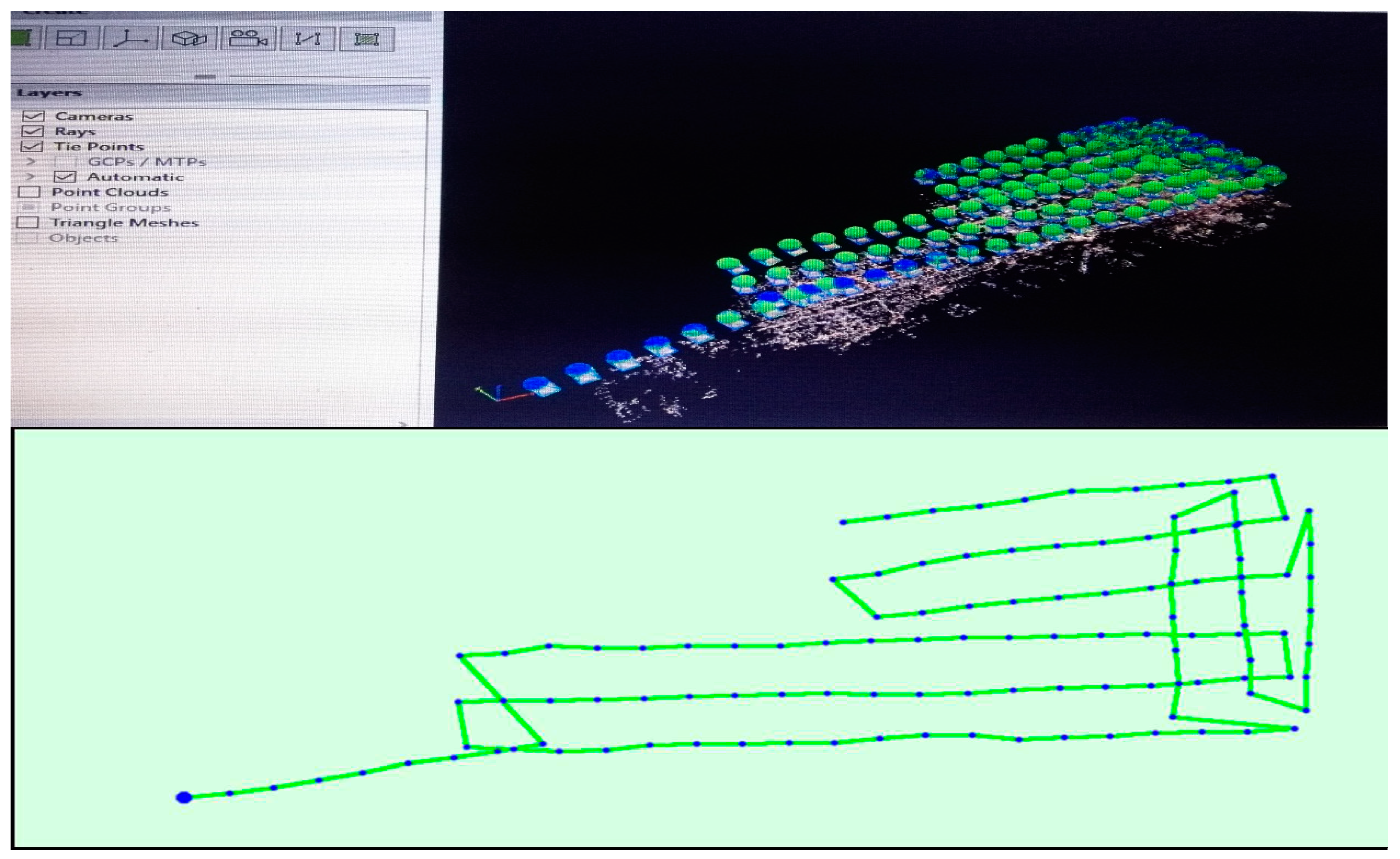
3.3.5. Computed Images/GCPs/Manual Tie Points Positions
From Figure 3 above, the green line follows the position of the images in time starting from the large blue dot (Pix4D).
4. Results and Discussion
4.1. Orthomosaic and Overlapping images
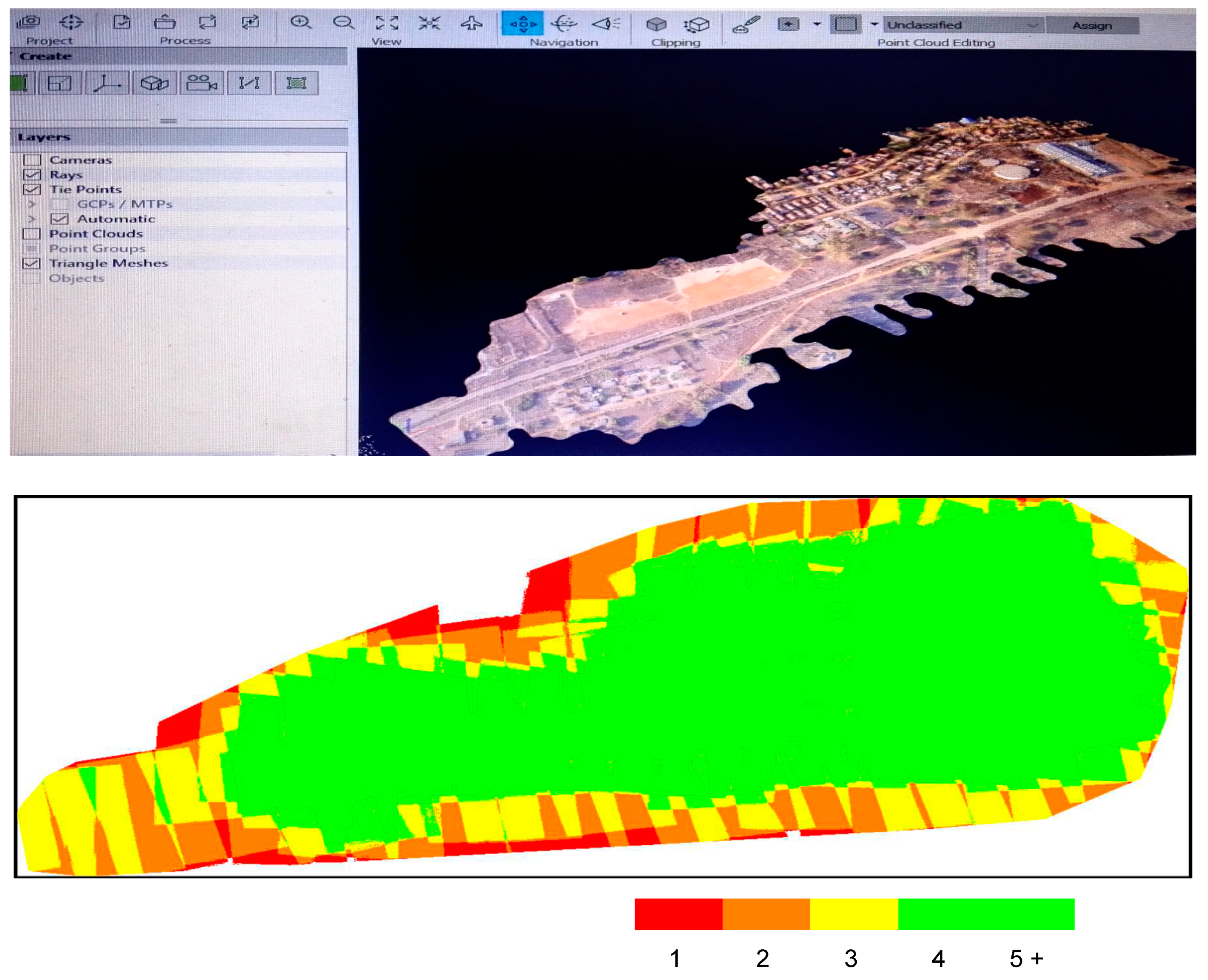
4.2. 3D textured mesh
The 3D textured mesh is a reproduction of the edges, faces, vertices and texture of the area captured by the UAV. The model is useful for visual inspections and external stakeholder involvement.
4.3. Integration with GIS
This study demonstrates the integration of drone survey software with GIS, as shown in Figure 5 below, by generating contour map of the study area.
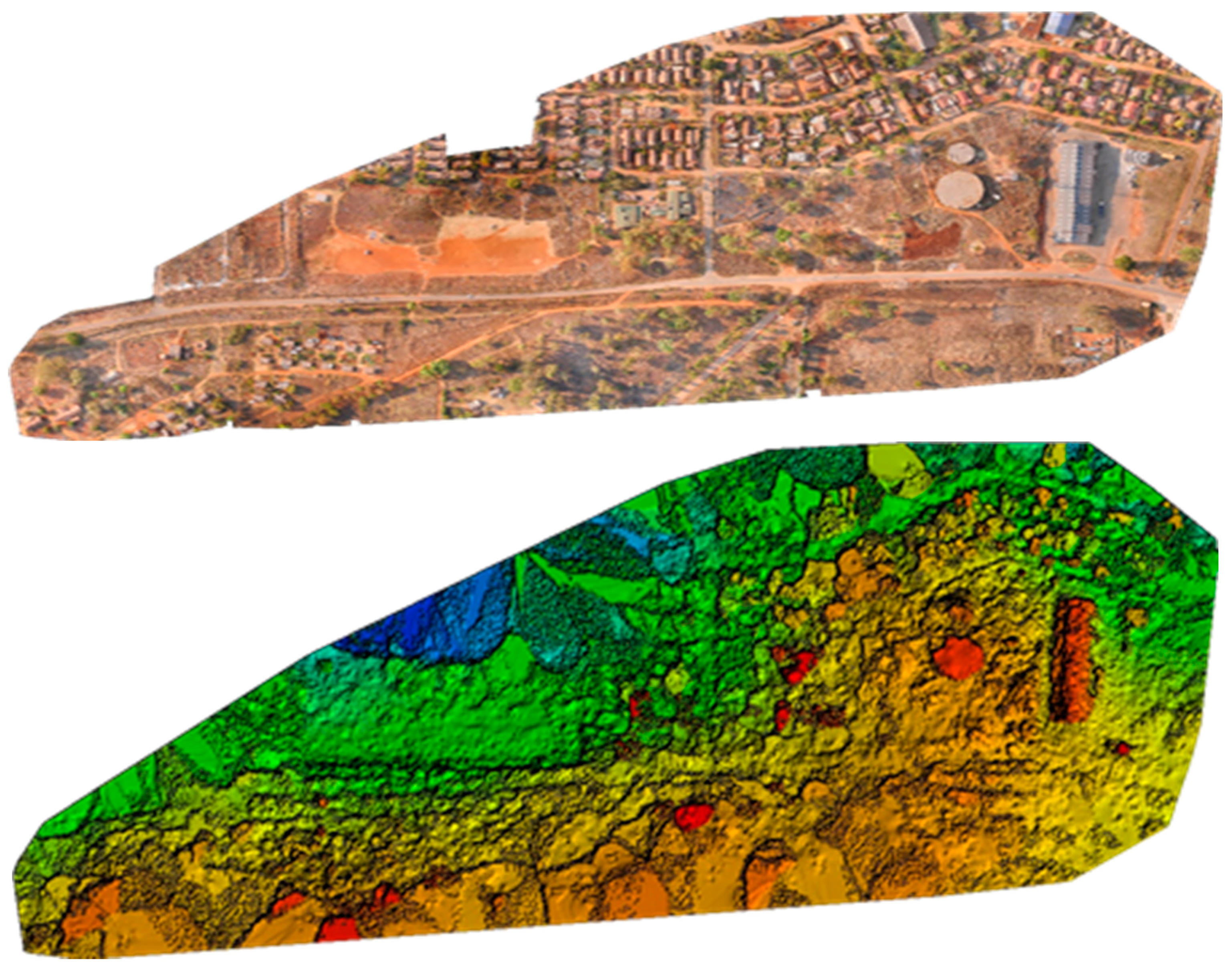
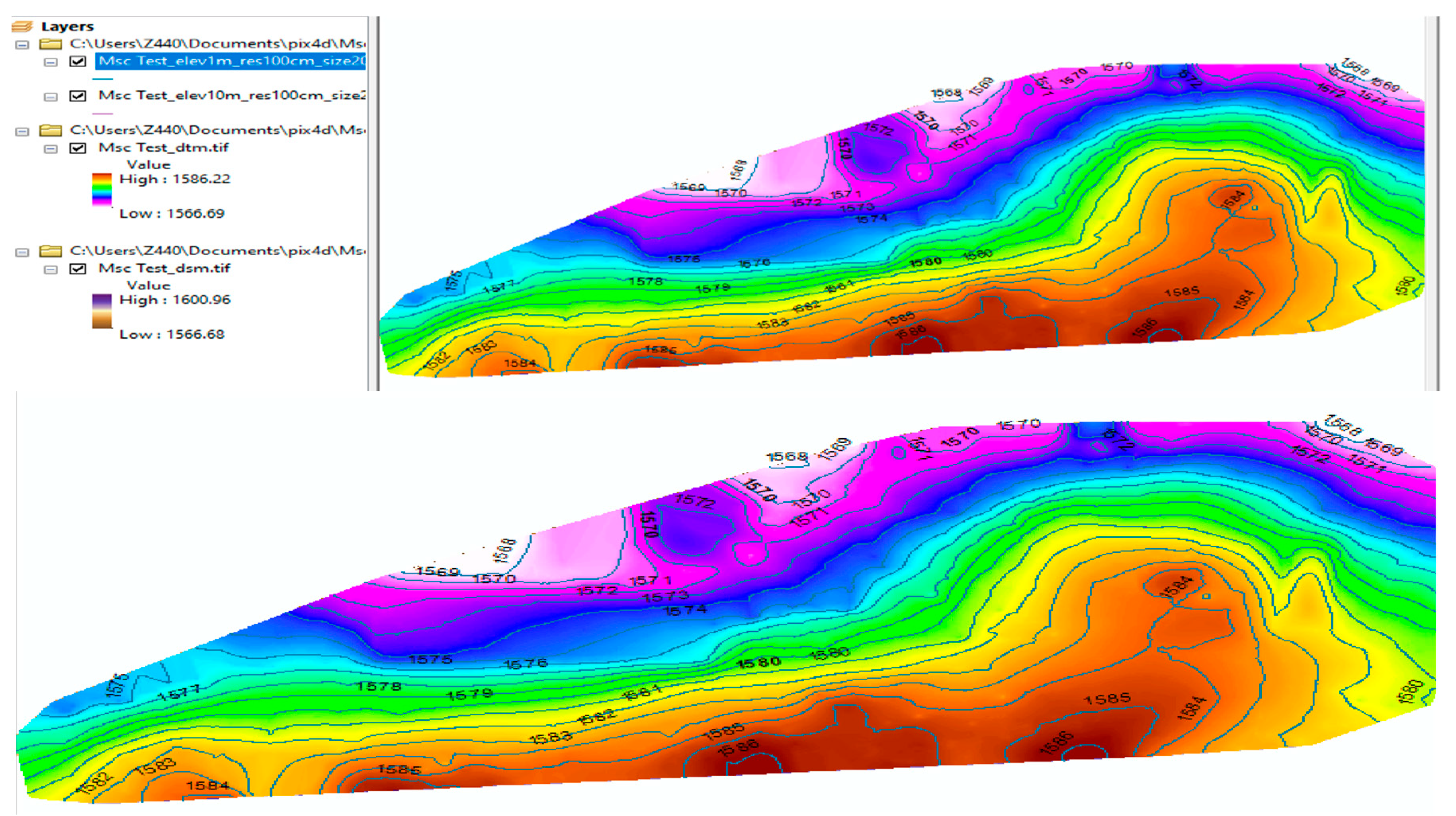
Figure 5.
Textured mesh and orthomosaic in Pix4D.
Figure 5.
Contour map in ArcGIS 10.8 Desktop.
The DSM model generated by Pix4D was exported into ArcGIS desktop 10.8, creating contour lines map, providing the user with better understanding of the surface of the area captured by the drone. By exporting the DSM into ArcGIS, contours with elevation of 10m and resolution 100cm were generated.
5. Conclusion
In this study, a survey was performed to explore the capabilities of UAV. Focus was on drone preparations, image capture, image processing using Pix4D, drone imagery end products and integration with GIS for further analysis. Also noted were the application of drone survey ranging from dams and bridges inspections, land surveying, construction monitoring to slope monitoring. From this study, it is noted that digital photogrammetry permits the reconstruction of topography using algorithms that can provide 3D spatial information of phenomena. Further researches may focus on analyzing how drones could help in explore vacant land and safe zones in the study area.
Acknowledgments
The article is dedicated to Geomatics Engineers and Geospatial Analysts, with special thanks to the University of Zimbabwe for surveying instruments and permission to use photographs and data.
Declaration of competing interest
The author declares that there are not that could have influenced the work in this paper.
References
- Butilă, E. V., & Răzvan, G. B., 2022. Urban Traffic Monitoring and Analysis Using Unmanned Aerial Vehicles (UAVs): A Systematic Literature Review: Remote Sensing 14, no. 3: 620. [CrossRef]
- Cho, J., Lee, J. & Lee, B., 2022. Application of UAV Photogrammetry to Slope-Displacement Measurement. KSCE Journal of Civil Engineering 26, 1904–1913. [CrossRef]
- Drone Industry Insights, 2021. Drone Application Report: Benefits of drone survey. Available from: https://droneii.com/product/drone-application-report.
- Duffy, L., 2021. Engineering News Record (ENR). Fundamentals of Surveying. How Surveyors Make the Most of Google Earth: Easy access to geographic information a plus for project planning. Available from: https://www.enr.com/articles/53269-how-surveyors-make-the-most-of-google-earth.
- ESRI, 2022. ArcGIS Drone2Map: Robust GIS drone mapping software. Available from: https://www.esri.com/en-us/arcgis/products/arcgis-drone2map/overview.
- Gómez, L.A., & Pabón, S.B., 2021. Using Drones and Remote Sensing for Slope Monitoring: a Review. Available from: https://api.semanticscholar.org/CorpusID:244113439.
- MRICS, P.K. (2019). Drones: Applications and Compliance for Surveyors. Insight Paper. Available from: https://www.MRICS.org/content/dam/MRICSglobal/documents/to-be-sorted/drones-applications-and-compliance-for-surveyors-MRICS.pdf.
- Naveed, A., Fawad, N., & Muhammad, A.I., 2018. Construction Monitoring and Reporting using Drones and Unmanned Aerial Vehicles (UAVs). The Tenth International Conference on Construction in the 21st Century (CITC-10) July 2nd -4th, 2018, Colombo, Sri Lanka. https://www.researchgate.net/publication/326264559_Construction_Monitoring_and_Reporting_using_Drones_and_Unmanned_Aerial_Vehicles_UAVs/link/5b42f727aca2728a0d6545ea/download].
- Seo, J., Duque, L., & Wacker, J., 2018. Drone-enabled bridge inspection methodology and application: Automation in Construction, Volume 94, Pages 112-126, ISSN 0926-5805. [CrossRef]
- Liping, Y., Driscol, J., Sarigai, S., Wu, Q., Chen, H., & Lippitt, C.D., 2022. Google Earth Engine and Artificial Intelligence (AI): A Comprehensive Review. Remote Sensing 14, no. 14: 3253. [CrossRef]
Figure 1.
Workflow for drone survey.
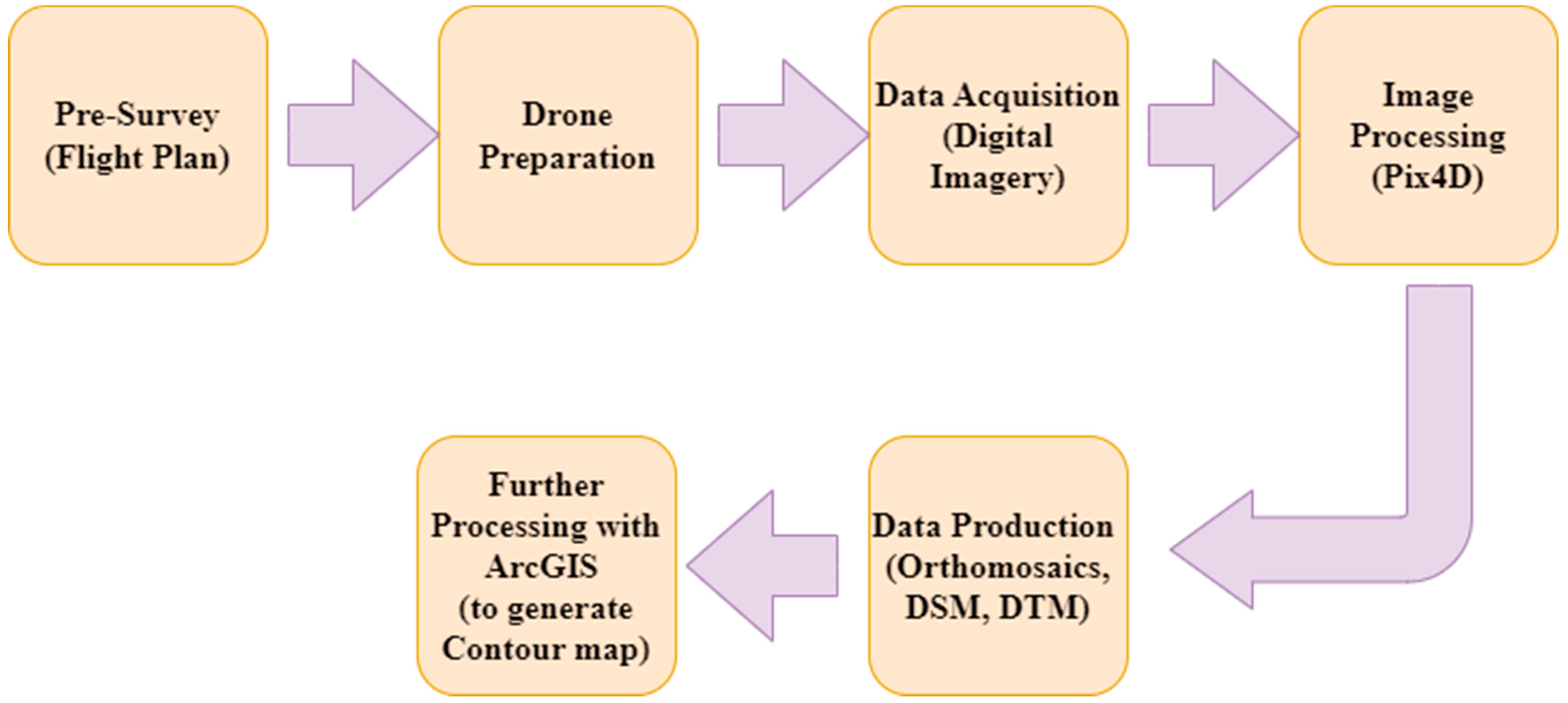
Figure 2.
Georeferenced Topographic map in QGIS and the generated polygon of the study area in Google Earth Pro.
Figure 2.
Georeferenced Topographic map in QGIS and the generated polygon of the study area in Google Earth Pro.
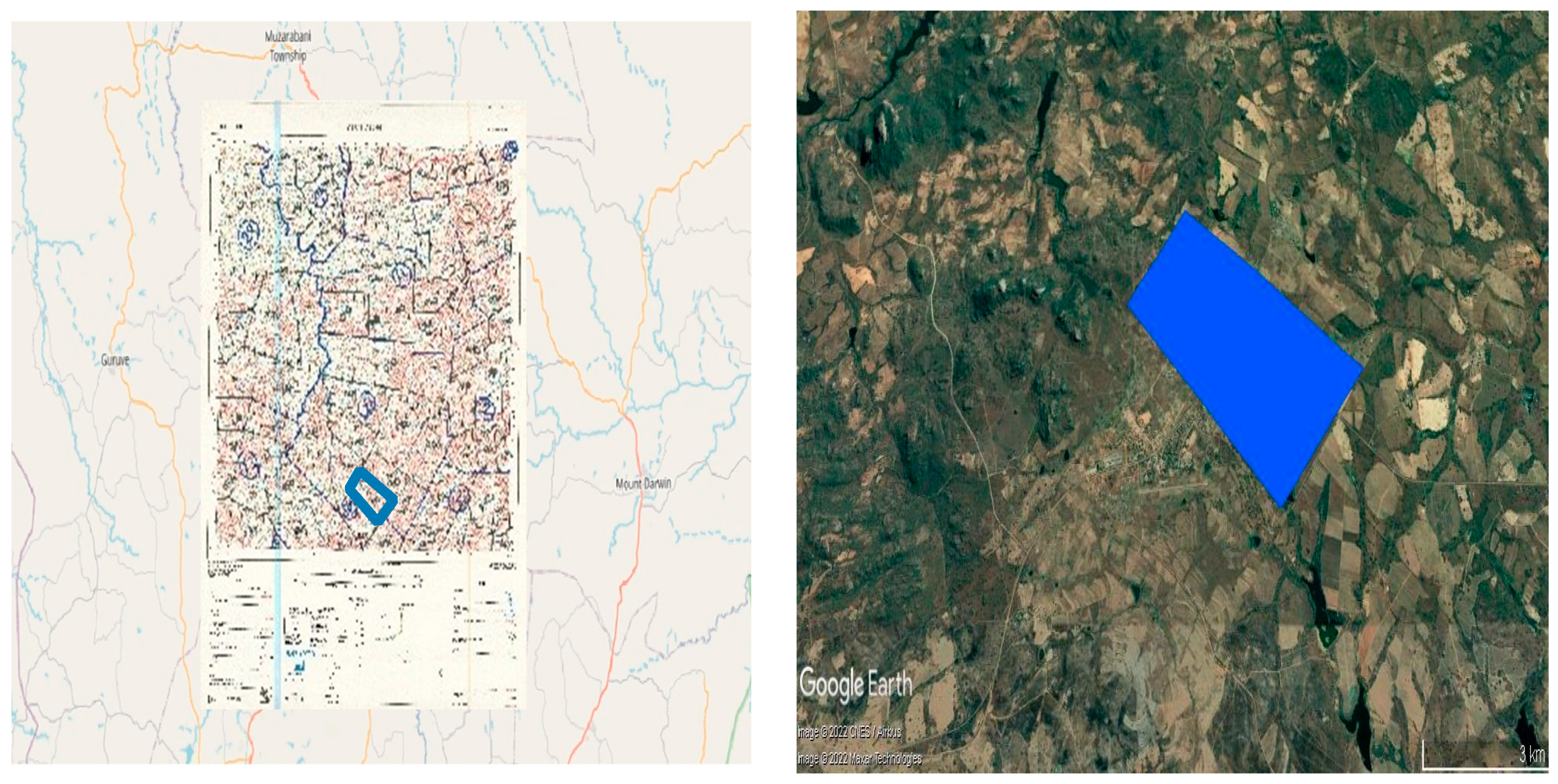
Figure 3.
The top view of the initial image position in Pix4D.
Disclaimer/Publisher’s Note: The statements, opinions and data contained in all publications are solely those of the individual author(s) and contributor(s) and not of MDPI and/or the editor(s). MDPI and/or the editor(s) disclaim responsibility for any injury to people or property resulting from any ideas, methods, instructions or products referred to in the content. |
© 2023 by the authors. Licensee MDPI, Basel, Switzerland. This article is an open access article distributed under the terms and conditions of the Creative Commons Attribution (CC BY) license (http://creativecommons.org/licenses/by/4.0/).
Copyright: This open access article is published under a Creative Commons CC BY 4.0 license, which permit the free download, distribution, and reuse, provided that the author and preprint are cited in any reuse.


