
Submitted:
20 September 2023
Posted:
28 September 2023
You are already at the latest version
Abstract
Remote sensing (RS) as a landscape planning and management tool for socio-cultural diversity and inclusiveness in protected(reserved) areas through monitoring of the land-use changes, settlement/living patterns, predominant trades/socio-economic activities in the urban-rural locations, and the demography in Sub-Saharan Africa (SSA). The eighteen federal governments recognized nature reserves in Nigeria being the giant of Africa because of their green landscapes, rich biodiversity, and human resources. This study aimed to explore the application of remote sensing to assess the extent of land degradation and encroachment in the 18 recognized national parks in Nigeria. A review of the protection of national parks using remote sensing and monitoring the trend of national park invasions which could either be natural or man-made. The study is in line with the United Nations SDG Goal 15: Life on Land- “Protect, restore and promote sustainable use of terrestrial ecosystems, sustainably manage forests, combat desertification, and halt and reverse land degradation and halt biodiversity loss”. Located in the West Africa subregion lying on Latitude: 9° 04' 39.90" N (9.077899) and Longitude: 8° 40' 38.84" E (8.677599), with an estimated population of over 220,000,000 people. This study through an intensive review of various literature adopted a mixed approach for the analysis and assessment of the geospatial data, the updated aerial photographs obtained through the Landsat imageries (Google Earth Pro, 2023), and the use of GIS for Geospatial analysis which enables the collection and analysis of spatial and geographic data gathering land use/land covers (LULC) maps, soil type, and elevation maps. While exploring the geophysical ecology and biodiversity conservation of some selected national parks in Nigeria, while also providing cost-effective alternatives for biodiversity monitoring and conservation strategy development. A review of national implementation strategies on biodiversity conservation with the deployment of remote sensing technologies, it is now feasible to obtain large details of the surface of the planet without conducting arduous field activities with the assistance of the availability of multi-date, multi-resolution, multi-sensor aerial information to help prevent for encroachment, loss, and degradation of the natural landscapes.
Keywords:
demography
; landscape planning and management
; population expansion
; national parks
; remote sensing
1. Introduction
The use of remote sensing (RS) for biodiversity conservation management, planning, implementation, and monitoring is thoroughly defined and is particularly important in African landscapes that are inaccessible due to terrain, resource constraints, or political issues [1,2]. The development of environmental initiatives, such as staff training, preservation education, and government-sponsored research and tracking, as well as better support and guard monitoring based on artificial intelligence. Hunting within the region has decreased as a result. Cybertrackers have contributed to a decrease in illicit activity including trafficking in forest areas. boosting residents' and the host states/provinces' awareness of environmental issues [3]. Diverse exploration opportunities are promoted to alleviate the pressure on remaining woods and endangered species. On the need to preserve ecological harmony and animal habitats, the community and stalkers are being educated. In the context of the West African region's classification success rate evaluation of significant data retrieval using geospatial imageries, correctness in the comparison between an accurate standard expected and a classified image of unknown features is demonstrated. According to the findings provided here, plant cover surged over the same period as marsh and aquatic ecosystems saw sharp losses. To better understand swamp interactions, it is necessary to monitor landscapes, human-caused occurrences like farming and human invasion, as well as additional natural phenomena like weather variables (rainfall, evapotranspiration, temperature, and relative humidity), as well as satellite imagery. The spread of farming was observed across each ecological region, from the wooded border of southern Nigeria, where roots and tree crops predominate, to the rainforest-savanna transitions in the middle of the country, where strong root-based crops are predominant, to the wheat-producing strap of the drought-prone north of the region [4,5].
The Niger and Benue watersheds, which have been promoted as the world's future breadbasket and ideal growing agricultural zones since the 1900s, have seen the most farming expansion into the woods, which has sharpened the borders of the current conservation areas. However, not all protected savanna areas have managed the quick rise of agriculture [6]. Although certain changes in the smaller land cover categories also stand out as substantial, the biggest change in land cover, as a percentage of area, was from savanna to agricultural. Significant urbanization was visible in settlements, flooded fields, plantations, and open mining. Under the pressure of a rapidly growing population and economic circumstances, grassland and woodland vegetation types were all declining, with loss rates climbing to above 10% throughout the evaluation period of the current year. Similar to many other SSA countries, Nigeria views biodiversity largely as a shared resource and national asset. As a result, it is significantly impacted by the tragedy of the common concept, which confines exploitation to the domain of the fittest. It has been discovered that the majority of domestic, commercial, and industrial activities in the country significantly harm the preservation of natural resources. Ecology is a complex subject, and controlling how it is used is challenging. The National Park Declaration Order 2022 was established following Section 18 of the National Park Service Act of 2004. The protected area proclamation sought to establish national park rules based on suitable environmental impact assessments and feasibility studies in certain forests and wildlife refuges throughout many locations. The establishment would tackle the rapidly deteriorating and vanishing Nigerian woodlands, as well as attain and build a sufficient infrastructure to draw tourists while meeting the most recent international standards and facilities, which will help preserve and protect the country's natural and wildlife heritage. To stop the ongoing and severe destruction of the rich natural landscapes, conservation initiatives must be passed, implemented, and deployed nationallyThe amount of force that is returned to the ground's surface is indicated by the radiation seen in the microwave spectrum where the force is transmitted from the automobile device as a whole. This is known as dynamic remote sensing since the energy source is provided by the distant sensing device. While passive remote sensing systems depend on an external energy source, such as the sun, active remote sensing systems do not. Rapid population growth and rising economic activity over all of sub-Saharan Africa have caused overuse and a rapid decline in the geographic area of protected forests [4,5]. Analyzing these protected areas' surface usage patterns is necessary for evaluating various environmental and growth consequences throughout time [6,7,8,9]. Monitoring land use/land cover, spotting changes, and predicting are essential for coming up with choices and adopting appropriate legislative measures related to physical land uses. In order to identify and distinguish objects or surface characteristics, radiant energy that is absorbed or released by them must be collected and stored. Different objects reflect different amounts of energy incident onto them in different regions of the electromagnetic spectrum. The direction, magnitude, and frequency of the light radiation, as well as the structural, chemical, and physical properties of the material, all affect this. Continuous encroachment is perplexing Africa's wealthy "Amazon," and deforestation has decreased by at least 25% in recent years, partly as a result of climate change and human anthropogenic consequences [10,11,12,13,14]. Optical science, spectrum analysis, picture-taking, a computer system, electronic apparatus, as well as spacecraft deployment, are all combined in the science of remote monitoring. All of the aforementioned advancements are combined into a single, cohesive system's remotely sensed images. The successful execution of the multi-step satellite imaging process depends on each of its phases.
An aspect of satellite observation is the emission of radiation from the electromagnetic field [15]. Energy distribution from the planet's outermost layer to its energy reserves, as well as energy absorption and dispersion, the interaction of electromagnetic radiation with the Earth's surface, including absorption and release, the information generated by the distance sensor is transferred energy from the Earth's surface [16]. National parks are the biggest type of designated conservation area, both globally and in Africa. They are under Category II of the IUCN's classifications for protected areas. National parks are made to serve as a base for visitors' adventures that are religious, academic, informative, tourism-related, accommodating to the local way of life and culture, and to prevent abuse or activity that is harmful to the objectives for which the area was designated. National parks are also made to prevent abuse or activity that is harmful to the objectives for which the area was designated.
National parks and protected forest reserves make up the bulk of the world's protected areas overall. In Sub-Saharan Africa's four regions (Northern, Central, Western, and Eastern), which make up over 3,200,000 km2 of all of Africa's territory, you may find nearly 2,000 National Parks and protected areas [13,15]. In Sub-Saharan Africa alone, more than 1 million km2 have been classified as national parks, despite their being 23 million km2 of land [15]. The preservation approach, which aims to set aside National Parks to restrict human activity to tourism, is one of two main methods used to preserve biodiversity in national parks [16]. Direct use of park resources for lucrative work or necessities of sustenance is prohibited under this method. This tactic is called a "protectionism strategy" and involves "fines and fences". Within this study, the term "preserving the environment approach" is frequently utilized.
The national forests' natural variety should be preserved, hence the wildlife conservation policy aims to prohibit human activities that are thought to be ineffective in achieving this goal. The grass-roots ecological preservation approach has replaced the maintenance approach for some national forests, where it was primarily used many years ago [17,18,19]. This approach allows people (particularly those who live near National Geographic sites) to benefit from parks whether in financial or social capacities [18].
Figure 1.
Study strategies and RS monitoring frameworks captured in the study [20].
Figure 1.
Study strategies and RS monitoring frameworks captured in the study [20].
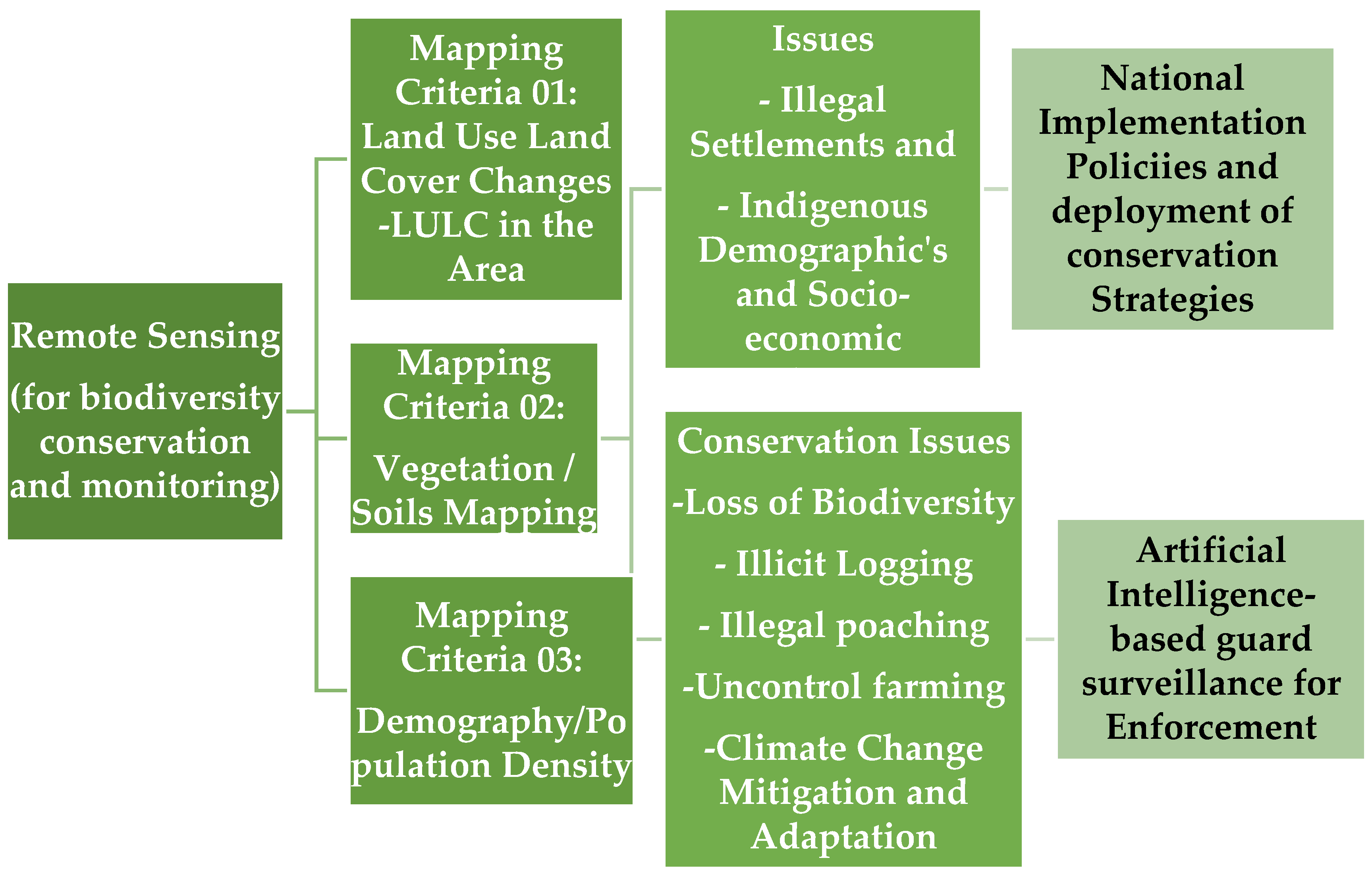
RS, or satellite imagery, is the study of data collecting without direct contact with the Earth. Remote sensing may be used to gather reliable information about Earth at many scales, from the global to the micro [20,21,22]. Additionally, RS saves time and doesn't involve any effort as compared to ground-based evaluations [22]. The potential for synergies between satellite imaging and species-based research has been recognized by practitioners, researchers, and data providers to better understand how RS-based studies may be employed in biodiversity monitoring and its conservation [23]. In this study, emphasis has been placed on intelligent satellite remote-sensing technologies. Three distinct parts of satellite imaging monitoring and studies on these national parks, with an emphasis on the LULC and comparative study of the eighteen (18) significant sites in Nigeria, are satellite communication data, strategies for handling satellite data, and application. Typically, low-resolution, medium-resolution, and high-resolution images may be downloaded from satellite imagery. The amount of detail in these satellite images varies depending on the level of detail grade, and they offer a lot of information about the earth's surface. Academics have developed a variety of techniques to deal with the complexity of the information associated with large datasets. These approaches employ mathematical, uncertain, nonlinear logic, neural networks with artificial intelligence, and statistical methods. A variety of proprietary and open-sourced software that takes algorithmic and data handling into account is included in the third possibility. In this paper, the initial use of satellite remote sensing is explored, along with many arrays of earth-observing satellites and their uses in environmental surveillance. Satellite imagery is another resource that may be added to a GIS. Satellite observation is the study of images and other data obtained by satellites, air balloons, and unmanned aerial vehicles [24]. GIS can also incorporate statistics in the form of data tables or spreadsheets, such as demographic information. Age, earnings, ethnicity, recent purchases, and online browsing patterns are just a few examples of statistics on demographics. Irrespective of the information's source or initial format, GIS technology makes it possible to overlay all of the above-mentioned different types of information on a single map [24,25]. The main index variable that GIS uses to link these scattered data pieces is the location. Entering information into a GIS is referred to as data capture. Most tables and satellite images are examples of data that is already in digital form and is simple to add to the maps [26]. However, photographs must first be digitalized or otherwise converted into a format that can be created by a computer[24,25,27]. The two primary types of GIS file formats are raster and vector. Raster formats are collections of images or squares. Raster formats are useful for storing GIS data that is variable, such as terrain or satellite photography. Nodes, points, and lines are the building blocks of polygons in vector formats. Vector-based formats are appropriate for storing GIS data with clear boundaries, such as educational institutions or roads.
Throughout the study period, abuse, misuse, and neglect have occurred due to specific circumstances in this region of the world [20]. However, due to its size and massive number of national parks, focuses on Nigeria within the context of West Africa, and the findings of this study would be applicable throughout the SSA area in Africa. The employment of artificial intelligence-based guard and security monitoring is required to enhance and implement national policies on biodiversity conservation through the enforcement of every localized strategy by the public and commercial sectors [27,28]. The value of biodiversity to West Africa is well established. Numerous environments, from arid savanna to tropical forests, are home to more than 2,000 species of mammals, birds, and amphibians [29]. The tropical forests of the Upper Guinean countries are the region's main source of biodiversity. Along with 800 bird species and vascular plant species, these lowland forests in West Africa are home to more than a fifth of Africa's animal species. The Upper Guinean forest is renowned for its diversity of primates and has been dubbed one of Africa's most significant fossilized primate preservation zones because of its importance. A tiny population of western lowland gorillas near the Nigeria-Cameroon border and the last surviving dispersed populations of the endangered western chimpanzees are also found in the West African forest habitat. These two great apes of Africa are also found there. Over 7,500 African elephants live in the West African nations, while many of these herds are found outside of the forest ecosystems in northern savannah areas. However, the Upper Guinean forest ecosystem of West Africa is one of the planet's most severely fragmented areas. Logging, mining, hunting, and the increase in human population are severely stressing the woods and endangering species [30]. This remnant forest, which is largely used for lumber production, does not represent an entire environment. Additionally, there is extensive indiscriminate trapping and hunting across the forest zone, and the impact on populations of primates and forest antelopes in particular is growing as harvest rates increase. Similar to how hunting has caused a catastrophic drop in large animals throughout the Sahel and Sahara zones in the region's north, whether it be for sport, trophies, or meat. Carnivore populations, including those of the African lion, are negatively impacted by the decreased prey base in the area [24,25,26,27,28,29,30].
1.1. Protection of National Parks Using Remote Sensing
Protected regions are designed to protect biodiversity and provide a way to monitor the progress of such protection. Other areas that have been recognized as being essential for certain conservation goals are frequently included in protected areas [31]. These areas include Important Bird Areas (IBA), Endemic Bird Areas (EBA), Centers of Plant Diversity (CPD), Indigenous and Community Conserved Areas (ICCA), Alliance for Zero Extinction Sites (AZES), and Key Biodiversity Areas (KBA) [20,31,32]. A network of protected areas can be found inside a larger geographic area known as a terrestrial or marine ecoregion, much as how a single protected area may be located within a protected area [31,32]. Thus, a range of governmental structures and political policies may be used in repositioning the protected areas. The success of protected areas now depends on the effective management of those regions. A protected area can therefore protect a wide range of natural resources. Protected areas are essential for sustaining substantial natural resource reserves, particularly stocks of carbon[32,33,34,35,36]. Many will be designated solely for the preservation of particular species, whether they be flora, fauna, or the interactions between them. As 20% of global carbon emissions are believed to be caused by deforestation, protecting global carbon stocks decreases greenhouse gas emissions and avoids long-term land cover change, which is an effective strategy in the battle against global warming. Protected areas contain 15.2% of the total amount of terrestrial carbon that is stored worldwide [37].
Conservationists are very concerned about land-cover change because of its often negative consequences on biodiversity [20,30,31,32]. These changes must be closely monitored, and the information provided here might greatly enhance a global system for biodiversity monitoring. Monitoring biodiversity is an essential component of conservation since it allows us to pinpoint problems, set priorities, develop solutions, and allocate resources [32,33]. Evaluations of the status of the goals and metrics in national and international conservation-policy instruments, such as the Convention on Biological Diversity, as well as the outcomes of global conservation policy and other policy sectors, are made possible through monitoring [34]. However, due to a lack of information, the cost-effectiveness of conservation initiatives has received little attention, which has led to criticism of them, and the global distribution of terrestrial biodiversity and the distribution of monitoring efforts are glaringly out of sync [35,36,37]. Most species and habitats are not regularly monitored in any systematic way. There is no framework in place to address the issue globally, despite some systematic monitoring of terrestrial biodiversity for conservation being done locally in that are developing. Traditional methods for population or habitat monitoring involve field observations. In far-off or uncertain political contexts, this strategy is costly, time-consuming, and difficult. Although field-based monitoring must continue, a global biodiversity observation system based on changes in land cover identified from data acquired by earth observation may be able to bridge the current reporting shortfall. In recent years, free higher-resolution satellite image data was offered. A handful of organizations on Earth Observation by the U.S. Geological Survey began looking at this potential as a reality since the high cost of acceptable remotely sensed images has been a substantial obstacle to EO-based surveillance systems up until recently [38].
1.2. RS and GIS for Geospatial Analytical Framework
The gathering and analysis of geographical and geographic data are made possible by a theoretical framework known as a Geographic Information System (GIS) [38,39]. GIS applications, also referred to as GIS apps, are computer-based tools that enable users to create interactive queries (user-created searches), store and modify geographic and non-spatial data, analyze spatial information output, and display the outcomes of these operations as maps to visually communicate the results. Geographic information science, or GIScience, is the scientific study of geospatial concepts, tools, and techniques. Geospatial information systems are used in a variety of new developments, methods, strategies, and processes. They have a variety of uses and activities in the sectors of business, engineering, strategy, leadership, logistics and transportation, insurance, and telecommunications. Position-enabled solutions are built on GIS and intelligence-based location applications, which use geographic data analysis and representation. In GIS, the "key index variable" that connects previously disconnected data is location 40]. The position and extent that are found in the Earth's space-time can be recorded using the date and time of the occurrence as well as the x, y, and z coordinates, which stand for longitude (x), latitude (y), and elevation (z). The GIS presents itself as a dependable, flexible technology that may help with the administration of property data [38,39,40,41]. GIS has been used extensively in the management of renewable resources, but less so in the management of land, notably in SSA. This may assist in explaining why GIS software has not yet been embraced by many land registers in Nigeria. It must be embraced and used to maintain land records to execute lucrative and successful urban land governance, which is necessary for equitable growth. The definition and operation of a geographic information system [42]. GIS has been described in several ways by various scholars, with each explanation reflecting the viewpoint and professional focus of the author. There is no accepted definition of GIS as a result. The term "variability among organisms that exist from all sources, especially land, sea, and other water-based environments and the ecological networks in which they are comprised" is used to refer to biological variety, also known as biodiversity [43]. This includes a range of environments both between and within species. Preserving biodiversity is intimately related to worries about global environmental change and globalization, such as changes in land use and land cover, changing temperatures, and environmental sustainability [44]. Humans have transformed ecosystems more swiftly than at any previous point in history as a result of the speedy industrialization that has replaced the forest during the past century. This loss is made worse by the lack of biodiversity knowledge, especially among those who have strong ties to the ecosystem. Conducting inventories to determine the scope, distribution, and dynamics of biodiversity is a worldwide issue. Integrating human land use with nature is essential for modern-day environmental conservation [38,39,40,41,42,43,44,45].
1.3. Monitoring the Trend of National Parks Invasions
According to patterns in population expansion, the earliest parks and reserves in Africa were created when there were environmental restrictions on the human population. A tiny human population resided in a large region that was reliant on a huge amount of resources due to diseases and unfriendly environments (suggesting a low human population density). When the first protected areas were created at the beginning of 1900, around 14 million people were living on the continent of Africa, but as of now, 92.3 million people are living there [46]. Africans did not yet place a high value on material items, there were not many people in the world, and their way of life was still influenced by the environment before the start of the 20th century. Given that resource availability in that circumstance much outnumbered resource usage, there have been no complaints of environmental impact. Making protected zones could have been straightforward at the time given the minimal social and economic costs. In comparison to protected areas located in areas with high human population densities, those located in low human population density regions had greater biodiversity preservation [19,20,21,22,23,24,46]. The Aichi Objectives "Living in Harmony with Nature" and the United Nations Decade of Biodiversity's Strategic Plan for Biodiversity were both taken into consideration in this study. Biodiversity supports the provision of ecosystem services required for human well-being and the health of the environment. It promotes local livelihoods and economic growth, which is essential for accomplishing the goals, in addition to guaranteeing food security, human health, and access to clean water and air. Even though biodiversity is incredibly essential, it nevertheless continues to decrease. The Parties to the Convention on Biological Diversity approved the Strategic Plan for Biodiversity 2011-2020 in Nagoya, Japan, in 2010 to promote widespread action in favor of biodiversity over the next ten years by all states and stakeholders. In reaction to the circumstance, this was done. In recognition of the urgent need for action, the UN General Assembly has also declared 2011–2020 the United Nations Decade on Diversity. The plan for the future for Biodiversity 2011-2020 is a 10-year action plan for all countries and parties to maintain habitat and boost its benefits for people by integrating it with the landscape planning and management methods included in the goals and objectives of the various strategies [38,40,41,42,43,44].
1.4. National Implementation Strategies
In general, it has been noted that environmental changes are both a cause of and a result of land degradation, which results in the loss of significant land resources [47]. This study has shown that an equilibrium must be achieved in the uses of the land to lessen the significant ecological consequences of altering land use or land cover [28,29]. If the current rate of encroachment is maintained everywhere, the nearby towns of the chosen sites will be linked to the developed area of the growing communities, as will become clear from the efficient geospatial monitoring using the UAV and subsequent assessment with the GIS software. Forests, savannas, farmland, arid regions, and river floodplains have all been swallowed up by rapid expansion. Forests and wetlands have been degraded. Between 1984 and 2022, due to urbanization and physical development, about 60% of the riparian forests in the forest reserves in Nigeria and the rest of sub-Saharan Africa were destroyed. This altered natural habitat and severe loss of biodiversity resulted in the extinction of some wild animals (see Table 1, Table 2 and Table 3).
The significance of this study focuses on the most relevant national parks in Nigeria (highlights of West Africa’s parks), this study tries to determine the degree of encroachment and degradation by adopting remote sensing technology, and sustainable biodiversity conservation approaches. The study's questions highlight the necessity of modern digital picture processing, inventory, and evaluation. The research emphasizes the requirement for RS in information collecting, biodiversity conservation challenges, ecoclimatic spatial linkages, and understanding the influence of human forces encroaching on the landscape. Similar eco-climatic conditions, picturesque landscapes, and the disappearance of distinctive protected areas may be seen throughout Sub-Saharan Africa (SSA).
2. Methods: The Study Protocol
The evaluation of the ongoing land-use changes that have taken place over the previous 35 years (1985-2022) employed remotely sensed imageries. The enormous changes, encroachment, and deterioration in the region around these national parks are seen in the Landsat imageries collected in 1985 and 2022. The 18 sites chosen are Kainji Lake National Park, Kamuku National Park, Gashaka-Gumti National Park, Chad Basin National Park, Old Oyo National Park, Yankari National Park, Allawa National Park, Apoi National Park, Edumenum National Park, Falgore National Park, Hadeja Wetland National Park, Kampe National Park, Kogo National Park, Marhai National Park, Oba Hills National Park, and Pandam National Park. The study area is defined by a circular boundary with a 2 km radius, and it has an average total length of 12,85 km and a total area of 12 km2 for each sample frame (see Table 1 for the names of the national parks, land area (Km2), Landsat images (obtained from Google Earth Pro), and geographic coordinates for the state (host province). The protected region in Nigeria provides some benefits and advantages, just as wetland ecosystems all over the world. Areas that have been cut through may contain mangroves, vegetation, dry woodlands, salt and freshwater bogs, and more. This national park is home to a wide variety of species and stretches from the ocean to tropical reefs. Due to the uniqueness of the sceneries, Nigeria's parks are the most popular tourist sites. These parks are vital for functioning as a carbon sink to lower the global temperature through evaporative cooling and carbon sequestration.
These acquisition dates and periods were selected taking into account the seasonal water management and vegetation phenology of the targeted wetland. The images were radiometrically adjusted and geometrically registered to provide an appropriate map projection. The picture was categorized into seven different groups: high forest, disturbed or degraded forest, disturbed or degraded tropical or subtropical land covers, settled farming, settled water bodies, established human settlements, and mountainous landscapes. Additionally, supervised maximum likelihood techniques were used to classify all satellite images. This clear raster was checked for changes in each land feature category by estimating them in a geographic information system with the ArcGIS 10.2.1 tool. The study also evaluated Land Cover and Land Use Classes (high forest, disturbed/degraded forest, derived savanna, montane forest, shrub-land/farmland complex, water body, settlement, and empty terrain; see Table 1 below), Possible Observation Dimensions (National, Regional, Global), along with Instrumentation ( like Landsat TM, ETM+, and Corona). The sampling technique utilized in this study as opposed to the entire survey was the key element that reduced the accuracy of the data. Clear imagery was obtained for free from Google Earth Pro. The study looked at and assessed changes in land use and land cover over 35 years using a combination of fieldwork, aerial surveys (UAV), and satellite images.
Using remotely sensed imagery, the savanna woodland in the study parks was located, and the following indigenous trees were discovered to prevail there: Burkea africana, Terminalia avicennioides, Detarium microcarpum, Isoberlinia tomentosa, Diospyros mespiliformis, Polysphaeria orbuscula, Terminalia macroptera, Isoberlinia doka, and Afzelia are some examples of related plant species. The Hakea francisiana, Acacia argyrophylla, Abies, Abelia, Dovyalis abyssinica, Abarema, Abies balsamea, Acacia adunca, Lagarostrobos franklinii, Adenostoma, Adenaria floribunda, Salix fragilis, and Adenostoma fasciculatum species are all included in this list of native trees. All of the selected national parks had human impact, although some more so than the other 18 parks as a result of misuse in agriculture and exploration, which led to deforestation and deterioration apparent in the Landsat imageries below, captured between 1985 and 2022. This study documented the extent of the degradation and many other factors from which future projections and evaluations could be made as regards biodiversity conservation.
2.1. Study Area: Nigeria (West Africa)
Nigeria's diverse natural resources, from the Sahelian savannas in the north to the tropical coastal plains in the south, are significantly strained as a result of the country's fast population growth and economic growth. The third-longest river in Africa, the Niger, flows 4,000 kilometers from the Guinean Highlands to Nigeria's Gulf of Guinea, which is located on the Atlantic Ocean. It drains into a network of canals at that location, forming a significant coastal delta with extensive mangrove and swamp forests. The Niger Delta is a region with a high diversity of plant and animal species, covering over 70,000 sq km. Nigeria's economy, the second largest in Africa in terms of nominal gross domestic product (GDP), has been supported by the continent's second-largest oil and natural gas reserves.
Figure 2.
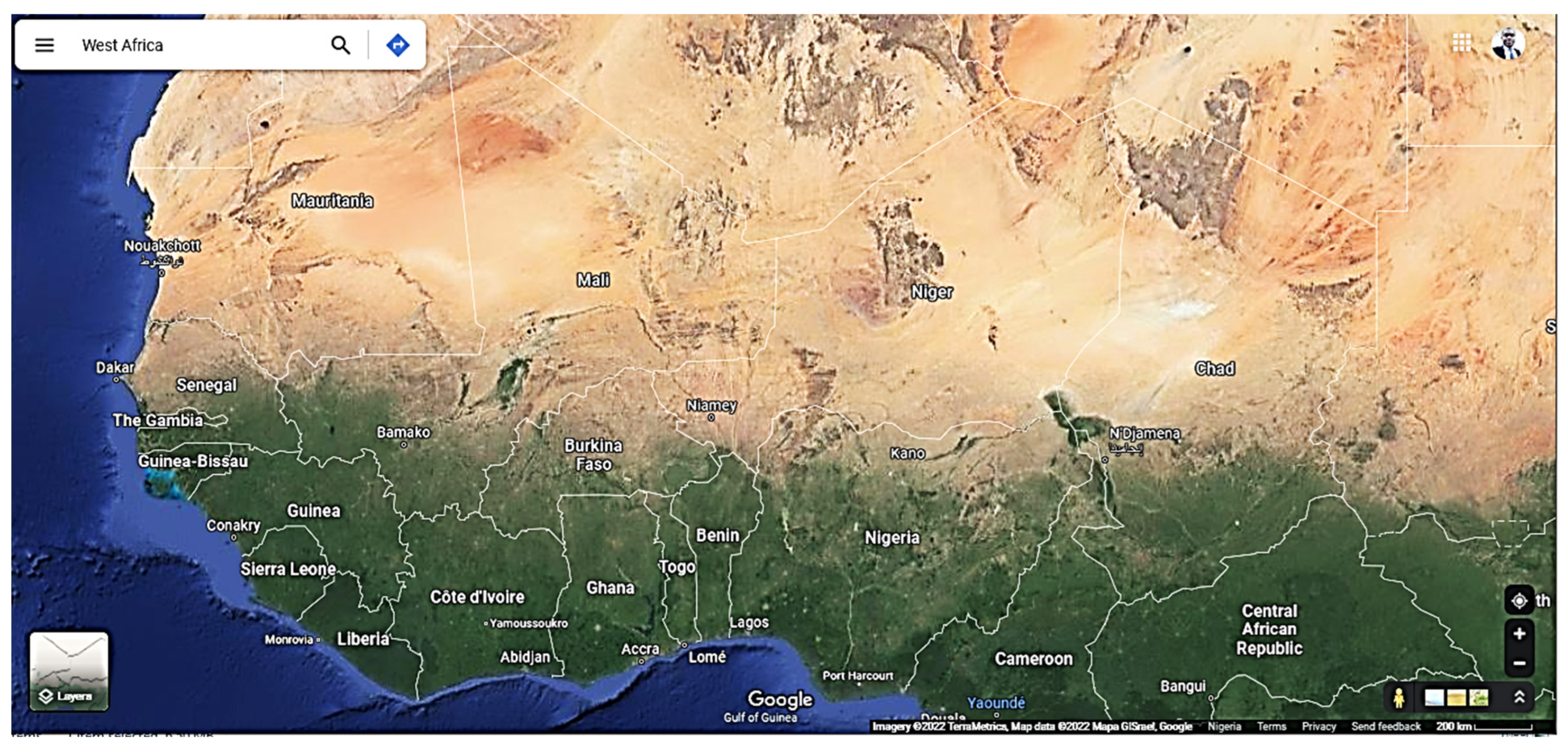
Map showing the vegetation patterns common to the Countries in West Africa.
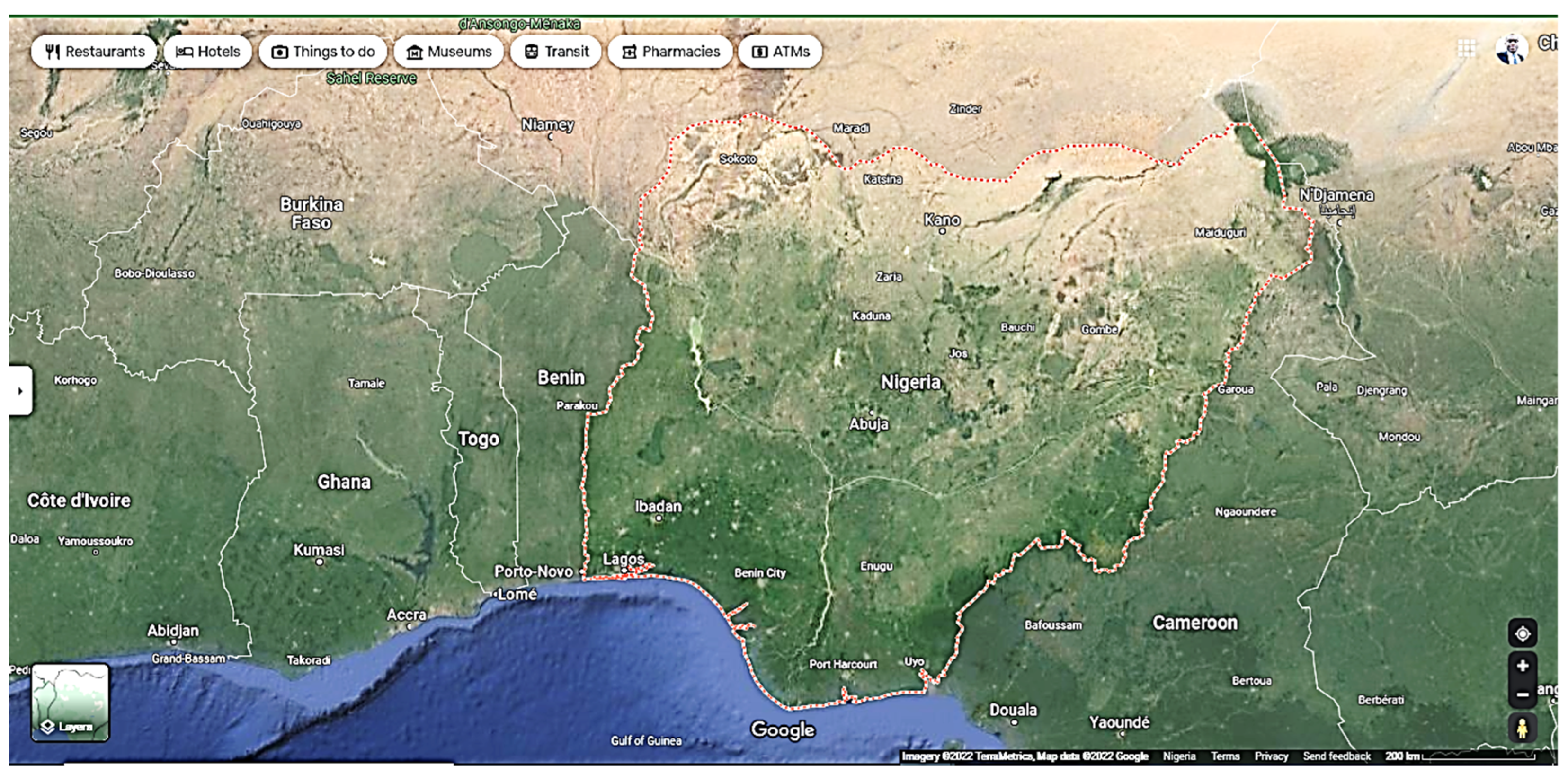
Due to its cultural variety and challenging environmental conditions, Nigeria is a microcosm of all the possibilities and difficulties in Africa. The majority of Nigeria's heartland is made up of the basins of the Niger and Benue rivers, which merge to form a "y-shaped" confluence. Nigeria's agriculture is given a lifeline in the semi-arid north and center of the country by the Niger River and its tributaries, which supply water for a variety of food and cash crops. The mangrove and swamp woods that predominately cover the lowlands that surround the coast in the southwest and southeast combine into badly degraded forest inland. Southwest of the Niger Basin, there is a harsh topography made up of mountains with western influences. The Jos Plateau Nigeria's largest region over 1,000 meters in elevation arises dramatically from the riverine plains. The northern part of the country, which is characterized by slightly lower heights, flat terrain, and sandy substrates, is dominated by farming.
Figure 3.
Map Showing the terrain of Nigeria within the WA Sub-region.
There are several ecoregions in the six geopolitical zones, and each of them has unique features. The fact that they are all different natural ecosystems that are essential to the existence of park animals and guests is another element that unites them all.
A total of 24,429 km2 is covered by the eighteen selected study sites, which comprise a wide variety of habitats and a significant number of viewable and diverse landscapes. The selected national parks were declared as conservation sites by the Federal Government of Nigeria and included among the permitted national parks. This imposes a fundamental duty on the park to preserve and protect the wetland values on a local and global level. The Google Earth Pro database was used to freely obtain Landsat pictures for the years 1985, 2011, 2013, 2017, 2020, and 2023 (see Table 2 and Table 3). The terrain and main ecological regions of Nigeria are depicted in the maps below.
Figure 4.
(a-right) Map showing the Eco-regions of Nigeria. (b-left) Nigeria Ecological Belts and Geopolitical Zones.
Figure 4.
(a-right) Map showing the Eco-regions of Nigeria. (b-left) Nigeria Ecological Belts and Geopolitical Zones.
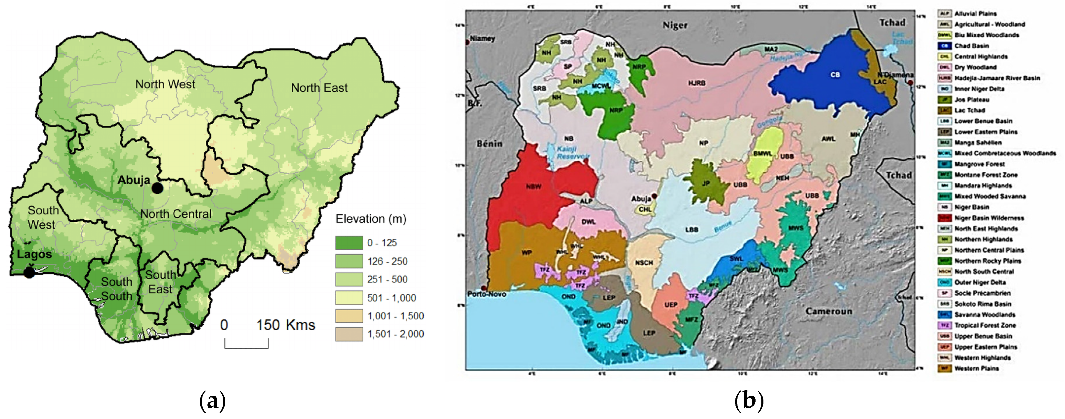
The Sahel, Sudan, Guinea, Rainforest, Fresh Water Swamp, and Mangrove are the six sub-regional ecoregions of Nigeria. The map of protected areas was created using data from the World Database on Protected Areas (WDPA) [48]. Given the magnitude of demand for natural resources, the rigorous approach to management now used by the majority of States and Local authorities is insufficient. In Nigeria, the forestry and biodiversity extension services have collapsed, putting the management of natural resources in an uncontrolled loop. However, there are only a few cases where locals have taken the initiative to organize ecotourism, share royalties and profits, and conserve and restore forests [48]. Examples of these cases include various states across the six geopolitical regions in Nigeria [see Figure 5 below].
The Convention on Biological Diversity (CBD) is a global agreement that was formed by the UN [48,49]. On a global basis, it aims to preserve biological diversity. Nigeria joined CBD as a party during the Rio de Janeiro Earth Summit in 1992. The three main objectives of the CBD are to safeguard an equal distribution of the benefits from the use of genetic resources and to maintain biodiversity [48]. International collaboration and information exchange are highly valued by the Framework Convention. The CBD has created the Clearing-House Mechanism (CHM), sometimes referred to as the Clearing House Mechanism of Nigeria - Home (chm-cbd.com.ng, 2018), as a global network of partnerships to support these activities.
2.2. Digital Image Processing, Inventory, and Assessment
The study was dependent on the use of computer-assisted Landsat image interpretation, and a field survey was carried out throughout the study region using a GPS while taking into account the following criteria in the checklist (see Table 1). The research was conducted to produce signatures, establish training locations, and collect accurate location point data for each LULC class included in the classification system. To get the required information, the satellite picture data underwent rigorous processing and analysis. Before the interpretation phase, a first narrative had to be created. A situation might be seen in the 1985 Landsat TM imagery (not well visible for assessment), which was taken 35 years before the most current Landsat ETM imagery. The interpretation was confirmed by nearby historical facts, even though the images could not be matched to the actual situation [48]. However, the most recent and current satellite image from 2023 was immediately contrasted with actualities on the ground. The post-interpretation process included the development of LULC maps and the identification of their alterations. In the current study, the categorization assessment was employed as a method of change detection [50,51,52,53,54,55,56,57,58,59,60,61]. After that, the overlay images of land use and land cover over the past 35 years were put into an adjustment matrix. Using images from the same period helped to lessen the effect of seasonal changes on the result. Applications for geographic information systems are used to identify information from data sheets, the internet, visual evidence, and geographic data. Topographical information, which is now available in the form of maps, may include information about the locations of things like rivers, hills, motorways, and canals. Using photographic interpretation, the features seen in the photos taken above are studied and assessed to produce survey findings and data for mapping as shown in Table 1 below.
The seven criteria included in the checklist above—rainforest, degraded forest, tropical or subtropical land covers, agricultural settlement, waterbody human habitation, and mountainous landscapes—were taken from published works and are thus easily adaptable to the analysis of different landscapes [55,60,61,62]. The word "rainforest" describes a geographical area that is heavily covered in tall trees and other kinds of flora. The degraded woodland is an area that is covered with secondary forests. an area having a tropical or subtropical climate that is primarily made up of grassland, maybe with a few stray trees. Trees thrive in steep or hilly terrain; and mountainous environments. A shrubland is an area of land that is predominantly covered in shrubby vegetation and/or crops. A dam or river would be an examples of a waterbody. In addition to an incredible network of wetlands, an abundance of fish and other animals, considerable forestry resources, and a unique and varied national history, Africa is home to a wide range of significant and plentiful biological resources. The need to maintain the nation's population's economic and subsistence activities, which depend on the use of natural resources, is what motivates the conservation of these resources. Nigeria is a floristically diverse nation with 22,000 different types of vertebrate and invertebrate creatures and 7,895 different plant species in 338 different families. These species include over 20,000 insects, 1,000 birds, 1,000 fish, 274 mammals, and 123 reptiles over 5 percent of this diverse biological diversity is either endangered or vulnerable in the past years and if it is not controlled or managed effectively it is going to worsen in the coming years [63]. Table 2 shown in the remarks column reveals the present state of the National Parks as it relates to each of the host states (provinces).
3. Results and Findings
Adequate assessment of the various study sites (eighteen) and the analysis of their analysis of inherent and peculiar bioclimatic characteristics which are common to all the parks as they share similar bioclimatic conditions and within the same ecoregion. This study cut down on time and cost of interpretation. The authors adopted a sampling scheme, consisting of a random sample of 2 Km2 frames stratified by ecoregion with similar biophysical and human management conditions.
For Nigerian universities and other academic institutions, they also serve as outdoor research labs. The National Parks are Nigeria's ecological gem and, when properly developed, might contribute significantly to the country's economy, much like East and Southern Africa have in the past. One of the considerations made by the government is the relationship between protected places such as national parks and national security. For the sake of national security, protected areas are crucial. Regrettably, the bulk of State-owned Forest Reserves have recently become violent crime hotspots. As a result, the creation of these protected areas will provide the necessary tools to prevent criminal organizations from residing in or looking for hiding places within these Regions, thereby bolstering the current effort to combat insurgency as well as other organized crimes like kidnapping, cattle rustling, and banditry, among others.
Figure 6.
Chart showing the percentage of land cover in the National Parks.
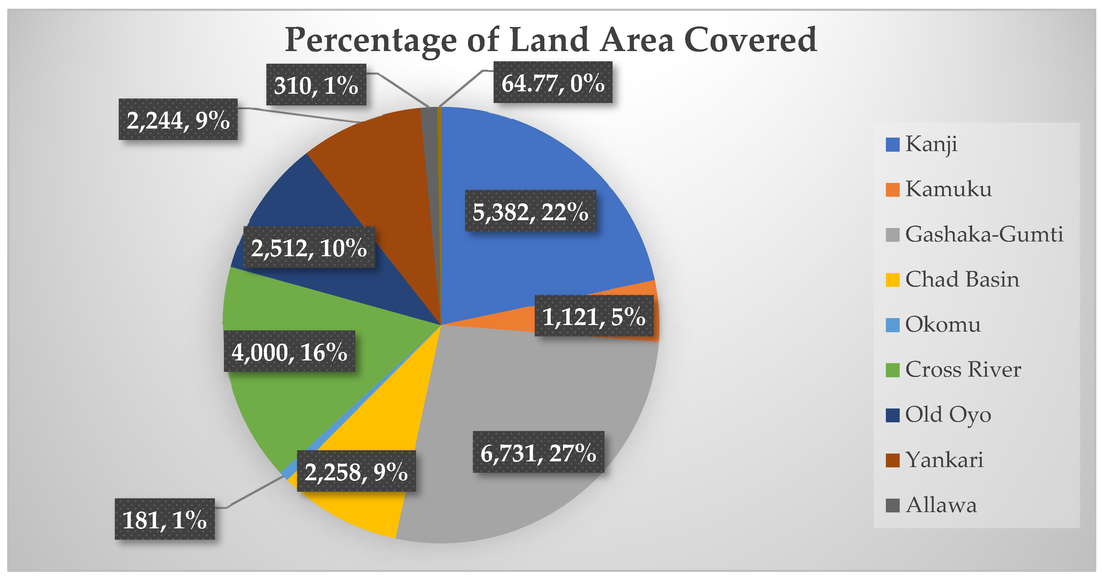
The results show that the dominant land use and land cover in the study site were disturbed/degraded forests. On the available land resources, it has been noted that growing populations and commercial activities are putting pressure on them. The national wildlife reserves and national parks that have been mentioned above are the national parks in Nigeria that are now required due to the global consequences of climate change [40,41,42,43,44,45,46,47,63].
Figure 7.
Chart showing the land area distribution of the first ten designated National Parks.
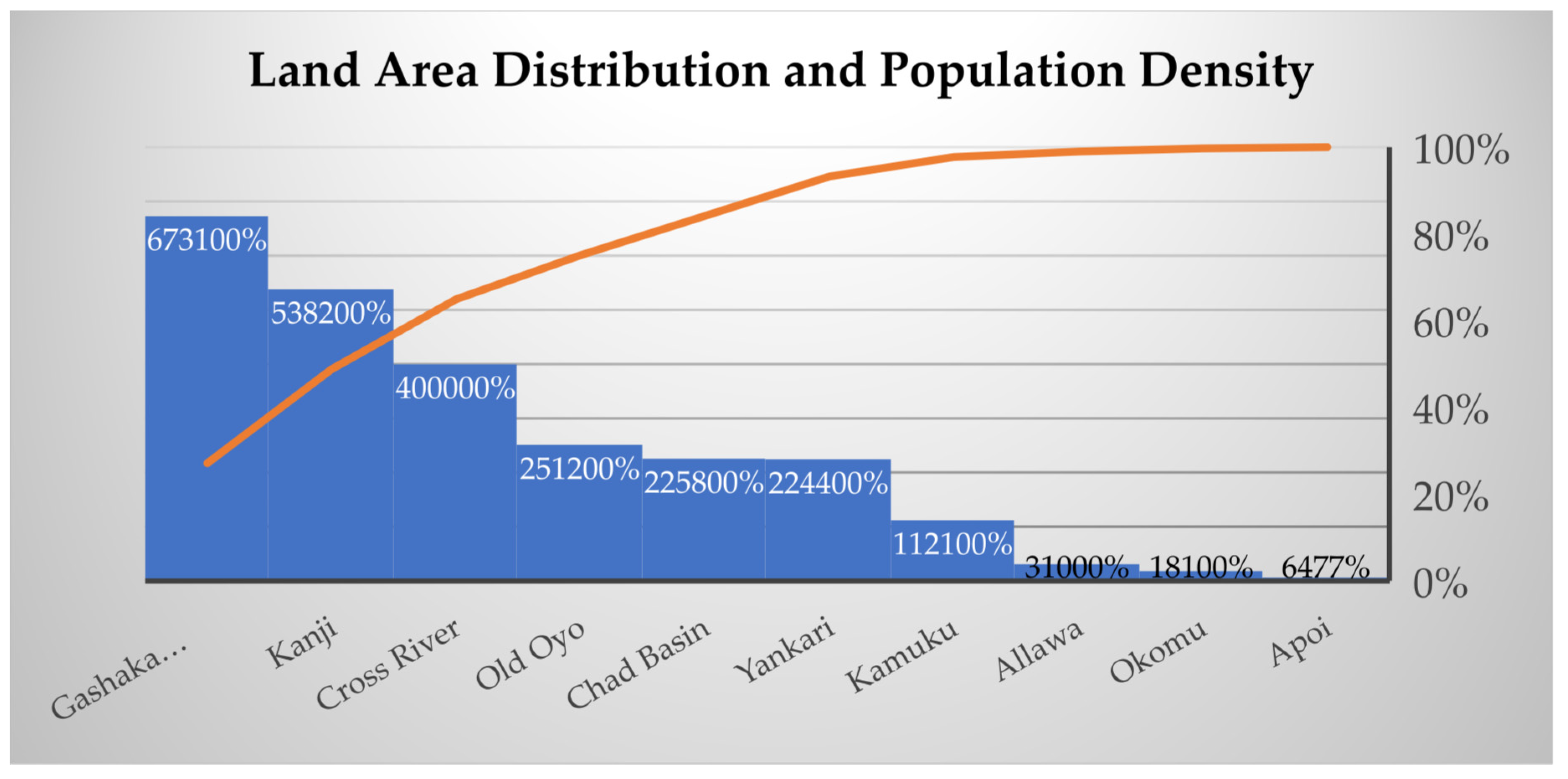
To store carbon and mitigate the effects of climate change and other ecological issues, the United Nations has set a goal of covering around 25% of the territory of its member countries with permanent vegetation. You might find it interesting to know that over 10% of Nigeria's entire surface is now covered in vegetation, which is egregiously inadequate in comparison to global best practices. Unquestionably, the development of these Parks will boost job opportunities, alleviate rural poverty, and ultimately boost the nation's economic profile, particularly given that Nigeria is seeking to diversify its economy. Eighteen (18) National Parks span every one of the country's natural zones, except for the ocean habitat.
This could be seen in a close look at the Gashaka-Gumti National Park (Figure 8) and the impacts though the rainforest, degraded forest, tropical or subtropical land covers, farmland settlement, waterbody human, settlement, and mountainous landscapes are not grossly affected by anthropogenic influences and natural environmental factors. Figure 9 shows a graphical outlook of the LULC map and Figure 10 shows the soil type and elevation map. The detailed impact of Gashaka-Gumti National Park can be seen in Table 3 where images were captured on the following dates 12//31/1985, 02/17/2011, 06/16/2013, 04/29/2017, 12/19/2020 and 02/06/2023 respectively.
In the above figure, the blue-colour area shows the lowest point and possible floodplains, and the red-colour area shows the presence and continuous influx of human activities. The green-colour area is the existing green zone that requires conservation and restoration as the case may be. Figure 10 below reveals the soil types and the purple-colour graphical outlook details the highest points where few farming and lumbering activities are being done, The black-colour patches are the built-up areas that have lost any kind of vegetation and finally, the green-colour areas are the lowest areas predominantly occupied with biodiversity worthy of been preserved.
Looking at the percentage of increase of Nigeria's national territory with some form of conservation area status, and the percentage of increase of conservation areas assessed to be sustainably and effectively managed. These frames provide a useful framework for effective research, inventory, and management of natural resources. A total of 12.6 square kilometers were chosen, from the total land area in each sample frame of the selected park. Each sample frame was manually interpreted using the parameters identified above. An RS approach was preferred for working with digital vectors and raster imageries of the areas. The RS tool was used to identify, interpret, and graphically represent the elements of tone, hue, texture, shape, size, pattern, shadow, and geographic context. The indicated 2-kilometer square radius sites were randomly chosen within the existing ecoregions of Nigeria which is similar to the other West African states. Further studies will be conducted on these national parks with a focus on the LULC and comparative analysis of the three key variables in the study area; vegetation, soil analysis, and demography/population density analysis. It was, however, difficult to access some data on the registered national parks, most of the information was sources for randomly.
The country wants to make sure that all ecological system types, which have been adjusted for this study with the ecological assessment shift qualitative review, are included in a mix of at least 10% of Nigeria's national territory that is ethically managed in protected areas at various levels of authority. The information below was taken from a report by About Nigeria and adapted to the study's national goals. Nigeria seems to be on pace to accomplish its CBD objectives. In light of the fact that there are presently and will continue to be more national parks than ever before, the evaluation of the assessment demonstrates progress toward reaching the specified goal [62,63]. This study assesses the objective using a quantitative indicator that can be independently confirmed. Measurable parameters that may be independently confirmed are used to evaluate the data gathered through monitoring the RS-based monitoring system and the monitoring procedure [64]. New national forests are being declared to increase the percentage of Nigeria's national territory that is effectively and sustainably managed in protected areas with the portrayal of all habitat types [65].
4. Discussion
Environmental changes that result in the loss of irreplaceable land resources are a cause and an impact of land degradation most especially in SSA. This study has shown that an equilibrium must be achieved in the uses of the land to lessen the significant ecological consequences of altering land use or land cover thereby losing the rich and scenic natural landscapes.
4.1. RS for Information Gathering
The peculiarities of the swamps in the research region may be seen thanks to data gathered using multidimensional, multiyear remote sensing. This analysis demonstrates that the increase in plant cover coincided with the wetland's sharp deterioration. The nearby wetland has declined as a result of the recent plant invasion in the region. Places that have been designated as national parks are regulated to protect the environment and wildlife. The parks contain a range of rare and endangered plant and animal species, including elephants, gorillas, giraffes, monkeys, golden cats, hippopotamuses, crocodiles, etc. The responsibilities of the Nigerian government's Parks and Wildlife Service include public education about protecting and preserving the biodiversity of plants and animals, searching the parks to prevent poachers from engaging in illegal activities, stopping those activities, apprehending offenders, and prosecuting them. One benefit of national parks is the existence of water catchment areas and other life-supporting systems. National parks have great promise for the development of inquiry, specifically in the areas of food production, healthcare, and bioengineering.
4.2. RS for Conservation Issues
Numerous interactions between people negatively affect the national parks and protected areas, despite the comparatively low population density in the area around the park. These include unrestrained burning, illegal grazing, and deforestation. There are relatively few wild animals left on the earth because of illegal poaching. Many of these limited regions have seen a sharp decline in their fisheries as a result of the vast number of artisanal and subsistence fisherfolk accessing the lake. To increase fish supply, a period of closure and restricted fishing rights have been suggested. demonstrating how various cutting-edge remote sensing imageries may be used to gather the relevant metrics and drivers required for diversity evaluations. Nevertheless, certain protected areas are either not included or lack geographic information in the WDPA database structure, making it insufficient. The present study will update the map while finding a few particular conservation sites in Nigeria that have not yet been recognized by UNESCO, especially in the southwest of the nation where the natural environment is rich in the protection of wildlife.
4.3. RS for Spatial Relationships
Using RS-GIS technology, networks, and spatial relationships may be shown. Spatial connections, such as those created by streams and agricultural fields, can be used to display topography. They could also display patterns of land use, such as the locations of parks and housing complexes. Highways, rivers, and grids of public utilities are typically displayed in a GIS as linear networks, sometimes referred to as geometric networks. A line on a map could represent a highway or road. However, using GIS layers, the road may represent the boundary of a school district, a public park, or other demographic or land-use zones. Using a variety of data-collection techniques, the linear network of a river may be represented on a GIS to illustrate the stream flow of several tributaries. Remote sensing combined with Geographic Information Systems (RS-GIS) must align the data from all the various maps and sources so that they all fit together on the same scale. A scale connects the distance depicted on a map to the actual distance on Earth. Some peasant farmers and migratory pastoralists have seen their main source of dry season pasture diminish, and some of these peasant farmers, migratory ranchers, and ecological and forestry conservation agencies are facing increasing land use pressure around the parks. These conflicts have been caused by land consolidations and mergers by big property owners The safeguarding of wildlife and biodiversity throughout game reserves in a region that at the moment experiencing the greatest growth in population in Nigeria, will continue to be endangered in the absence of a comprehensive policy that controls access by various user groups to land resources, land ownership in addition to grazing and cropland abuses.
4.4. The Impact of Landscape Encroachment by Human Factors
Even though the proportionate frequency of the total area covered by population in the last year of the analysis was lower than throughout the whole research region, settlement expansions were the main cause of the change. Between 1985 and 2023 (in the course of and shortly after the dry season), the settlement's relative net increase was around 50%; nevertheless, over the subsequent 35 years, it increased by over one hundred percent, or more than twice as much. The community expanded far more recently than it did during the drought and soon after it, as well as throughout the post-drought period. The apparent evidence of land degradation and encroachment was seen between the same periods as the relative net rise in settlements in the selected areas. Figure 9 and Figure 10 compare the relative sizes of the parks, which are connected to the net changes in the various LULC classes. Southern West Africa's central belt and coastal regions were the main locations where this alteration was seen. The growth of settlements at the expense of other vegetation, cropland, and forestland was one of the major changes overall; in other words, settlement expansion is one of the primary factors in the loss of forestland, other vegetation, and farmland in Sub-Saharan Africa.
4.5. Human Activities Threatening Biodiversity
The Okomu Forest Reserve was initially established by the British colonial government in 1912. Its initial area was 777 square kilometers, and in 1935, 411 square kilometers were extended to the north and east. Since the reserve was originally meant to be kept as a supply of timber, it has been used for its numerous stands of mahogany. Over the past six to ten decades, rotational farming and illegal hunting have been practiced in the reserve. In this method of managing forests, a portion of the forest is handed to local farmers who would clear it, farm it, and then reforest it with useful tree species. Over time, the continuous forest that surrounded all eighteen parks became overgrown. The region is encroaching on areas and a network of roads, as well as agriculture. The sanctuary has successfully fought poaching while protecting a variety of vulnerable species, including red-capped mangabeys, white-throated monkeys, chimpanzees, leopards, and African forest elephants. The aesthetic impacts of rapid plantation development may be seen in the reserve's northern half, which is dominated by enormous rubber and oil palm plantations, while farmland has taken over the reserve's southern half. Restricted logging and hunting, reforestation, livestock husbandry, and agricultural practices compatible with forest preservation have all been introduced to provide locals with options for sustainable livelihoods. The classification of Okomu as a national park has not alleviated and fully mitigated the effects of continuous degradation both inside and outside the reserve. While some have praised multi-purpose forest management, others have criticized it for neglecting to give conservation measures priority and for increasing the risk of environmental deterioration in Okomu by including a development component.
4.6. Conservation Significance
All large species of animals have extremely low numbers in the study region due to the intense hunting that occurs there. The majority of hunting is done with firearms and wire snares to supply the bushmeat trade as well as the killing of jungle elephants for their tusks. Additionally, grassland fires are steadily burning and weakening montane forests. The three enclave towns within the park have grown into hotspots for poaching and hunting, and the rising agriculture within these same village enclaves is progressively degrading the park from within and splitting it in two. Illegal logging is getting worse, especially for mahogany and all kinds of ebony trees. Huge villages are regularly built within the national forest to gather shrub mangos that resemble NTFPS in a variety of characteristics, but the camps also attract hunters. tracking of endangered and diverse biological species. It is essential to encourage transboundary conservation with the adjacent National Park to accomplish environmentally friendly preservation with neighboring countries like Cameroon, Chad, Niger, and Benin Republics. By coordinating the preservation of two or more contiguous regions that are split by national borders, transboundary management promotes data and information sharing and improves the efficacy of restoration.
5. Conclusions
The development of environmental initiatives, such as staff training, preservation education, and government-sponsored research and tracking, as well as better support and guard monitoring based on artificial intelligence. Hunting decreased as a result. Cybertrackers have contributed to a decrease in illicit activity including trafficking in forest areas. boosting local residents' awareness of environmental issues. Diverse exploration opportunities are promoted to alleviate the pressure on remaining woods and endangered species. On the need to preserve ecological harmony and animal habitats, the community and stalkers are being educated. In the context of the West African region's classification success rate evaluation of significant data retrieval using geospatial imageries, correctness in the comparison between an accurate standard expected and a classified image of unknown features is demonstrated. According to the findings provided here, plant cover surged over the same period as marsh and aquatic ecosystems saw sharp losses. To better understand swamp interactions, it is necessary to monitor landscapes, human-caused occurrences like farming and human invasion, as well as additional natural phenomena like weather variables (rainfall, evapotranspiration, temperature, and relative humidity), as well as satellite imagery. The spread of farming was observed across each ecological region, from the wooded border of southern Nigeria, where roots and tree crops predominate, to the rainforest-savanna transitions in the middle of the country, where strong root-based crops are predominant, to the wheat-producing strap of the drought-prone north of the region.
The Niger and Benue watersheds, which have been promoted as the world's future breadbasket and ideal growing agricultural zones since the 1900s, have seen the most farming expansion into the woods, which has sharpened the borders of the current conservation areas. However, not all protected savanna areas have managed the quick rise of agriculture. Although certain changes in the smaller land cover categories also stand out as substantial, the biggest change in land cover, as a percentage of area, was from savanna to agricultural. Significant urbanization was visible in settlements, flooded fields, plantations, and open mining. Under the pressure of a rapidly growing population and economic circumstances, grassland and woodland vegetation types were all declining, with loss rates climbing to above 10% throughout the evaluation period of the current year. Similar to many other SSA countries, Nigeria views biodiversity largely as a shared resource and national asset. As a result, it is significantly impacted by the tragedy of the common concept, which confines exploitation to the domain of the fittest. It has been discovered that the majority of domestic, commercial, and industrial activities in the country significantly harm the preservation of natural resources. Ecology is a complex subject, and controlling how it is used is challenging. The National Park Declaration Order 2022 was established following Section 18 of the National Park Service Act of 2004. The protected area proclamation sought to establish national park rules based on suitable environmental impact assessments and feasibility studies in certain forests and wildlife refuges throughout many locations. The establishment would tackle the rapidly deteriorating and vanishing Nigerian woodlands, as well as attain and build a sufficient infrastructure to draw tourists while meeting the most recent international standards and facilities, which will help preserve and protect the country's natural and wildlife heritage. To stop the ongoing and severe destruction of the rich natural landscapes, conservation initiatives must be passed, implemented, and deployed nationally. This study however concluded that there is an immediate response to the biodiversity neglect, destruction, and abuse through national implementation policies and deployment of conservation strategies and RS-GIS artificial intelligence-based guard surveillance for enforcement in all the national parks and protected zones.
Author Contributions
A. A. J. prepared the introduction, literature review, conceptualization, methodology, and writing of the manuscript. A. A. J. analyzed the collected data, prepared the maps, and analyzed all geospatial information. T. X. and Y. R. reviewed and revised the manuscript to this present form. T. X., Y. R., and A. A. J. have read and agreed to the submitted version of the manuscript.
Funding
This research was funded by Humanities and Social Science Fund of Ministry of Education (Grant No. 22YJA760075), National Natural Science Foundation of China (Grant No. 31270746), Graduate Education Management Project of Agricultural and Forestry Working Committee of Chinese Academic Degree and Graduate Education Association (Grant No. 2019-NLZX-ZD15), Case Base Construction Project of Professional Degree Postgraduate Courses of Nanjing Forestry University (Grant No.2018AL07) and Higher Education Research Project of Nanjing Forestry University (Grant No. 2018B22).
Acknowledgments
The authors express sincere appreciation to the editorial team and reviewers for reviewing this manuscript.
Conflicts of Interest
The authors declare no conflict of interest.
References
- Gabriele, M.; Brumana, R.; Previtali, M.; Cazzani, A. A combined GIS and remote sensing approach for monitoring climate change-related land degradation to support landscape preservation and planning tools: the Basilicata case study. Appl. Geomatics 2022, 1–36. [Google Scholar] [CrossRef]
- Guimarães, N.; Pádua, L.; Marques, P.; Silva, N.; Peres, E.; Sousa, J.J. Forestry Remote Sensing from Unmanned Aerial Vehicles: A Review Focusing on the Data, Processing and Potentialities. Remote. Sens. 2020, 12, 1046. [Google Scholar] [CrossRef]
- Dainelli, R.; Toscano, P.; Di Gennaro, S.; Matese, A. Recent Advances in Unmanned Aerial Vehicles Forest Remote Sensing—A Systematic Review. Part II: Research Applications. Forests 2021, 12, 397. [Google Scholar] [CrossRef]
- Khan, A.; Gupta, S.; Gupta, S.K. Multi-hazard disaster studies: Monitoring, detection, recovery, and management, based on emerging technologies and optimal techniques. Int. J. Disaster Risk Reduct. 2020, 47, 101642. [Google Scholar] [CrossRef]
- Özdeş, M.; Southworth, J. Arazi Değişim Bilimi: Sahra Altı Afrika’daki savan ekosistemlerinde korunan alanları uzaktan algılama ile gözlemlemenin zorluklarını anlamak. 2023; 76. [Google Scholar] [CrossRef]
- Abdulrahamn, S. Agricultural Development Policies, Programs and Food Security in Nigeria (1985-2010). International Journal of Economics and Empirical Research (IJEER). 2014;2(12):488-95. https://ideas.repec.org/a/ijr/journl/v2y2014i12p488-485.html. (accessed on 1 September 2023).
- Igwe UA, Nwadike CU. Agricultural Policies in Nigeria: A Focus on the Administration of Olusegun Obasanjo, 1999-2007. Interdisciplinary Journal Of African & Asian Studies (IJAAS). 2021 May 9;7(1). https://nigerianjournalsonline.com/index.php/ijaas/article/view/1578. (accessed on 1 September 2023).
- Abubakar A, Gambo J, Umar S. An Overview of the Effects of Some Agricultural Policies in Nigeria-1960-2020. Nigeria Agricultural Journal. 2021 Dec 31;52(3):151-62. https://www.ajol.info/index.php/naj/article/view/223424. (accessed on 1 September 2023).
- Awa D., O. , Rufus A. Agricultural Policy and Food Security in Nigeria’. International Journal of Novel Research in Interdisciplinary Studies. 2017;4(1):27-33. https://www.noveltyjournals.com/upload/paper/AGRICULTURAL%20POLICY%20AND%20FOOD%20SECURITY%20IN%20NIGERIA-914.pdf. (accessed on 1 September 2023).
- Nwozor, A.; Olanrewaju, J.S. The ECOWAS agricultural policy and the quest for food security: assessing Nigeria’s implementation strategies. Dev. Stud. Res. 2020, 7, 59–71. [Google Scholar] [CrossRef]
- Abang PO, Ayamba AI. Agricultural Development Programmes in Nigeria’s Fourth Republic: Changing the Narrative of Food Insecurity in Nigeria. Journal of Good Governance and Sustainable Development in Africa. 2021 Jul 17;6(3):64-74. http://journals.rcmss.com/index.php/jggsda/article/view/281.
- Osabohien R, Osabuohien E, Ohalete P. Agricultural sector performance, institutional framework and food security in Nigeria. Bio-based and Applied Economics. 2019;8(2):161-78. https://www.torrossa.com/en/resources/an/4647903#page=63.
- Nwajiuba, C. Nigeria’s agriculture and food security challenges. Available on www. boell. org/downloads/4_Green_Deal_Nigeria_AGRICULTURE. pdf. 2012. https://ng.boell.org/sites/default/files/uploads/2013/10/agriculture_-_green_deal_nigeria_study.pdf.
- Owolabi IO, Ashaolu JT, Twumasi-Ankrah S. The New Nigerian Agricultural Policy: Efficient for Food Security? Food Sci. Technol. 2016, 4, 1–6. [CrossRef]
- Zhima, Z.; Hu, Y.; Shen, X.; Chu, W.; Piersanti, M.; Parmentier, A.; Zhang, Z.; Wang, Q.; Huang, J.; Zhao, S.; et al. Storm-Time Features of the Ionospheric ELF/VLF Waves and Energetic Electron Fluxes Revealed by the China Seismo-Electromagnetic Satellite. Appl. Sci. 2021, 11, 2617. [Google Scholar] [CrossRef]
- McGranahan DA, Wonkka CL. Ecology of fire-dependent ecosystems: wildland fire science, policy, and management. CRC Press; 2020 Dec 29. https://books.google.com.vn/books?hl=en&lr=&id=Y_gPEAAAQBAJ&oi=fnd&pg=PA1&dq=conservation+biodiversity+Energy+distribution.
- Bondar, A.; State Ecological Academy of Postgraduate Education and Management; Mashkov, O. ; Zhukaskas, S.; Nygorodova, S. Ecological threats, risks and environmental terrorism: system definition. Ecol. Sci. 2019, 2, 113–121. [Google Scholar] [CrossRef]
- Moroz, N.Y.; Platonovskiy, N.; Kapustina, Y.A.; Fedotova, G.V.; Orlova, E.R.; Tsebekova, G.V.; Basanov, V.V. Economic and legal aspects of the protection of natural ecosystems. VII INTERNATIONAL CONFERENCE “SAFETY PROBLEMS OF CIVIL ENGINEERING CRITICAL INFRASTRUCTURES” (SPCECI2021). LOCATION OF CONFERENCE, RussiaDATE OF CONFERENCE; p. 050043.
- Ubaydulloh o'g'li, NA. Constitutional Guarantee Of Providing Ecological Sustainability. InConference Zone 2022 Oct 31 (pp. 169-172). http://www.conferencezone.org/index.php/cz/article/view/781.
- Tang, X.; Adesina, J.A. Integrated Watershed Management Framework and Groundwater Resources in Africa—A Review of West Africa Sub-Region. Water 2022, 14, 288. [Google Scholar] [CrossRef]
- Argyrou, A.; Agapiou, A. A Review of Artificial Intelligence and Remote Sensing for Archaeological Research. Remote. Sens. 2022, 14, 6000. [Google Scholar] [CrossRef]
- Wang, J.; Zhen, J.; Hu, W.; Chen, S.; Lizaga, I.; Zeraatpisheh, M.; Yang, X. Remote sensing of soil degradation: Progress and perspective. Int. Soil Water Conserv. Res. 2023, 11, 429–454. [Google Scholar] [CrossRef]
- Cuca, B.; Zaina, F.; Tapete, D. Monitoring of Damages to Cultural Heritage across Europe Using Remote Sensing and Earth Observation: Assessment of Scientific and Grey Literature. Remote. Sens. 2023, 15, 3748. [Google Scholar] [CrossRef]
- Kumar S, Meena RS, Sheoran S, Jangir CK, Jhariya MK, Banerjee A, Raj A. Remote sensing for agriculture and resource management. InNatural Resources Conservation and Advances for Sustainability 2022 Jan 1 (pp. 91-135). Elsevier. [CrossRef]
- Lu, L.; Li, P.; Kalacska, M.; E Robinson, B. Environmental impacts of renting rangelands: integrating remote sensing and household surveys at the parcel level. Environ. Res. Lett. 2023, 18, 074005. [Google Scholar] [CrossRef]
- Lackoóvá, L.; Lieskovský, J.; Nikseresht, F.; Halabuk, A.; Hilbert, H.; Halászová, K.; Bahreini, F. Unlocking the Potential of Remote Sensing in Wind Erosion Studies: A Review and Outlook for Future Directions. Remote. Sens. 2023, 15, 3316. [Google Scholar] [CrossRef]
- Srivastava, A.; Prakash, J. Techniques, Answers, and Real-World UAV Implementations for Precision Farming. Wirel. Pers. Commun. 2023, 131, 2715–2746. [Google Scholar] [CrossRef]
- Alvarez-Vanhard, E.; Corpetti, T.; Houet, T. UAV & satellite synergies for optical remote sensing applications: A literature review. Sci. Remote. Sens. 2021, 3, 100019. [Google Scholar] [CrossRef]
- Couvreur, T.L.; Dauby, G.; Blach-Overgaard, A.; Deblauwe, V.; Dessein, S.; Droissart, V.; Hardy, O.J.; Harris, D.J.; Janssens, S.B.; Ley, A.C.; et al. Tectonics, climate and the diversification of the tropical African terrestrial flora and fauna. Biol. Rev. 2020, 96, 16–51. [Google Scholar] [CrossRef]
- Zou, Y.; Werf, W.; Liu, Y.; Axmacher, J.C. Predictability of species diversity by family diversity across global terrestrial animal taxa. Glob. Ecol. Biogeogr. 2020, 29, 629–644. [Google Scholar] [CrossRef]
- Silvestro, D.; Goria, S.; Sterner, T.; Antonelli, A. Improving biodiversity protection through artificial intelligence. Nat. Sustain. 2022, 5, 415–424. [Google Scholar] [CrossRef]
- Cordier, J.M.; Aguilar, R.; Lescano, J.N.; Leynaud, G.C.; Bonino, A.; Miloch, D.; Loyola, R.; Nori, J. A global assessment of amphibian and reptile responses to land-use changes. Biol. Conserv. 2020, 253, 108863. [Google Scholar] [CrossRef]
- Fa JE, Funk SM, Nasi R. Hunting wildlife in the tropics and subtropics. Cambridge University Press; 2022. https://books.google.com.vn/books?hl=en&lr=&id=_0p9EAAAQBAJ&oi=fnd&pg=PR13&dq=The+value+of+biodiversity+to+West+Africa.
- Huntley, BJ. The Guineo-Congolian Rain Forest Biome. InEcology of Angola: Terrestrial Biomes and Ecoregions 2023 Mar 8 (pp. 279-304). Cham: Springer International Publishing. [CrossRef]
- Gizachew, G. Spatial-temporal and Factors Influencing the Distribution of Biodiversity: A Review. ASEAN J. Sci. Eng. 2022, 2, 273–284. [Google Scholar] [CrossRef]
- Zhang, Y.; Tariq, A.; Hughes, A.C.; Hong, D.; Wei, F.; Sun, H.; Sardans, J.; Peñuelas, J.; Perry, G.; Qiao, J.; et al. Challenges and solutions to biodiversity conservation in arid lands. Sci. Total. Environ. 2023, 857, 159695. [Google Scholar] [CrossRef] [PubMed]
- Ola, O.; Benjamin, E. Preserving Biodiversity and Ecosystem Services in West African Forest, Watersheds, and Wetlands: A Review of Incentives. Forests 2019, 10, 479. [Google Scholar] [CrossRef]
- Zhao, Q.; Yu, L.; Du, Z.; Peng, D.; Hao, P.; Zhang, Y.; Gong, P. An Overview of the Applications of Earth Observation Satellite Data: Impacts and Future Trends. Remote. Sens. 2022, 14, 1863. [Google Scholar] [CrossRef]
- Dean, W.R.J.; Seymour, C.L.; Joseph, G.S.; Foord, S.H. A Review of the Impacts of Roads on Wildlife in Semi-Arid Regions. Diversity 2019, 11, 81. [Google Scholar] [CrossRef]
- Davison, C.W.; Rahbek, C.; Morueta-Holme, N. Land-use change and biodiversity: Challenges for assembling evidence on the greatest threat to nature. Glob. Chang. Biol. 2021, 27, 5414–5429. [Google Scholar] [CrossRef]
- Adetola OO, Adebisi MA. Impacts of deforestation on the spread of Mastomys natalensis in Nigeria. World Scientific News. 2019(130):286-96. https://bibliotekanauki.pl/articles/1066303.pdf.
- Gasu MB, Gasu GN, Ntemuse UE. A review of biodiversity loss and climate change: Policy measures and adaptation strategies in Nigeria. Malaysian Journal of Tropical Geography (MJTG). 2021 Dec 31;47(1 and 2):100-22. http://mjs.um.edu.my/index.php/MJTG/article/view/35195.
- Elbahi, A.; Lawton, C.; Oubrou, W.; El Bekkay, M.; Hermas, J.; Dugon, M. Assessment of reptile response to habitat degradation in arid and semi-arid regions. Glob. Ecol. Conserv. 2023, 45. [Google Scholar] [CrossRef]
- Mohammed, J. Challenges in Implementing Biodiversity Policy in Sub-Saharan Africa Region. Am. J. Biol. Environ. Stat. 2020, 6, 24. [Google Scholar] [CrossRef]
- Barends, J.M.; Maritz, B. Dietary Specialization and Habitat Shifts in a Clade of Afro-Asian Colubrid Snakes (Colubridae: Colubrinae). Ichthyol. Herpetol. 2022, 110, 278–291. [Google Scholar] [CrossRef]
- Seid, A. Biodiversity: Resources, national capital and politics. Ethiopian Journal of Science and Technology. 2023 Jun 13;16(Special):13-21. https://www.ajol.info/index.php/ejst/article/view/249300.
- Borma, L.S.; Costa, M.H.; da Rocha, H.R.; Arieira, J.; Nascimento, N.C.C.; Jaramillo-Giraldo, C.; Ambrosio, G.; Carneiro, R.G.; Venzon, M.; Neto, A.F.; et al. Beyond Carbon: The Contributions of South American Tropical Humid and Subhumid Forests to Ecosystem Services. Rev. Geophys. 2022, 60. [Google Scholar] [CrossRef]
- International Union for Conservation of Nature (IUCN). Protected planet report 2016 | IUCN Library System. 2016. https://portals.iucn.org/library/node/46261.
- https://www.biodiversitya-z.
- Huntley, BJ. General Concepts in Ecology. InEcology of Angola: Terrestrial Biomes and Ecoregions 2023 Mar 8 (pp. 185-214). Cham: Springer International Publishing. [CrossRef]
- Bindiya ES, Sreekanth PM, Bhat SG. Conservation and Management of Mangrove Ecosystem in Diverse Perspectives. InConservation and Sustainable Utilization of Bioresources 2023 Jan 6 (pp. 323-352). Singapore: Springer Nature Singapore. https://link.springer.com/chapter/10.1007/978-981-19-5841-0_13.
- Peters, M.K.; Hemp, A.; Appelhans, T.; Becker, J.N.; Behler, C.; Classen, A.; Detsch, F.; Ensslin, A.; Ferger, S.W.; Frederiksen, S.B.; et al. Climate–land-use interactions shape tropical mountain biodiversity and ecosystem functions. Nature 2019, 568, 88–92. [Google Scholar] [CrossRef] [PubMed]
- Ado, S.J.; Ejidike, B.N.; Adetola, B. Sustainable biodiversity management in the Zamfara Sahel, Nigeria. Biodiversity 2023, 1–11. [Google Scholar] [CrossRef]
- Adetola, J.O. , Adepoju M.A. Threats to biodiversity resources in Badagry Local Government area of Lagos State. IOSR-JESTFT. 2013;3:56-61. https://www.researchgate.net/profile/Mary-Adepoju/publication/327022365_Threats_to_Biodiversity_Resources_in_Badagry_Local_Government_area_of_Lagos_State/links/63ac1bdec3c99660ebaf482f/Threats-to-Biodiversity-Resources-in-Badagry-Local-Government-area-of-Lagos-State.pdf.
- Ansari, A.A.; Siddiqui, Z.H.; Alatawi, F.A.; Alharbi, B.M.; Alotaibi, A.S. An Assessment of Biodiversity in Tabuk Region of Saudi Arabia: A Comprehensive Review. Sustainability 2022, 14, 10564. [Google Scholar] [CrossRef]
- Aina KS, Iyiola E, Oyewumi OR, Edward OO. Biodiversity As A Tool For Sustainable Socio-Economic Development In Nigeria. https://www.researchgate.net/profile/Iyiola-Ebenezer-Adeyemi/publication/360850828_UDC_332_BIODIVERSITY_AS_A_TOOL_FOR_SUSTAINABLE_SOCIO-ECONOMIC_DEVELOPMENT_IN_NIGERIA/links/628e73a4c660ab61f8445c6f/UDC-332-BIODIVERSITY-AS-A-TOOL-FOR-SUSTAINABLE-SOCIO-ECONOMIC-DEVELOPMENT-IN-NIGERIA.pdf.
- Imarhiagbe O, Egboduku WO. Conservation and Utilization of Biodiversity-Implications to the Nigerian Environment. JOJ Wildlife & Biodiversity. 2019;1(4):93-102. https://ideas.repec.org/a/adp/jjojwb/v1y2019i4p93-102.html.
- Nwaogu C, Diagi BE, Agidi VA, Okweche SI. Climate Change and Other Environmental Factors as Drivers of Fauna and Flora Biodiversity in Africa. InSustainable Utilization and Conservation of Africa’s Biological Resources and Environment 2023 Apr 18 (pp. 441-467). Singapore: Springer Nature Singapore. https://link.springer.com/chapter/10.1007/978-981-19-6974-4_16.
- Khan AN, Khan HA, Ammar EE. A Review: Protected Areas of Pakistan Management and Current Issues. American Journal of Biological and Environmental Statistics. 2022;8(4):112-6. https://www.researchgate.net/profile/Allah-Khan-3/publication/366836611_A_Review_Protected_Areas_of_Pakistan_Management_and_Current_Issues/links/63b443c0a03100368a4df78c/A-Review-Protected-Areas-of-Pakistan-Management-and-Current-Issues.pdf. http://www.sciencepublishinggroup.com/j/ajbes.
- Popoola OO, Olajuyigbe AE, Rowland OE. Assessment of the Implications of Biodiversity Change in the Coastal Areas of Ondo State, Nigeria. Journal of Sustainable Technology. 2019 Apr 30;10(1). https://www.researchgate.net/profile/Olawale-Rowland/publication/351496585_Assessment_of_the_Implications_of_Biodiversity_Change_in_the_Coastal_Areas_of_Ondo_State_Nigeria/links/609ae38f299bf1ad8d9508f5/Assessment-of-the-Implications-of-Biodiversity-Change-in-the-Coastal-Areas-of-Ondo-State-Nigeria.pdf. (accessed on 1 September 2023).
- Bc, A.; Fox, A. Biodiversity Conservation in Nigeria: Perception, Challenges and Possible Remedies. Curr. Investig. Agric. Curr. Res. 2020, 8, 1109–1115. [Google Scholar] [CrossRef]
- Imarhiagbe O, Egboduku WO, Nwankwo BJ. A review of the biodiversity conservation status of Nigeria. Journal of Wildlife and Biodiversity. 2020, 4, 73–83. [Google Scholar] [CrossRef]
- Sobhani, P.; Esmaeilzadeh, H.; Sadeghi, S.M.M.; Marcu, M.V. Estimation of Ecotourism Carrying Capacity for Sustainable Development of Protected Areas in Iran. Int. J. Environ. Res. Public Heal. 2022, 19, 1059. [Google Scholar] [CrossRef]
- Forsius, M.; Holmberg, M.; Junttila, V.; Kujala, H.; Schulz, T.; Paunu, V.-V.; Savolahti, M.; Minunno, F.; Akujärvi, A.; Bäck, J.; et al. Modelling the regional potential for reaching carbon neutrality in Finland: Sustainable forestry, energy use and biodiversity protection. AMBIO 2023, 52, 1757–1776. [Google Scholar] [CrossRef]
- Matoza, R.S.; Fee, D.; Assink, J.D.; Iezzi, A.M.; Green, D.N.; Kim, K.; Toney, L.; Lecocq, T.; Krishnamoorthy, S.; Lalande, J.-M.; et al. Atmospheric waves and global seismoacoustic observations of the January 2022 Hunga eruption, Tonga. Science 2022, 377, 95–100. [Google Scholar] [CrossRef]
Figure 5.
Map of Nigeria Showing the protected areas and national parks [49].
Figure 5.
Map of Nigeria Showing the protected areas and national parks [49].
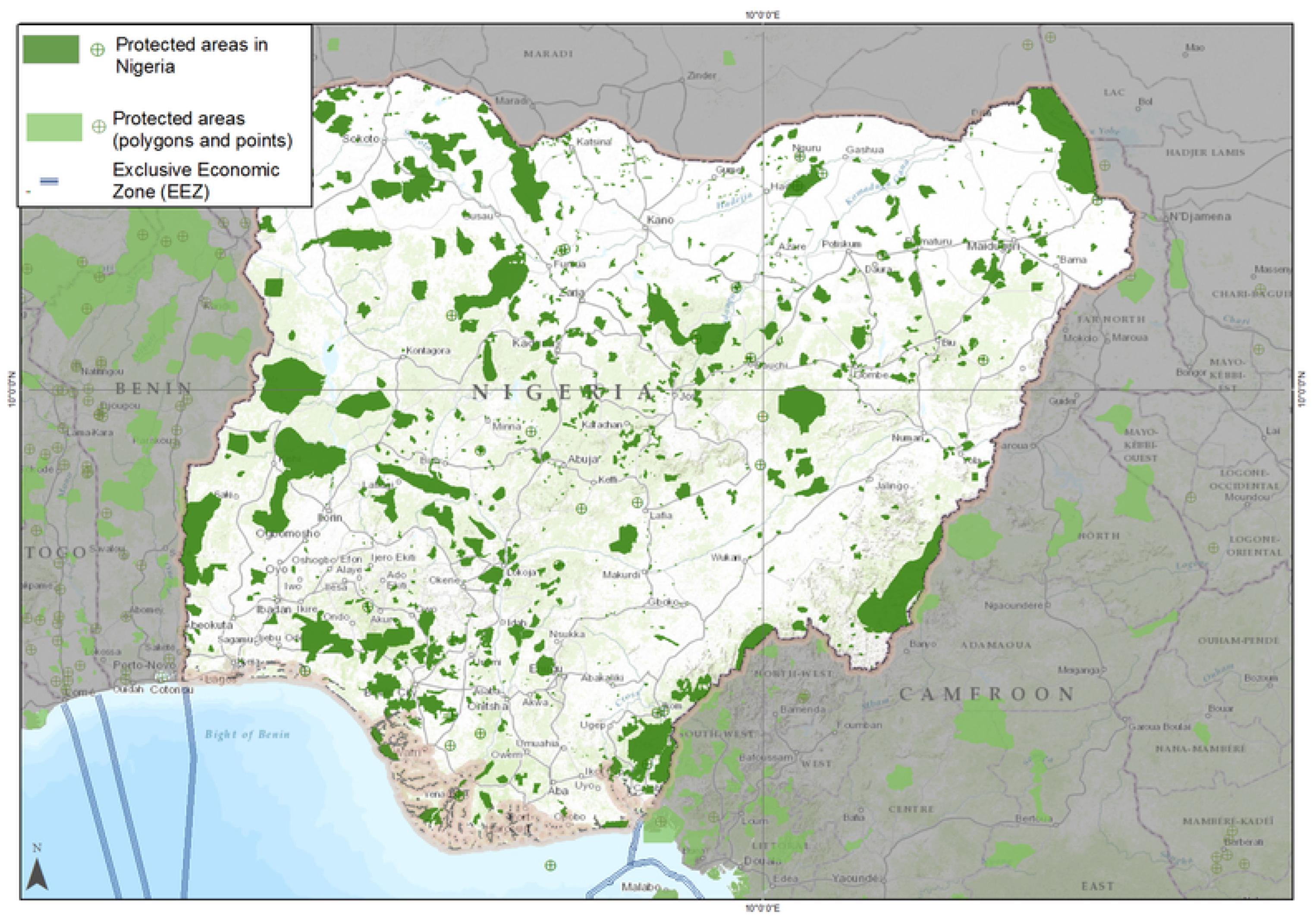
Figure 8.
Map of Nigeria Showing the Protected Areas and National Parks (Gashaka-Gumti National Park).
Figure 8.
Map of Nigeria Showing the Protected Areas and National Parks (Gashaka-Gumti National Park).
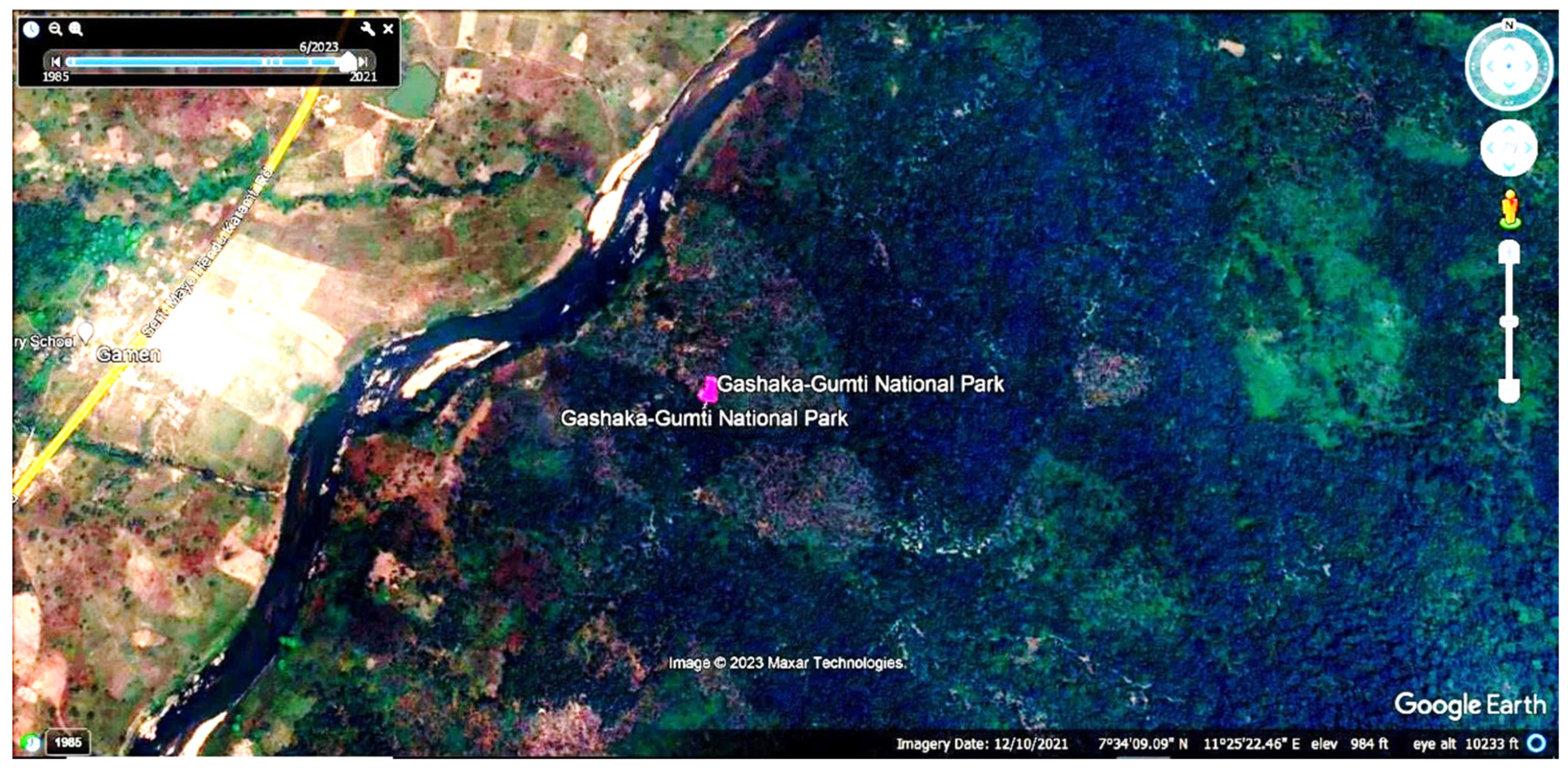
Figure 9.
LULC Map (Gashaka-Gumti National Park).
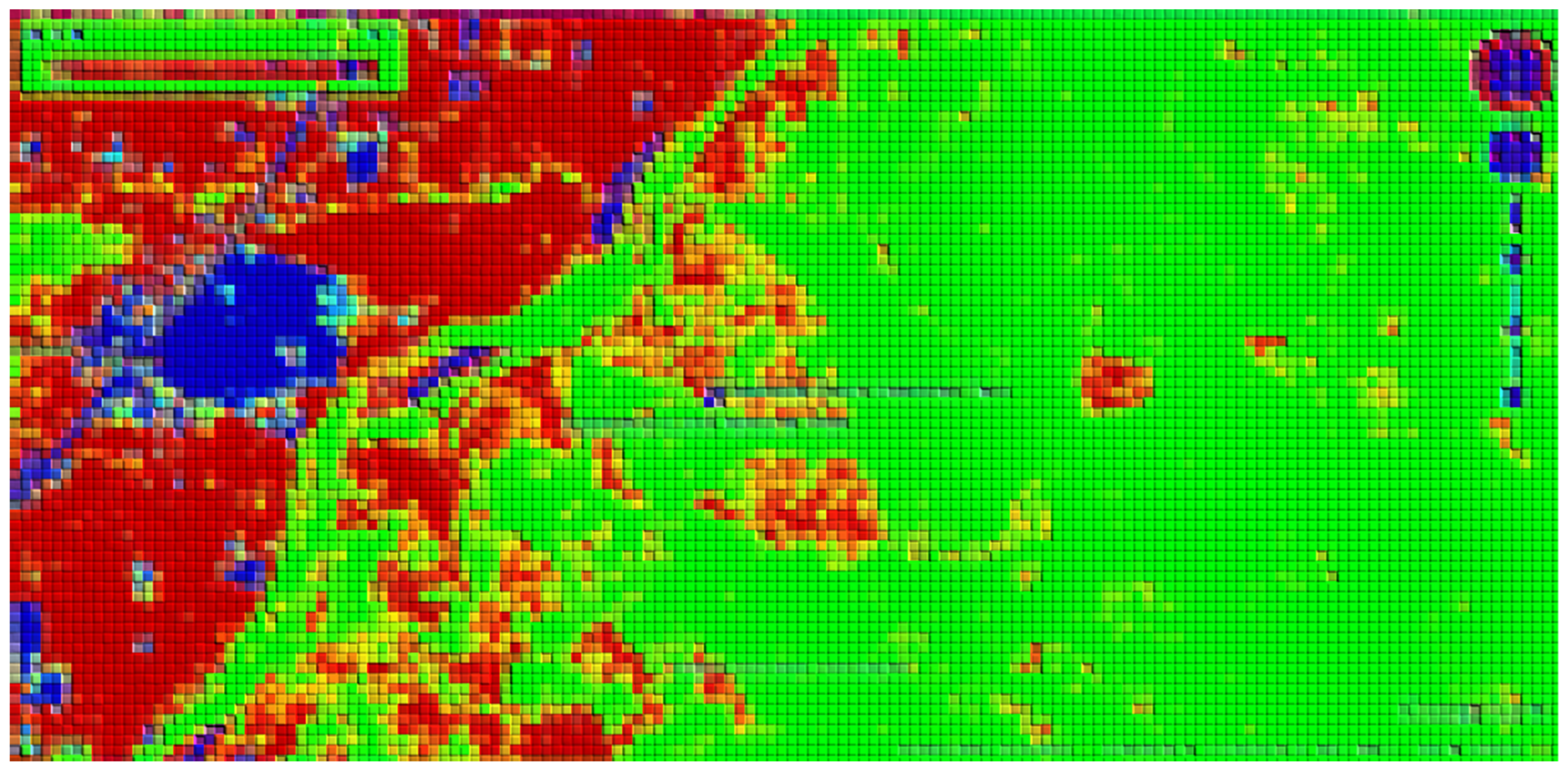
Figure 10.
Soil Type and Elevation Map (Gashaka-Gumti National Park) (five different dominant soil types).
Figure 10.
Soil Type and Elevation Map (Gashaka-Gumti National Park) (five different dominant soil types).
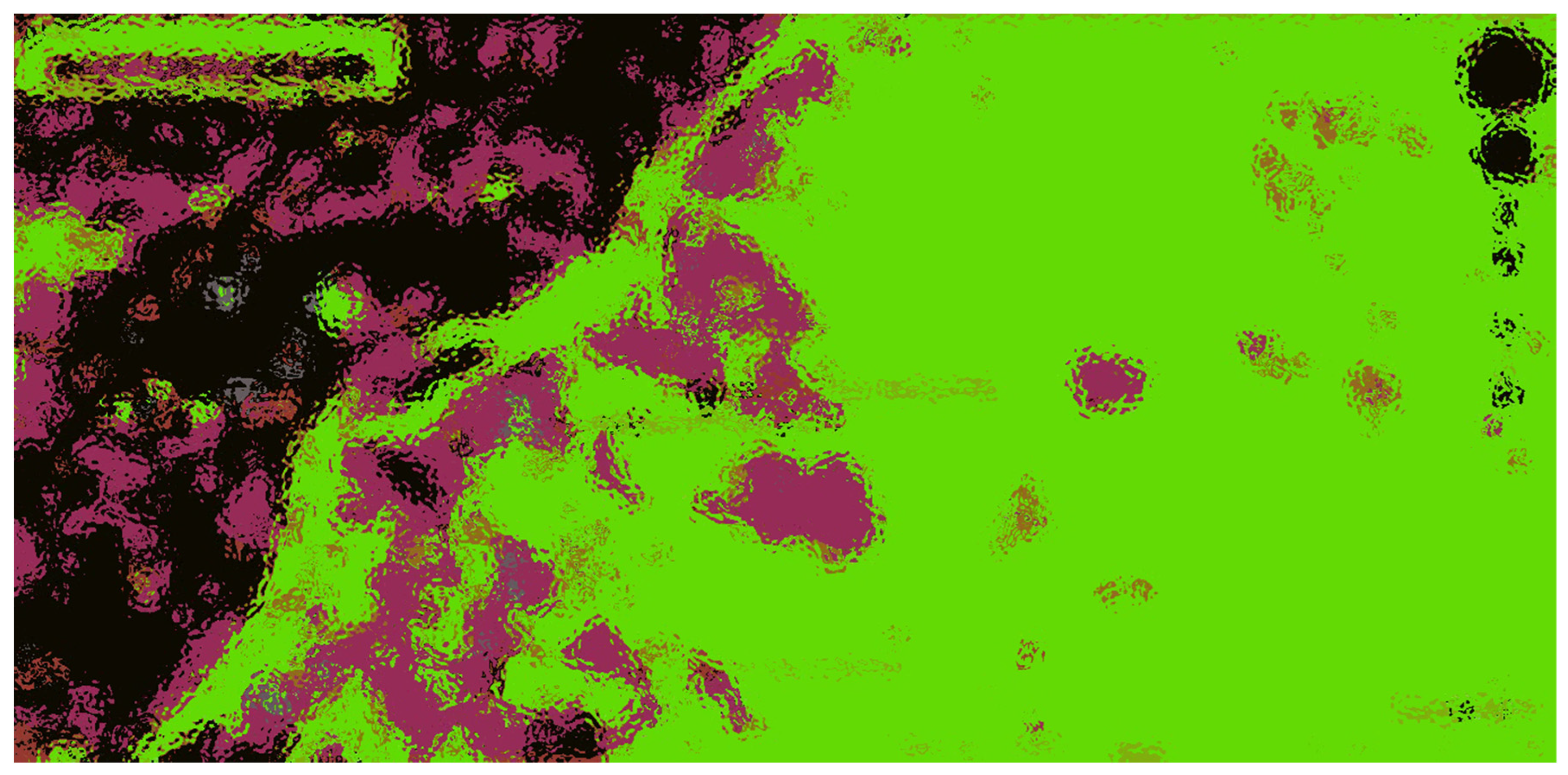

Table 1.
Checklist description and identification in the Study Area: The Land Use/Land Covers (LULC) types, vegetation, and demography in each of the identified 18 National Parks.
Table 1.
Checklist description and identification in the Study Area: The Land Use/Land Covers (LULC) types, vegetation, and demography in each of the identified 18 National Parks.
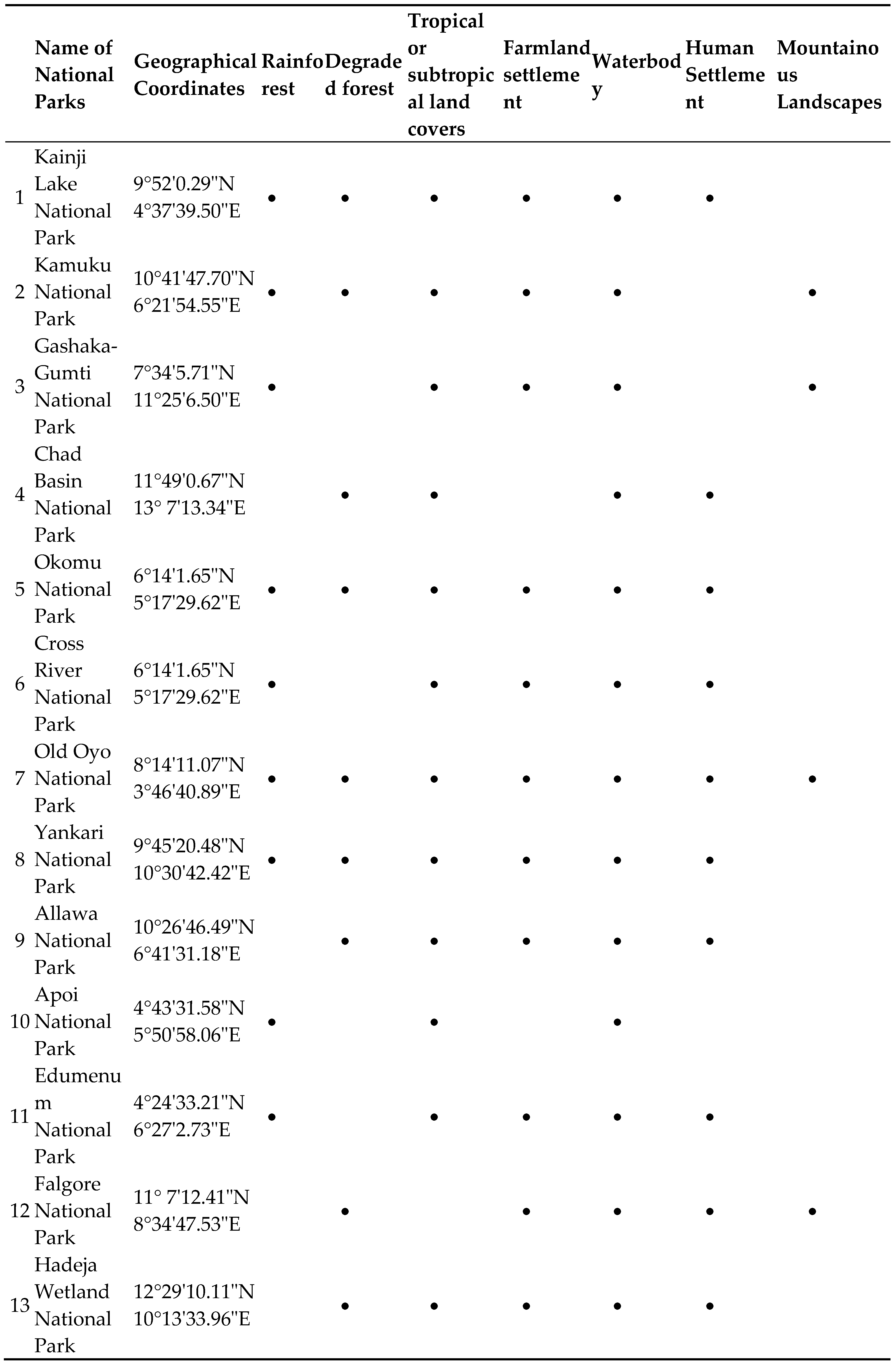
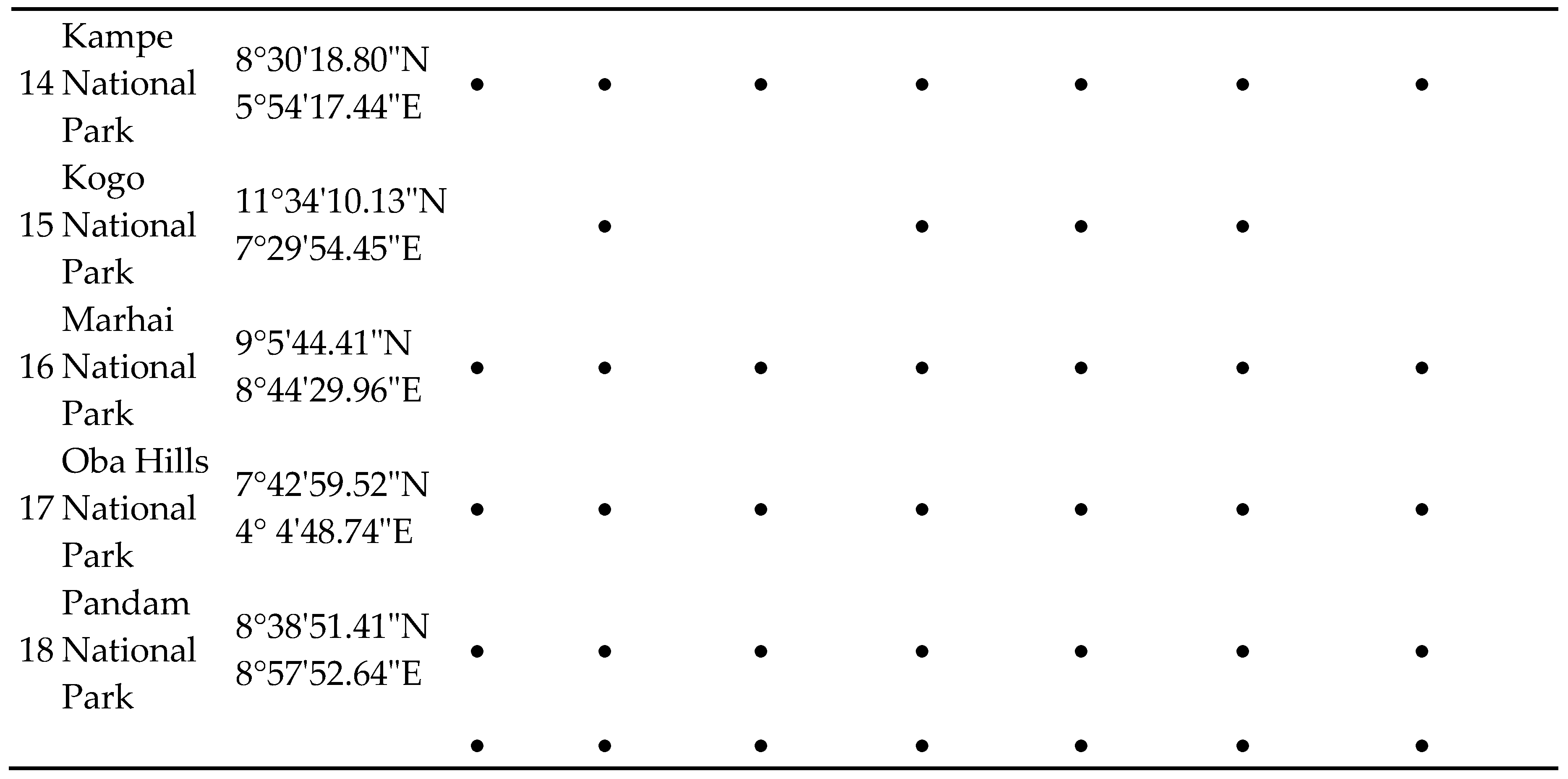
Table 2.
Table showing the various Locations of Eighteen National Parks and the Host States.
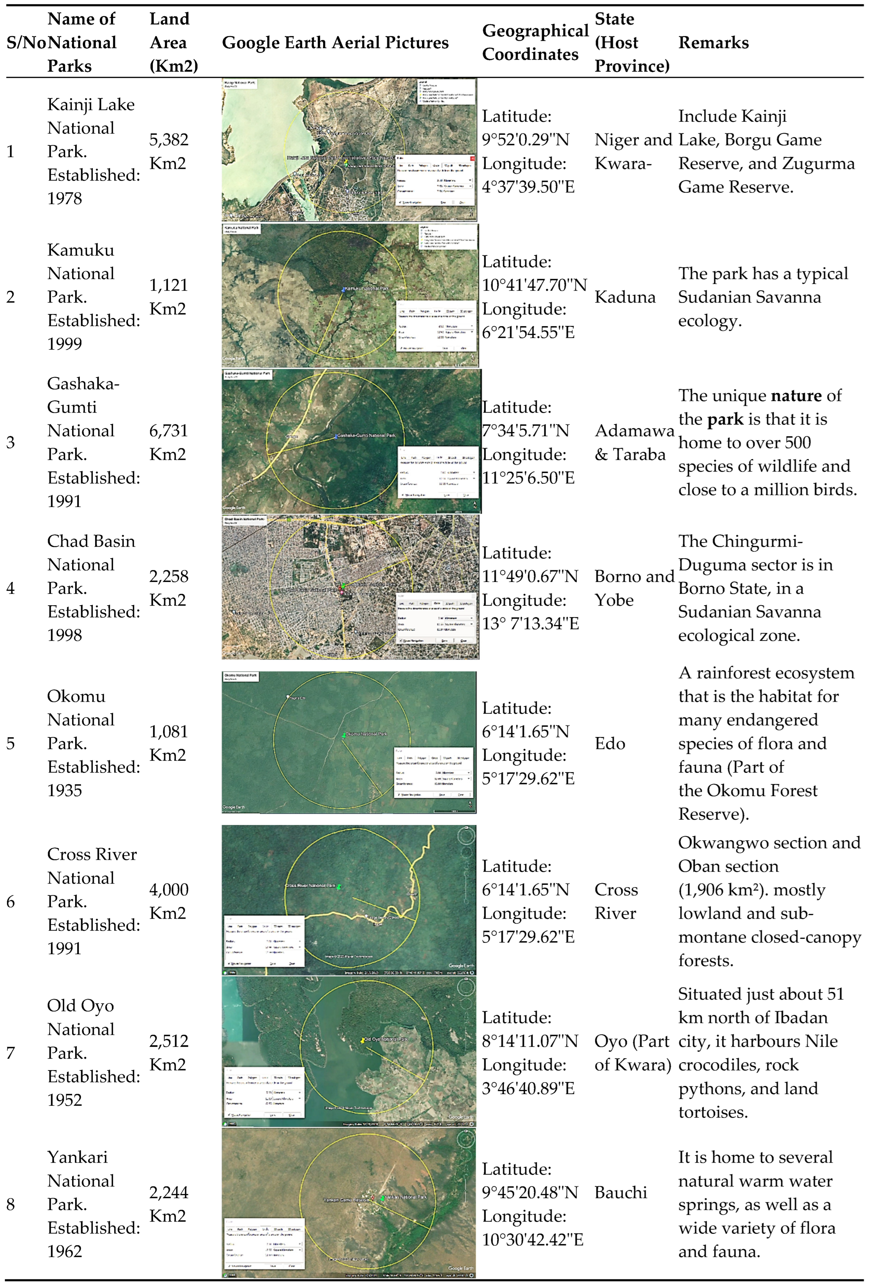
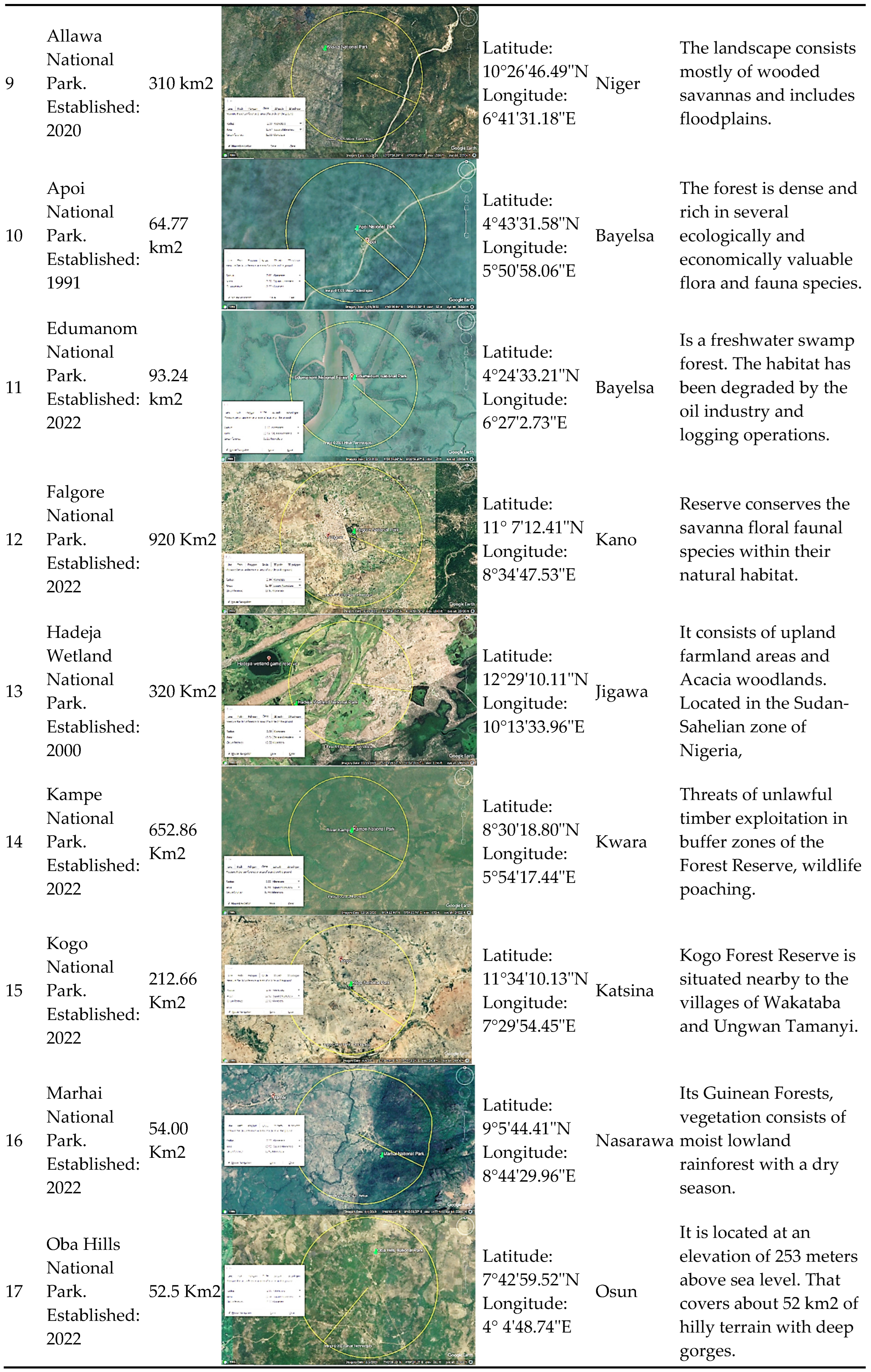
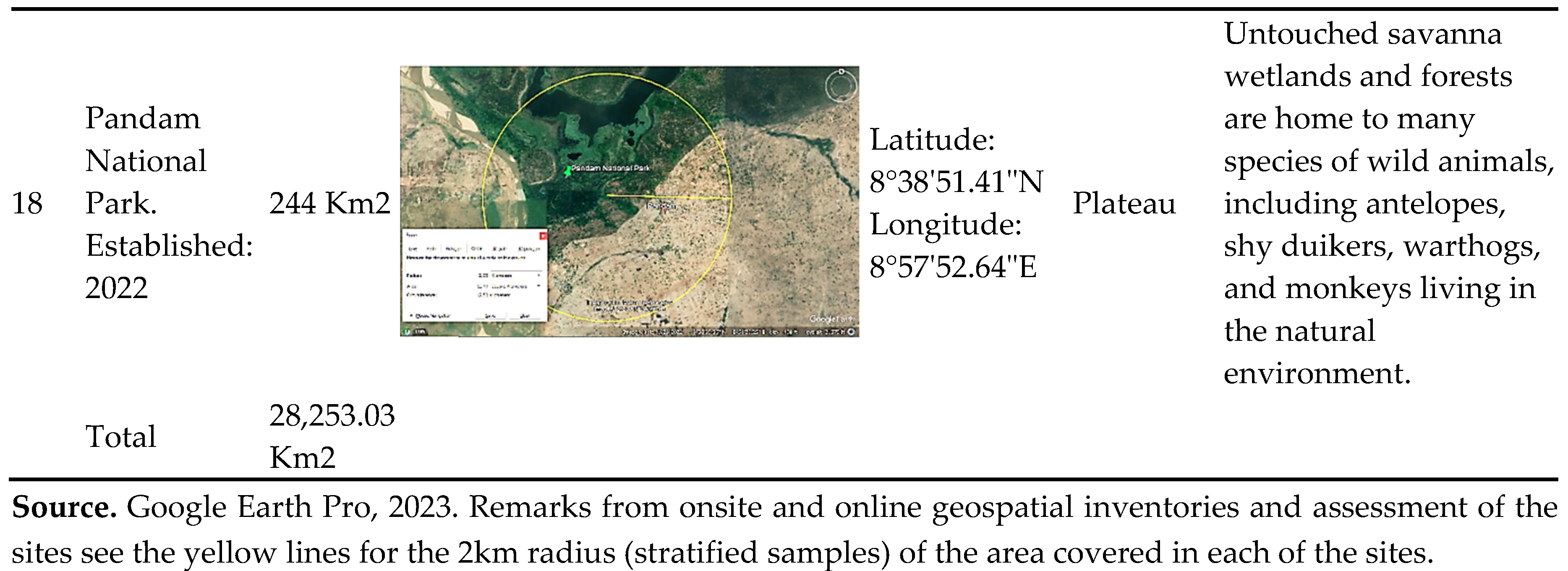
Table 3.
The Google Earth Pro, obtained Landsat pictures for the years 1985, 2011, 2013, 2017, 2020, and 2023, in no particular sequence but according to the availability of the map during this study.
Table 3.
The Google Earth Pro, obtained Landsat pictures for the years 1985, 2011, 2013, 2017, 2020, and 2023, in no particular sequence but according to the availability of the map during this study.
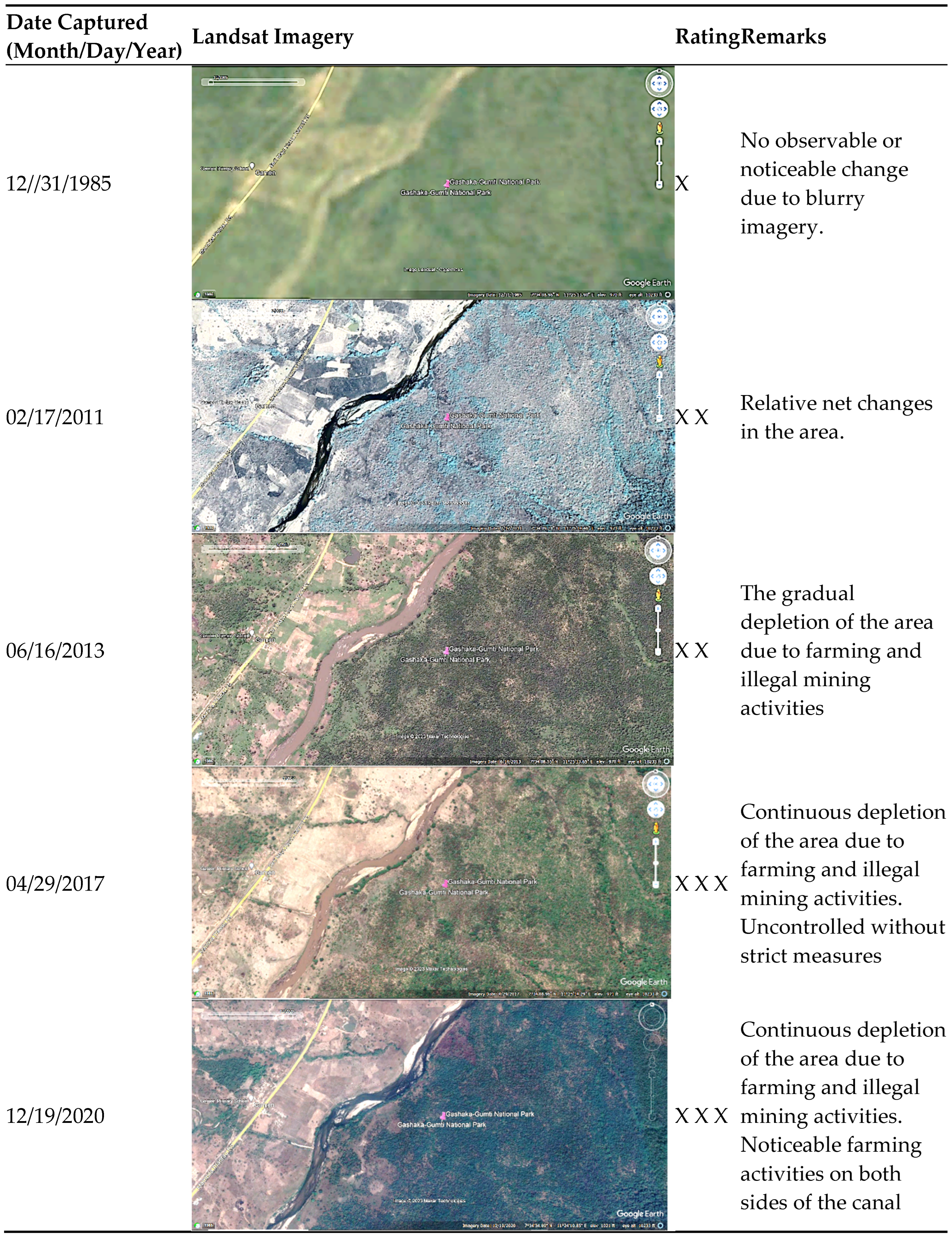
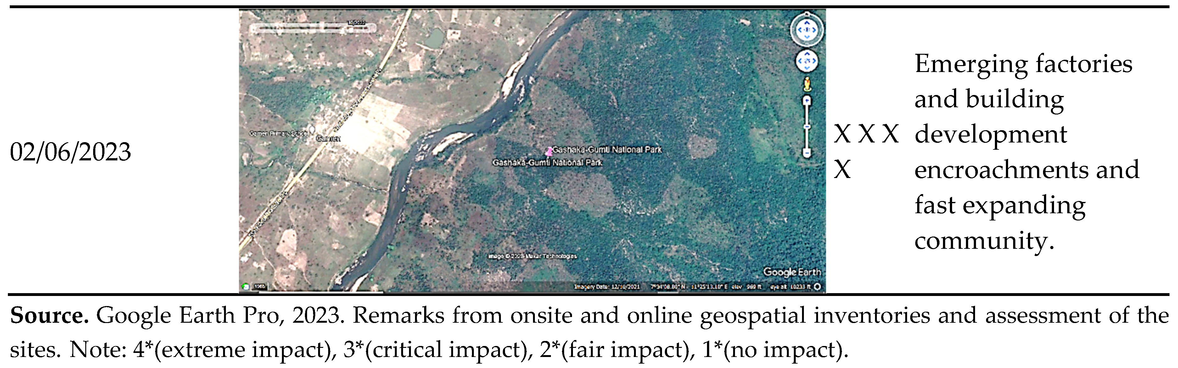
Disclaimer/Publisher’s Note: The statements, opinions and data contained in all publications are solely those of the individual author(s) and contributor(s) and not of MDPI and/or the editor(s). MDPI and/or the editor(s) disclaim responsibility for any injury to people or property resulting from any ideas, methods, instructions or products referred to in the content. |
© 2023 by the authors. Licensee MDPI, Basel, Switzerland. This article is an open access article distributed under the terms and conditions of the Creative Commons Attribution (CC BY) license (http://creativecommons.org/licenses/by/4.0/).
Copyright: This open access article is published under a Creative Commons CC BY 4.0 license, which permit the free download, distribution, and reuse, provided that the author and preprint are cited in any reuse.


