Submitted:
15 September 2023
Posted:
18 September 2023
You are already at the latest version
Abstract
Keywords:
1. Introduction
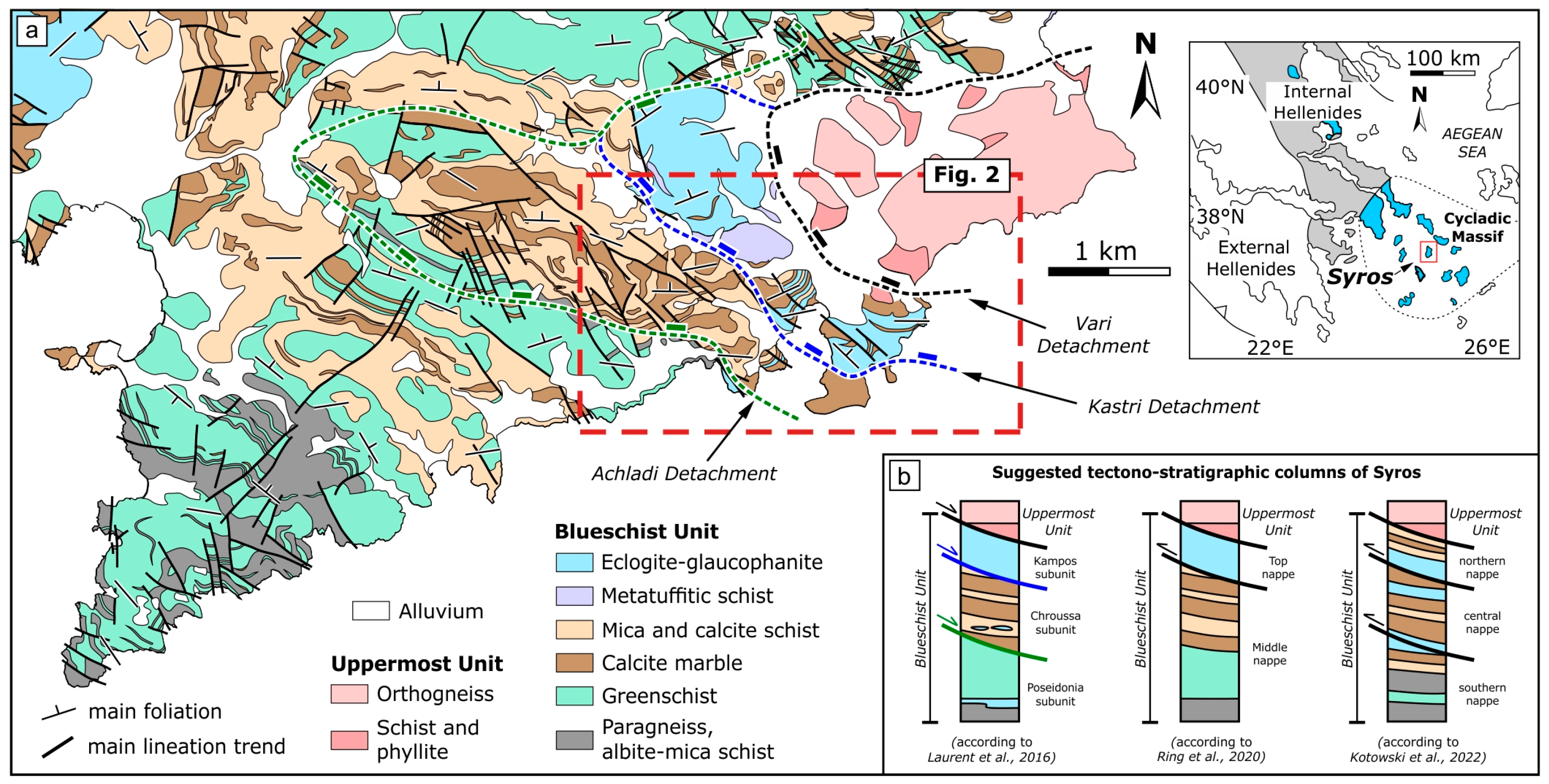
2. Geological and structural setting
3. Results
3.1. Mapping results
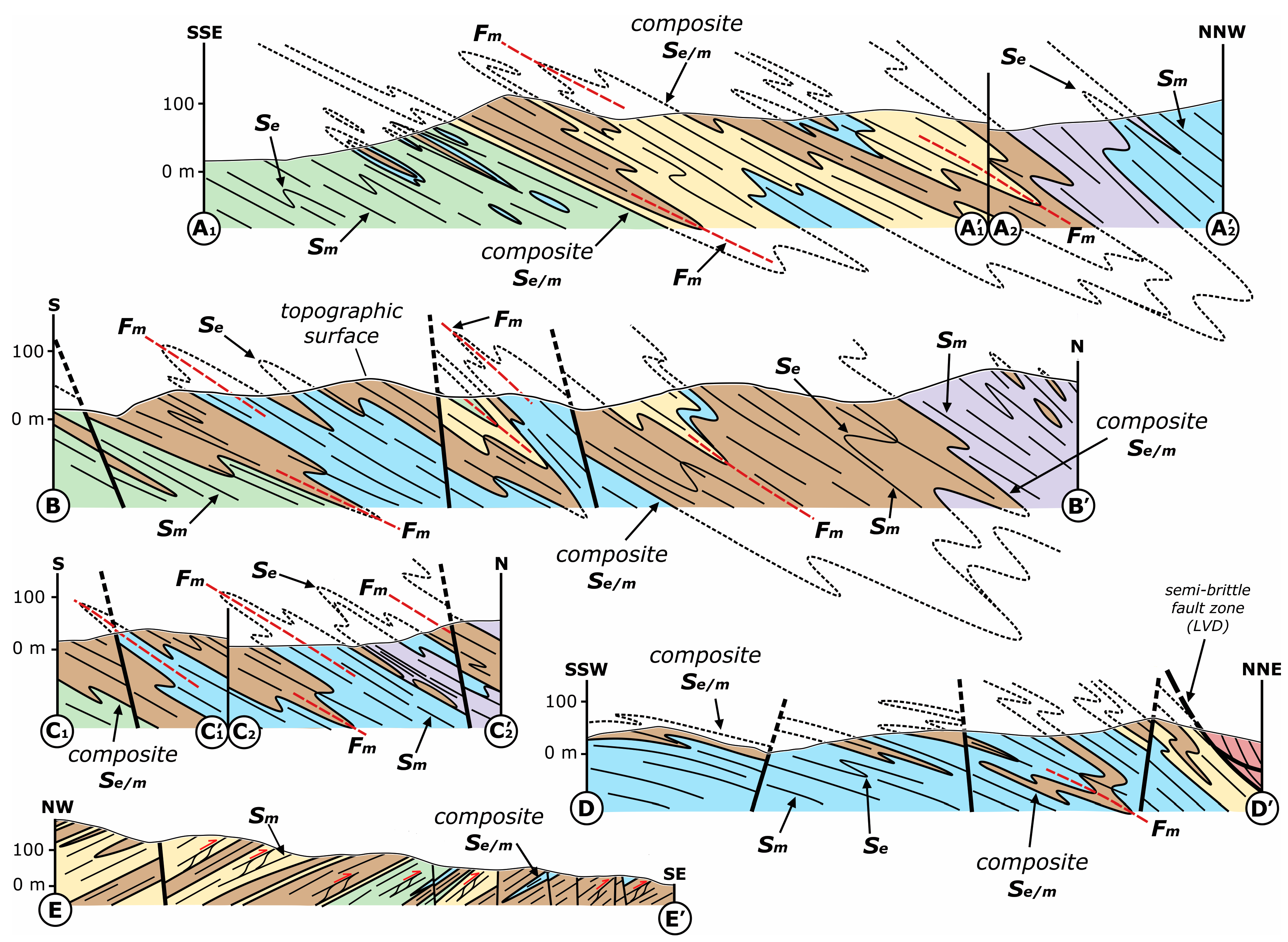
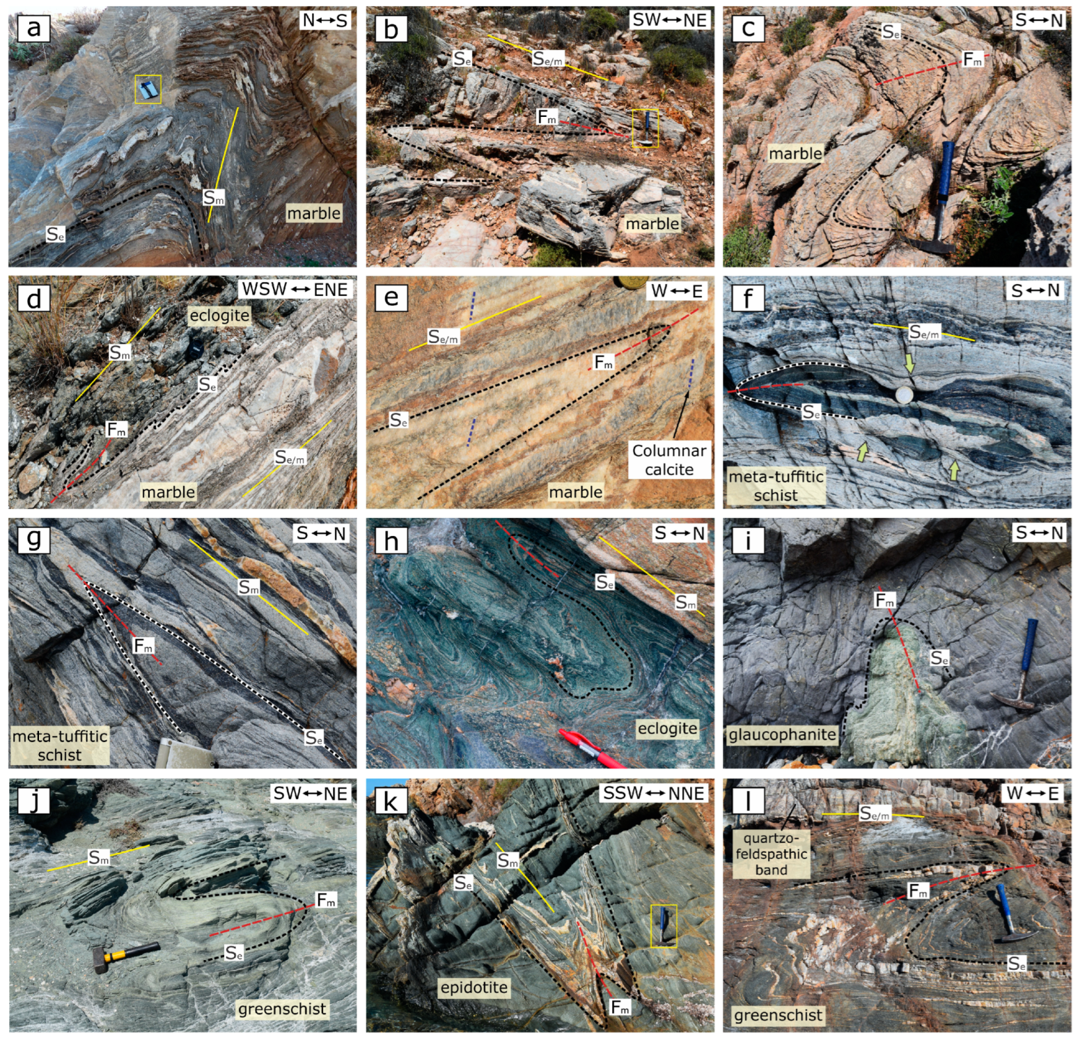
3.2. Structural analysis

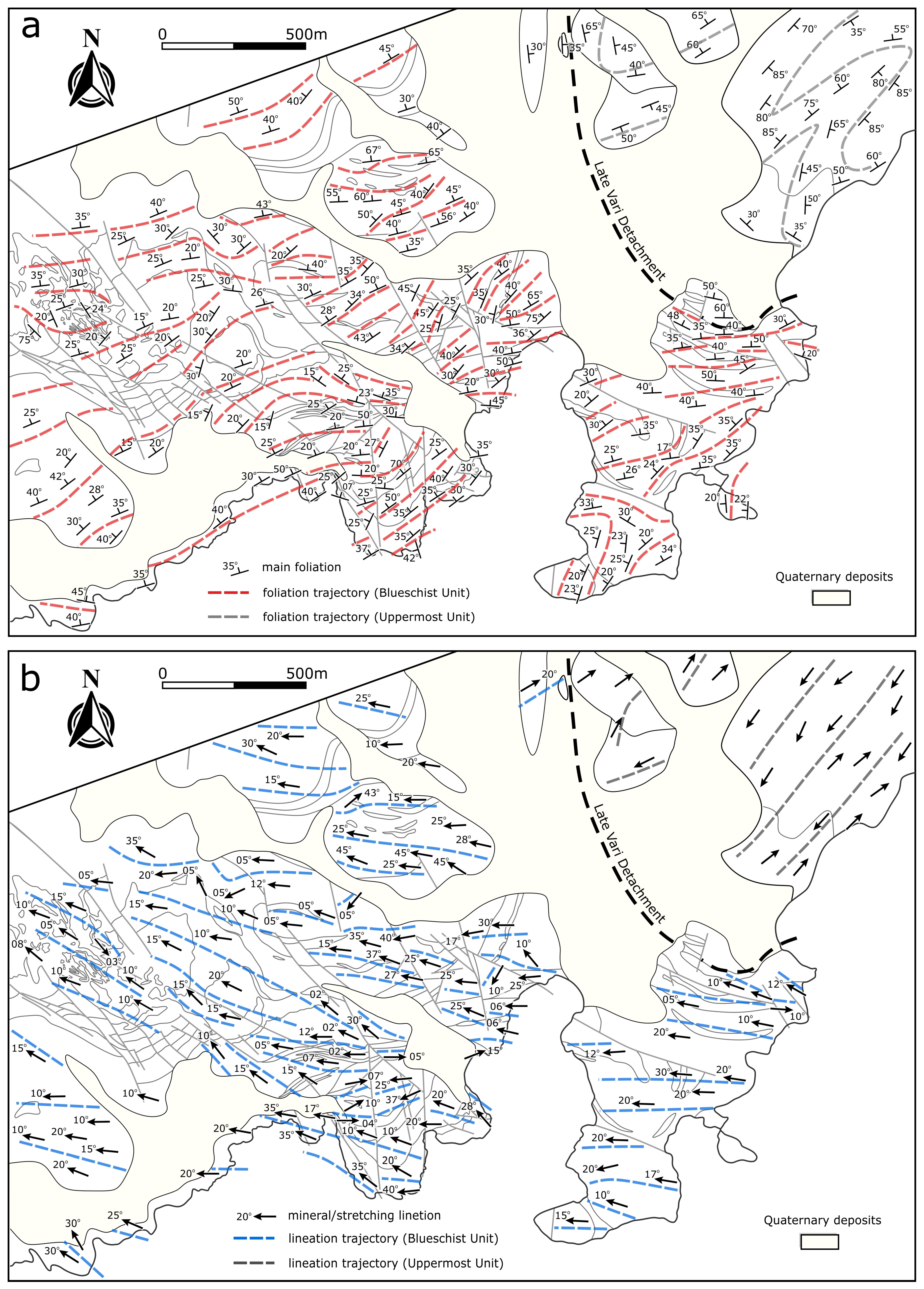
4. Discussion
4.1. Synthesis
4.2. Exhumation mode of the Blueschist Unit
5. Conclusions
- (1)
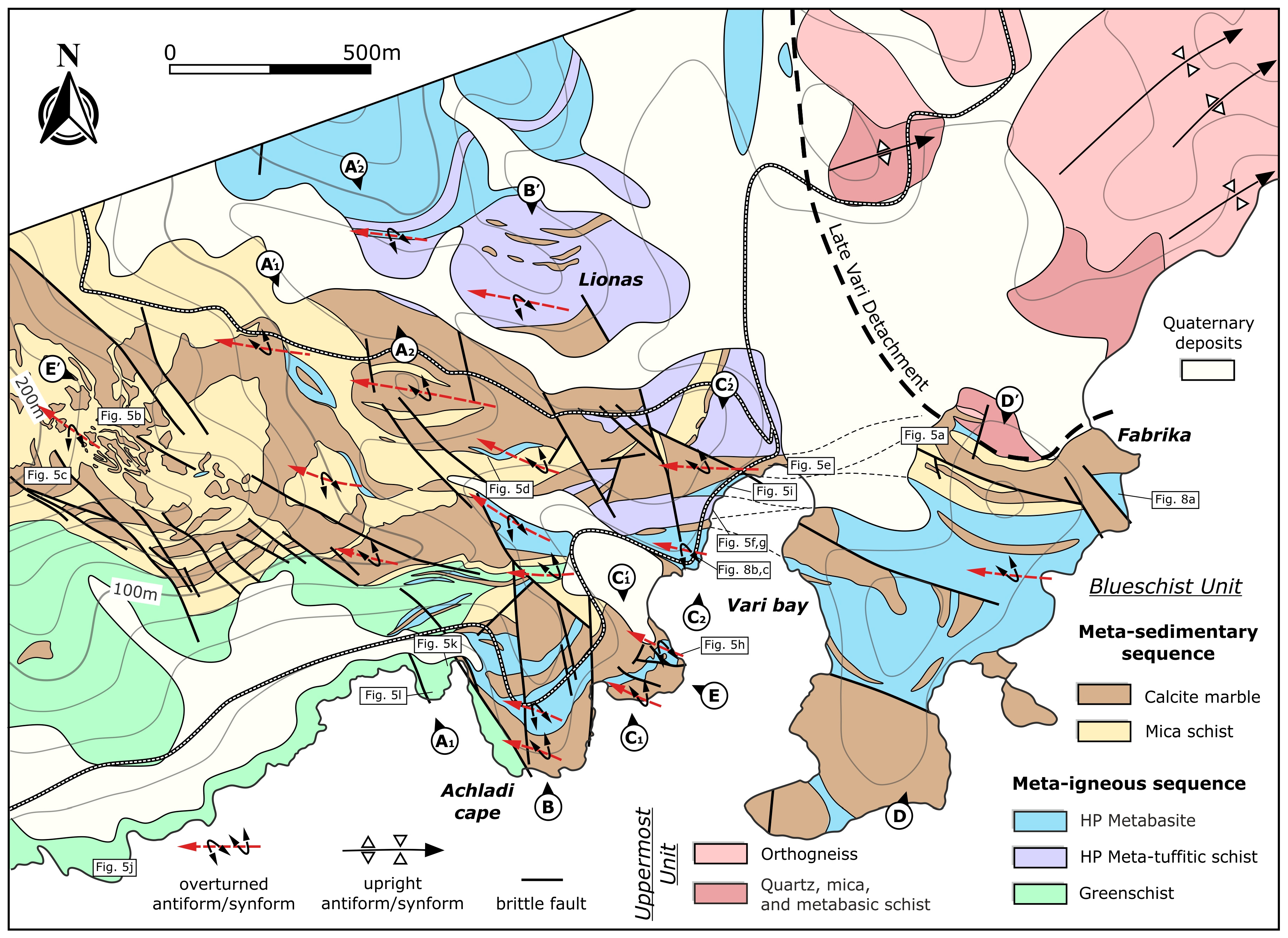
- Geological mapping revealed the occurrence of two main rock sequences, a metasedimentary underlain by a meta-igneous sequence, the contact of which displays an interfingering pattern on the map.
- (2)
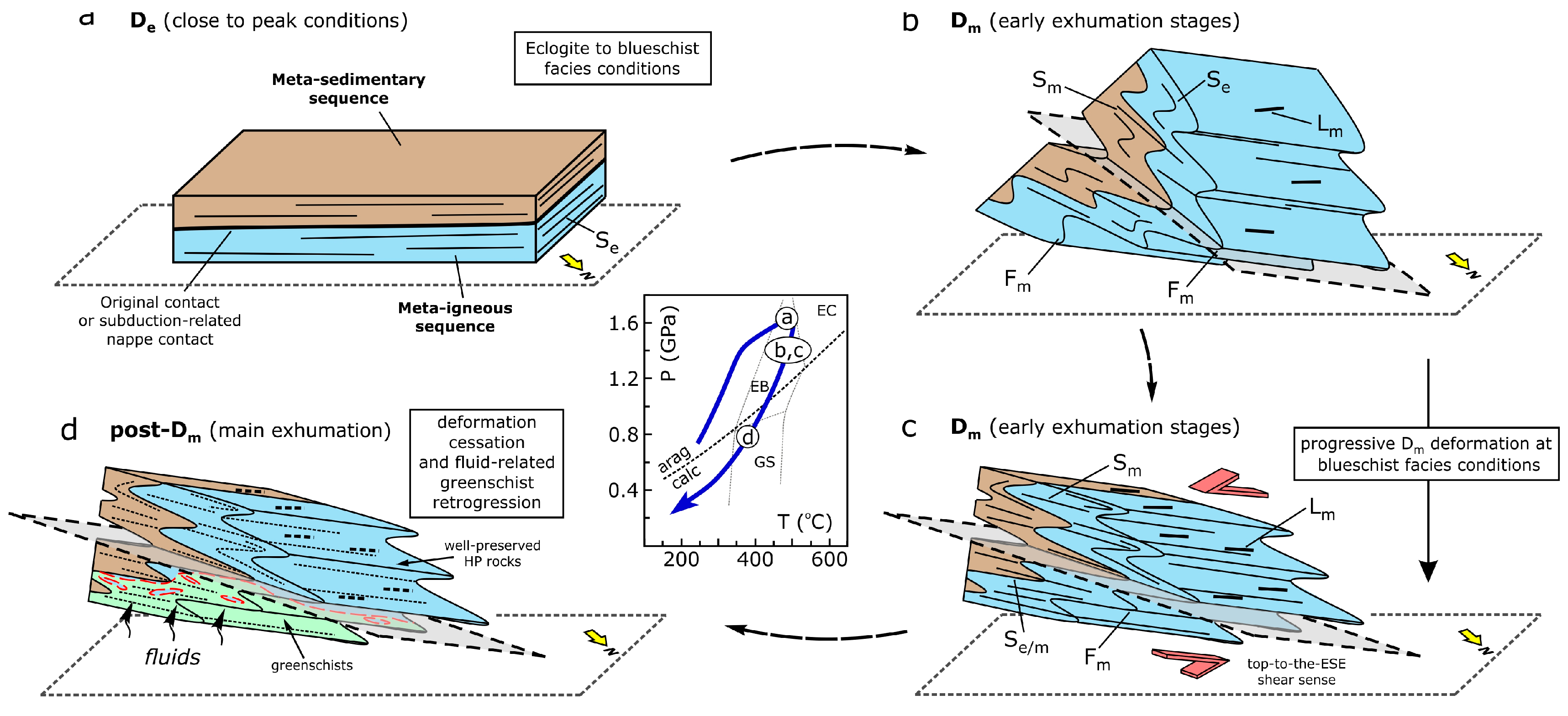
- The earlier ductile deformation (De) is linked to a penetrative foliation, which was formed at the deep subduction levels under eclogite/blueschist facies conditions.
- (3)
- The main deformation Dm operated at blueschist facies conditions synchronous with the early stages of exhumation of the high-pressure rocks. This phase is associated with the formation of map-scale folds that trend subparallel to a WNW-plunging lineation as well as with an axial planar foliation, which is typically related to an ESE-directed shearing.
- (4)
- During the main exhumation of the rocks from blueschist to greenschist facies conditions, deformation was weak or absent.
- (5)
- Greenschist retrogression observed in the southwestern part of the mapped area seems to be controlled by fluids rather than by intense deformation at greenschist facies conditions.
- (6)
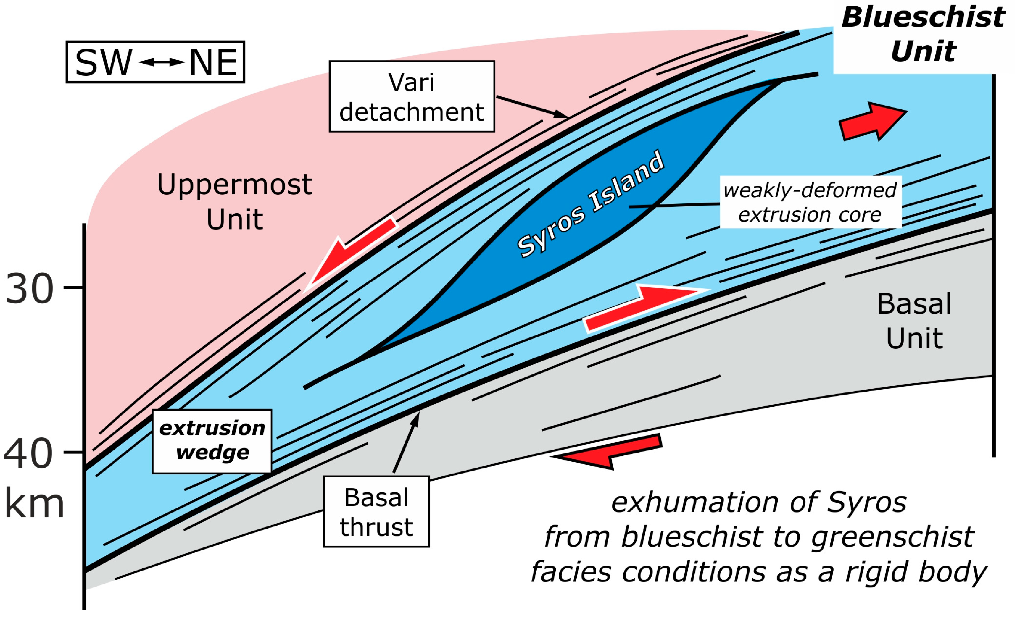
- Well-preserved HP rocks of the Blueschist Unit exposed on Syros Island represent a large-scale pod of low deformation under blueschist to greenschist facies conditions, which occupy the core of an extrusion wedge.
Author Contributions
Funding
Data Availability Statement
Conflicts of Interest
References
- Okrusch, M.; Bröcker, M. Eclogites associated with high grade blueschists in the Cyclades archipelago, Greece: a review. Eur. J. Mineral. 1990, 2, 451–478. [Google Scholar] [CrossRef]
- Keiter, M.; Ballhaus, C.; Tomaschek, F. A new geological map of the island of Syros (Aegean Sea, Greece): Implications for lithostratigraphy and structural history of the Cycladic Blueschist Unit. Geol. Soc. Am. Spec. 2011, 481, 1–43. [Google Scholar]
- Trotet, F.; Jolivet, L.; Vidal, O. Tectonometamorphic evolution of Syros and Sifnos islands (Cyclades, Greece). Tectonophysics. 2001, 338, 179–206. [Google Scholar] [CrossRef]
- Rosenbaum, G.; Avigad, D.; Sánchez-Gómez, M. Coaxial flattening at deep levels of orogenic belts: Evidence from blueschists and eclogites on Syros and Sifnos (Cyclades, Greece). J. Struct. Geol. 2002, 24, 1451–1462. [Google Scholar] [CrossRef]
- Keiter, M.; Piepjohn, K.; Ballhaus, C.; Lagos, M.; Bode, M. Structural development of high-pressure metamorphic rocks on Syros island (Cyclades, Greece). J. Struct. Geol. 2004, 26, 1433–1445. [Google Scholar] [CrossRef]
- Schumacher, J.C.; Brady, J.B.; Cheney, J.T.; Tonnsen, R.R. Glaucophane-bearing marbles on Syros, Greece. J. Petrol. 2008a, 49, 1667–1686. [Google Scholar] [CrossRef]
- Schumacher, J.C.; Brady, J.B.; Cheney, J.T. Metamorphic style and development of the blueschist- to eclogite-facies rocks, Cyclades, Greece. IOP Conf. Ser.: Earth Environ. Sci 2008b, 2, 012017. [Google Scholar] [CrossRef]
- Soukis, K.; Stockli, D.F. Structural and thermochronometric evidence for multi-stage exhumation of Southern Syros, Cycladic islands, Greece. Tectonophysics. 2013, 595, 148–164. [Google Scholar] [CrossRef]
- Laurent, V.; Jolivet, L.; Roche, V.; Augier, R.; Scaillet, S.; Cardello, G.L. Strain localization in a fossilized subduction channel: insights from the Cycladic Blueschist Unit (Syros, Greece). Tectonophysics 2016, 672–673, 150–169. [Google Scholar] [CrossRef]
- Laurent, V.; Huet, B.; Labrousse, L.; Jolivet, L.; Monié, P.; Augier, R. Extraneous argon in high-pressure metamorphic rocks: Distribution, origin and transport in the Cycladic Blueschist Unit (Greece). Lithos. 2017, 272–273, 315–335. [Google Scholar] [CrossRef]
- Aravadinou, E.; Xypolias, P. Evolution of a passive crustal-scale detachment (Syros, Aegean region): Insights from structural and petrofabric analyses in the hanging-wall. J. Struct. Geol. 2017, 103, 57–74. [Google Scholar] [CrossRef]
- Aravadinou, E.; Gerogiannis, N.; Xypolias, P. Development and passive exhumation of high-pressure shear zones (Blueschist Unit, Syros): insights from quartz and columnar calcite microstructures. J. Struct. Geol. 2022, 159, 104607. [Google Scholar] [CrossRef]
- Kotowski, A.J.; Behr, W.M.; Cisneros, M.; Daniel, F.; Soukis, K.; Barnes, J.D.; Ortega Arroyo, D. Subduction, underplating, and return flow recorded in the Cycladic Blueschist Unit exposed on Syros, Greece: Tectonics. 2022, 41, e2020TC006528. 2022, 41, e2020TC006528. [Google Scholar] [CrossRef]
- Jolivet, L.; Brun, Ζ.J.P. Cenozoic geodynamic evolution of the Aegean. Int. J. Earth Sci. 2010, 99, 109–138. [Google Scholar] [CrossRef]
- Xypolias, P.; Kokkalas, S.; Skourlis, K. Upward extrusion and subsequent transpression as a possible mechanism for the exhumation of HP/LT rocks in Evia Island (Aegean Sea, Greece). J Geodyn. 2003, 35, 303–332. [Google Scholar] [CrossRef]
- Xypolias, P.; Iliopoulos, I.; Chatzaras, V.; Kokkalas, S. Subduction- and exhumation-related structures in the Cycladic blueschists: insights from south Evia island (Aegean region, Greece). Tectonics. 2012, 31, TC2001. [Google Scholar] [CrossRef]
- Ring, U.; Glodny, J.; Will, T.; Thomson, S.N. An Oligocene extrusion wedge of blueschist-facies nappes on Evia, Aegean Sea, Greece: implications for the early exhumation of high-pressure rocks. J. Geol. Soc. London. 2007, 164, 637–652. [Google Scholar] [CrossRef]
- Gerogiannis, N.; Xypolias, P.; Chatzaras, V.; Aravadinou, E.; Papapavlou, K. Deformation within the Cycladic subduction-exhumation channel: new insights from the enigmatic Makrotantalo nappe (Andros, Aegean). Int. J. Earth Sci. 2019, 108, 817–843. [Google Scholar] [CrossRef]
- Ring, U.; Pantazides, H.; Glodny, J.; Skelton, A. Forced return flow deep in the subduction channel, Syros, Greece. Tectonics 2020, 39. [Google Scholar] [CrossRef]
- Dürr, S. Das Attisch-Kykladische Kristallin. In Geologie von Griechenland; Jacobshagen, V., Eds.; Berlin, Bornträger, Germany, 1986; pp. 116–148.
- Uunk, B.; Brouwer, F.; de Paz-Álvarez, M.; van Zuilen, K.; Huybens, R.; van ’t Veera, R.; Wijbrans, J. Consistent detachment of supracrustal rocks from a fixed subduction depth in the Cyclades. Earth Planet. Sci. Lett. 2022, 584, 117479. [Google Scholar] [CrossRef]
- Laurent, V.; Scaillet, S.; Jolivet, L.; Augier, R.; Roche, V. 40Ar behaviour and exhumation dynamics in a subduction channel from multi-scale 40Ar/39Ar systematics in phengite. Geochim. Cosmochim. Acta. 2021, 311, 141–173. [Google Scholar] [CrossRef]
- Gyomlai, T.; Agard, P.; Marschall, H.R.; Jolivet, L.; Gerdes, A. Metasomatism and deformation of block-in-matrix structures in Syros: The role of inheritance and fluid-rock interactions along the subduction interface. Lithos 2021, 386–387, 105996. [Google Scholar] [CrossRef]
- Bröcker, M.; Enders, M. Unusual bulk-rock compositions in eclogite-facies rocks from Syros and Tinos (Cyclades, Greece): implications for U–Pb zircon geochronology. Chem. Geol 2001, 175, 581–603. [Google Scholar] [CrossRef]
- Tomaschek, F.; Kennedy, A.; Villa, I.; Lagos, M.; Ballhaus, C. Zircons from Syros, Cyclades, Greece-Recrystallization and mobilization of zircon during high-pressure metamorphism. J. Petrol. 2003, 44, 1977–2002. [Google Scholar] [CrossRef]
- Cliff, R.A.; Bond, C.E.; Butler, R.W.H.; Dixon, J.E. Geochronological challenges posed by continuously developing tectonometamorphic systems: insights from Rb–Sr mica ages from the Cycladic Blueschist Belt, Syros (Greece). J. Metamorph. Geol. 2017, 35, 197–211. [Google Scholar] [CrossRef]
- Skelton, A.; Peillod, A.; Glodny, J.; Klonowska, I.; Månbro, C.; Lodin, K.; Ring, U. Preservation of high-P rocks coupled to rock composition and the absence of metamorphic fluids. J. Metamorph. Geol. 2019, 37(3), 359–381. [Google Scholar] [CrossRef]
- Cisneros, M.; Barnes, J.D.; Behr, W.M.; Kotowski, A.J.; Stockli, D.F.; Soukis, K. Insights from elastic thermobarometry into exhumation of high-pressure metamorphic rocks from Syros, Greece. Solid Earth 2021, 12, 1335–1355. [Google Scholar] [CrossRef]
- Bröcker, M.; Baldwin, S.; Arkudas, R. The geological significance of 40Ar/39Ar and Rb-Sr white mica ages from Syros and Sifnos, Greece: a record of continuous (re) crystallization during exhumation? J. Metamorph. Geol. 2013, 31, 629–646. [Google Scholar] [CrossRef]
- Ridley, J. Tectonic Style, Strain History, and Fabric Development in a Blueschist Terrain, Syros, Greece. PhD thesis, Edinburgh University, Edinburgh, 1982a, 283.
- Ridley, J.R. The significance of deformation associated with blueschist facies metamorphism on the Aegean island of Syros. Geol. Soc. Spec. Publ. 1984, 17, 545–550. [Google Scholar] [CrossRef]
- Philippon, M.; Brunn, J.P.; Gueydan, F. Tectonics of the Syros blueschists (Cyclades, Greece): from subduction to Aegean extension. Tectonics. 2011, 30, TC4001. [Google Scholar] [CrossRef]
- Ridley, J. Arcuate lineation trends in a deep level, ductile thrust belt, Syros, Greece. Tectonophysics. 1982b, 88, 347–360. [Google Scholar] [CrossRef]
- Barr, H.M. Fluid-rock interactions during blueschist and greenschist metamorphism in the Aegean area of Greece. PhD thesis, Edinburgh University, Edinburgh, 1989.
- Bond, C.E.; Butler, R.W.H.; Dixon, J.E. Co-axial horizontal stretching within extending orogens: The exhumation of HP rocks on Syros (Cyclades) revisited. Geol. Soc. Spec. Publ. 2007, 272(1), 203–222. [Google Scholar] [CrossRef]
- Glodny, J.; Ring, U. The Cycladic Blueschist Unit of the Hellenic subduction orogen: Protracted high-pressure metamorphism, decompression and reimbrication of a diachronous nappe stack. Earth. Sci. Rev. 2022, 224, 103883. [Google Scholar] [CrossRef]
- Brady, J.B.; Markley, M.J.; Schumacher, J.C.; Cheney, J.T.; Bianciardi, G.A. Aragonite pseudomorphs in high-pressure marbles of Syros, Greece. J. Struct. Geol. 2004, 26, 3–9. [Google Scholar] [CrossRef]
- Fleuty, M.J. The description of folds. Proc. Geol. Assoc. 1964, 75, 461–492. [Google Scholar] [CrossRef]
- Aravadinou, E.; Xypolias, P.; Chatzaras, V.; Iliopoulos, I.; Gerogiannis, N. Ductile nappe stacking and refolding in the Cycladic Blueschist Unit: insights from Sifnos Island (south Aegean Sea). Int. J. Earth. Sci. 2016, 105, 2075–2096. [Google Scholar] [CrossRef]
- Gerogiannis, N.; Aravadinou, E.; Chatzaras, V.; Xypolias, P. Calcite pseudomorphs after aragonite: A tool to unravel the structural history of high-pressure marbles (Evia Island, Greece). J. Struct. Geol. 2021, 148, 104373. [Google Scholar] [CrossRef]
- Godin, L.; Grujic, D.; Law, R.D.; Searle, M.P. Channel flow, ductile extrusion and exhumation in continental collision zones: An introduction. In Channel Flow, Ductile Extrusion and Exhumation in Continental Collision Zones; Law, R.D., Searle, M.P., Godin, L., Eds.; Geol. Soc. Spec. Publ., London, 2006; 268, pp. 1–23. [CrossRef]


Disclaimer/Publisher’s Note: The statements, opinions and data contained in all publications are solely those of the individual author(s) and contributor(s) and not of MDPI and/or the editor(s). MDPI and/or the editor(s) disclaim responsibility for any injury to people or property resulting from any ideas, methods, instructions or products referred to in the content. |
© 2023 by the authors. Licensee MDPI, Basel, Switzerland. This article is an open access article distributed under the terms and conditions of the Creative Commons Attribution (CC BY) license (http://creativecommons.org/licenses/by/4.0/).


