

Submitted:
03 July 2023
Posted:
04 July 2023
You are already at the latest version
Abstract
Soil erosion due to soil erosion is an important ecological impact factor. In order to further explore the impact and contribution of soil and water conservation measures on sand production and transport in the watershed, and also to provide a reference for soil erosion control, soil and water conservation and ecological environmental protection in the Yellow River Basin. In this paper, based on the measured data from the Henan Soil and Water Conservation Observatory in the Yellow River Basin, we select appropriate equations for quantifying soil erosion factor to calculate the rainfall erosion, topography, soil, vegetation and soil conservation measures in the basin, and then analyse the changes in soil erosion factor and the actual benefits of soil conservation measures in the basin. The results show that there is an increasing trend in the rainfall erosion force factor R in the Yellow River Basin; Soil erosion can be K value made the vertical loess > yellow clunamon soil, the overall change shows a decreasing trend, indicating that erosion control has produced results and that attention should be paid to erosion control in the lithosol region in the future; Since the slope lengths of the runoff plots are laid out consistently with the same LS values for both topographic factors, soil erosion is severely increased when the slope exceeds 20°. The C value of natural vegetation is small, while the C value of bare land is large. The authorities should continue to promote the return of farmland to forests and grasses and pay attention to the self-regulation and restoration of ecosystems; There is an overall decreasing trend in the P value of the soil and water conservation measures factor, the soil and water conservation measures have been effective in providing good protection.
Keywords:
soil erosion factor
; soil and water conservation
; runoff plots
; site observations
; the Yellow River Basin
1. Introduction
Due to the comprehensive influence of climate, landform, vegetation, soil and human activities [1,2,3], the Yellow River Basin has a wide area of soil erosion and has become one of the most serious soil erosion areas in China [4]. Soil erosion factor is a key technical basis for scientific and comprehensive soil and water conservation management and ecological protection, and the use of site observations is one of the most effective ways to determine the regional soil erosion factor. Scholars at home and abroad have established different empirical models of soil erosion by combining the Universal Soil Loss Equation (USLE) and the Revised Universal Soil Loss Equation (RUSLE) with the local soil erosion characteristics of the study area [5,6,7], and have made rich research results in quantitative evaluation of soil erosion characteristics in different areas using the models [8,9,10]. Liu Baoyuan established the Chinese Soil Loss Equation (CSLE) [11], which more realistically reflects the soil erosion process in China. Soil and water conservation monitoring stations in Henan Province have accumulated serial actual measurement data on rainfall characteristics, vegetation types, soil moisture, vegetation cover and rainfall, and the selection of an applicable model to quantify soil erosion factors in Henan and analyse the characteristics of changes can provide technical support for soil erosion control and ecological environmental protection, which is conducive to improving theoretical research on soil erosion and soil erosion in the basin and the comprehensive management and information of soil and water conservation, and achieving high-quality development in the Yellow River Basin.
2. Study Area and Data
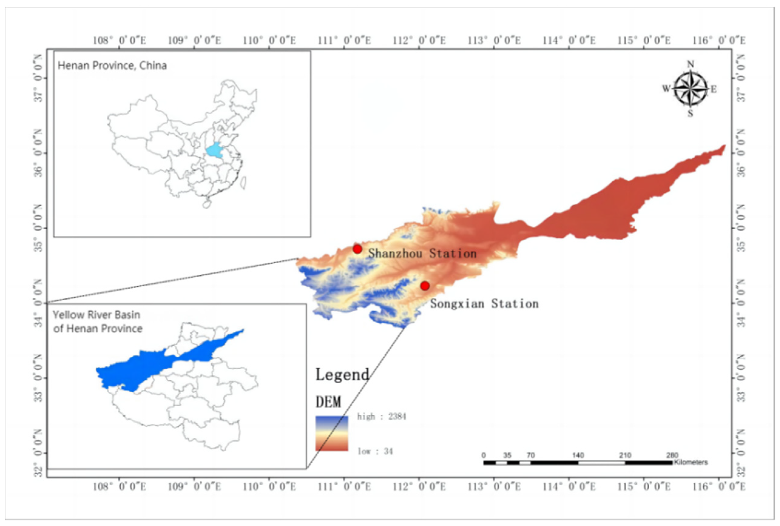
In Henan, which spans four major river basins: the Huai River, the Yangtze River, the Yellow River and the Hai River, a total of one main soil and water conservation monitoring station and six monitoring sub-stations were built. Shanxi water and soil conservation scientific experiment station is located at the outlet of the Jinshui River sub-basin, with a geographical location of 111°15′04″E and 34°38′27″N. The main channel is 6.0km long, with a relative height difference of 165m, the average longitudinal ratio drop of the main channel is 0.028, and the watershed area is 10.10km2, which is a first-class tributary of the Yellow River. The main soil type is standing loess, with a deep, loose texture; the vegetation type trees are mainly acacia trees, tung trees and poplar trees. Warm temperate continental monsoon climate; erosion is mainly hydraulic erosion, mainly surface erosion and gully erosion. The Songxian soil and water conservation scientific experiment station is located at the outlet of the Hugou watershed, representing the soil erosion characteristics of the Loess Hills area in western Henan in the Yellow River Basin.
Runoff, sediment and meteorological observations were carried out in the basin from 1981 to 2020 (measurements were suspended from 1991 to 2011 due to objective factors). The data from the meteorological observation stations, small watershed handle stations and runoff cell observation sites established by two stations located in the Yellow River Basin, Shanzhou Station and Songxian Station, from 2012 to 2020, were selected for the calculation of soil erosion factor and the analysis of change characteristics in the Yellow River Basin to provide a basis for the prevention and control of soil erosion in the Yellow River Basin.
Figure 1.
Location map of the research area.
3. Soil Erosion Factor Quantification Equation
According to the basic characteristics of the two stations built for soil erosion monitoring and soil erosion observation in the Yellow River Basin, Shanzhou station and Songxian station, the characteristics of rainfall and rain intensity, soil erosion intensity, slope length, vegetation cover and type of soil and water conservation measures in the area where the stations are located, the content of the original data and recorded time series of the station observations were used to select quantitative applicable equations for R, LS, K, C and P factors.
3.1. Quantitative Equation for the Rainfall Erosion Factor
The rainfall erosion characterises the potential for soil erosion caused by rainfall in the USLE model and is a physical function of rainfall [12,13,14,15,16]. The classical algorithm for the R value of the rainfall erosion factor is the product of the kinetic energy of the secondary rainfall (E) and the maximum rainfall intensity at 30 min (I30B), expressed as EI30B. In this paper, a new algorithm proposed by Bu Zhaohong [17] is used for the calculation, this algorithm is based on the principle that there is a high correlation between erosive rainfall and its kinetic energy in general, and that flood rainfall has a high correlation with the 30min maximum rain intensity I30B and soil loss. The key to the application is to accurately classify the total rainfall and the 30min maximum rainfall intensity I30B value for the flood and non-flood periods The key to the application is to accurately classify the total rainfall and the 30min maximum rainfall intensity I30B value for the flood and non-flood periods, which is modelled as:
R=2.179Pƒ−3.268I30B
Where: Pƒ is the total amount of rainfall in the flood season (mm); I30B is the annual representative value of the maximum continuous 30min rainfall intensity in the district (cm/h); R value in MJ·mm/(hm2·h·a).
3.2. Soil Erodibility Factor Quantification Equation
The soil erodibility factor K reflects the different erosion rates of different soils, all other things being equal, and is one of the important factors in calculating soil erosion [18,19]. Soil erodibility K values in China are generally small compared to those in the USA, and direct use of foreign erodibility models to calculate K values in China would result in significantly larger results than the measured values. Therefore experimental observations of runoff plots and K studies of soil erodibility based on measured data and soil loss are more in line with Chinese reality. The soil erodibility factor in the USLE model is the amount of soil erosion caused per unit of rainfall erosion factor on a standard plot and is calculated according to the principle of USLE equation construction and the definition of the soil erodibility factor by choosing the formula:
K = A/R
Where: A is the standard plot soil erosion (t/hm2); R is the rainfall erosion force (MJ·mm/(hm2·h·a); K value in (t·hm2·h/hm2·MJ·mm).
3.3. Quantification Equation for Terrain Factor
Slope length affects the energy changes of water flow and the transport patterns of runoff sediment by influencing changes in slope runoff, sediment transport and erosion patterns. Slope is an important component of landscape form and influences the process of soil erosion development. The slope factor S and the slope length factor L are the main reflections of the influence of topographic features on soil erosion and are together referred to as the topographic factor LS, which is usually the accelerating factor of erosion dynamics [20,21,22]. The slope of runoff plots in the Yellow River Basin Soil Erosion Test Observatory in Henan ranges from 10°to 31°, mostly steep slopes, and the CSLE-based formula for calculating steep slopes proposed by Liu Baoyuan et al. [11] is more applicable:
S = 10.8sinθ + 0.03 (θ ≤ 5°)
S = 16.8sinθ − 0.5 (5° < θ ≤ 10°)
S = 21.91sinθ − 0.96 (θ > 10°)
Where: θ is the slope (°); λ is the vertical projection slope length (m); m is the slope length index, the value of m varies with the slope: m = 0.2 for θ≤ 1°; m = 0.3 for 1°< θ≤ 3°; m = 0.4 for 3°< θ≤ 5°; m = 0.5 for θ> 5°; L and S values are dimensionless.
3.4. Quantitative Equations for Vegetation Cover Factor
Vegetation is a key factor in connecting soil, moisture and the natural environment, and an important link in erosion control. In fact, even with different slope plots of the same tillage on regular slopes, there are often variations in C values due to differences in crop growth. Differences in texture and slope length also cause differences in soil erodibility K values and slope length factor L values, and there are also differences in rainfall erosion force R values in different regions. Bu Zhaohong used the measured data to analyze the correlation between vegetation cover factor C value and vegetation cover [23] and established the formula for calculating C factor:
C = 0.450 − 0.00786c
Where: C is the average annual vegetation cover, expressed as a percentage; C values are dimensionless.
3.5. Quantitative Equations for Soil and Water Conservation Measures Factor
Soil and water conservation measures inhibit soil erosion and can reflect the difference in soil erosion status before and after the implementation of soil and water conservation measures [24,25]. The P factor is the ratio of soil loss from the plot after the implementation of soil and water conservation measures to soil loss from the plot without any soil and water conservation measures, all other things being equal [26,27,28,29,30,31]. The P values for the soil and water conservation measures in this study were obtained from the runoff plots. a P value of 0 means that the soil and water conservation measures are very effective and no soil erosion occurs; a P value of 1 means that no soil and water conservation measures have been taken and the control is very ineffective and the degree of erosion is severe. Soil and water conservation measure P values are calculated using the formula for soil and water conservation measure P in the RUSLE model:
P=Ap/A
Where:A is the soil loss rate of the plot without measures (t/hm2); Ap is the soil loss rate of the plot with measures (t/hm2); P value is dimensionless.
4. Analysis of Soil Erosion Factor and Effectiveness of soil and Water Conservation in the Yellow River Basin
4.1. Analysis of Changes in Rainfall Erosion Force Factor
Using equation (1), the annual rainfall erosion force factor R values for the Yellow River Basin from 2012 to 2020 were calculated based on the flood rainfall and the 30min maximum rainfall intensity, and the results are shown in Figure 2. It can be seen that the rainfall erosion force R at Shanzhou station ranges from 102.84 to 363.62 MJ·mm/(hm2·h·a), and the multi-year average rainfall erosion force R is 211.40 MJ·mm/(hm2·h·a), with an overall decreasing trend before 2015 and an overall increasing trend after 2015. The rainfall erosion force R at Songxian station ranges from 92.48 to 436.74 MJ·mm/(hm2·h·a), with a multi-year average rainfall erosion force R of 260.29 MJ·mm/(hm2·h·a), with relatively stable changes in rainfall erosion force R before 2014 and an overall decreasing trend; after 2014, the rainfall erosion force R fluctuates more, with an increasing trend from 2014 to 2016 trend, and decreasing trend from 2016 to 2020.
Two indicators, the coefficient of variation (Cv) and the trend coefficient (r), were used to analyse the inter-annual variability of rainfall erosion force, and the formulae are given in equations (6)and (7)respectively. The larger the calculated coefficient of variation (Cv), the greater the variability of the annual rainfall erosion force R over the calculated years of the catchment; a positive calculated trend coefficient (r) indicates a linear increase in the rainfall erosion force R over the time period studied and vice versa, with the absolute value of r reflecting the rapidity of the change in R.
The coefficient of variation of the rainfall erosion factor at Shanzhou and Songxian stations in different years is 0.492 and 0.481 respectively, indicating that the rainfall erosion force at Shanzhou station varies considerably. The trend coefficients of the rainfall erosion force factor at Shanzhou and Songxian stations are 0.23 and 0.20 respectively. Overall, as the time series of the calculated samples increases, the trend coefficient r of the annual rainfall erosion force R in the Yellow River Basin fluctuates with a decreasing trend, but the fluctuation trend is not consistent in different time periods, and the larger fluctuation indicates a more obvious trend of increasing or decreasing rainfall erosion force R, indicating that the Yellow River Basin has an increasing trend.
In summary, there is a strong correlation between changes in the R value of rainfall erosion force and changes in flood rainfall in the Yellow River Basin, with large inter-annual differences in rainfall erosion force.The maximum value of rainfall erosion force was in 2016, with R maxima reaching 363.62 and 462.08 MJ·mm/(hm2·h·a) at Shanzhou and Songxian stations, respectively; the minimum value of rainfall erosion force mainly occurred in 2014, with R minima reaching 131.02 and 92.48 MJ·mm/(hm2·h·a) at Shanzhou and Songxian stations, respectively. The years of maximum and minimum rainfall erosion force occurrence correspond to the years of flooding and drought in the Yellow River Basin of Henan Province. In terms of the change process, there is a clear trend of fluctuation in the annual rainfall erosion force R from 2015, indicating that the Yellow River Basin began to produce large fluctuations in rainfall from 2015 onwards, which are related to global climate change, good ecological and environmental protection, and local climate change, and are significant features of the changes in the annual rainfall erosion force R in the Yellow River Basin in recent years.
4.2. Analysis of Changes in Soil Erodibility Factor
The soil erodibility factor is an important factor in the calculation of soil erosion. The slope length slope of the runoff plots was revised uniformly to a standard plot with a slope of 15°and a vertical projected slope length of 20m, according to the definition of a standard plot in the USLE. Calculation of soil erodibility K values based on soil loss per unit of rainfall erosion force on standard runoff plots. The K values were calculated using equation (2) and the results are shown in Figure 4.
It can be seen that the K values in the Yellow River Basin are concentrated between 0.0002 and 0.0253 t·hm2 ·h/hm2 ·MJ·mm. The multi-year average K values at Shanzhou and Songxian stations are 0.0050 and 0.0036 t·hm2 ·h/hm2 ·MJ·mm respectively. The minimum K value in 2016~2018 is at Songxian station because the rainfall and 30min maximum rainfall intensity in the flood season of that year are small compared with other areas; the minimum K value in 2019~2020 occurs at Shanzhou station because the rainfall erosion intensity is small and the vegetation cover is high with more than 80% coverage, and the erodibility K values of the soils in the Yellow River Basin are vertical loess > yellow clunamon soil. The overall change in soil erodibility factor from 2012 to 2020 shows a decreasing trend, indicating that the erosion control in the Yellow River Basin has been effective.
4.3. Analysis of Terrain Factor Changes
Based on the construction principle of CSLE, the LS factor was quantified using the topographic factor formula proposed by Liu Baoyuan [11] et al. The results of the LS factor calculation using equation (3) are shown in Table 1, which shows that the LS values of Shanzhou and Songxian stations range from 2.299 to 7.893. All other things being equal, the steeper the slope and the longer the slope, the more surface run-off will scour the slope, the more sediment it will carry and the greater the erosion capacity. In areas with slopes greater than 20°, attention should be paid to steep slope management in soil and water conservation engineering practice.
4.4. Analysis of Changes in Vegetation Cover Factor
The magnitude of C values is influenced by a number of factors, with vegetation cover playing the largest role in influencing C values. The mean values of vegetation cover in different runoff plots under the same use pattern from 2012 to 2020 at the soil erosion experiment observatory of Henan Yellow River Basin were determined to calculate the cover values in that year, and then the C value formula based on the change of cover was used to calculate the vegetation cover factor C values of runoff plots under different use patterns.Using equation (4) and the actual measured data of vegetation cover of each runoff plot under the natural rainfall condition of the observation station to calculate the vegetation cover factor C value, the results are shown in Table 2,
In summary, the characteristics of the vegetation cover factor C value changes in the Yellow River basin are relatively stable, and vegetation cover has a greater influence on C-factor values. The average C value of Shanzhou station and Songxian station is 0.4458 and 0.4460, the vegetation cover factors under different vegetation types on the surface vary somewhat under the same rainfall erosion forces. There is variability in vegetation cover, micro-geomorphological features and soil and water conservation effects under different land use types, which affect surface runoff and soil erosion processes.There is variability in vegetation cover, micro-geomorphological features and soil and water conservation effects under different land use types, which affect surface runoff and soil erosion processes. The C value of bare land is the largest and the C value of natural vegetation is the smallest. It shows that natural vegetation is more resistant to soil erosion under the same rainfall conditions. Periods of low surface vegetation cover and high rainfall erosion intensity are periods of risk for soil erosion, during which appropriate protective measures can be taken to effectively curb erosion; different vegetation covers have different protective effects on the soil, and the reasonable selection of vegetation types has an obvious effect on the prevention and control of soil erosion.
4.5. Analysis of Soil and Water Conservation Measures Factor Change
The soil and water conservation measures factor takes a value between 0 and 1, with 0 representing very good control measures and slight erosion and 1 representing no soil and water conservation measures and severe erosion. P value were calculated using equation (5) and the actual measured data from the runoff plots at each of the stations observed, and the results are shown in Table 3.
The average P value of Songxian station varies from 0.2636 to 0.5593, with the minimum value occurring in 2013 and the maximum value in 2012, and the P value of soil and water conservation measures has a tendency to decrease year by year. The average P value at Shanxi station varies from 0.2750 to 0.4104, with the minimum value occurring in 2013 and the maximum value in 2017, and the P value of soil and water conservation measures has a tendency to increase year by year. The minimum P value of 0.0130 for plant measures (wattle) and the maximum P value of 0.4593 for contour tillage (mung bean) and the average P value of 0.3719 for Shanzhou station indicate that the implementation of plant measures (wattle) is more effective in soil and water conservation). The smallest P value for natural vegetation (grass) was 0.0331 at Songxian station; the largest P value for agricultural land (peanut) reached 0.5251, with an average P value of 0.4219. This indicates that the implementation of natural vegetation (grass) in the Songxian station sub-watershed is more effective in soil and water conservation, and that the ecosystem is more capable of regulating and restoring.
5. Conclusions
(1)Rainfall erosion forces in the Yellow River Basin have significant interannual dynamics, but no obvious cyclical pattern of variation; R values fluctuate significantly after 2015. Overall as the time series of calculated samples increases, the trend coefficient of annual rainfall erosion force in the basin fluctuates with a decreasing trend, and the fluctuation trend is not consistent in different time periods, indicating an increasing trend of annual rainfall erosion force in the Yellow River Basin.
(2)The overall change in soil erodibility factor in the Yellow River Basin shows a decreasing trend, indicating that erosion control in the basin has been effective. The K value of soil erodibility in the Yellow River Basin shows that vertical loess > yellow clunamon soil, indicating that the soil is less resistant to erosion in standing loess areas and that attention should be paid to erosion control in vertical loess.
(3)Of the terrain factor, slope has a more significant effect on soil erosion, while slope length affects erosion by changing the area exposed to rain, with steeper slopes and longer slopes having higher LS values. The P value of Song County appears to be characterised by a gradual decrease, indicating that soil and water conservation measures have played a good protective role; the P value is the smallest under natural vegetation, which should continue to return farmland to forest and grass and pay attention to the self-regulation and restoration of the ecosystem.
(4)Soil erosion factor calculation and analysis using actual measurement data from observation sites is more in line with regional soil erosion and erosion characteristics, and site observation is an important task in soil erosion and soil conservation. Based on the different land use and vegetation cover characteristics within the runoff sub-areas of the Yellow River Basin soil erosion experiment observatory, it is suggested that the objective should be to improve the degree of soil surface cover and to achieve sustainable soil use and effective prevention and control of soil erosion by optimising planting patterns and reasonably configuring vegetation types and combinations.
Author Contributions
Conceptualization, J.M.; Data curation, S.Y.; Formal analysis, S.Y.; Funding acquisition, Q.W.; Investigation, Q.W. and S.Y.; Methodology, J.M. and S.Y.; Project administration, X.H.; Resources, X.H. and B.C.; Software, X.F. All authors have read and agreed to the published version of the manuscript.
Funding
This research was funded by Henan Provincial Water Conservancy Science and Technology Tackling Program Project (GG202234, GG202209), Qing Wu.
Data Availability Statement
The data presented in this study are available on request from the corresponding author. The data are not publicly available due to privacy.
Acknowledgments
The authors are grateful to the anonymous reviewers for their valuable comments and suggestions on this paper.
Conflicts of Interest
The authors declare no conflict of interest.
References
- Li, K.; Wang, L.; Wang, Z.; Hu, Y.; Zeng, Y.; Yan, H.; Xu, B.; Li, C.; Cui, H.; Yu, S.; Shi, Z. Multiple perspective accountings of cropland soil erosion in China reveal its complex connection with socioeconomic activities[J]. Agriculture, Ecosystems and Environment 2022, 337, 108083. [Google Scholar] [CrossRef]
- Lei, D.; Shangguan, Z.; Rui, L. Effects of the grain-for-green program on soil erosion in China[J]. International Journal of Sediment Research 2012, 27, 120–127. [Google Scholar] [CrossRef]
- Fu, B.; Zhao, W.; Chen, L.; et al. Assessment of soil erosion at largebasin scale using RUSLE and GIS: A case study in the loess plateau of China[J]. Land Degradation&Development 2005, 16, 73–85. [Google Scholar] [CrossRef]
- Guo, Q.; Hao, Y.; Liu, B. Rates of soil erosion in China: A study based on runoff plot data[J]. Catena 2015, 124, 68–76. [Google Scholar] [CrossRef]
- Gong, C.; Tan, Q.; Liu, G.; et al. Impacts of mixed forests on controlling soil erosion in China[J]. Catena 2022, 213, 106147. [Google Scholar]
- Meinen, B.; Robinson, D. From hillslopes to watersheds: Variability in model outcomes with the USLE[J]. Environmental Modelling & Software 2021, 146, 105229. [Google Scholar]
- Efthimiou, N.; Lykoudi, E.; Psomiadis, E. Inherent relationship of the USLE, RUSLE topographic factor algorithms and its impact on soil erosion modelling[J]. Hydrological Sciences Journal 2020, 65, 1879–1893. [Google Scholar] [CrossRef]
- Wang, G.; Hapuarachchi, P.; Ishidaira, H.; et al. Estimation of soil erosion and sediment yield during individual rainstorms at catchment scale[J]. Water Resources Management 2009, 23, 1447–1465. [Google Scholar] [CrossRef]
- Park, S.; Oh, C.; Jeon, S.; Jung, H.; Choi, C. Soil erosion risk in Korean watersheds, assessed using the revised universal soil loss equation[J]. Journal of hydrology 2011, 399, 263–273. [Google Scholar] [CrossRef]
- Bagarello, V.; Ferro, V.; Pampalone, V. comprehensive analysis of Universal Soil Loss Equation-based models at the Sparacia experimental area[J]. Hydrological Processes 2020, 34, 1545–1557. [Google Scholar] [CrossRef]
- Liu, B.; Bi, X.; Fu, S. Beijing Soil Loss Equation[M]; Science Press: Beijing, 2010; pp. 70–77. [Google Scholar]
- Beguería, S.; Serrano-Notivoli, R.; Tomas-Burguera, M. Computation of rainfall erosivity from daily precipitation amounts[J]. Science of the Total Environment 2018, 637, 359–373. [Google Scholar] [CrossRef] [PubMed]
- Brychta, J.; Janeček, M. Evaluation of discrepancies in spatial distribution of rainfall erosivity in the Czech Republic caused by different approaches using GIS and geostatistical tools[J]. Soil and Water Research 2017, 12, 117–127. [Google Scholar] [CrossRef]
- He, Q.; Dai, X.; Chen, S. Assessing the effects of vegetation and precipitation on soil erosion in the Three-River Headwaters Region of the Qinghai-Tibet Plateau, China[J]. Journal of Arid Land 2020, 12, 865–886. [Google Scholar] [CrossRef]
- Bezak, N.; Borrelli, P.; Panagos, P. Exploring the possible role of satellite-based rainfall data in estimating inter-and intra-annual global rainfall erosivity[J]. Hydrology and Earth System Sciences 2022, 26, 1907–1924. [Google Scholar] [CrossRef]
- de Sousa Teixeira, D.; Cecílio, R.; Moreira, M.; et al. Assessment, regionalization, and modeling rainfall erosivity over Brazil: Findings from a large national database[J]. Science of The Total Environment 2023, 164557. [Google Scholar] [CrossRef]
- Bu, Z.; Jiang, X.; Yang, L.; Zhang, Z. The experiment of optimum methods of renewing GIS's data by GPS solid survey in the soil erosion fixed quantity monitoring[J]. Acta Pedologica Sinica 2005, 05, 10–17. [Google Scholar]
- Jiang, Q.; Chen, Y.; Hu, J. et al. Use of visible and near-infrared reflectance spectroscopy models to determine soil erodibility factor (K) in an ecologically restored watershed[J]. Remote Sensing 2020, 12, 3103. [Google Scholar] [CrossRef]
- Adhikary, P.; Tiwari, S.; Mandal, D.; et al. Geospatial comparison of four models to predict soil erodibility in a semi-arid region of Central India[J]. Environmental earth sciences 2014, 72, 5049–5062. [Google Scholar] [CrossRef]
- Wu, Q.; Chen, Y.; Wilson, J.; et al. A new approach for calculating the slope length factor in the Revised Universal Soil Loss Equation[J]. Journal of Soil and Water Conservation 2021, 76, 153–165. [Google Scholar] [CrossRef]
- Kinnell, P. Runoff dependent erosivity and slope length factors suitable for modelling annual erosion using the Universal Soil Loss Equation[J]. Hydrological Processes: An International Journal 2007, 21, 2681–2689. [Google Scholar] [CrossRef]
- Quéno, L.; Karbou, F.; Vionnet, V.; et al. Satellite-derived products of solar and longwave irradiances used for snowpack modelling in mountainous terrain[J]. Hydrology and Earth System Sciences 2020, 24, 2083–2104. [Google Scholar] [CrossRef]
- Bu, Z.; Zhao, H.; Liu, S. Preliminary study on vegetation factor formula for remote sensing monitoring of soil loss[J]. Remote Sensing Technology and Application 1993, 16–22. [Google Scholar]
- Bircher, P.; Liniger, H.; Prasuhn, V. Comparison of long-term field-measured and RUSLE-based modelled soil loss in Switzerland[J]. Geoderma Regional 2022, 31, 800595. [Google Scholar] [CrossRef]
- Xiao, L.; Li, G.; Zhao, R.; et al. Effects of soil conservation measures on wind erosion control in China: A synthesis[J]. Science of the Total Environment 2021, 778, 146308. [Google Scholar] [CrossRef] [PubMed]
- Li, J. Evaluation of Soil and Water Conservation Function in Dingxi City, Upper Yellow River Basin[J]. Water 2022, 14, 2919. [Google Scholar] [CrossRef]
- Hu, X.; Li, Z.; Nie, X.; et al. Regionalization of soil and water conservation aimed at ecosystem services improvement[J]. Scientific Reports 2020, 10, 1–10. [Google Scholar] [CrossRef] [PubMed]
- Kabelka, D.; Kincl, D.; Janeček, M.; et al. Reduction in soil organic matter loss caused by water erosion in inter-rows of hop gardens[J]. Soil and water research 2019, 14, 172–182. [Google Scholar] [CrossRef]
- Amare, T.; Zegeye, A.; Yitaferu, B.; et al. Combined effect of soil bund with biological soil and water conservation measures in the northwestern Ethiopian highlands[J]. Ecohydrology & Hydrobiology 2014, 14, 192–199. [Google Scholar]
- Kagoya, S.; Paudel, K.; Daniel, N. Awareness and adoption of soil and water conservation technologies in a developing country: a case of Nabajuzi Watershed in Central Uganda[J]. Environmental management 2018, 61, 188–196. [Google Scholar] [CrossRef] [PubMed]
- Mousavi, S.; Ghahfarokhi, M.; Koupaei, S. Negative impacts of nomadic livestock grazing on common rangelands’ function in soil and water conservation[J]. Ecological Indicators 2020, 110, 105946. [Google Scholar] [CrossRef]
Figure 2.
Annual variation of rainfall erosion factor.
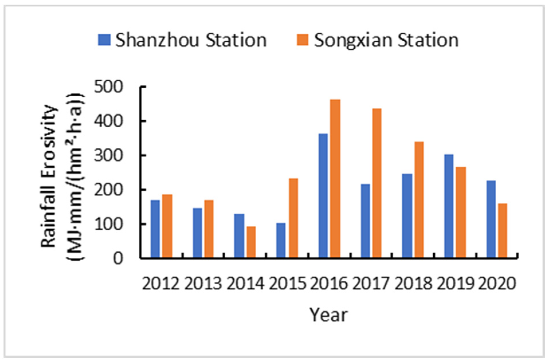
Figure 3.
Trend coefficient (r) variation of rainfall erosivity factor (R) in the Yellow River Basin.
Figure 3.
Trend coefficient (r) variation of rainfall erosivity factor (R) in the Yellow River Basin.

Figure 4.
Annual variation in soil erodibility factor.
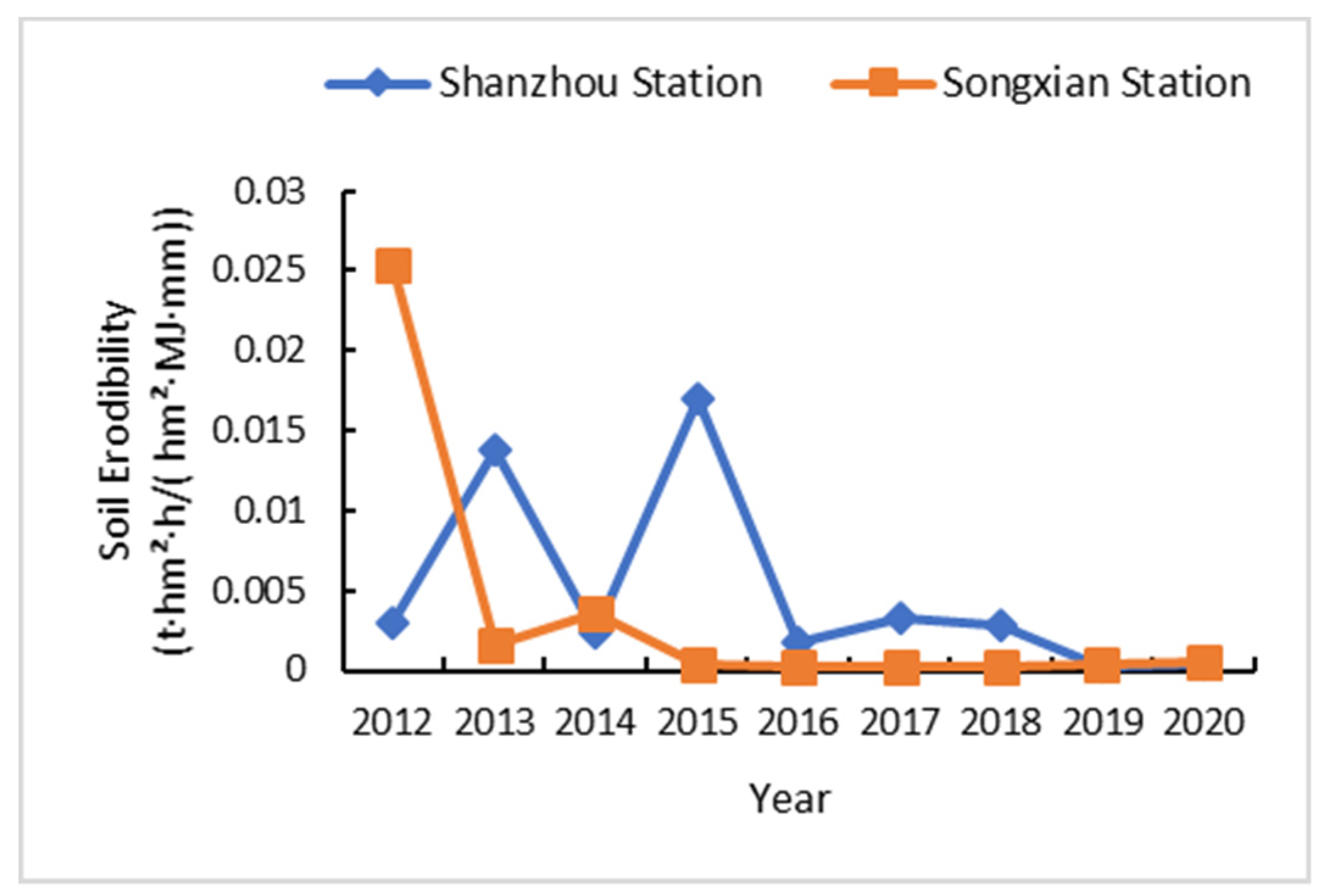

Table 1.
Results of terrain factor calculations.
| Monitoring Stations | Slope(°) | Slope Length(m) | S | L | LS |
|---|---|---|---|---|---|
| Shanzhou Station | 10 | 20 | 2.417 | 0.951 | 2.299 |
| 15 | 20 | 4.711 | 0.951 | 4.480 | |
| 25 | 20 | 8.300 | 0.951 | 7.893 | |
| Songxian Station | 10 | 20 | 2.417 | 0.951 | 2.299 |
| 15 | 20 | 4.711 | 0.951 | 4.480 | |
| 25 | 20 | 8.300 | 0.951 | 7.893 |
Table 2.
Results of vegetation cover factor calculations.
| Monitoring Stations | Runoff plot Number | Vegetation Type | Vegetation Coverage | C Value |
|---|---|---|---|---|
| Shanzhou Station | 1 | natural vegetation | 0.8678 | 0.4432 |
| 2 | bare ground | 0.2063 | 0.4484 | |
| 3 | mung bean、sweet potato | 0.5305 | 0.4458 | |
| 4 | sweet potato、mung bean | 0.4822 | 0.4462 | |
| 5 | natural vegetation | 0.8607 | 0.4432 | |
| 6 | bare ground | 0.2088 | 0.4484 | |
| 7 | mung bean、sweet potato | 0.4873 | 0.4462 | |
| 8 | sweet potato、mung bean | 0.4492 | 0.4465 | |
| 9 | natural vegetation | 0.8385 | 0.4434 | |
| 10 | bare ground | 0.2063 | 0.4484 | |
| 11 | alfalfa | 0.5040 | 0.4460 | |
| 12 | bramble | 0.8355 | 0.4434 | |
| Songxian Station | 1 | soya bean、corn、peanut、sweet potato | 0.6158 | 0.4452 |
| 2 | bare ground | 0.0170 | 0.4499 | |
| 3 | sweet potato、thuja、apricot | 0.5591 | 0.4456 | |
| 4 | natural vegetation | 0.8469 | 0.4433 | |
| 5 | soya bean、corn、peanut、sweet potato | 0.6082 | 0.4452 | |
| 6 | bare ground | 0.0444 | 0.4497 | |
| 7 | sweet potato、thuja、apricot | 0.5945 | 0.4453 | |
| 8 | natural vegetation | 0.8457 | 0.4434 | |
| 9 | soya bean、corn、peanut、sweet potato | 0.6139 | 0.4452 | |
| 10 | bare ground | 0.0157 | 0.4499 | |
| 11 | sweet potato、thuja、apricot | 0.5612 | 0.4456 | |
| 12 | natural vegetation | 0.8371 | 0.4434 |
Table 3.
Calculation results of soil and water conservation measures factor.
| Monitoring Stations | Runoff Plot Number | Soil and Water Conservation Measures | P Value |
|---|---|---|---|
| Shanzhou Station | 1 | natural vegetation (weeds) | 0.0142 |
| 2 | none (bare ground) | 1.0000 | |
| 3 | contour tillage (sweet potato) | 0.1036 | |
| 4 | contour tillage (green beans) | 0.3006 | |
| 5 | natural vegetation (weeds) | 0.0198 | |
| 6 | none (bare ground) | 1.0000 | |
| 7 | contour tillage (sweet potato) | 0.3829 | |
| 8 | contour tillage (green beans) | 0.4593 | |
| 9 | natural vegetation (weeds) | 0.0170 | |
| 10 | none (bare ground) | 1.0000 | |
| 11 | plant measures ( alfalfa ) | 0.1526 | |
| 12 | plant measures (wattle) | 0.0130 | |
| Songxian Station | 1 | agricultural land (none) | 0.3605 |
| 2 | bare ground (none) | 1.0000 | |
| 3 | plant measures (apricot trees) | 0.1867 | |
| 4 | natural vegetation (weeds) | 0.0331 | |
| 5 | agricultural land (none) | 0.4454 | |
| 6 | bare ground (none) | 1.0000 | |
| 7 | plant measures (apricot trees) | 0.2121 | |
| 8 | natural vegetation (weeds) | 0.0434 | |
| 9 | agricultural land (none) | 0.5251 | |
| 10 | bare ground (none) | 1.0000 | |
| 11 | plant measures (apricot trees) | 0.2036 | |
| 12 | natural vegetation (weeds) | 0.0523 |
Disclaimer/Publisher’s Note: The statements, opinions and data contained in all publications are solely those of the individual author(s) and contributor(s) and not of MDPI and/or the editor(s). MDPI and/or the editor(s) disclaim responsibility for any injury to people or property resulting from any ideas, methods, instructions or products referred to in the content. |
© 2023 by the authors. Licensee MDPI, Basel, Switzerland. This article is an open access article distributed under the terms and conditions of the Creative Commons Attribution (CC BY) license (http://creativecommons.org/licenses/by/4.0/).
Copyright: This open access article is published under a Creative Commons CC BY 4.0 license, which permit the free download, distribution, and reuse, provided that the author and preprint are cited in any reuse.


