
Submitted:
12 June 2023
Posted:
12 June 2023
You are already at the latest version
Abstract
Influenced by the quasi-stationary Mei-yu front and the development of mesoscale low vortices on the Mei-yu front, a torrential rain event occurred in Suzhou on July 6, 2020. The 24-hour rainfall recorded by the automatic station exceeded 200 millimeters, with the highest hourly intensity surpassing 70 millimeters, accompanied by thunderstorms and strong winds. This heavy precipitation process was characterized by suddenness, extremity, long duration, high precipitation efficiency, and backward propagation. Using various data sources such as the European ERA5 reanalysis data, ground-based automatic stations, sounding, Doppler weather radar, and wind profile radar, this paper analyzed in detail the circulation characteristics and radar echo structures of this torrential rain event, and further studied the triggering, feature evolution, and maintenance mechanisms of the heavy precipitation.The results show: (1) The continuously strengthening low-level jet stream propagates downward forming an ultra-low-level jet stream. Heavy precipitation is located on the left front side of the jet exit area, where strong convergence and lifting in the boundary layer overlap with the ascending branch of the secondary circulation above the shear line, resulting in heavy precipitation. (2) A supercell storm with intense precipitation produced this heavy rainfall event, characterized by a low centroid of strong echo; echo-free vault, bounded weak echo region, and other supercell structural features. During this event, the high reflectivity factor areas corresponded to high KDP value areas, indicating a large amount of liquid water content. Vertically, the KDP column can track the rainwater mixing ratio well, and its location corresponds to the vicinity of the short-term heavy precipitation occurrence. The high KDP value area mainly consists of numerous precipitation particles, and the vertical vortex wind field structure causes rapid growth of precipitation particles through continuous rolling. Furthermore, it can be found through correlation coefficients (CC) that there are always high-value areas for CC since they correspond to areas of intense precipitation. (3) Continuous triggering of mesoscale convective cloud clusters on the east-west ground convergence line leads to new development and forms a "train effect." Strong frontogenesis in both horizontal and vertical directions triggers and sustains this heavy precipitation event. The significant increase in liquid water and water vapor density has indicative significance for the occurrence of heavy precipitation.
Keywords:
Mei-yu front
; train effect
; convergence line
; frontogenesis function
1. Introduction
The major summer precipitation in East China comes from the Mei-yu rainfall in the Yangtze-Huaihe region, which often causes significant losses to life and property due to flood disasters (Ding Yihui et al., 2007; Wang Run et al., 1999). Mei-Yu precipitation is mainly contributed by convective precipitation (Fu Y and Liu G, 2003). Numerous studies have been conducted on the close relationship between the Mei-Yu belt and Jianghuai shear line in the Yangtze River Basin and the corresponding Mei-Yu front rainstorm process (Tao Shiyuan, 1980; Ding Yihui, 1993; Zhang Renhe and Liu Yimin, 2013; Tan Zheming and Zhao Sixiong, 2013; Zhang and Zhao, 2004; Sun Jianhua et al., 2004; Qian Yongfu et al., 2007; He Jinhai et al., 2008; Yao et al., 2008). In the context of accelerating global warming, extreme weather events have significantly increased in recent years, as has extreme heavy precipitation during the Mei-Yu season in the Yangtze River Basin (Liu Mingli et al., 2006). Studies on physical quantities characterizing energy, thermodynamics, and vertical wind shear conditions found that water vapor content in the atmosphere of different types of short-term heavy precipitation environments is an important factor determining the intensity of heavy precipitation, while environmental condition differences are not significant (Tian Fuyou, 2017). An extremely heavy rainfall event in July 2016 in Hubei Province, on the southern side of the Mei-Yu front, had strong extremity mainly due to its extreme water vapor conditions (Zhao Xianting, 2020). On May 7, 2017, Guangzhou experienced a sudden local extremely heavy rain event, mainly due to the warm cloud precipitation-dominated convective system generating weak cold pools that drove continuous propagation of the convective system, resulting in an enlarged strong precipitation echo area and extreme hourly rainfall intensity under the influence of small-scale terrain. The movement direction of the MESO-scale convective system's cell was almost opposite to its propagation direction, leading to very slow system movement, obvious backward propagation, and ultimately long-lasting heavy precipitation (Xu Jun, 2018). Rainfall is one of the important sources of water in ecosystems, and forests are the main body of the terrestrial ecosystem. The study found that the rainfall is intercepted by the forest canopy, which reduces the impact of raindrops on the surface with less soil erosion. The excess rainfall enters the forest ecosystem and participates in the hydrological cycle process of the whole ecosystem. It can synchronously dissolve the atmospheric settling matter and forest secreted matter into the forest ecosystem, so as to realize the supplement of nutrients and mineral elements in the forest ecosystem. In addition, heavy rainfall events in Taihu Lake basin often bring soil erosion, runoff can carry a large number of suspended solids, nutrients, heavy metals and organic pollutants in basin and surrounding cities into Taihu Lake, increasing soil erosion and high turbidity water input. Then it will increase nitrogen and phosphorus pollution into the lake load, easy to induce cyanobacteria bloom in Taihu Lake, therefore, it will negatively affect the lake ecosystem structure and service function (Yibo Zhang, 2020; Miao Liu, 2020).
Although research on heavy precipitation during the Mei-Yu season has been relatively extensive, the localized characteristics and causes of rainstorms and weather systems in East China remain complex. The formation and maintenance mechanism of the Mei-Yu front is influenced by various factors, and its generation, evolution mechanisms, and causes still need further in-depth study; extremely heavy rainstorm usually involves interaction among different systems at mid and low latitudes as well as between different scales, which requires comprehensive attention to issues and broader research perspectives. During the 2020 Mei-Yu season, a large-scale heavy rainfall event occurred in the middle and lower reaches of the Yangtze River, causing water levels in multiple watersheds to approach or exceed historical highs, posing a huge threat to the water environment and ecological security of the watershed. This paper studies the cause of this heavy rainstorm by analyzing in detail the evolution characteristics of echo, circulation background, physical quantity characteristics, boundary layer environment, ground convergence conditions, Mei-Yu frontogenesis conditions and the evolution of low-level jet during the process of a quasi-stationary Mei-Yu front and the development of MESO-scale vortex on the Mei-Yu front in Suzhou on July 6, 2020. The analysis results will help deepen the understanding of the occurrence and development mechanism of the Mei-Yu front heavy rainfall process, provide reference for the prediction and early warning of extreme rainfall in the Yangtze Huaihe River during the Mei-Yu period in East China in the future, and provide decision-making reference for scientific response and management of the secondary environmental risks that may be caused by rainstorm and flood in the Taihu Lake basin.
2. Data and methods
2.1. Data
The data used in this article include: (1) The 5th generation global atmospheric reanalysis data ERA5 (ECMWF reanalysis v5) reanalysis data released by the European Center for Medium Range Numerical Forecasting (ECMWF), with a spatial resolution of 0.1 ° × 0.1 °, with a time resolution of 1 hour; (2) On July 6, 2020, from 00:00 to 12:00, the minute precipitation, temperature, and 2-minute average wind direction and wind speed of automatic stations within the Suzhou area (Figure 1); (3) Changzhou Doppler weather radar data from 00:00 to 12:00 on July 6, 2020; (4) Taicang wind profile data from 00:00 to 12:00 on July 6, 2020; (5) Kunshan microwave radiometer Data at 00:00-12:00 on July 6, 2020.
2.2. Method
Using GRADS and PYTHON mapping software, Micaps4.0 system and MESO-scale analysis tools, the synoptic method and MESO-scale analysis technology are used to analyze the weather system, dynamic conditions, frontogenesis conditions and energy condition that caused the heavy rainstorm process.
3. Result and Analysis
3.1. Precipitation distribution and evolution of radar echo structures
3.1.1. Precipitation distribution
Heavy precipitation occurred in the central and southern parts of Suzhou affected by the quasi-stationary plum rain front and the development of mesoscale low vortices on the front from the early morning to morning of July 6, 2020. According to the statistics of rainfall from 20:00 on the 5th to 20:00 on the 6th, except for Zhangjiagang, all six national meteorological stations in Suzhou experienced heavy rain to torrential rain, with the Suzhou station registering the highest accumulated rainfall of 181.4 mm. The maximum accumulated rainfall at an automatic station was 202.6 mm, which occurred at Huangdai Town in Xiangcheng District. Influenced by strong convective cloud clusters on the morning of the 6th, multiple stations in Suzhou experienced short-term heavy precipitation, with a total of 102 automatic stations across the city recording hourly rainfall intensity exceeding 20 mm, 16 of which exceeded 50 mm. The maximum hourly rainfall intensity of 72.5 mm appeared in Yushan Town of Kunshan (9-10 am), accompanied by thunderstorms and gales of level 7-9, and locally reaching level 10 or higher. This heavy precipitation event had sudden and extreme characteristics, causing some townships in Suzhou to be affected by disasters.
This heavy precipitation exhibited characteristics such as rearward propagation, long duration, and high precipitation efficiency. The initial convection was first triggered near Xiangcheng in Suzhou at around 02:00 on the 6th (Figure 2a). Before 05:00, the convective echo remained relatively stable and continued to produce rainfall near its initial location in Xiangcheng. New convective cells were continuously generated near the initial convection, moving slowly towards the northeast and forming mixed precipitation echoes of cumulus and strati form clouds. The newly formed convective echoes continuously propagated rearward, leading to organized convection. From 06:00 to 08:00, the convective system further developed, gradually forming a convective cloud cluster centered near Xiangcheng. The rainfall data from Suzhou station (station number 58349) (Figure 1b) showed that the rainfall intensity rapidly increased within a short period after the onset of precipitation. The station recorded 18 consecutive 5-minute rainfalls exceeding 2 mm, with the highest reaching 17.1 mm, and the maximum hourly rainfall intensity (41.3 mm) occurred between 08:00 and 09:00.
After 08:00, new convective cells continuously formed on the northern side of the initial convection in Xiangcheng and persisted in moving toward the northeast. New convective cells gradually moved eastward with the main body of the convective rain belt, while upstream convective systems constantly stimulated new cells to merge and strengthen with existing cells, producing rearward propagation and a "train effect" where convective cells repeatedly passed through the same location, resulting in short-term heavy precipitation. Convection development was most rapid and intense during this stage, forming a vortex-like pattern moving towards the northeast. The Jiangxiang station in Kunshan (station number M5956) recorded 25 consecutive 5-minute rainfalls exceeding 5 mm (Figure 2b), and the maximum hourly rainfall of 72.5 mm occurred at 09:00. The Taicang Liuhe station recorded 14 consecutive 5-minute rainfalls exceeding 2 mm, with the maximum hourly rainfall reaching 38.4 mm (image omitted).
3.1.2. Radar Echo Structure Evolution Process
The development process of this MESO-scale convective rain band is analyzed through Changzhou radar, to further examine the causes of the extreme heavy precipitation and its persistence. The evolution of the strong precipitation radar echoes mainly consists of the convective initiation stage (02:00-05:00), convective development stage (05:00-08:00), and convective rainband propagation stage (08:00-10:00). Before 02:00 on the morning of the 6th, precipitation echoes began to form near Xiangcheng, Suzhou. In the first hour (02:00-03:00), the newborn precipitation echoes remained quasi-stationary near Xiangcheng, causing continuous precipitation but with low intensity, with hourly precipitation below 10mm, dominated by strati form clouds. From 03:00 onwards, the intensity of the initial echoes increased, continuously stimulating new convective cells in the vicinity. These cells developed and moved downstream, forming a layered, accumulated mixed block echo. During the downstream migration of the convective cells, backward propagation also occurred; from 05:00-08:00, convective cells continued to develop, gradually evolving into a cyclonic convective cloud cluster near Kunshan (Figure 3a).
From 8:24 to 8:30, the cyclonic convective cloud cluster expanded, with an increasing range of strong echo centers and intensities exceeding 55 dBz. Strati form cloud echoes near the rear of the convective cloud cluster in Wuxi gradually organized into a band. At 08:42, the cyclonic convective cloud cluster continued to strengthen and move eastward, with a central intensity over 60 dBz, a top height exceeding 14 km, and the emergence of distinct positive-negative velocity pairs on the 0.5° elevation angle radial velocity map. The rotational speed reached 11 m•s-1, indicating the presence of a mesocyclone. The broad cyclonic echo suggests that heavy precipitation was wrapped around the mesocyclone, which is a super cell storm with intense rainfall, corresponding to the extreme short-term precipitation of 17.1 mm in 5 minutes at Suzhou station. Convective cells were stimulated on the original banded echo near Wuxi, while the structure of the banded echo gradually became denser. From 08:48-08:54, the echo top height exceeded 15 km, and the strongest central intensity remained above 60 dBz. The vertical cross-section shows that the height of convective echoes exceeding 40 dBz is all below 6 km, with a low centroid for strong echoes. The strong echo nucleus shifts to the right with increasing altitude, with a gap in the front indicating strong inflow air entering the updraft. A distinct rear V-notch can be seen at elevation angles of 1.5-3.3°, and it's less evident below 1.5°, indicating strong downdrafts. Strong precipitation occurred when the high reflection factor region corresponded to the high Kdp value area, indicating a large amount of liquid water content. The Kdp high-value area mainly consists of a large number of precipitation particles. The vertical vortex wind field structure makes the precipitation particles grow rapidly as they roll up and down, leading to the highest hourly rainfall intensity in Suzhou from 08:00-09:00. The positive-negative velocity pair persisted, but the rotational speed decreased slightly. At 09:00, the overall echoes formed an inverted "L"-shaped bow shape, with the north-south echo band moving eastward from the Yangcheng Lake area in Kunshan, and the central intensity exceeding 55 dBz, corresponding to the beginning of short-term heavy precipitation near the eastern part of Suzhou in Taicang. At this time, the echo top height was lower than before. The eastward-moving east-west echo band intensified, and new convective cells were continuously born at the tail. At 09:06, the tail-end convective cells began to merge, rapidly increasing in strength, and the positive-negative velocity pairs disappeared. At 9:12, the east-west banded echo began to exhibit a train effect and continued to propagate eastward with persistent intensity, resulting in short-term heavy precipitation exceeding 30 mm/hour from 09:00-10:00 in Suzhou. At 9:30, the strong north-south banded echo began to break, and at 9:36, the inverted "L"-shaped bow-shaped echo completely split into northern block and southern banded echoes. The banded echoes extended southward, with the eastward movement still dominating. At 9:42, the main body of the echo began to weaken, and the direction of movement gradually changed from eastward to southeastward. At 9:54, the strong echo at the front of the banded echo moved into Shanghai, and the echo intensity within Suzhou significantly weakened, with the organizational structure starting to loosen. After 10:00, the precipitation intensity in the western part of Suzhou decreased rapidly, while eastern areas like Kunshan still experienced precipitation rates close to 20 mm/hour (Figures 3b-d).
3.2. Triggering and Maintenance Mechanism Analysis
Another necessary condition for short-term heavy rainfall is the persistence of a strong precipitation system in a certain area. In this heavy rain event, an ultra-low-level jet existed and strengthened during the night, continuously transporting warm and moist air and energy to Suzhou, sustaining the rainfall for an extended period. We will discuss the mechanisms that allowed the precipitation system to persist from the perspectives of boundary layer environment, frontogenesis, and wind profile radar before the occurrence of heavy precipitation.
3.2.1. Circulation Field Analysis
From the night of July 5th to the daytime of July 6th, 2020, an upper-level trough at 500-700 hPa from the mid-latitudes moved eastward, and the Northwest Pacific subtropical high (hereafter referred to as "sub-high") exhibited a zonal distribution. The west ridge point was biased to the west, and the sub-high ridge line was located near 25°N. Southern Jiangsu was on the northwest edge of the sub-high periphery, with a continuous supply of southwest warm and moist air. The upper-level trough's northerly airflow merged with the southerly flow at the sub-high periphery over southern Jiangsu. At 850 hPa and 925 hPa, there were two cold shear lines extending northeast-southwest from eastern Jianghuai to southern Anhui. Suzhou was located on the south side of both the upper-level trough bottom and the low-level shear line, within the wind speed convergence zone at the top of the southwest jet axis, with good wind direction and wind speed convergence conditions. The convergence of cold and warm air in the middle and lower reaches of the Yangtze River formed a quasi-stationary front extending northeast-southwest on the ground. Suzhou was located on the north side of the eastern part of the quasi-stationary front. The synoptic-scale system configuration provided extremely favorable conditions for heavy to intense rainfall events (Figure 4a). From the sounding diagram of Shanghai Baoshan Station at 20:00 on July 5th (Figure 4b), a low-level jet of 20 m•s-1 appeared at 850-700 hPa, with the strongest southwest jet near 700 hPa, reaching a maximum wind speed of 24 m•s-1. The intensified mid-low level southwest jet led to an increase in humidity and thickness of the moist layer, with temperature and dew point curves very close, indicating near saturation throughout the atmosphere. On the other hand, it exacerbated atmospheric instability; Baoshan station had a CAPE value of 939.9 J, a K index of 35.8°C, a lifting condensation height near 1000 hPa, a 0°C layer height of 5.6 km, and a cloud base specific humidity of 20.0 g•kg-1, indicating the presence of a deep warm cloud layer with a large water content. A moderate CAPE value effectively prevents rapid passage of air masses with high low-level moisture content through the bottom of the warm cloud layer, reducing precipitation efficiency. The equilibrium height was measured at 214 hPa, favoring the development of convection to higher altitudes. The increasing southwest jet and strong convergence of wind direction and wind speed in the boundary layer placed Suzhou in an unstable warm and moist atmosphere conducive to upward motion. The weak wind force near the ground and the presence of strong vertical wind shear in both the lower 0-1 km and middle 0-3 km layers were conducive to the organized development of convective systems. Suzhou's low lifting condensation height, moderate CAPE, and strong mid-low level vertical wind shear were all highly conducive to heavy precipitation.
3.2.2. Boundary Layer Environment Characteristics Analysis
Around the morning of July 6, 2020, there was a cold shear line at 850 hPa over southern Jiangsu along the Yangtze River. Suzhou was located at the junction of southwest and southeast airflow on the ground. Near the ground, CIN was 0, the cloud base was low, and the LCL was close to the ground, while the LFC was relatively low, which was highly favorable for the initiation of initial convection.
Vertical wind field characteristics near the shear line showed (Figure 5a) that there was a distinct secondary circulation cell above the cold shear's northern side at 850 hPa. This circulation cell was a direct thermal circulation cell, and a weak indirect thermal circulation cell existed on the south side of the cold shear. The ascending motion was mainly located between the two circulation cells with opposing directions, with the most intense ascending motion near the shear line. There was a southerly component in the ascending motion from 850 hPa to 500 hPa, indicating that the updraft was primarily composed of southerly winds. Ascending air currents below 850 hPa were relatively weak, and the ascending branch of the secondary circulation above the shear line was superimposed, favoring heavy precipitation. A high θse value belt extending northeast-southwest from the northwest side of the sub-high reached southern and central Jiangsu, with the center value exceeding 3605K. Heavy precipitation occurred near the θse front area, and the lower layer frontal slope (below 775 hPa) was steep, while from 775 hPa to 500 hPa, the frontal slope tilted with height. Below 600 hPa, θse displayed an unstable stratification with decreasing values with height, reflecting the baroclinic characteristics of the atmosphere (Figure 5b).
Below 700 hPa, positive relative vorticity was present near the shear line (Figure 5c), with relative vorticity tilting slightly northward with height, indicating weak baroclinicity. From 700 hPa to 400 hPa, there was a large value center of relative vorticity near Suzhou, with no obvious tilt with height, showing that the upper layer was dominated by quasi-geostrophic pressure and the lower layer had certain baroclinicity. The mid-low level positive vorticity area was a significant negative divergence area, indicating strong wind field convergence and even stronger convergence on the north side of the shear line.
During this event, significant moisture transport existed at both 850 hPa and 700 hPa, mainly originating from the Bay of Bengal. At 09:00, a strong moisture convergence center appeared in eastern Jiangsu along the southern part of the province, with a center value exceeding 120×10-5 kg-1•hPa-1•m-2•s-1, indicating significant moisture aggregation in the area and providing sufficient moisture conditions for heavy precipitation (Figure 5d).
3.2.3. Surface Convergence Line Analysis
At 08:00 on July 6, the wind field at Suzhou's ground level was relatively weak, with a weak convergence line formed near Yangcheng Lake and north of Wujiang. At this time, the main precipitation echo was located in the central-northern part of Suzhou, dominated by strati form precipitation, with a 5-minute rainfall not exceeding 4 mm. By 08:30, the wind field strengthened, forming an east-west convergence line from the northwest of Wujiang to the central part of Kunshan. At this time, multiple MESO-scale convective cloud clusters emerged and developed along the east-west precipitation echo belt, creating a train effect, which corresponded to the extreme heavy rainfall of 16 mm in 5 minutes at Suzhou Station. Around 09:00, cyclonic rotation appeared in the wind field near Xiangcheng, and the surface convergence line moved northward to a line connecting the northern part of Kunshan to the southern part of Taicang, corresponding to a significant increase in rainfall at Jiangxiang Village, Kunshan. Multiple 5-minute peak rainfall values occurred between 09:00-09:30; by 09:30, the convergence line further moved northward, its intensity weakened, and the rainfall intensity at Suzhou Station significantly decreased (Figure 6).
3.2.4. Maintenance and development of the Mei-Yu front
Precipitation intensity is closely related to the frontogenesis function, which mainly consists of vertical frontogenesis and horizontal frontogenesis. Here, we focus on the maintenance and evolution of the Mei-Yu front before and after the heavy precipitation event. The horizontal distribution of the 850hPa frontogenesis function reveals that at 07:00 on June 6th, the east-west horizontal frontogenesis zone is concentrated along the Jiangsu River to the central and northern parts of Southern Jiangsu. Simultaneously, the strengthening of the mid-high level cold advection promotes cold frontogenesis, superimposed on the low-level warm advection, significantly enhancing the atmospheric baroclinicity and generating heavy precipitation. In the next hour, the heavy precipitation area is located on the north side of the surface frontogenesis zone, well corresponding to the 850hPa frontogenesis zone. Vertically, around 7:00, the frontogenesis above 700hPa tilts northward with height, while the frontogenesis from 700hPa to the surface is almost vertical with the surface and weakens slightly below 925hPa. At 08:00, there is a strong frontogenesis zone above the surface, with the central intensity exceeding 4 × 10⁻⁹ K•m-1 •s-1, and the frontogenesis above the surface tilting northward uniformly with height, indicating an increase in baroclinicity. The strong frontogenesis in both horizontal and vertical directions in this process provides the energy and triggering conditions for the occurrence of heavy precipitation.
3.2.5. Evolution of Low-Level Jet Streams
During the heavy precipitation stage of this event, there was a deep low-level jet stream present at lower levels. The following text uses more refined wind profile radar data to analyze the evolution of the low-level jet stream. Starting from 08:00 on July 6th, before the heavy precipitation in Taicang, the entire layer was within a consistent southwesterly airflow, with sufficient moisture transport. Wind speeds below 1km gradually increased with height, and above 1.5km, they rapidly increased, forming a strong low-level jet stream. Between 2km and 4km, wind speeds exceeded 20m•s-1. Subsequently, the low-level jet stream began to propagate downwards, and at 8:20, an ultra-low-level jet stream with wind speeds exceeding 20 m•s-1 appeared at 1km. Around 8:48, wind speeds near 900 meters significantly increased, reaching 20 m•s-1, and continued to propagate towards the lower levels. At different heights and times, southwest jet streams formed multiple wind speed convergence zones of varying sizes, leading to vertical disturbances in the environmental wind field and the formation of unstable stratification, which corresponded to a significant increase in precipitation. By 9:00, the low-level jet stream further propagated downwards; at this time, the surface was dominated by southeasterly winds while above 700m there were southwesterly jet streams. The veering of wind direction with height indicated the strengthening of near-surface warm advection. Wind speeds between 1km and 2km exceeded 30 m•s-1, and both vertical wind direction and speed shear developed to their strongest between 0-1km. From 09:12 to 09:18, the low-level warm advection persisted, and at 900m, wind field disturbances began to appear. Between 720-900 meters, the wind direction reversed with height, indicating the intrusion of cold air. By 09:36, below 900m, southerly winds reversed to northwesterly winds, corresponding to the rapid increase in hourly precipitation of Taicang to a peak of 38.8 mm. The heavy rainfall was mainly located on the left-front side of the boundary layer jet exit region. Subsequently, at 9:54, the entire layer transitioned to northwesterly winds, and the precipitation rapidly weakened ((Figure 8).
3.2.6. Characteristics of Heavy Rainfall Process Revealed by Microwave radiometer Data
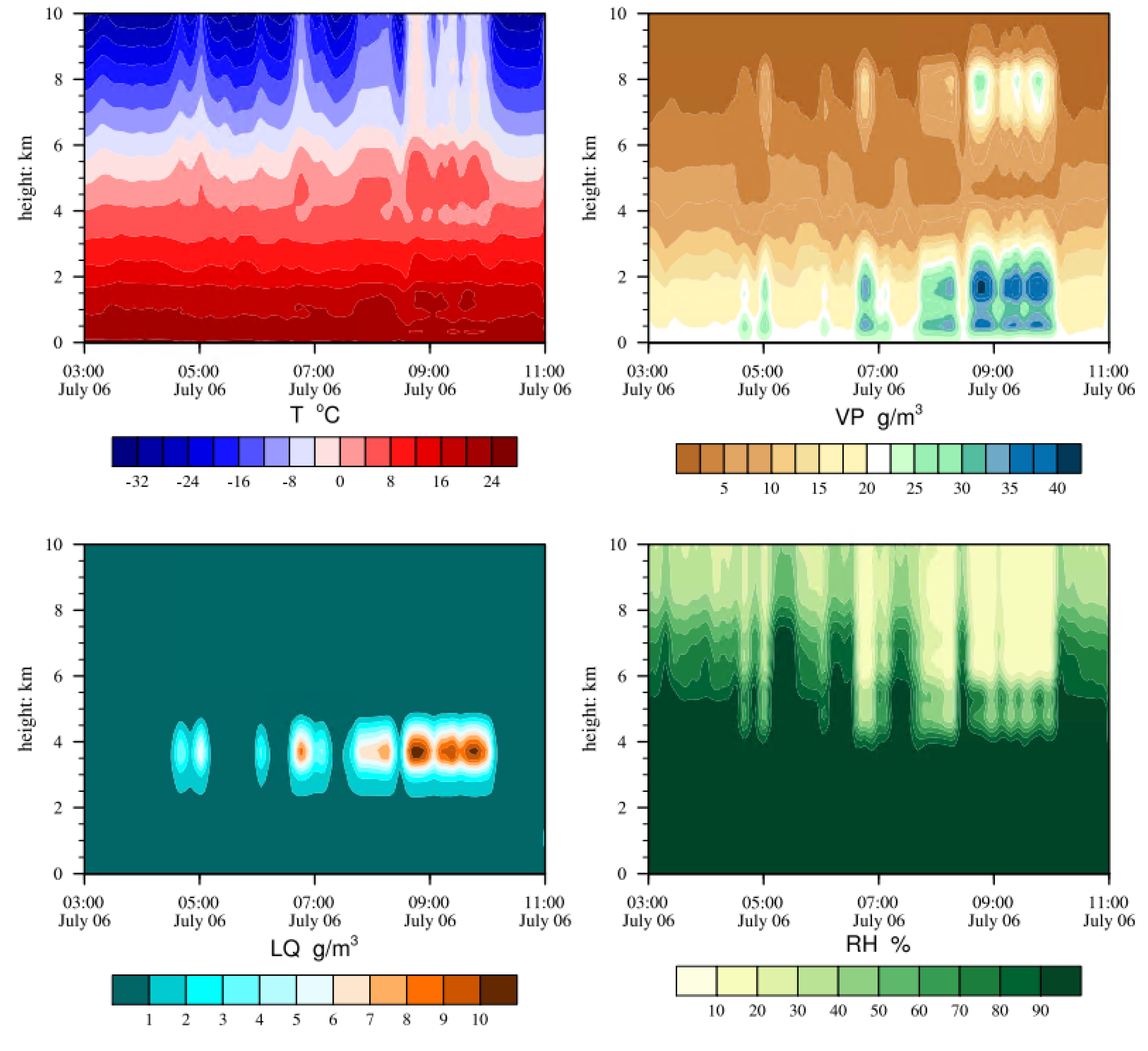
We further apply the data from the Kunshan microwave radiometer to analyze the evolution characteristics of this heavy precipitation event. In terms of temperature, from the early morning of the 6th until the end of the precipitation, a stationary front persisted over Suzhou. From 03:00 to 8:30, the atmosphere exhibited an unstable stratification with a warm and moist lower layer and a cold and dry upper layer. Between 8:30 and 10:00, the temperatures rapidly increased at heights of 8-10km, significantly weakening the unstable stratification. This indicates that the unstable energy was released as the short-term extreme heavy precipitation occurred.
Throughout the entire precipitation process, relative humidity was above 90% from 4000m height to the surface, indicating a very deep saturated layer. Between 3:00 and 5:00, there was a dry layer with relative humidity below 30% above 8000 meters; after 5:00, a brief infiltration of cold and dry air occurred, corresponding to the first peak in precipitation. Between 7:30 and 10:00, the lower boundary of the dry layer stabilized at 6000 meters. Particularly within one hour around 9:00, there was a significant increase in liquid water content between 3500-4500 meters altitude and water vapor density below 2000 meters. Especially between 8:30 and 9:00, the water vapor density exceeded 40g•cm-1, and liquid water exceeded 10 g•cm-1 at the center, corresponding to the second peak in precipitation. This suggests that microwave radiometer data have some indicative significance for the occurrence of heavy precipitation events (Figure 9).
4. Conclusion and Discussion
In this study, we used ERA5 reanalysis data, ground automatic stations, Doppler weather radar, and wind profile radar to comprehensively analyze a heavy rainstorm event that occurred in Suzhou on July 6, 2020. We investigated the triggering and maintenance mechanisms of intense precipitation. The results show:
- This event was influenced by a quasi-stationary Mei-yu front and the development of MESO-scale low vortices on the front, resulting in a heavy downpour in Suzhou along with short-term intense rainfall, localized thunderstorms, and strong convective weather. The precipitation process exhibited suddenness, extremity, long duration, and high precipitation efficiency.
- The evolution of strong precipitation echoes can be divided into three stages: the initiation of convection (02-05 hours), the development of convection (05-08 hours), and the propagation of convective rain bands (08-10 hours). The echo intensity at the peak precipitation period exceeded 60 dBz, with a top height of over 14 km. Broad spiral echoes indicated that intense precipitation enveloped mesocyclones, indicating the presence of super cell storms. The strong echo centroid was low, with vertical extension heights averaging below 6 km, representing a typical low-centroid warm region precipitation cloud cluster; features such as hanging echoes and bounded weak echo regions were observed during peak precipitation. High Kdp values corresponded to strong reflectivity areas, indicating huge liquid water content. The Kdp high-value areas were mainly composed of numerous precipitation particles, and the vertical vorticity characteristics of the wind field allowed precipitation particles to grow rapidly through continuous up-and-down rolling.
- The low lifting condensation level, high equilibrium level, deep moist layer, moderate CAPE, and strong low-to-mid-level vertical wind shear above Suzhou were all conducive to the occurrence of intense precipitation. The continuous strengthening of the low-level jet and its downward propagation formed an ultra-low-level jet, while strong wind direction and speed convergence within the boundary layer placed Suzhou in a warm and humid unstable atmosphere. Heavy rainfall primarily occurred on the left front side of the boundary layer jet exit region and secondary circulation's ascending branch above the shear line, which favored the development of heavy precipitation.
- Continuous triggering of MESO-scale convective cloud clusters on the ground east-west convergence line led to a train effect, along with strong frontogenesis both horizontally and vertically, providing energy and triggering conditions for intense precipitation. Throughout the entire precipitation process, the moist layer was extremely deep, with dry cold air infiltrating downward, significant jumps in liquid water and water vapor density, and two peak values corresponding to precipitation. Microwave radiometer data had some indicative significance for the occurrence of heavy rain.
The heavy rainfall process is easy to cause the increase of nutrients and pollutants in the lake and the full agitation of the sediment of the Taihu Lake, which is conducive to the large-scale growth of cyanobacteria bloom after the precipitation. Therefore, further in-depth research on the heavy rainfall process in the Taihu Lake basin in the future is conducive to providing decision-making reference for the secondary environmental risks caused by heavy rainfall in the Taihu Lake basin.
Author Contributions
Conceptualization and formal analysis, CAO Shuya; methodology, ZOU Lanjun; data curation, LI Yang and CHEN Bo; resources, MU Ruiqi; writing—original draft preparation, CAO Shuya; writing—review and editing, WU Yue; funding acquisition, CAO Shuya and ZOU Lanjun and CHEN Bo. All authors have read and agreed to the published version of the manuscript.
Funding
This research supported by the Key Projects of Jiangsu Provincial Meteorological Bureau KZ202108; Shanghai Yangtze River Delta Science and Technology Innovation Community Project 21002410200; 2020 Shanghai Science and Technology Innovation Action Plan: Social Development Science and Technology Research Project (Grant No.20dz1200703).
References
- DING YiHui, LIU JunJie, SUN Ying, et al, 2007. A Study of the Synoptic Climatology of the Mei-Yu System in East Asia[J].Chinese Journal ofAtmosphericSciences,31(6):1082-1101.
- WANG Run, JIANG Tong,GAO Junfeng, et al.1999.YANGTZE River Flood: Causes And Analysis[J].Journal of Natural Disasters,8(1):16-20.
- LIU Mingli, WANG Qianq.2006.Climatic characteristics of CHANG jiang HUAI he River Valley Extreme Precipitation in Mei-Yu Period[J].Journal of Nanjing Institute of Meteorology,29(5):676-681.
- Ding Yihui.1993.Research for the Jiang-Huai torrential rain in 1991[M].Beijing: China Meteorological Press, 257.
- He Jinhai,Zhao Ping, Zhu Congwen, et al.2008.Discussions on the East Asian subtropical monsoon[J]. Acta Meteor Sinica,66(5):683-696.
- Tan Zhemin, Zhao Sixiong.2013.Thestructure and mechanism of β MESO-scale strong convective system in south China [M].Beijing: China Meteorological Press,266.
- Zhang Renhe, LiuYimin.2013.The large-scale process of summer rain in southern China[M].Beijing: China Meteorological Press,312.
- MA Yin,CHEN Wen,WANG Lin.2011.A comparative study of the inter-annual Variation of summer rainfall anomalies between the Huaihe Mei-Yu season and the Jiangnan Mei-Yu season and their climate background. Acta Meteorologica Sinica, 69(2):334-343.
- Qian Yongfu, Wang Qianqian, Huang Danqing.2007.Studies of floods and droughts in the Yangtze-Huaihe River Basin[J].Chinese J AtmosSci,31( 6) :1279-1289.
- Sun Jianhua, Zhang Xiaoling, Qi Linlin,et al.2004.A study of vortex and its MESO-scale convective system during China heavy rainfall experiment and study in 2002[J]. Chinese J Atmos Sci, 28(5):675-691.
- ZHAO X T, WANG X F, WANG J, et al, 2020. Analysis of MESO-scale characteristics of torrential rainfall in Hubei Province during 18-20 July 2016[J].Meteor Mon,46(4);490-502(in Chinese).
- Zhonglin Yang, Kun Zhao. 2017. Microphysical Characteristics of Extreme Convective Precipitation over Yangtze-Huaihe River Basin during Meiyu Season using Polarimetric-Radar Data. Acta Meteorologica Sinica, 77(001):58-72.
- TIAN Fuyou, ZHENG Yongguang, ZHANG Tao et al. Characteristics of environmental parameters for multi-intensity short-duration heavy rainfalls over East China [J]. Torrential Rain and Disasters, 2017, 36(6): 518-526.
- ZHANG Xiaoling, LIN Jian, ZHANG Tao, et al. Overview of the Warm-Season Experiment in 2013.[J].Meteor Mon,41(5): 521-532.
- ZHU Geli, CAO Yanhua.2014.Numerical simulation of a rainstorm event over South China by using various cloud microphysics parameterization schemes in WRF model and its performance analysis [J]. Chinese Journal of Atmospheric Sciences (in Chinese), 38(3):513-523.
- Chen C,Hu Z Q, Hu S,et al.,2018.Preliminary analysis of data quality of Guangzhou s-band polar metric weather radar[J].J Trop Meteorol,34(1):59-67. (in Chinese). [CrossRef]
- Fu Y, Liu G. 2003. Precipitation characteristics in Mid-Latitude East Asia as observed by TRMM PR and TMI. Journal of the Meteorological Society of Japan, 81:1353-1369. [CrossRef]
- Chen B, Yang J, Pu J. 2013. Statistical Characteristics of Raindrop Size Distribution in the Mei-Yu Season Observed in Eastern China. Journal of the Meteorological Society of Japan, 91: 215-227.
- Wen J, Zhao K, Huang H, et al. 2017. Evolution of microphysical structure of a subtropical squall line observed by a polar metric radar and a disdrometer during OPACC in Eastern China. Journal of Geophysical Research Atmospheres, 122:8033-8050.
- Shusse Y, Nakagawa K, Takahashi N, et al. 2009. Characteristics of polar metric radar variables in three types of rainfalls in a Mei-Yu front event over the East China Sea. Journal of the Meteorological Society of Japan, 87: 865-875.
- Oue M, Uyeda H, Shusse Y. 2010. Two types of precipitation particle distribution in convective cells accompanying a Mei-Yu frontal rain band around Okinawa Island, Japan. Journal of Geophysical Research: Atmospheres, 115: 355-365.
- Oue, M, Uyeda H, Lee D. 2011. Raindrop size distribution parameters estimated from polar metric radar variables in convective cells around Okinawa Island during the Mei-Yu period. Asia-Pacific Journal of Atmospheric Sciences, 47:33-44.
- Xu, W, Zipser E J. 2015. Convective intensity, vertical precipitation structures, and microphysics of two contrasting convective regimes during the 2008 TiMREX. Journal of Geophysical Research: Atmospheres, 120:4000-4016. [CrossRef]
- Chang, W, Lee W, Liou Y. 2015. The kinematic and microphysical characteristics and associated precipitation efficiency of subtropical convection during SoWMEX/TiMREX. Monthly Weather Review, 143:317-340.
- Wang M, Zhao K, Xue M, et al. 2016. Precipitation microphysics characteristics of a Typhoon Matmo (2014) rain band after landfall over eastern China based on polar metric radar observations. Journal of Geophysical Research: Atmospheres, 121:12415-12433.
- Wen L, Zhao K, Zhang G, et al. 2016. Statistical characteristics of raindrop size distributions observed in East China during the Asian summer monsoon season using 2-D video disdrometer and Micro Rain Radar data. Journal of Geophysical Research Atmospheres, 2016, 121:2265-2282. [CrossRef]
- Luo Y, Wang H, Zhang R, et al. 2013. Comparison of Rainfall Characteristics and Convective Properties of Monsoon Precipitation Systems over South China and the Yangtze and Huai River Basin. Journal of Climate, 26:110-132. [CrossRef]
- Wen J, Zhao K, Huang H, et al. 2017. Evolution of microphysical structure of a subtropical squall line observed by a polar metric radar and a disdrometer during OPACC in Eastern China.
- Yibo Zhang, Kun Shi, Yunlin Zhang, et al. 2020. River plume monitoring in a deep valley reservoir using HJ-1 A/B images. Journal of Hydrology, 587. [CrossRef]
- Miao Liu, Yunlin Zhang, Kun Shi, et al. 2020. Effects of rainfall on thermal stratification and dissolved oxygen in a deep drinking water reservoir. Hydrological Processes. 34(15), 3387-3399. [CrossRef]
Figure 1.
Distribution of Suzhou automatic meteorological station.
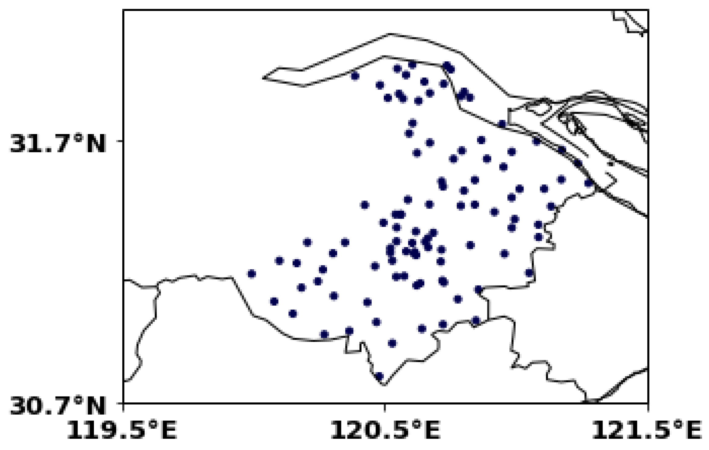
Figure 2.
Precipitation distribution of Suzhou from 20:00 5th July to 20:00 6th July(a); Precipitation per 5 minutes and per hour of M5956、M7241、58349 from 01:00 to 12:00 on 6th July.
Figure 2.
Precipitation distribution of Suzhou from 20:00 5th July to 20:00 6th July(a); Precipitation per 5 minutes and per hour of M5956、M7241、58349 from 01:00 to 12:00 on 6th July.
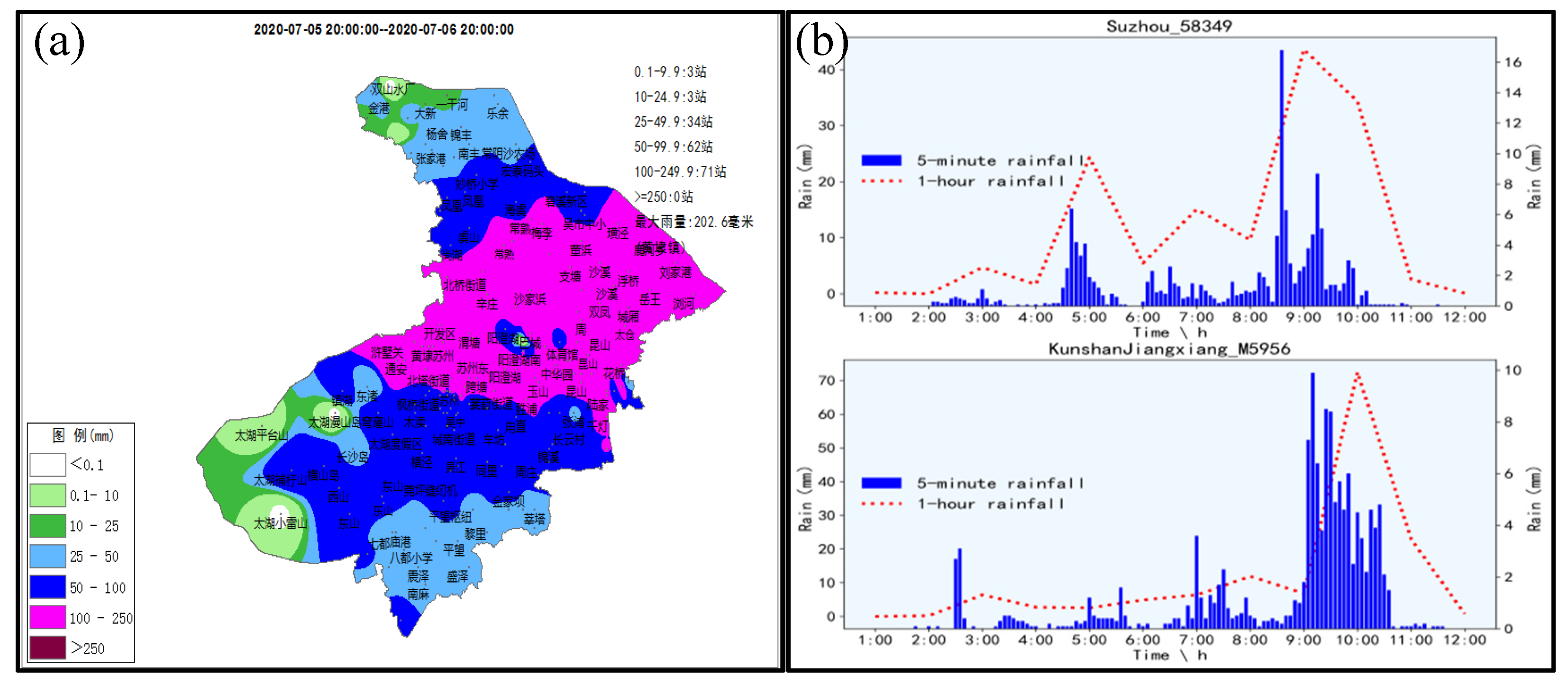
Figure 3.
0.5°composite reflectivity of 8:24(a);8:42(b);9:00(c);9:18(d) on the 6th July; Kdp at 8:54 (e); Echo top High at 8:54 (f);3D radar echo profile at 8:48 (g).
Figure 3.
0.5°composite reflectivity of 8:24(a);8:42(b);9:00(c);9:18(d) on the 6th July; Kdp at 8:54 (e); Echo top High at 8:54 (f);3D radar echo profile at 8:48 (g).
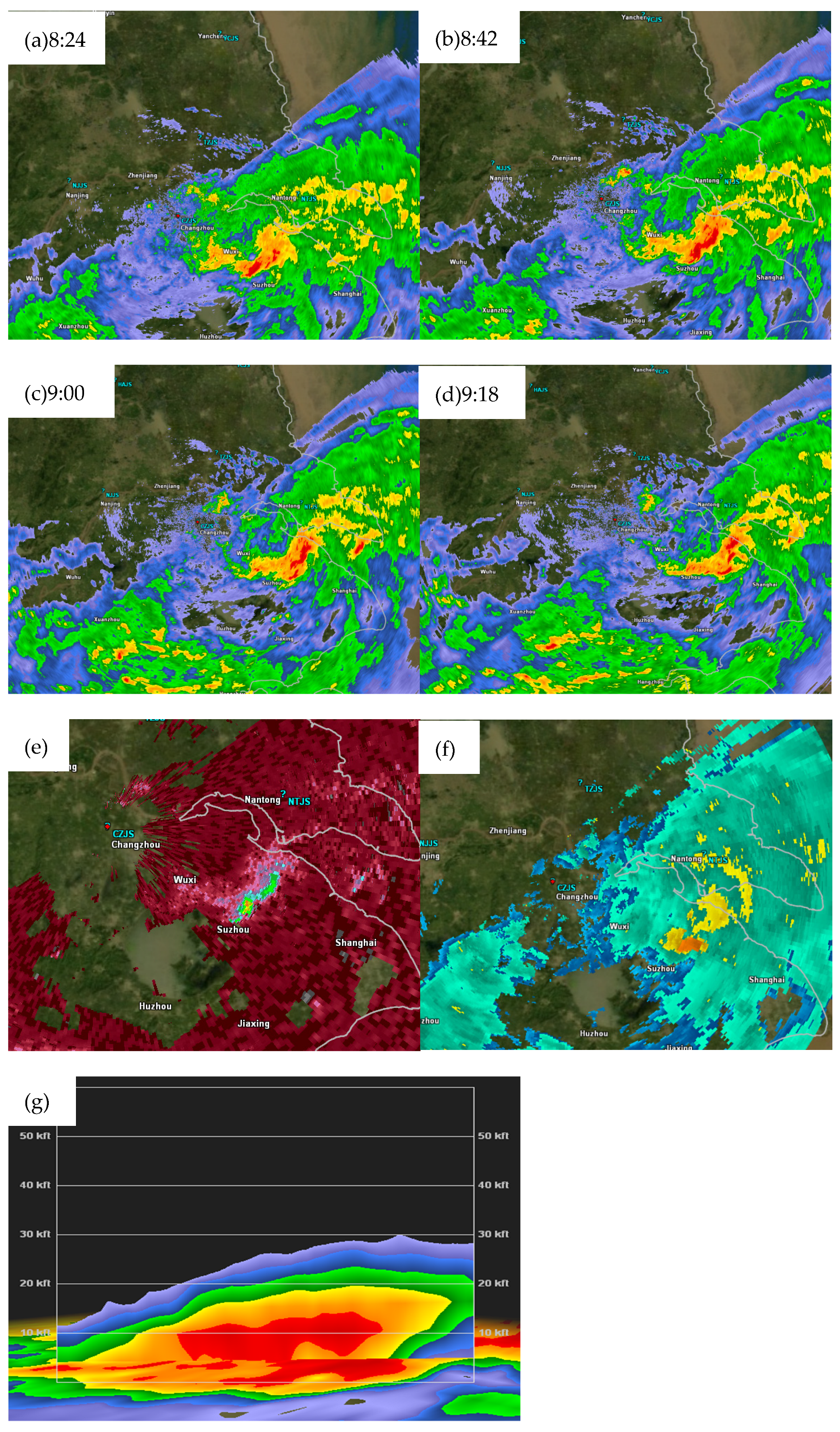
Figure 4.
MESO-scale composite analysis chart (a); Sounding map of BaoShan station at 20:00 on the 5th(b).
Figure 4.
MESO-scale composite analysis chart (a); Sounding map of BaoShan station at 20:00 on the 5th(b).
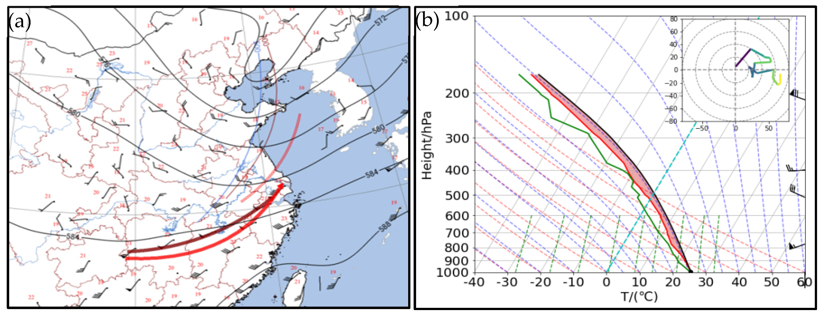
Figure 5.
vertical velocity time height profile along 120°E (a) the profile of pseudo equivalent potential temperature latitude altitude profile along 120°E(unit: K) (b) the profile of Vorticity and divergence along 120°E (c); the vapor flux and the water vapor flux divergence at 850hPa; (d) at 08:00 on the 6th July 2020 (arrowhead for vapor flux and shaded area for water vapor flux divergence, unit: ).
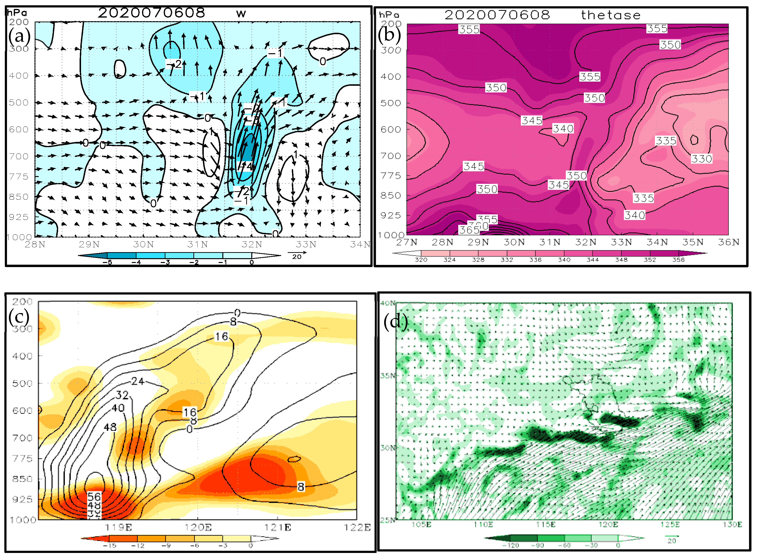
Figure 6.
Ground Automatic Station Wind Farm of Southern Suzhou at 8:00(a); 8:30(b); 9:00(c);9:30(d) on 6th(The blue shaded area is Taihu Lake).
Figure 6.
Ground Automatic Station Wind Farm of Southern Suzhou at 8:00(a); 8:30(b); 9:00(c);9:30(d) on 6th(The blue shaded area is Taihu Lake).
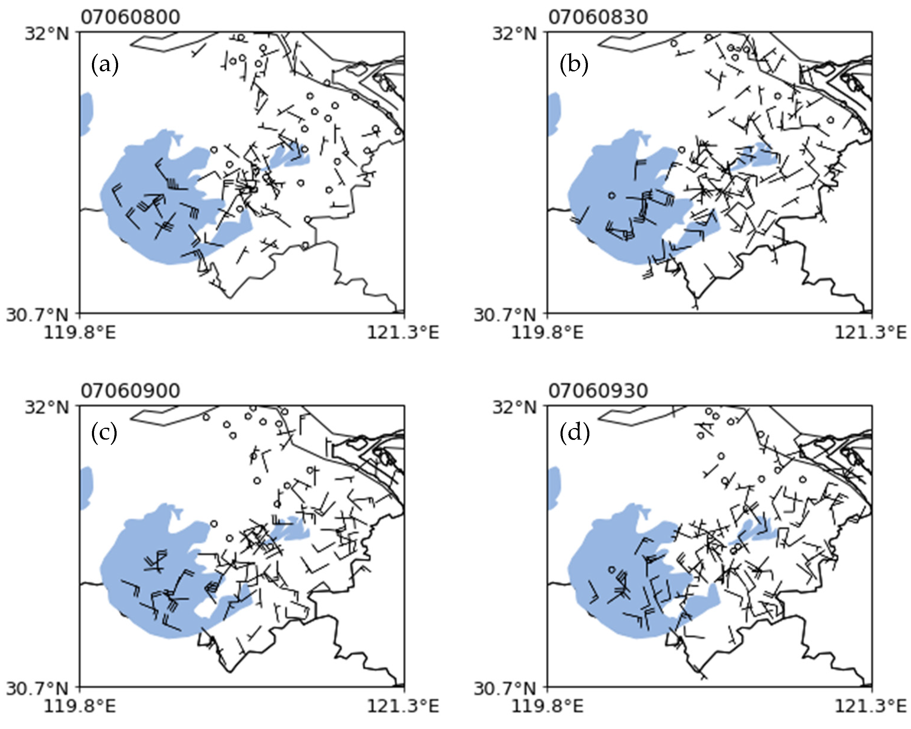
Figure 7.
Temperature distribution at 7:00(a)8:00(b)9:00(c)9:30(d)on the 6th; Horizontal frontogenesis function of 7:00(e)8:00(f)at 850hPa on July 6th; vertical frontogenesis function of 7:00(g)8:00(h)at 850hPa on July 6th.
Figure 7.
Temperature distribution at 7:00(a)8:00(b)9:00(c)9:30(d)on the 6th; Horizontal frontogenesis function of 7:00(e)8:00(f)at 850hPa on July 6th; vertical frontogenesis function of 7:00(g)8:00(h)at 850hPa on July 6th.
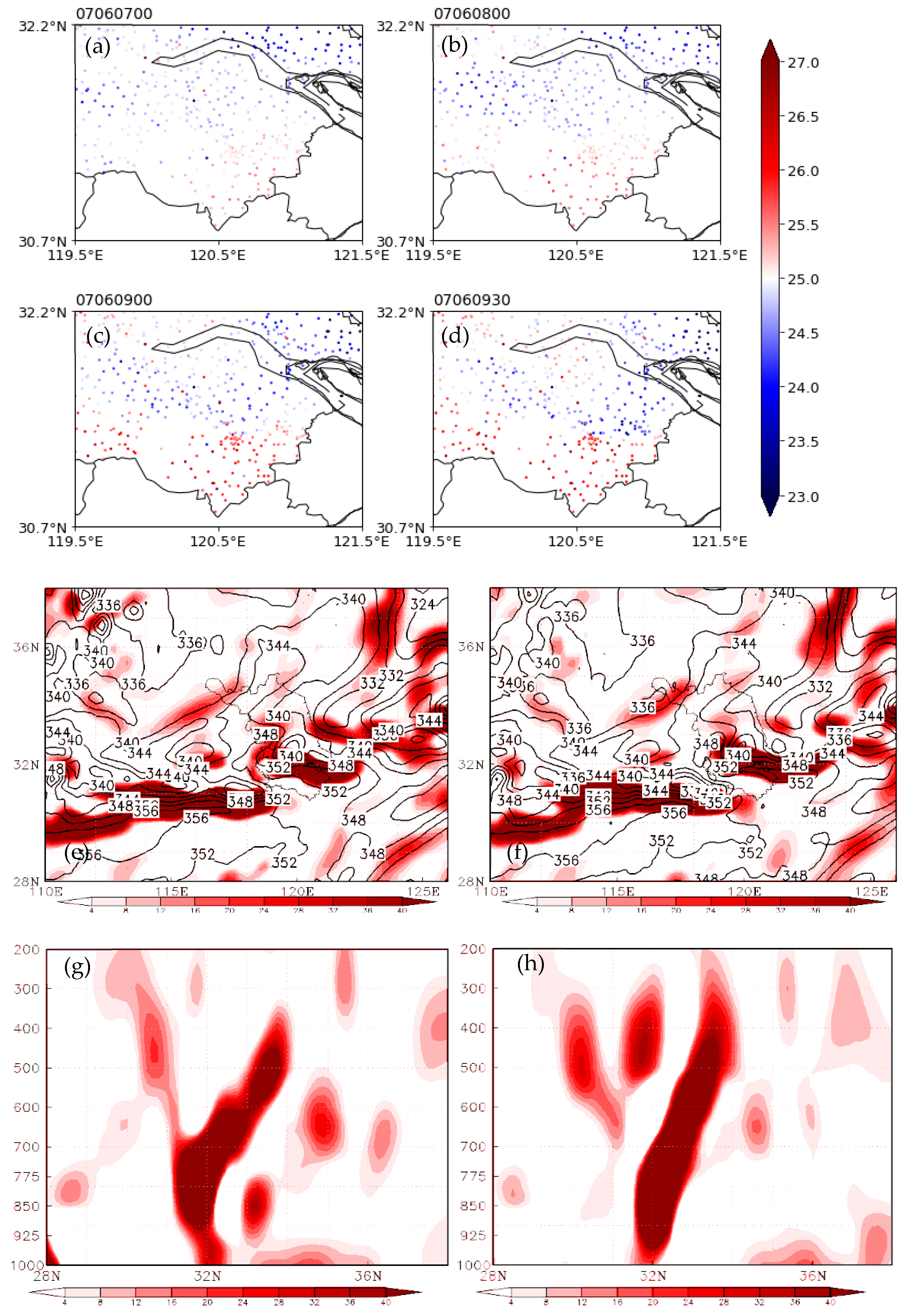
Figure 8.
Time altitude profile of horizontal wind field for wind profiler radar of TaiCang from 08:00-10:36 on July 6th.
Figure 8.
Time altitude profile of horizontal wind field for wind profiler radar of TaiCang from 08:00-10:36 on July 6th.
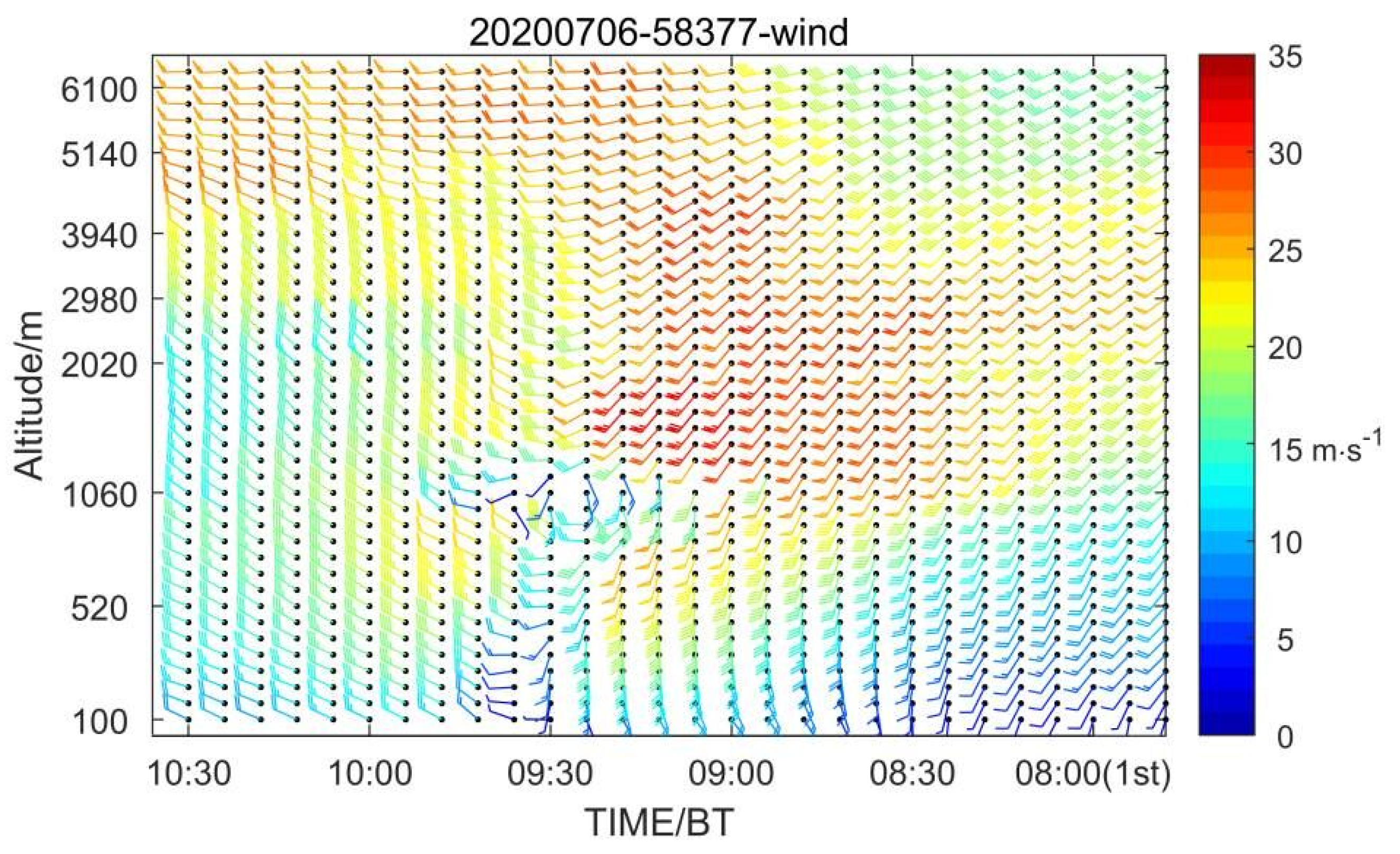
Figure 9.
Microwave radiometer temperature profile(a);Moisture density(b);Liquid water(c);relative humidity profile (d) at Kunshan Station at 3:00 to 11:00 am on the 6th.
Figure 9.
Microwave radiometer temperature profile(a);Moisture density(b);Liquid water(c);relative humidity profile (d) at Kunshan Station at 3:00 to 11:00 am on the 6th.
Disclaimer/Publisher’s Note: The statements, opinions and data contained in all publications are solely those of the individual author(s) and contributor(s) and not of MDPI and/or the editor(s). MDPI and/or the editor(s) disclaim responsibility for any injury to people or property resulting from any ideas, methods, instructions or products referred to in the content. |
© 2024 by the authors. Licensee MDPI, Basel, Switzerland. This article is an open access article distributed under the terms and conditions of the Creative Commons Attribution (CC BY) license (https://creativecommons.org/licenses/by/4.0/).
Copyright: This open access article is published under a Creative Commons CC BY 4.0 license, which permit the free download, distribution, and reuse, provided that the author and preprint are cited in any reuse.


