Submitted:
22 October 2020
Posted:
23 October 2020
You are already at the latest version
Abstract
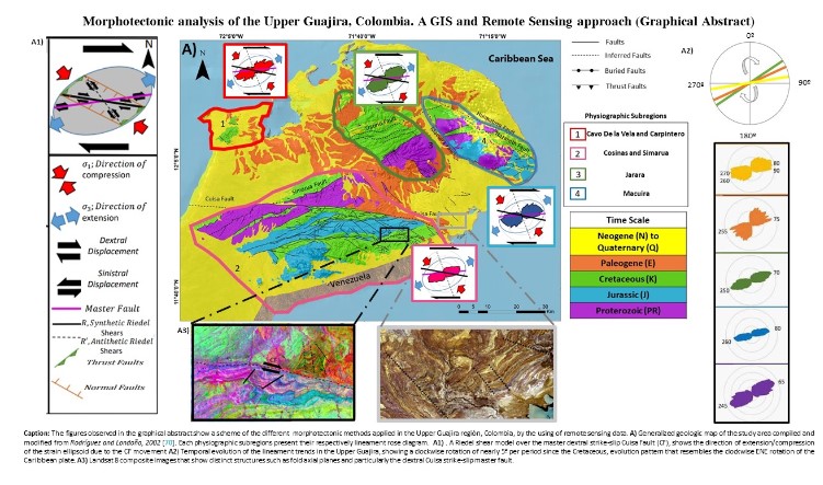
This study uses Landsat 8 and Digital Elevation Models (DEM) to show the dominant orientations of digital lineaments and morphotectonic features between measured trends and the tectonic evolution of the Upper Guajira, Colombia, in the northernmost region of the South American plate. Data from Landsat-8 and hillshaded images of three Digital Elevation Model (DEM) images with different resolutions (SRTM: 90m, ASTER-GDEM: 30m and Alos-Palsar: 12.5m), were used for the extraction and mapping of morpholineaments, drainage network and morphological features. Lineaments were analyzed by means of north azimuth frequency, length, density distributions, lithological distributions and geochronological periods. Tectonic control was supported by using the digitized geological map created by the Colombian Geological Service (SGC). Lineaments and faults were analyzed through the interpretation of a Riedel shear model as a result of the transtensional/transpressional tectonic arrangement of the Caribbean and South American plates. The directional trends of lineaments and faults indicate two dominant directions: NE-SW and E-W. The azimuth distribution analysis of measured structures and drainage channels show similar trends, except for some differences in the predominant directions of some drainage channels. The similarity in the orientation of lineaments, faults and drainage system highlights the degree of control exerted by underlying structures on the surface geomorphological features. Drainage channel classification illustrates the morphological and neo-tectonic complexity of the region. The extracted lineaments were divided into five geochronological groups based on the main ages of host rock formations according to the Colombian Geological Service (SGC) geological map. From the Cretaceous onward, the lineament azimuth frequency rotates from a NE-SW trend to a prominent E-W direction, which resembles the translation that Caribbean plate has been undergoing since the Cretaceous. Our results confirm that Remote Sensing techniques are reliable and useful to study the morphotectonic of an area and can be applied to zones of difficult access.
Keywords:
Remote sensing
; Morphotectonic analysis
; Lineaments
; Riedel shear model
; Upper Guajira
; Caribbean plate
Copyright: This open access article is published under a Creative Commons CC BY 4.0 license, which permit the free download, distribution, and reuse, provided that the author and preprint are cited in any reuse.


