Submitted:
09 January 2019
Posted:
10 January 2019
You are already at the latest version
Abstract
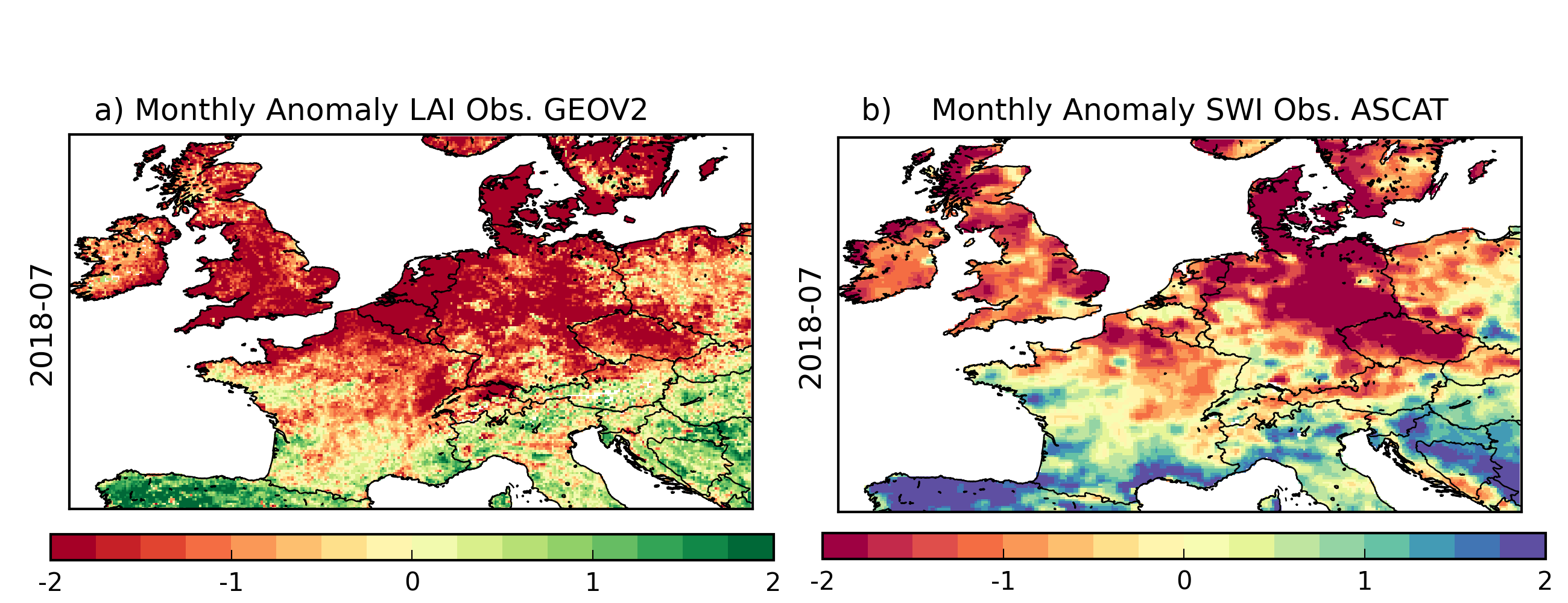
This study aims to assess the potential of the LDAS-Monde a land data assimilation system developed by Météo-France to monitor the impact of the 2018 summer heatwave over western Europe vegetation state. The LDAS-Monde is forced by the ECMWF’s (i) ERA5 reanalysis, and (ii) the Integrated Forecasting System High Resolution operational analysis (IFS-HRES), used in conjunction with the assimilation of Copernicus Global Land Service (CGLS) satellite derived products, namely the Surface Soil Moisture (SSM) and the Leaf Area Index (LAI). Analysis of long time series of satellite derived CGLS LAI (2000-2018) and SSM (2008-2018) highlights marked negative anomalies for July 2018 affecting large areas of North Western Europe and reflects the impact of the heatwave. Such large anomalies spreading over a large part of the considered domain have never been observed in the LAI product over this 18-yr period. The LDAS-Monde land surface reanalyses were produced at spatial resolutions of 0.25°x0.25° (January 2008 to October 2018) and 0.10°x0.10° (April 2016 to December 2018). Both configuration of the LDAS-Monde forced by either ERA5 or HRES capture well the vegetation state in general and for this specific event, with HRES configuration exhibiting better monitoring skills than ERA5 configuration. The consistency of ERA5 and IFS HRES driven simulations over the common period (April 2016 to October 2018) allowed to disentangle and appreciate the origin of improvements observed between the ERA5 and HRES. Another experiment, down-scaling ERA5 to HRES spatial resolutions, was performed. Results suggest that land surface spatial resolution is key (e.g. associated to a better representation of the land cover, topography) and using HRES forcing still enhance the skill. While there are advantages in using HRES, there is added value in down-scaling ERA5, which can provide consistent, long term, high resolution land reanalysis. If the improvement from LDAS-Monde analysis on control variables (soil moisture from layers 2 to 8 of the model representing the first meter of soil and LAI) from the assimilation of SSM and LAI was expected, other model variables benefit from the assimilation through biophysical processes and feedbacks in the model. Finally, we also found added value of initializing 8-day land surface HRES driven forecasts from LDAS-Monde analysis when compared with model only initial conditions.
Keywords:
land surface modelling
; data assimilation
; leaf area index
; surface soil moisture
; summer 2018
Copyright: This open access article is published under a Creative Commons CC BY 4.0 license, which permit the free download, distribution, and reuse, provided that the author and preprint are cited in any reuse.


