
Submitted:
26 May 2024
Posted:
27 May 2024
You are already at the latest version
Abstract
Artisanal and Small-scale Gold Mining (ASGM) has caused several environmental impacts, resulting in significant siltation of water bodies due to the deposition of sediments on river banks. Based on this perspective, this study aims to investigate the water bodies and regions most impacted by mining activities, especially in relation to the increase in the Total Suspended Solids (TSS) caused by ASGM, focusing on the territories of Suriname and French Guiana, over the period from 2017 to 2023, through the creation of an algorithm in Google Earth Engine. The research also aims to map and describe active mining in this region using the Classification and Regression Tree (CART) method, which achieved an overall accuracy of 82% and a kappa index of 0.77. The results reveal that from 2017 to 2024 there was an increase of 148.09 km² of mining, with an average increase in TSS of up to 167 mg/l in water bodies most affected by mining activities. Finally, the continued importance of using remote sensing technologies, such as GEE, together with innovative methodological approaches, to monitor and manage natural resources in a sustainable manner is highlighted.
Keywords:
mining
; total suspended solids
; environmental monitoring
; remote sensing
; google engine
; image classification
1. Introduction
The global gold mining industry generally focuses on large companies, but in many parts of the world, especially in developing countries, mineral extraction is predominantly driven by artisanal and small-scale mining (ASGM), forming a diverse and complex sector [1,2].
ASGM is a widespread practice in developing countries in the Americas, Asia and Africa [3,4,5]. In the Amazon, this activity began in the 1950s in areas known as mining and currently involves hundreds of thousands of people due to the increase in gold prices in recent years [6].
Despite its economic importance, ASGM (Figure 1) has caused several environmental impacts, including mercury contamination, sedimentation of waterways and environmental degradation [4,7]. This practice results in significant siltation of water bodies due to the deposition of sediments on river banks, where the exploitation of alluvial deposits is common [2]. This affects water quality, increasing the Total Suspended Solids (TSS) and reducing the penetration of sunlight necessary for the production of organic matter by aquatic organisms [8], in addition to impacting fish [9] and benthic communities [10].
River sedimentation is a globally recognized problem in gold mining regions such as Indonesia, Ghana, French Guiana and Peru, where most operations take place on riverbanks or directly in river beds [9]. This process significantly contributes to the increase in suspended solids in the water, damaging the quality and health of aquatic ecosystems. In the Brazilian Amazon, sediment resulting from mining can reach one or two tons per gram of gold produced [4], further intensifying this problem.
Furthermore, the accumulation of sediment in riverbeds can alter river channel morphology, affecting the availability of suitable habitats for various aquatic species, such as obstructing fish spawning areas and destroying important habitats such as sandbars. and rocky bottoms, essential for the life cycle of many species.
Another negative point of artisanal and small-scale mining (ASGM) in the Amazon is associated with socio-environmental conflicts, such as human rights violations and the misappropriation of lands from indigenous communities that trigger conflicts and tensions.
In this context, this research aims to fill a significant gap in the analysis of the environmental impacts of gold mining in often neglected areas of the Amazon, specifically in the territories of Suriname and French Guiana. While gold mining in the Brazilian Amazon has been widely studied and documented, mining activities in these adjacent regions, although equally relevant in terms of environmental and socioeconomic impact, often do not receive the same attention from the scientific community and policymakers.
Given that many of these settlements operate informally within remote protected areas and indigenous lands in the Amazon, the use of satellite imagery to delineate historic and active mining areas as well as spectral assessments of water quality via remote sensing becomes the only viable tool for a more accurate understanding of changes in river water quality related to gold mining practices in the region. This set of information, which includes changes in land use and water quality associated with artisanal and small-scale mining (ASGM), is of great interest to land managers as it helps to assess the social and environmental implications of the activities of gold mining. At the same time, these data are essential to inform the development of public policies aimed at recovering degraded areas and promoting the sustainable use of water and mineral resources in the region [6,7,9].
Based on this perspective, this study's main objective is to investigate the water bodies and regions most impacted by mining activities, especially in relation to the increase in the Total Suspended Solids (TSS) caused by artisanal and small-scale mining (ASGM) in the Amazon, focusing on the territories of Suriname and French Guiana, over the period from 2017 to 2023, through the creation of an algorithm in Google Earth Engine. The research also aims to map and describe active mining in this region, drawing a parallel to their proximity to the most affected water bodies. In doing so, we seek to provide insights into patterns of mining activity and associated environmental effects, contributing to a more comprehensive understanding of the impacts of gold mining in these neglected areas of the Amazon.
2. Materials and Methods
2.1. Research Area
The study area (Figure 2) refers to northeast Suriname and northwest French Guiana, covering the northern portion of the Amazon. The extension coordinates are: top left -55.7909, 6.0316 (longitude, latitude) and bottom right -52.6653, 3.0696 (longitude, latitude).
In this polygon; the mapping of mines will occur throughout its entire extension; while the analysis of the TSS will be focused on the main water bodies in the region; including Lake Brokopondo; Lake Sinnamary; the Maroni River and the Suriname River. These bodies of water play fundamental roles in local ecosystems and are essential for the lives of the communities that inhabit this area of the Amazon.
2.2. Overall Methodological Workflow
Below, we present the methodological flowchart (Figure 3) of this study, in which we detail the steps divided between pre-processing, processing and final results. In pre-processing, we processed the Sentinel image collection from 2017 to 2023 and filtered to remove clouds. In processing, we apply the TSS to the water bodies of interest and map the mining areas. The final result includes the products obtained for spatio-temporal analysis, visualization and download.
The first stage of the study involved creating the algorithm in Google Earth Engine (GEE). GEE is a cloud-based geospatial image processing and analysis platform that offers a broad set of data and tools for spatial and temporal analysis. Its ability to process large volumes of data quickly and efficiently makes it a powerful tool for environmental monitoring studies and spatio-temporal analysis.
2.2.1. Imagery Time-Series for Monitoring Water Quality and Mining Areas
To monitor water quality and mining areas over time, an approach based on a time series of satellite images was used. Specifically, images from the Sentinel-2A satellite (Table 1), belonging to the Copernicus program, were used due to its high spatial resolution and revisit frequency suitable for environmental studies.
This collection contains previously atmospherically corrected and harmonized images, ensuring the consistency and quality of the data throughout the analyzed period.
To select suitable images, the following code was used:
var collection = ee.ImageCollection("COPERNICUS/S2_SR_HARMONIZED")
.filterDate('2017-01-01', '2023-12-31')
.filterBounds(geometry3)
.filter(ee.Filter.lt('CLOUDY_PIXEL_PERCENTAGE', 10));
This code allows you to filter the Sentinel-2 image collection for the period of interest (from January 2017 to December 2023) and restrict the study area through the spatial delimitation defined by the variable "geometry3". Furthermore, the "CLOUDY_PIXEL_PERCENTAGE" filter was used to select only images with less than 10% cloud cover, ensuring the quality of the data used in the analysis.
Despite limiting the analysis to images with cloud coverage of 10% or less, the challenge of correctly classifying the TSS values was still identified, as some of them actually corresponded to covered areas by clouds. Considering this issue, a more sophisticated cloud filter was implemented, which now removes pixels affected by clouds during the final classification step.
Below is the implemented code:
var s2Clouds = ee.ImageCollection('COPERNICUS/S2_CLOUD_PROBABILITY').filterBounds(region1).filterDate(fromDateSentinel, toDateSentinel); var s2_orig = ee.ImageCollection('COPERNICUS/S2_SR_HARMONIZED').filterBounds(region1).filterDate(fromDateSentinel, toDateSentinel);
var MAX_CLOUD_PROBABILITY = 10;
function maskClouds(img) {
var clouds = ee.Image(img.get('cloud_mask')).select('probability');
var isNotCloud = clouds.lt(MAX_CLOUD_PROBABILITY);
return img.updateMask(isNotCloud); }
function maskEdges(s2_img) {
return s2_img.updateMask(
s2_img.select('B8A').mask().updateMask(s2_img.select('B9').mask()));}
s2_orig = s2_orig.map(maskEdges);
s2Clouds = s2Clouds;
var s2SrWithCloudMask = ee.Join.saveFirst('cloud_mask').apply({
primary: s2_orig, secondary: s2Clouds, condition:
ee.Filter.equals({leftField: 'system:index', rightField: 'system:index'})});
var s2CloudMasked =
ee.ImageCollection(s2SrWithCloudMask).map(maskClouds);
The "maskClouds" and "maskEdges" functions are used to mask clouds in images (Figure 4). The first function masks the pixels affected by clouds, while the second function masks the edges of the images.
After applying the cloud and edge masks, the two collections are combined using the "ee.Join.saveFirst" function. Finally, a new collection of images where the clouds have been masked is created, using the "map" function to apply the "maskClouds" function to all images in the combined collection, from 2017 to 2023.
2.2.1.1. Mapping of Mining Areas
In possession of the collection of images processed from 2017 to 2023, in order to map the mining areas, the first step was to define the land cover classes for training, with prior knowledge of the study area and the mining context present in the region, 6 classes were defined (Table 2): water, vegetation, deforestation, cloud, cloud shadow and mining. Due to the spectral difference of these 6 targets of interest being distinct, the classification process is subsequently facilitated.
Figure 5 below illustrates the process of training classes on satellite images to identify mining areas.
After training, the Classification and Regression Tree (CART) method was applied, which is a non-parametric classifier that does not require any a priori statistical assumptions regarding the distribution of the data.
CART is a classification method that operates at the pixel level and uses the pixel intensities of training samples (polygons) to build a decision tree that assigns a class to each pixel in the image (20 meters). Bands 3 (560 nm), 4 (665 nm), 8 (842 nm) and 11 (1610 nm) were used, selected based on their spectral properties and ability to provide relevant information for classifying areas of interest.
In Google Earth Engine, the CART algorithm (ee.Classifier.smileCart) is configured with two parameters: MaxNodes, which determines the maximum number of leaf nodes in each decision tree, and MinLeafPopulation, which establishes the minimum number of points required in a set training tool to create a node. These parameters have been set to default values: no limit on the maximum number of nodes and one on the minimum number of points for creating nodes.
The CART classification (Figure 6) proved to be effective in differentiating the six classes of interest, including the precise detection of mining areas, which subsequently underwent a validation process, which will be further discussed in the results.
The resulting layer was exported to the Tiff file type in Google Drive for further analysis and discussion.
2.2.1.2. Monitoring Water Quality
The use of satellite sensors combined with remote sensing techniques have been used to estimate TSS in coastal and inland waters [12,13].
This approach to estimating suspended solids in water generally follows two distinct approaches: empirical, which is based on direct correlation between measured TSS and satellite data [14]; and analytical methods, which depend on the measured optical properties of water [15,16]. This research demonstrates that the green and red bands have a significant relationship with TSS up to approximately 100 mg/l. The use of the red band to estimate TSS in waters through empirical regressions is well documented in the literature. Previous studies, such as those by Harrington et al. [13] and Mertes et al. [17] for MSS data demonstrated this approach comprehensively.
For this study, a robust empirical model was implemented between in situ TSS and the red band of the TM sensor on the Landsat 5 satellite, established from two field campaigns in the Amazon to measure radiometric quantities and concentrations of TSS, described in detail in Lobo et al. al. [14].
In order to recover the TSS concentration from the surface reflectance, a non-linear regression was established between TSS and ÿsurf(red) derived from reference images, in which it was observed that the best empirical correlation between TSS and ÿsurf (ÿ) was given by a power function (R2 = 0.94, RMSE = 1.33%) using the red band [14].
Even though the curve was constructed based on data from the ÿsurf(red) satellite up to 22%, it is believed that this function can be extrapolated to values up to 35%. This equates to approximately 300 mg/l TSS [14]. It is important to note the strong correlation between TSS and in situ ÿsurf(red), as shown by the dashed curve in the figure.
The non-linear regression obtained for the Landsat 5 TM sensor, described previously, was adapted for Sentinel-2A. So your script in Google Earth Engine looked like this:
var TSS = function(image) {
var TSSn = image.expression(
'((RED/2.64)**(1/0.45)) + 2.27', {
'RED': image.select('B4').multiply(0.01)})
var TSSname = TSSn.rename(['TSSn']);
return TSSname;}
This function calculates the TSS from the spectral bands of the Sentinel-2A image. First, the red band of the image is selected, represented by the variable “RED”. Then, the pixel values from that band are converted to reflectance by multiplying them by 0.01, as the original values are in digital counting units (DN). The formula for calculating TSS is then applied to the converted red band. After calculation, the result is renamed as “TSSn” to represent the Total Suspended Solids (TSS). Finally, the function returns the resulting TSS image (Figure 7), where each pixel represents the TSS estimate based on the red band of the Sentinel-2A image.
From this new band, the following processes were carried out with the analysis of the TSS in all water bodies in the extension of the study area based on the collection of previously treated images from Sentinel 2, from 2017 to 2023.
3. Results
3.1. Validation of Gold Mining Areas
In the process of validating mining areas, the accuracy of the CART classification used here was evaluated. The objective was to evaluate the reliability of the classification results obtained from the analysis of satellite images. This assessment was crucial to ensure the credibility of the identified mining sites for subsequent analysis and decision-making processes.
To conduct validation, a total of 50 mining points (Figure 8) were established across the study area. Each validation point was visually inspected using high-resolution imagery from Google Earth Pro, which utilizes high-resolution image mosaics. Specifically, images from Maxar Technologies, 2024 Airbus and CNES/Airbus were used.
Of the 50 validation points established, 41 were correctly classified as mining areas by the CART algorithm, with an overall accuracy of 82% and a kappa index of 0.77, indicating substantial agreement between the classification results and the reference data obtained from high-speed images. Google Earth Pro resolution.
Mapping has proven to be effective in identifying the main components of mining areas (Figure 9) and their associated infrastructure elements, including waste piles, both dams and tailings ponds, airstrips, which are often used for mining. transport of materials and workers, industrial equipment and mining facilities, as well as the mineral extraction areas themselves. Furthermore, the classification allowed us to differentiate between active mining areas and the surrounding areas, offering a clear view of the regions of interest and their distinctive characteristics.
After validation, an additional review was carried out of the mining areas identified by the validation samples that were not initially identified by the CART algorithm, as well as the sample areas that were not classified as mining. As a result of this process, 7.25 km2 of new mining areas were added to the classification, while 1.61 km2 of previously classified areas were removed. This refined review has significantly contributed to a more accurate representation of areas of mining activity in the region.
3.2. Total Mining Area
To quantify the extent of areas mapped as mining, each land cover class was analyzed in relation to its total area. Using an area calculation function, it was possible to determine the total mining area over the last 7 years, from 2017 to 2023.
The mapping of these areas was conducted within a polygon covering a total area of 15882 km2. This extensive territory was subject to detailed analysis using satellite images acquired over a period of seven years, from 2017 to 2023. Figure 10 below presents the map of mining areas mapped in each year, from 2017 to 2023, highlighting the spatial distribution of mining activities throughout the study period.
Below, Table 3 describes the total mining area in square kilometers for each year, providing a panoramic view of the expansion or contraction trends in mining activity over the analyzed period.
Detailed analysis of the data reveals a variation in the total mining area over the years, with increases and decreases in different periods. In 2017, the registered mining area was 148.34 km2. The following year, there was an increase to 194.93 km2, indicating an increase of approximately 46.59 km2. However, in 2019, a more significant increase was observed, reaching 275.10 km2, which represents a significant increase of 80.17 km2 compared to the previous year.
In contrast, the year 2020 saw a decrease in the mining area, recording 231.63 km2, a reduction of approximately 43.47 km2 compared to 2019. However, this decline was followed by a further increase in 2021, when the mining area reached 280.59 km2, representing an increase of 48.96 km2.
In 2022, the total mining area continued to grow, reaching 285.75 km2. Finally, in 2023, the mining area reached its highest value during the analyzed period, totaling 296.43 km2.
The following bar graph (Figure 11) presents an overview of the annual variation in the area occupied by mining during the period studied, allowing an understanding of fluctuations in the extent of mining operations over time.
When comparing the area mined in 2017 with that recorded in 2023, we observed a significant absolute difference of 148.09 km2, in relation to the average percentage increase in the mined area, it was found that the average growth rate during this period was approximately 99.23%.
The data reveals that in 2017 mining activity was mainly concentrated in large-scale, industrial mining areas. However, from 2018 onwards, an expansion of alluvial mining areas was observed along the Maroni and Lawa rivers, as well as in the vicinity of the north-east and south-east arms of Lake Brokopondo, culminating in a significant increase by the year 2019. In 2020, this expansion slowed down, but from 2021 until 2023, there was a resumption of growth, both in areas located more than 500 meters from water bodies and in their surroundings.
3.3. Analysis of TSS in Water Bodies in Relation to Mining
The first development of this study consists of the creation of a comprehensive map (Figure 12), highlighting all the water bodies present in the region in question. Additionally, each of these bodies of water was added with an additional layer representing the average TSS during the period from 2017 to 2023. This data was complemented by generating graphs that present points specific to these water bodies, providing a detailed analysis of trends observed over time.
A correlation was observed between the presence of mines in the vicinity of water bodies and the mean TSS and standard deviation values. In regions (Figure 13) where mining activity was more detected, there was a significant increase in average TSS levels, as well as greater variability represented by the standard deviation. These results suggest a direct relationship between mining activity and water quality in these areas.
Standard deviation, in this context, emerges as a crucial metric for understanding the variability of TSS values and their possible origins. It allows us to distinguish whether the observed variations are the result of natural hydrological processes or whether they are associated with siltation caused by mining activity. Notably, water bodies with higher standard deviations were readily related to the presence of mining in their vicinity, highlighting the significant influence of this activity on water quality.
Table 4 presents the average TSS metrics between the years 2017 to 2023 for the water bodies studied.
Based on the data presented in the table, we observed significant variations in TSS levels in different bodies of water in the region. The Maroni River stands out with the highest average TSS value, recording 45.69 mg/l, along with the highest standard deviation, indicating considerable variability in TSS levels over time, justified by the CART classification, which displayed several mining polygons along its course, contributing to the load of suspended solids in this body of water.
In the case of Lake Brokopondo, although its average TSS value is slightly lower (34.91 mg/l) than that of the Maroni River, the standard deviation is even higher, indicating an even more significant variability in TSS levels, which is justified by the extensive mining activity in its southeast and northeast branches described previously.
On the other hand, both the Suriname River and Lake Sinnamary exhibit lower average TSS values, recording 12.72 mg/l and 14.52 mg/l, respectively. These two bodies of water in question stand out due to the low number of mining polygons found in their surroundings. In the case of Sinnamary, only 1.81 km2 of mining was identified in its surroundings, and because this polygon is approximately 3 km from the lake, it there was no direct interference with the concentration of solids in this system.
The most critical point of mining activity was identified at Lake Brokopondo (Figure 14). From 2017 to 2023, a gradual increase in the average TSS was observed throughout the period studied. In 2017, the average TSS was recorded at 35 mg/l, and this value increased to 40 mg/l in 2018. The following year, in 2019, there was a further increase, bringing the average TSS to 45 mg/l. In 2020, the increase continued, with the average TSS reaching 50 mg/l. In 2021, the increase appears to have stabilized, recording an average TSS of 52 mg/l. However, between 2022 and 2023, a significant increase was observed, with the average TSS reaching 60 mg/l in 2023.
Both small-scale artisanal mining activities and larger activities, with industrial instruments, were detected, in which some points where previously there were TSS values of 12 mg/l in 2017, now in 2023 have values of 179 mg/l, a percentage increase of 1391.67%.
4. Discussion
Using the CART (Classification and Regression Trees) algorithm to map mining areas presents a series of advantages and disadvantages worthy of discussion.
In terms of advantages, the CART algorithm is known for its ability to handle non-linear data and complex interactions between variables, which is often observed in remote sensing images. Its decision tree-based nature allows an intuitive interpretation of the results, facilitating the understanding of the relationships between the predictor variables and the target class. Furthermore, CART is robust against outliers and can efficiently handle large-scale datasets such as high-resolution satellite images.
On the other hand, the CART classification also has some limitations. One is the tendency to generate complex tree models, which can be difficult to interpret and prone to overfitting, especially when applied to datasets with many explanatory variables. Furthermore, CART's performance can be affected by inappropriate choice of parameters, such as maximum number of leaf nodes and maximum tree depth, which can lead to under- or over-fitting models.
In summary, although the CART algorithm is a valuable tool for mining mapping in remote sensing images, it is important to carefully consider its advantages and limitations when interpreting the results and performing subsequent analyses.
Combining the CART algorithm with Sentinel-2A images proved to be an effective strategy, especially considering the low spatial resolution of these images. This low resolution is particularly advantageous for identifying small-scale mining settlements throughout the study area. Sentinel-2A's ability to capture spectral information across multiple bands, coupled with the robust and interpretable nature of the CART algorithm, allows for more accurate and detailed classification of mining areas, even in locations where activities are smaller in scale. Thus, this union between these two provides a solid approach to mapping and monitoring mining in areas of interest, contributing to a better understanding and management of these environments.
Among the six CART classes used - water, vegetation, deforestation, cloud, cloud shadow and mining - a notable correlation was observed between the deforestation class and the mining activity in which their differentiation was difficult, this challenge in differentiating between deforestation and mining can be attributed to several reasons, including the spectral similarity between these classes, the overlapping of terrain features and the complexity of land use changes in the study area, as many deforested areas are converted to mining activities, and vice versa. This difficulty highlights the need for more refined and sensitive approaches for classifying remote sensing images, especially in contexts where the classes of interest have similar spectral characteristics.
When comparing the mining areas along the border between French Guiana and Suriname, a significant distinction is observed. Water bodies located in French Guiana appear to be relatively free from mining activity compared to adjacent areas of Suriname. This difference in the presence of mining is reflected in the water quality of water bodies, especially in relation to the TSS. Areas less affected by mining have lower TSS levels, indicating potentially better water quality compared to areas most impacted by mining activity.
The most critical point of mining activity was identified at Lake Brokopondo. The presence of mining operations in its proximity raises concerns about possible water pollution, habitat destruction and changes in water quality, which could have far-reaching consequences for both aquatic life and neighboring communities. Therefore, effective environmental management strategies are essential to mitigate the adverse effects of mining activities on Lake Brokopondo and preserve its ecological integrity.
The abundant availability of Google Earth Engine (GEE) imagery provides a significant advantage for detailed spatiotemporal analyzes across diverse study areas. The ability to access a wide range of satellite images quickly and efficiently allows analysis to be carried out over time with unprecedented spatial and temporal resolution. This wealth of data was critical to our research, enabling a comprehensive investigation of mining patterns and their impacts on water bodies over a seven-year period.
Finally, the continued relevance of using remote sensing technologies, such as GEE, and innovative methodological approaches to monitor and manage natural resources in a sustainable way is highlighted. These tools and techniques are essential to guide environmental management policies and practices that aim to conserve and protect vulnerable aquatic ecosystems from human activities, such as mining.
Author Contributions
Conceptualization, P.B.; methodology, P.B. and L.F.; validation, P.B.; formal analysis, P.B.; investigation, P.B. and L.F.; resources, P.B. and L.F.; writing—original draft preparation, P.B. and L.F.; writing—review and editing, P.B. and L.F.; visualization, P.B. and L.F.; supervision, P.B. and L.F.; funding acquisition, P.B. and L.F. All authors have read and agreed to the published version of the manuscript.
Funding
This research received no external funding.
Data Availability Statement
Data Availability Statement: The original contributions presented in the study are included in the article, further inquiries can be directed to the corresponding author.
Conflicts of Interest
The authors declare no conflicts of interest.
References
- Rozo, S.V. Unintended effects of illegal economic activities: Illegal gold mining and malaria. World Dev. 2020, 136, 105119. [Google Scholar] [CrossRef]
- Veiga, M.M.; Maxson, P.A.; Hylander, L.D. Origin and consumption of mercury in small-scale gold mining. J. Clean. Prod. 2006, 14, 436–447. [Google Scholar] [CrossRef]
- Veiga, M.M. Mercury in Artisanal Gold Mining in Latin America: Facts, Fantasies and Solutions; UNIDO: Vienna, Austria, 1997. [Google Scholar]
- Sousa, R.N.; Veiga, M.M. Using performance indicators to evaluate an environmental education program in artisanal gold mining communities in the Brazilian amazon. Ambio 2009, 38, 40–46. [Google Scholar] [CrossRef] [PubMed]
- Telmer, K.; Stapper, D. Evaluating and Monitoring Small Scale Gold Mining and Mercury Use: Building a Knowledge-Base with Satellite Imagery and Field Work; United Nations Industrial Development Organization: Victoria, BC, Canada, 2007. [Google Scholar]
- Fernandes, F.R.C.; Alamino, R.D.C.J.; Araújo, E.R. Recursos Minerais E Comunidade: Impactos Humanos, Socioambientais E Econômicos; CETEM/MCTI: Rio de Janeiro, Brazil, 2014. [Google Scholar]
- Rodrigues, R.M.; Mascarenhas, A.F.S.; Ichihara, A.H.; Souza, T.M.C. Estudo Dos Impactos Ambientais Decorrentes do Extrativismo Mineral E Poluição Mercurial no TAPAJÓS—Pré-Diagnóstico; CETEM/CNPq: Rio de Janeiro, Brazil, 1994. [Google Scholar]
- Roland, F.; Esteves, F.D. Effects of bauxite tailing on PAR attenuation in an amazonian crystalline water lake. Hydrobiologia 1998, 377, 1–7. [Google Scholar] [CrossRef]
- Mol, J.H.; Ouboter, P.E. Downstream effects of erosion from small-scale gold mining on the instream habitat and fish community of a small neotropical rainforest stream. Conserv. Biol. 2004, 18, 201–214. [Google Scholar] [CrossRef]
- Tudesque, L.; Grenouillet, G.; Gevrey, M.; Khazraie, K.; Brosse, S. Influence of small-scale gold mining on french guiana streams: Are diatom assemblages valid disturbance sensors? Ecol. Indic. 2012, 14, 100–106. [Google Scholar] [CrossRef]
- Grimaldi, M.; Guédron, S.; Grimaldi, C. Impact of gold mining on mercury contamination and soil degradation in Amazonian ecosystems of French Guiana. 2015.
- Binding, C.E.; Bowers, D.G.; Mitchelson-Jacob, E.G. Estimating suspended sediment concentrations from ocean colour measurements in moderately turbid waters; the impact of variable particle scattering properties. Remote Sens. Environ. 2005, 94, 373–383. [Google Scholar] [CrossRef]
- Harrington, J.A., Jr.; Schiebe, F.R.; Nix, J.F. Remote sensing of Lake Chicot, Arkansas: Monitoring suspended sediments, turbidity, and Secchi depth with Landsat MSS data. Remote Sensing of Environment 1992, 39, 15–27. [Google Scholar] [CrossRef]
- Lobo, F.L.; Costa, M.P.; Novo, E.M. Time-series analysis of Landsat-MSS/TM/OLI images over Amazonian waters impacted by gold mining activities. Remote Sensing of Environment 2015, 157, 170–184. [Google Scholar] [CrossRef]
- Albert, A.; Mobley, C.D. An analytical model for subsurface irradiance and remote sensing reflectance in deep and shallow case-2 waters. Optics Express 2003, 11, 2873–2890. [Google Scholar] [CrossRef] [PubMed]
- Doxaran, D.; Ehn, J.; Bélanger, S.; Matsuoka, A.; Hooker, S.; Babin, M. Optical characterisation of suspended particles in the Mackenzie River plume (Canadian Arctic Ocean) and implications for ocean colour remote sensing. Biogeosciences 2012, 9, 3213–3229. [Google Scholar] [CrossRef]
- Mertes, L.A.K.; Smith, M.O.; Adams, J.B. Estimating suspended sediment concentrations in surface waters of the Amazon River wetlands from landsat images. Remote Sensing of Environment 1993, 43, 281–301. [Google Scholar] [CrossRef]
Figure 1.
Illustration of artisanal or semi-industrial gold mining activities in French Guiana [11]. From top left to bottom right: (a) mechanical removal of surface soil horizons, (b) stripping off of gold-bearing material with water jets to recover gold particles and nuggets, (c) digging of a derivation canal, (d) settling basin, and water turbidity in Combat Creek (e) before and (f) during artisanal small-scale gold mining activities.
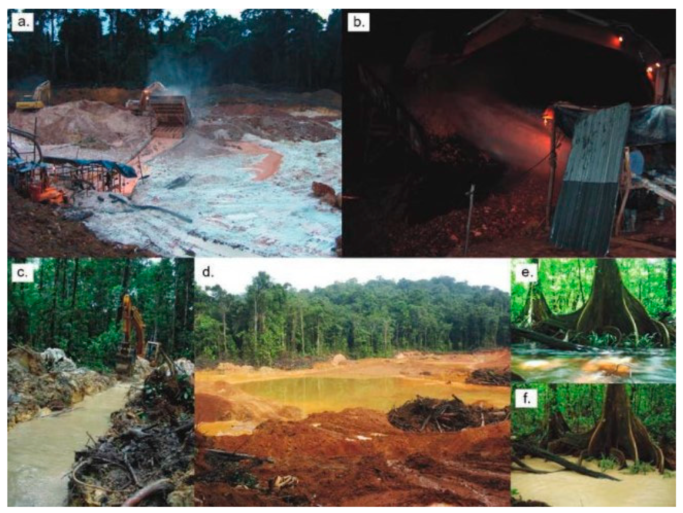
Figure 2.
Study area.
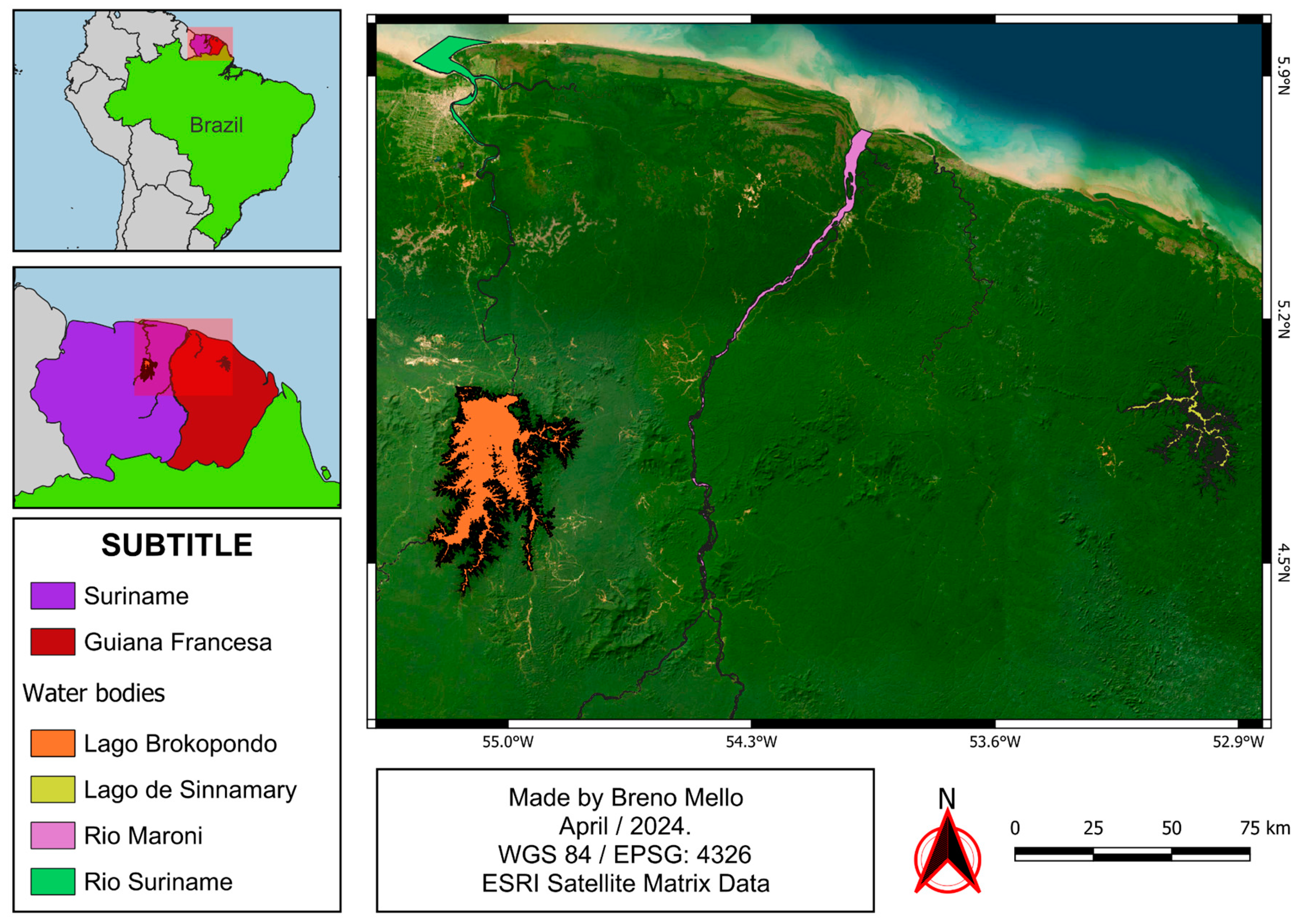
Figure 3.
Overall methodology.
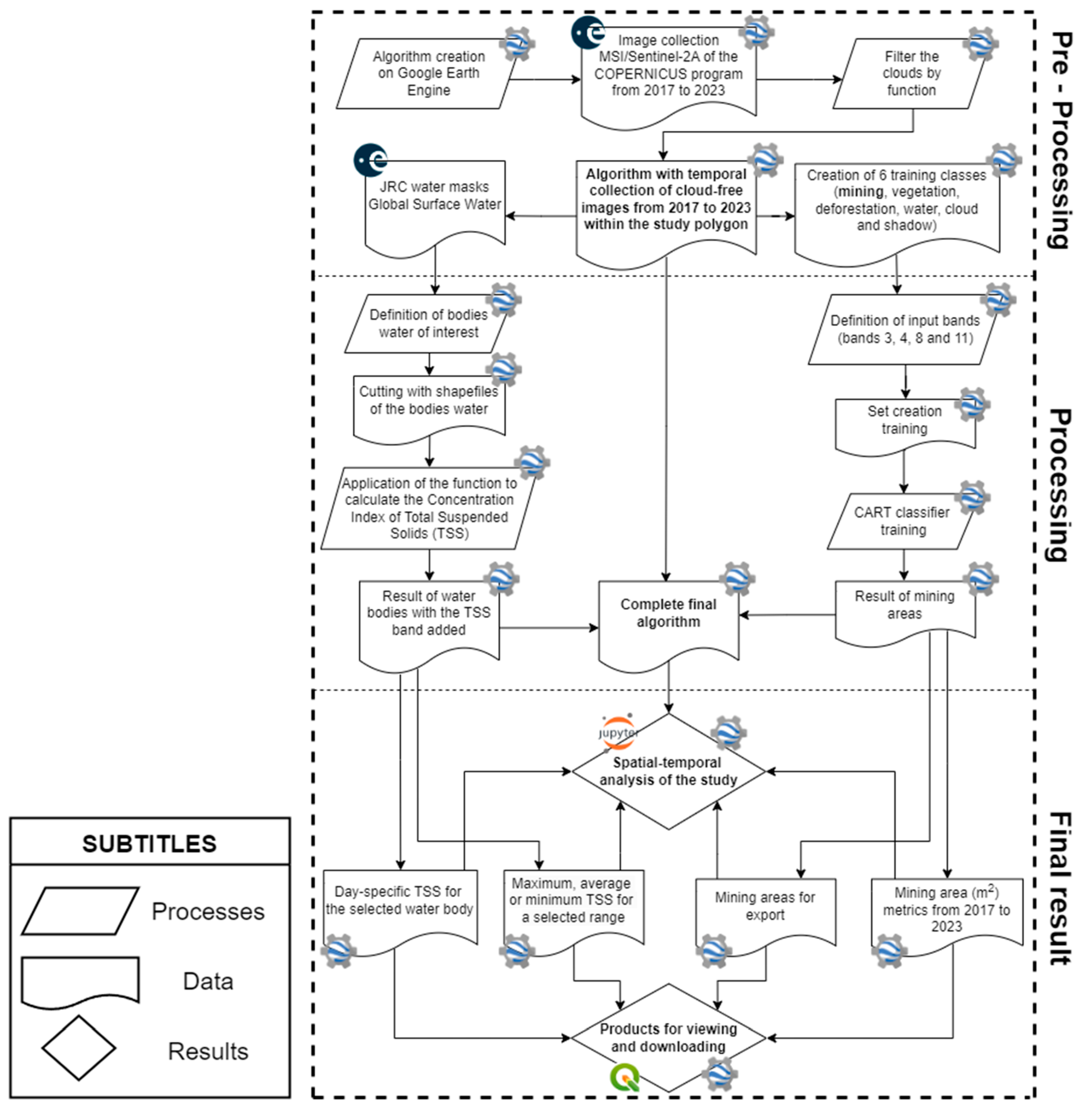
Figure 4.
Practical demonstration of the filter. From top left to bottom right: (a) Sentinel-2A image from June 8, 2023 over Lake Brokopondo, with the presence of clouds, (b) TSS classification over the original image, (c) classification after removing the clouds.
Figure 4.
Practical demonstration of the filter. From top left to bottom right: (a) Sentinel-2A image from June 8, 2023 over Lake Brokopondo, with the presence of clouds, (b) TSS classification over the original image, (c) classification after removing the clouds.
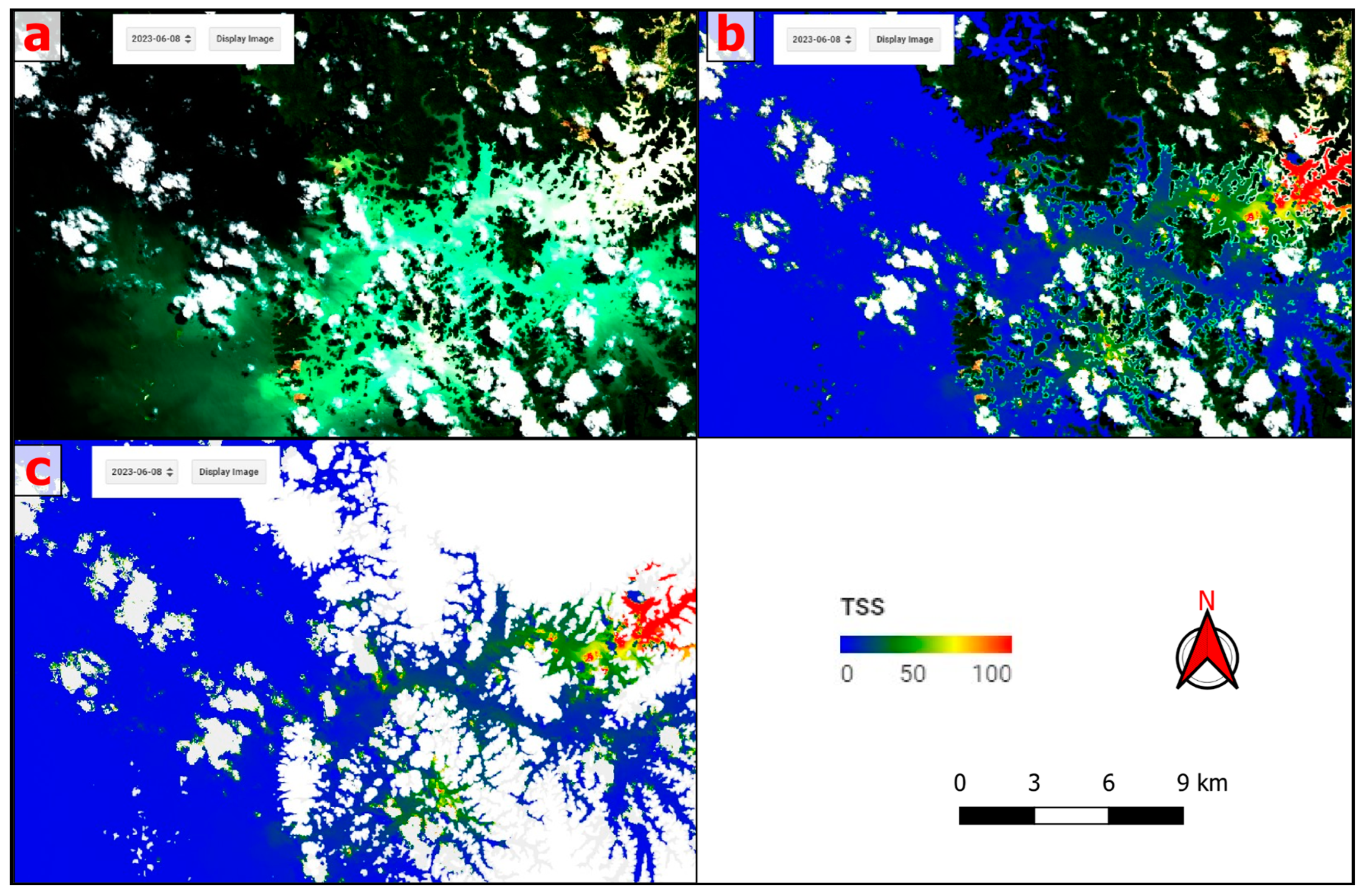
Figure 5.
Demonstration of some points used in training. From top left to bottom right: (a) Training of an extensive mining area, (b) training of a small mining area next to a water body, (c) classification of another mining area south of Lake Brokopondo.
Figure 5.
Demonstration of some points used in training. From top left to bottom right: (a) Training of an extensive mining area, (b) training of a small mining area next to a water body, (c) classification of another mining area south of Lake Brokopondo.
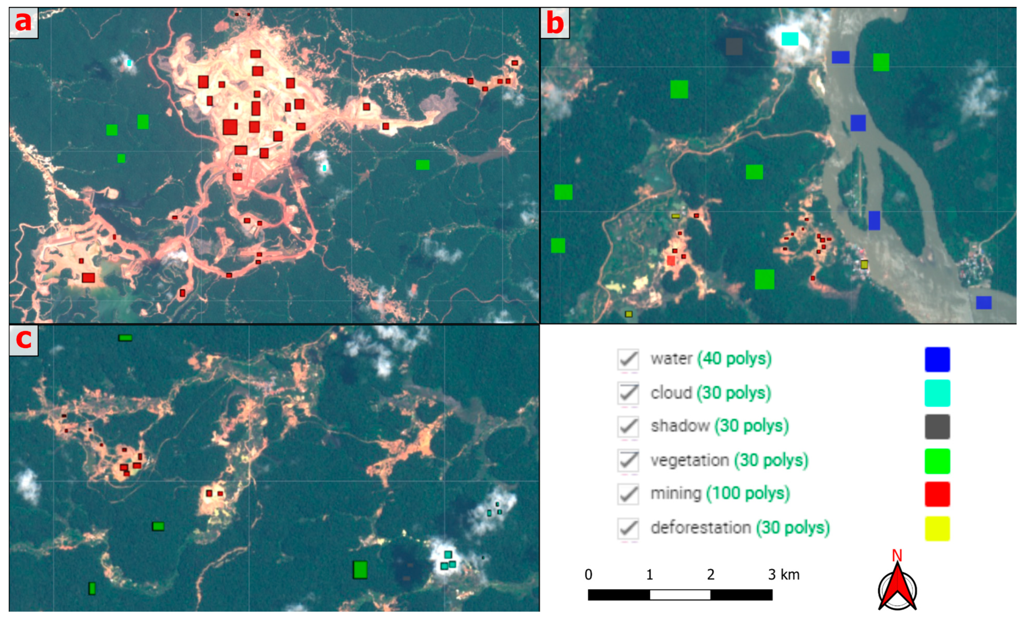
Figure 6.
CART classification. From top to bottom: (a) Sentinel-2A image (2023-01-09) of a mining area northeast of Lake Brokopondo, (b) result of CART classification with the 6 classes.
Figure 6.
CART classification. From top to bottom: (a) Sentinel-2A image (2023-01-09) of a mining area northeast of Lake Brokopondo, (b) result of CART classification with the 6 classes.
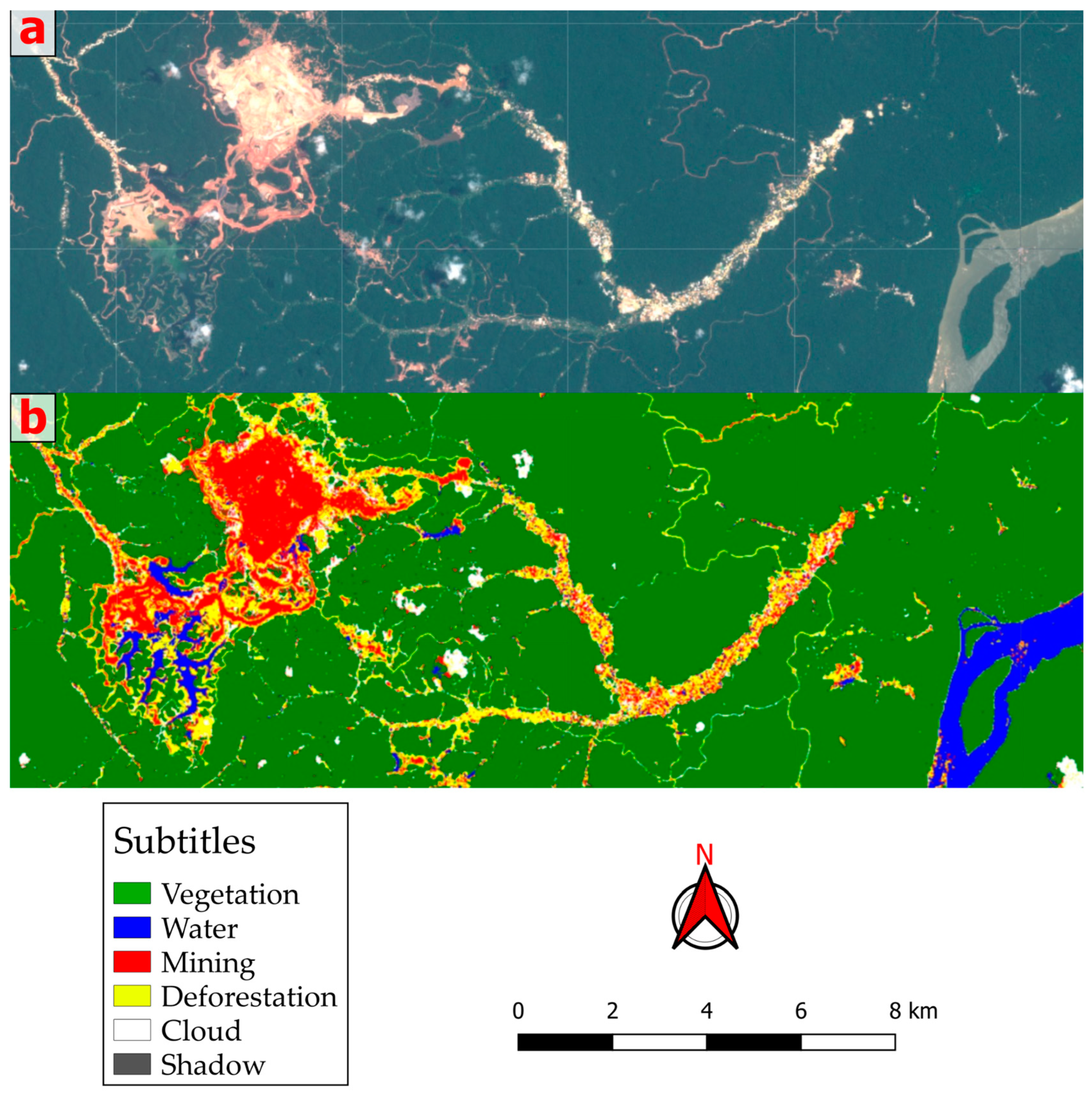
Figure 7.
Illustrative image of the TSS classification in the algorithm in Google Earth Engine. From left to right: (a) Sentinel-2 image from 2023-09-06 and (b) Sentinel-2 image from the same day with the TSS classification band (mg/L) added.
Figure 7.
Illustrative image of the TSS classification in the algorithm in Google Earth Engine. From left to right: (a) Sentinel-2 image from 2023-09-06 and (b) Sentinel-2 image from the same day with the TSS classification band (mg/L) added.
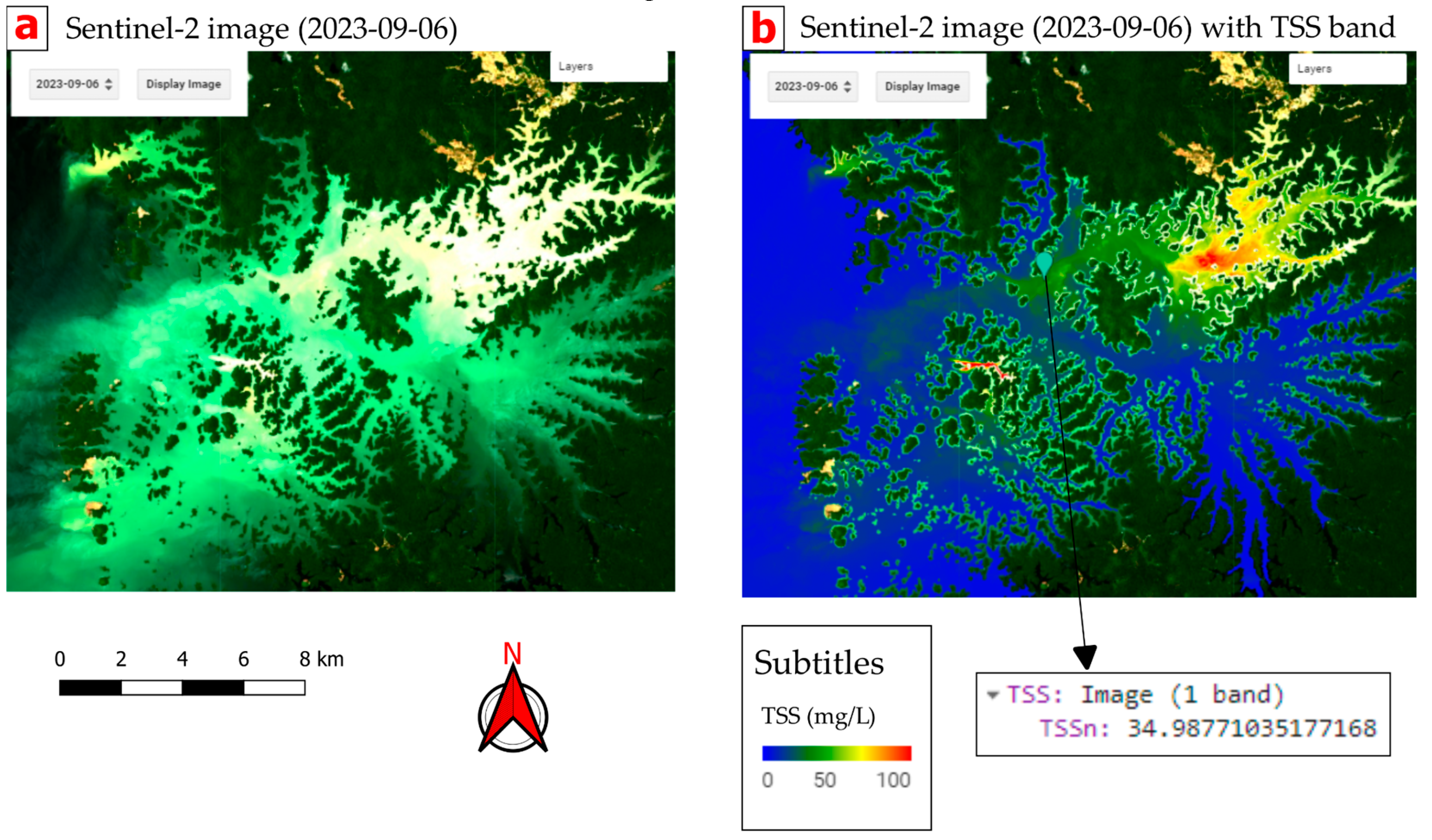
Figure 8.
Demonstration of the validation process. From top to bottom: (a) first mining point, (b) second mining point and (c) third mining point.
Figure 8.
Demonstration of the validation process. From top to bottom: (a) first mining point, (b) second mining point and (c) third mining point.
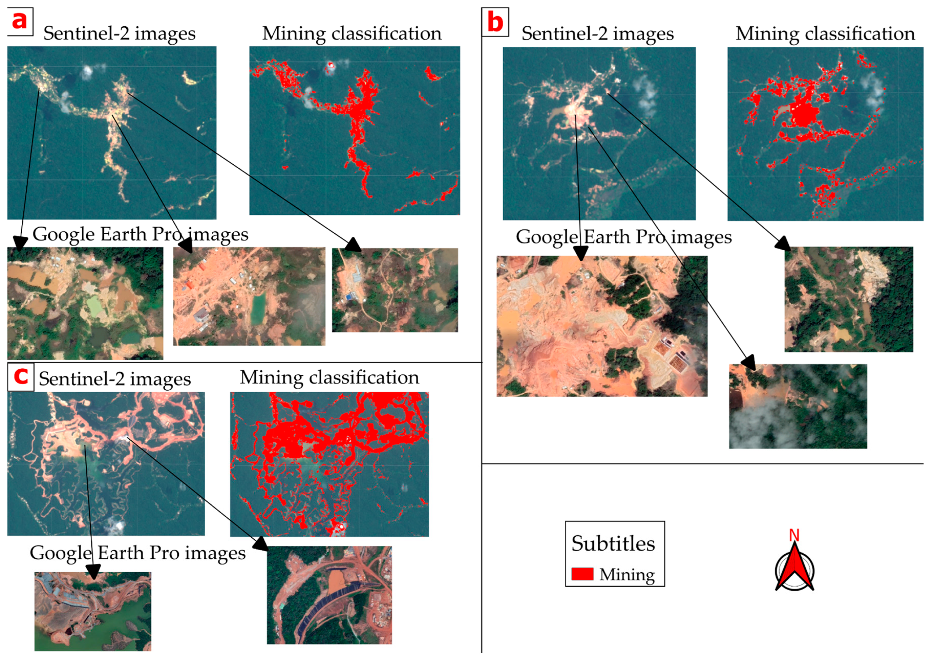
Figure 9.
Mapping of mining and associated structures. From left to right: (a) first mining point and (b) second mining point.
Figure 9.
Mapping of mining and associated structures. From left to right: (a) first mining point and (b) second mining point.
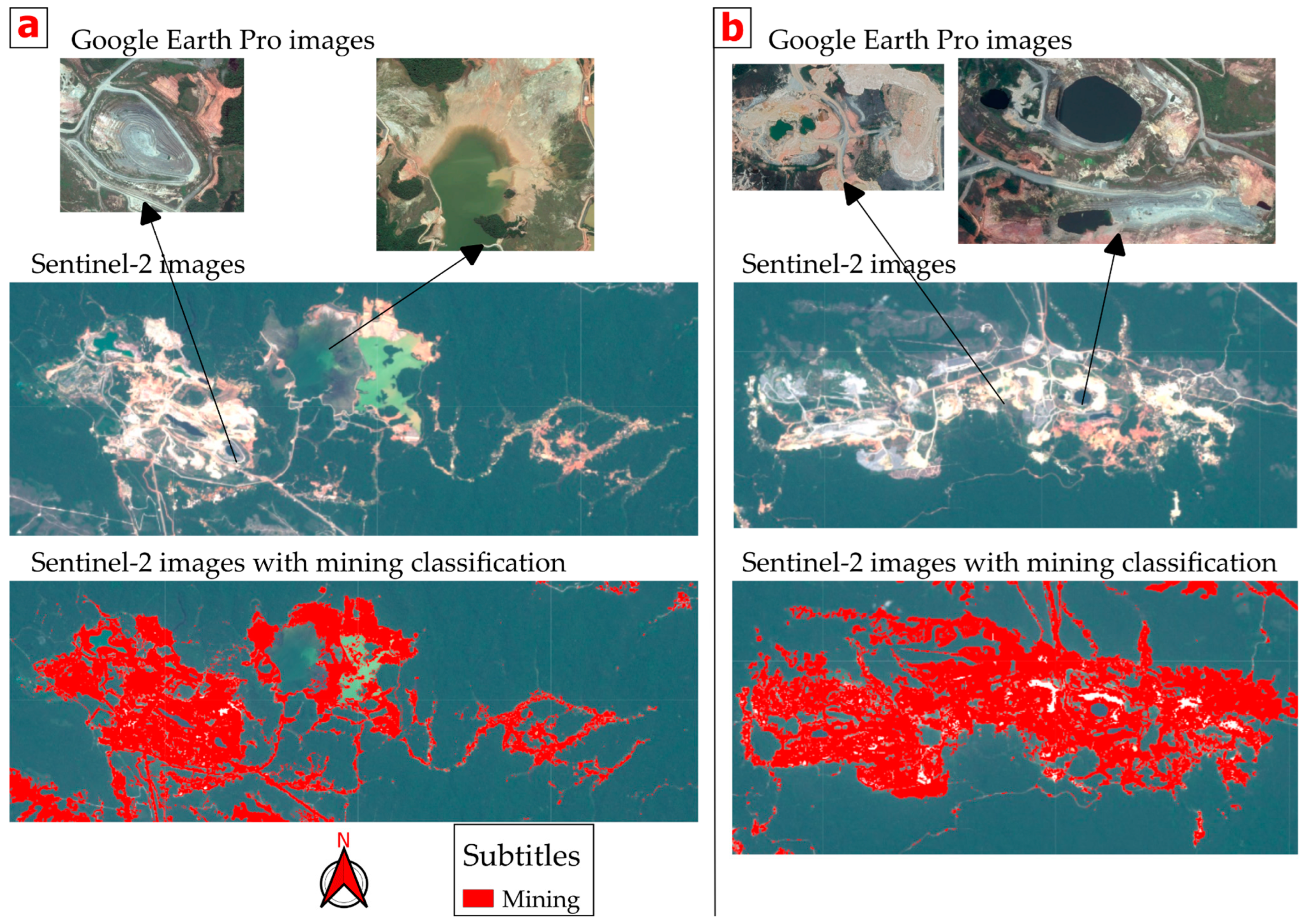
Figure 10.
Map of mining mapped in each year, from 2017 to 2023.
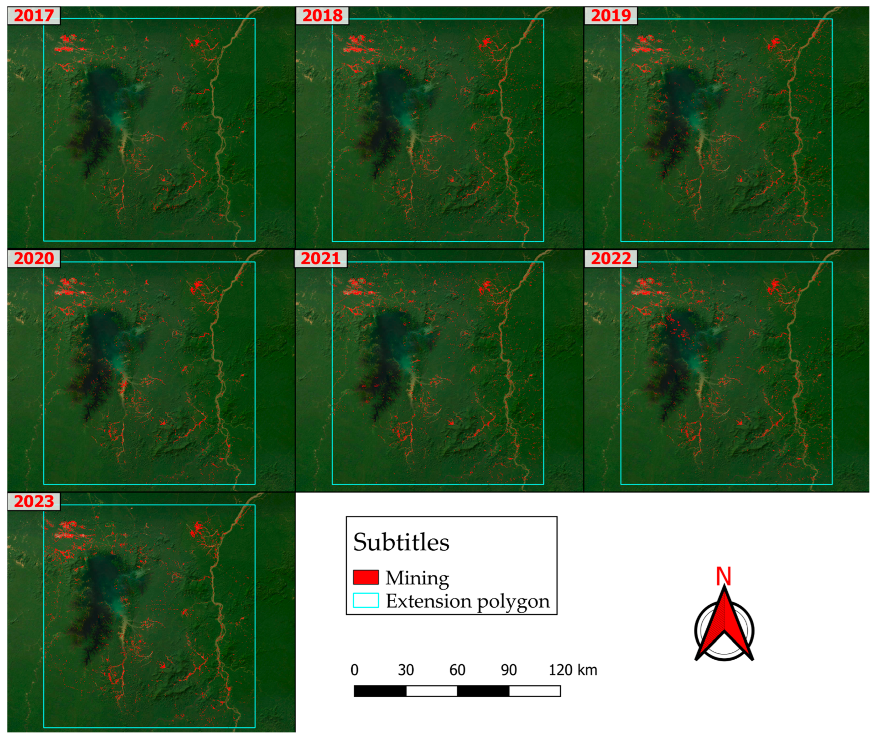
Figure 11.
Mining graph by year, from 2017 to 2023.
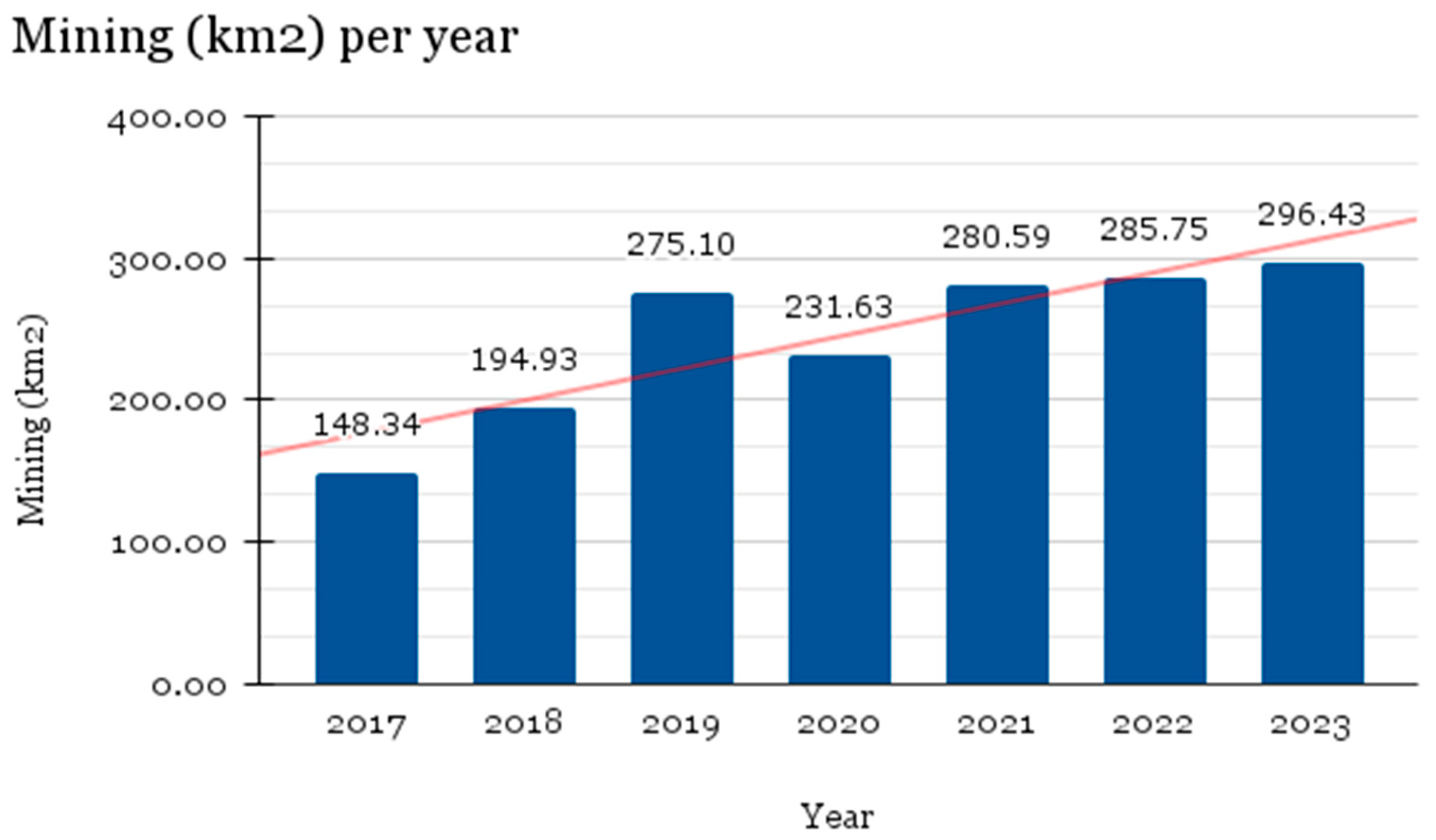
Figure 12.
Map with TSS graphs by year (2017 to 2023), water bodies have a band in which each pixel represents its average value over the years studied.
Figure 12.
Map with TSS graphs by year (2017 to 2023), water bodies have a band in which each pixel represents its average value over the years studied.
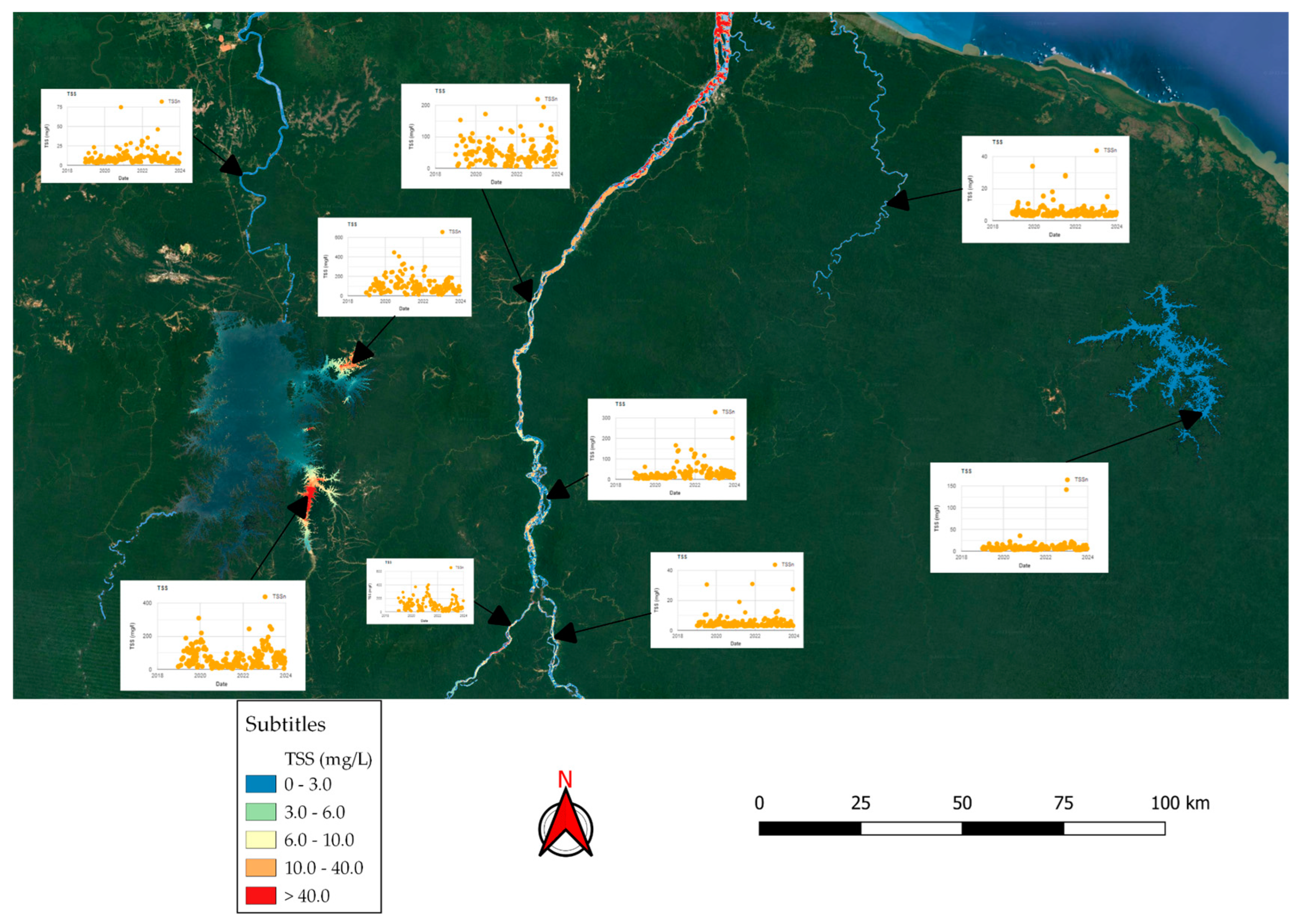
Figure 13.
Illustrative figure elucidating mining in two different cases increasing the TSS of the water. From left to right: (a) first mining point and (b) second mining point.
Figure 13.
Illustrative figure elucidating mining in two different cases increasing the TSS of the water. From left to right: (a) first mining point and (b) second mining point.
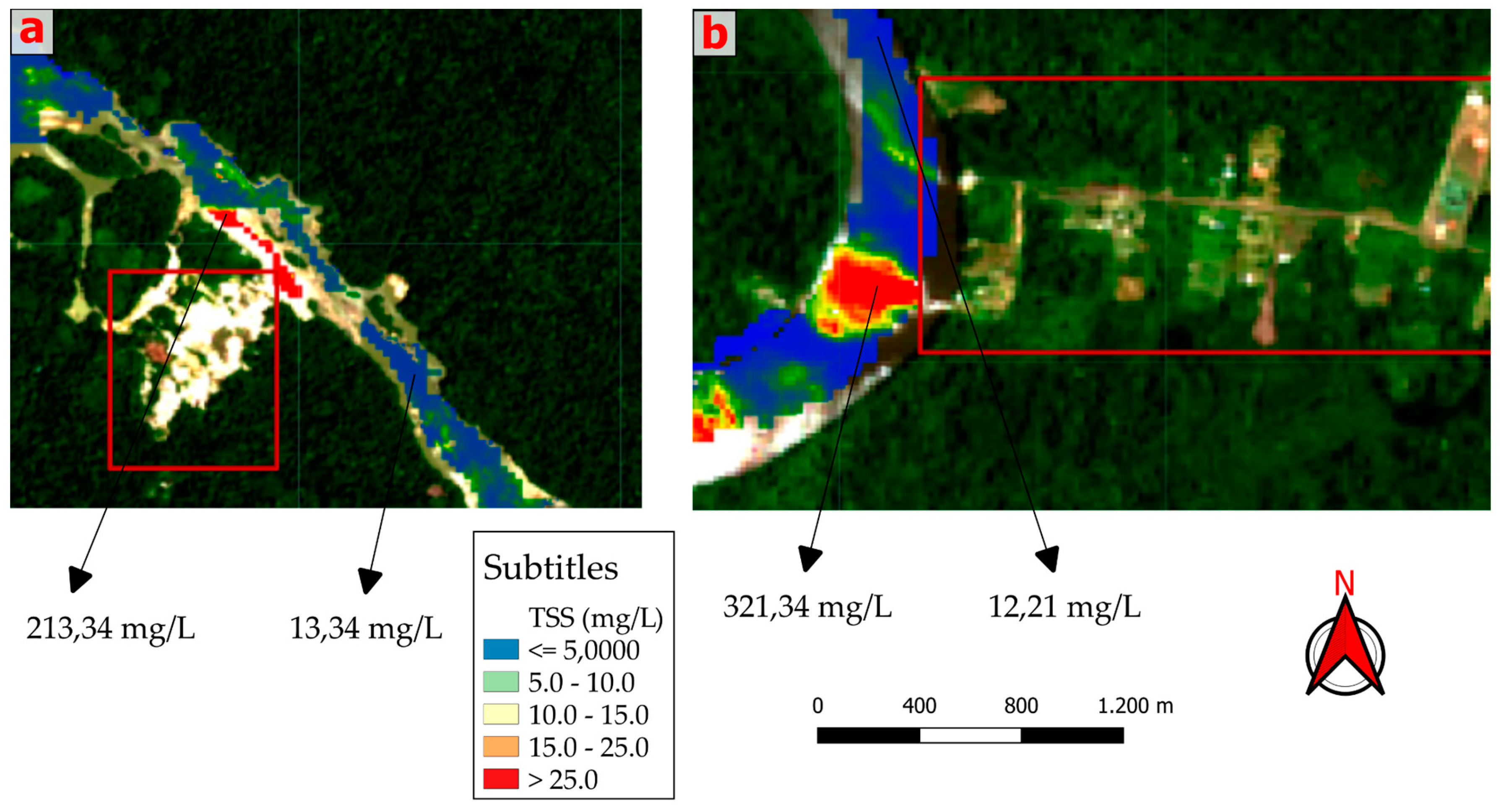
Figure 14.
Subtractive map between the years 2023 and 2017. From left to right from top to bottom: (a) TSS average for 2017, (b) TSS average for 2023 and (c) subtractive image between the two years.
Figure 14.
Subtractive map between the years 2023 and 2017. From left to right from top to bottom: (a) TSS average for 2017, (b) TSS average for 2023 and (c) subtractive image between the two years.
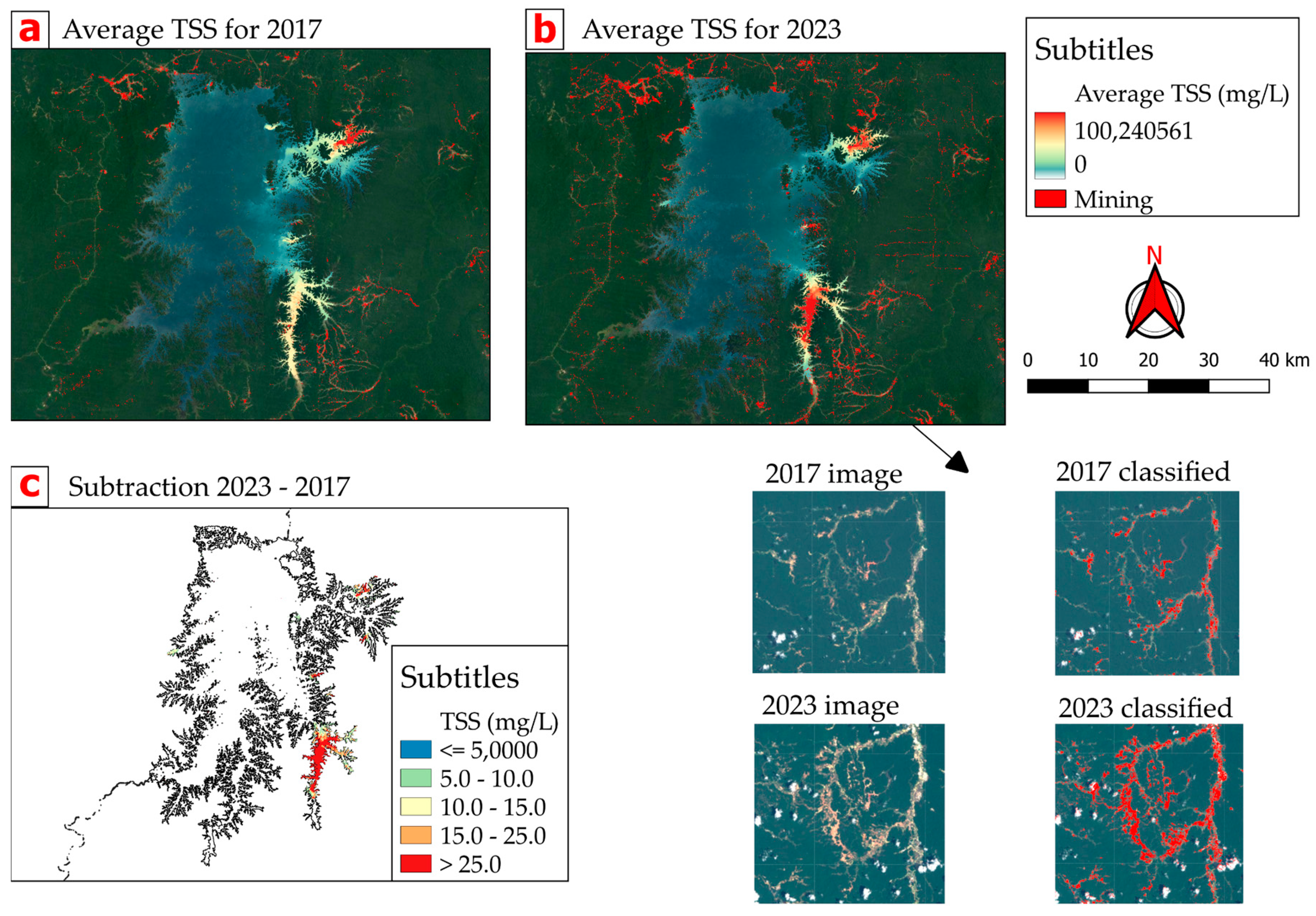

Table 1.
Sentinel-2A bands table.
| Band | Name | Spectral Range (nm) | Spatial Resolution (m) |
|---|---|---|---|
| Band 1 | Coastal aerosol | 443 | 60 |
| Band 2 | Blue | 490 | 10 |
| Band 3 | Green | 560 | 10 |
| Band 4 | Red | 665 | 10 |
| Band 5 | Red Edge 1 | 705 | 20 |
| Band 6 | Red Edge 2 | 740 | 20 |
| Band 7 | Red Edge 3 | 783 | 20 |
| Band 8 | NIR (Near Infrared) | 842 | 10 |
| Band 8A | Narrow NIR | 865 | 20 |
| Band 9 | Water vapor | 945 | 60 |
| Band 10 | SWIR - CIRRUS | 1375 | 60 |
| Band 11 | SWIR 1 | 1610 | 20 |
| Band 12 | SWIR 2 | 2190 | 20 |
Table 2.
Class training table.
| Training class | Number of samples |
|---|---|
| Mining | 100 |
| Water | 40 |
| Vegetation | 30 |
| Cloud | 30 |
| Shadow | 30 |
| Deforestation | 30 |
| Total | 260 |
Table 3.
Total area of mining.
| Year | 2017 | 2018 | 2019 | 2020 | 2021 | 2022 | 2023 |
|---|---|---|---|---|---|---|---|
| Mining (km2) | 148.344724 | 194.933177 | 275.098510 | 231.627975 | 280.586329 | 285.746225 | 296.431852 |
| Mining (m2) | 148344724 | 194933177 | 275098510 | 231627975 | 280586329 | 285746225 | 296431852 |
Table 4.
Table of metrics for water bodies.
| Water body | Average TSS (mg/l) | Standard Deviation (mg/l) |
|---|---|---|
| Maroni River | 45.69 | 17.75 |
| Suriname River | 12.72 | 8.52 |
| Brokopondo Lake | 34.91 | 21.71 |
| Sinnamary Lake | 14.52 | 5.68 |
Disclaimer/Publisher’s Note: The statements, opinions and data contained in all publications are solely those of the individual author(s) and contributor(s) and not of MDPI and/or the editor(s). MDPI and/or the editor(s) disclaim responsibility for any injury to people or property resulting from any ideas, methods, instructions or products referred to in the content. |
© 2024 by the authors. Licensee MDPI, Basel, Switzerland. This article is an open access article distributed under the terms and conditions of the Creative Commons Attribution (CC BY) license (http://creativecommons.org/licenses/by/4.0/).
Copyright: This open access article is published under a Creative Commons CC BY 4.0 license, which permit the free download, distribution, and reuse, provided that the author and preprint are cited in any reuse.


