Submitted:
11 July 2023
Posted:
13 July 2023
You are already at the latest version
Abstract
Electrical Resistivity Tomography (ERT) was conducted to delineate groundwater potential zones in villages located in the Galhareri district of the Galgaduud region, central Somalia. A total of four ERT profiles were examined using the gradient configuration, chosen for its practical advantages over other configurations. The study revealed that all profiles were situated within similar geological environments, characterized by comparable rock types. However, notable disparities were observed in lithological variations, particularly in the texture of rocks encountered at different locations and in the thicknesses of the encountered geo-electric layers. The two-dimensional inversion results derived from the electrical resistivity data unveiled the presence of four geo-electrical layers. The first layer was interpreted as sand dunes. The second layer exhibited relatively higher resistivity values, indicating the presence of compact limestone and sandstone. The resistivity of the third layer suggested the existence of a lower resistivity layer, interpreted as weathered limestone, while the fourth layer demonstrated very low apparent resistivity, interpreted as sandy clay with sandstone. The ERT models constructed for the survey area effectively delineated the aquifer zone, represented by layer 3, which likely consists of weathered limestone, sandy clay, and sandstone. The resistivity values obtained for the aquifer zone, specifically at depths ranging from 200 to 300 m, were relatively low, suggesting that the groundwater quality is brackish in nature
Keywords:
Aquifer
; electrical resistivity tomography
; groundwater
; Galgaduud region
; Somalia.
1. Introduction
Somalia is recognized as one of the regions in the Horn of Africa that is highly susceptible to drought, with irregular and short-duration rainfall events [1]. The Galmudug region, located in central Somalia, predominantly experiences an arid and semi-arid climate, rendering it particularly vulnerable to the risks of climate change-induced drought and water scarcity. The entire region has faced challenges associated with below-normal rainfall and limitations imposed by poor soil quality. Rainfall distribution follows a bi-modal pattern, characterized by isolated storms influenced by seasonal monsoon systems and shifts in monsoon winds. Central Somalia generally experiences two rainy seasons locally known as "Gu'" (April to June) and "Deyr" (October to November), alternating with two dry seasons referred to as "Jilaal" (December to March) and "Haggaa" (July to September). Over the past five years, temperatures in the region have ranged from 21°C to 40°C, with an average temperature of 33°C, contributing significantly to high rates of evapotranspiration. Consequently, the water supply situation in many parts of Somalia is critical, primarily due to the region's very low effective annual rainfall. As a result, groundwater development becomes a crucial water source in numerous areas. Despite various deep drilling projects undertaken in the Galgaduud region, the success rate of groundwater development and the drilling of productive wells has remained remarkably low, largely attributed to the lack of prior hydrogeological knowledge. Furthermore, studies have revealed poor groundwater quality in central Somalia, rendering it unsuitable for drinking purposes [2].
Geophysical surveys play a crucial role in the investigation of subsurface geologic phenomena and can provide valuable insights into surface geology. Within the realm of groundwater exploration, various geophysical techniques have been widely employed, including geo-electrical resistivity, electromagnetic (EM) profiling, seismic refraction, and geophysical borehole logging. Among these techniques, electrical resistivity methods have gained significant popularity in groundwater investigations [3,4,5,6,7]. Electrical resistivity techniques offer numerous advantages, such as their field-friendly nature, ability to provide subsurface information at depths ranging from a few meters to hundreds of meters, and the availability of software for 2D and 3D interpretation.
Moreover, the electrical resistivity method proves instrumental in addressing various hydrogeological challenges, including (1) monitoring industrial waste contamination and pollutants [8]), (2) determining the spatial extent of groundwater aquifers [9]), (3) estimating hydraulic parameters of aquifers [10,11] (4) monitoring aquifer recharge[12], and (5) characterizing seawater intrusions in coastal groundwater aquifers [13,14]. Two geophysical methods are commonly employed to study the electrical resistivity characteristics of groundwater aquifers. EM methods offer the capability to detect shallow and deep groundwater aquifers [15], but they require costly equipment and necessitate precautions to avoid cultural and industrial noise as well as power lines. On the other hand, electrical methods encompass a range of techniques and configurations (arrays), making them suitable for noisy environments, and are the most prevalent techniques employed in hydrogeological investigations.
From September 15 to 20, 2022, a 2D electrical resistivity tomography (ERT) survey was conducted in the Galhareri district of the Galgaduud region in central Somalia (Figure 1). The survey focused on three areas of interest, namely Xaji Iman, El-Jiqow, and Daba-Duleel villages. The primary objectives of the survey were (a) to explore the groundwater aquifer and its electrical characteristics, (b) to gain insights into the resistivity structure and distribution beneath the survey area, and (c) to determine the depth and thickness of the aquifer and saturated zone, with the aim of facilitating future well-drilling endeavors for groundwater extraction.
2. Geological Setting and Hydrogeology of the Survey Area
2.1. Geological Setting
The survey area is situated on the coastal plains of central Somalia, characterized by relatively flat terrain with elevations ranging from 200 to 350 m above sea level (Figure 1a). Numerous studies have been conducted to describe the geology of central Somalia, including works by [2,17] and Additionally, subsurface stratigraphy of the area has been derived from the drilling of four hydrocarbon exploration wells: El Bur-1, Marai Ascia-1, El Cabobe 1, and Meregh-1, with total depths (TDs) of 2621, 4115, 4428, and 4298 m, respectively (Figure 2).
The region exhibits a diverse range of sedimentary deposits spanning from the Cretaceous to Recent (Figure 1b). However, the predominant formations outcropping within the survey area consist of various continental Quaternary deposits, such as caliche and related rocks, secondary gypsum, gypsiferous clay, aeolian red sands, as well as Oligocene to Early Miocene deposits of the Mudug Succession, comprising gypsiferous sand, sandy clay, and limestones.
The oldest exposed sediments in the region belong to the Cretaceous Yesomma Formation. The Yesomma Formation predominantly comprises conglomerates, sandstones, sandy mudstones, and mudstones. Notably, the aquifer within the Yesomma Sandstone Formation is considered the most significant and primary water-bearing formation in the area.
The Eocene Auradu series, which follows the Yesomma Formation, consists of hard, massive limestone ranging in color from grey to white. The limestone often lacks bedding and is occasionally interbedded with thinly bedded layers of limestone, which may exhibit chalky and gypsiferous characteristics, along with calcareous shales. Another Eocene formation, the Taleh Formation, is widespread across central Somalia. This evaporitic formation, deposited under arid climatic conditions in a shallow sea environment, primarily consists of dense anhydrite beds, interspersed with layers of limestone and gypsum. Localized deposits of clay, sand, and gravel, transported by rivers in shallow lagoonal settings, can also be found within this sequence. Some areas exhibit lateral facies changes from gypsum and anhydrite to limestone, while changes from anhydrite to gypsiferous limestone and dense limestone are common and can be observed over relatively short distances.
During the upper Eocene and lower Oligocene, a shallow sea regression occurred, leading to the deposition of fossiliferous limestone and marls, forming the Karkar Formation. The Karkar Formation is characterized by bedded limestone, marly layers, and white marls. The limestone often exhibits karstification and possesses a well-developed system of caves. Thin layers of gypsum and occasional shale can also be encountered within certain sections of the formation.
Throughout the Oligocene to Miocene period, the sea receded from central Somalia, giving rise to continental and lagoonal environments across most of the region. Thick layers of Pleistocene to Recent sediments were subsequently deposited within plateau areas, between foothills and coastal strips, as well as in valley fills and deltaic deposits. These sediments are seasonally transported by ephemeral streams during the rainy season. The superficial deposits primarily consist of quartz grains, ranging from fine to coarse. The grains exhibit a well-rounded shape and sorting, although they may be mixed with clay in some instances.
2.2. Hydrogeology of the Survey Area
A comprehensive understanding of the hydrogeological conditions in the survey area, including groundwater flow patterns, electrical properties, and other hydrogeological characteristics, can be attained through a thorough knowledge of the stratigraphy and geological structures.
Surface water resources in the survey area are limited. There are no perennial rivers, except for small seasonal Wadis or streams that temporarily flow during the rainy seasons (Gu and Deyr seasons) for short durations. These watercourses are mostly ephemeral and originate from the Ogaden plateau, flowing towards the east. However, surface water availability is practically nonexistent as the rainfall in the catchment areas is largely lost through evaporation and infiltration.
Groundwater serves as the primary water source in the survey area, with two main types of groundwater resources: shallow wells and deep boreholes. The shallow aquifers, accessed through hand-dug wells, are located within a broad depression covered by gypsiferous soils, gypsum, and limestone, often following the ancestral drainage systems. The depths and water table levels of shallow aquifers vary across different locations, with water depths generally exceeding 15 m and water table depths ranging between 4 to 6 m.
Based on borehole lithological logs in the survey area, groundwater aquifers are encountered within sedimentary terrains, consisting of limestone, sandstone, porous white medium limestone, and white marl. Drilled boreholes suggest that aquifers generally occur at depths ranging from 110 m to over 200 m below the ground level. The aquifer zones within the shallow marine limestone formations are semi-confined to confined, with reported yields ranging from 12 m3/h to 22 m3/h in boreholes penetrating these formations. Available data on electrical conductivity (EC) values for boreholes ranging from 180 to 350 m in depth indicate values between 3,000 μS/cm and 8,000 μS/cm, with total dissolved solids (TDS) ranging from 2,000 to 5,000 ppm. These results suggest that water quality in the survey area is poor, primarily due to higher salinity resulting from the chemical composition of the surrounding rocks.
3. Methodology and Data
In September 2022, four Electrical Resistivity Tomography (ERT) profiles were acquired to investigate the hydro-stratigraphy of the survey area. Profiles 1 and 2 were obtained in Haji Iman and El-Jiqow villages, while Profiles 3 and 4 were acquired in Dab-Duleel village. ERT was employed to generate a pseudosection of the subsurface, allowing for deductions regarding aquifer zones and their thicknesses [19]. The ABEM Terrameter LS2 instrument was utilized to map and determine the resistivities of subsurface lithologies, assess their potential as aquifers, and estimate groundwater quality. The electrode spacing was consistently maintained at 20 m throughout the survey, with variations in length and orientation. The gradient protocol, chosen for its sensitivity to vertical and lateral geological structures as well as its high horizontal and vertical resolutions, was applied across all survey sites. A thorough electrode test was conducted to verify the performance and ensure good ground contact for each electrode. For electrodes with poor contact, a salt solution was applied to enhance their performance. The measurement sequence was completed within a timeframe of 30 to 40 minutes. During data acquisition, the four basic electrodes could be either active or passive, as they were selected simultaneously. To investigate deeper depths, the electrode spacing was increased.
In the processing of the ERT data, the initial step involved the removal of noisy data points from each ERT line. These noisy values, characterized by negative and excessively high resistivity, were attributed to high contact resistance at specific electrode locations. Despite the use of salty water to reduce contact resistance, some electrodes still exhibited noisy data due to the challenging surface geology consisting of dry gravel and sand materials. After editing each ERT dataset to eliminate the noisy values, the apparent resistivity values were inverted to obtain the true resistivity values along the survey lines.
The resistivity values were calculated from the field data and modeled against electrode position using RES2DInv software, resulting in a plot of apparent resistivity variation with depth. The RES2DInv software employs a finite-difference modeling subroutine to calculate the apparent resistivity values, while a non-linear smoothness-constrained least-squares optimization technique is used to calculate the resistivity of the model blocks [20,21]). The inversion routine implemented by RES2DInv is based on the smoothness-constrained least-squares method [20,21]. One advantage of this method is its ability to adjust the damping factor and roughness filters to accommodate different types of data. Beginning with an initial model, typically a homogeneous earth model, the program calculates the change in (Δqk) that minimizes the difference between the calculated and measured apparent resistivity values (g). It adjusts the resistivity of the model blocks while adhering to the imposed smoothness constraints. The root-mean-squared (RMS) error measures the difference between the calculated and measured values. However, the model with the lowest RMS error may exhibit large and unrealistic variations in the resistivity values, and may not always be the most geologically plausible model. As a general practice, it is prudent to select the model at the iteration where the RMS error stabilizes and no longer changes significantly, typically occurring between the 3rd and 6th iterations. The resulting output model provides a pseudosection with a specific number of beds exhibiting different degrees of weathering and corresponding resistivity and thickness values [22].
3. Results and Discussion
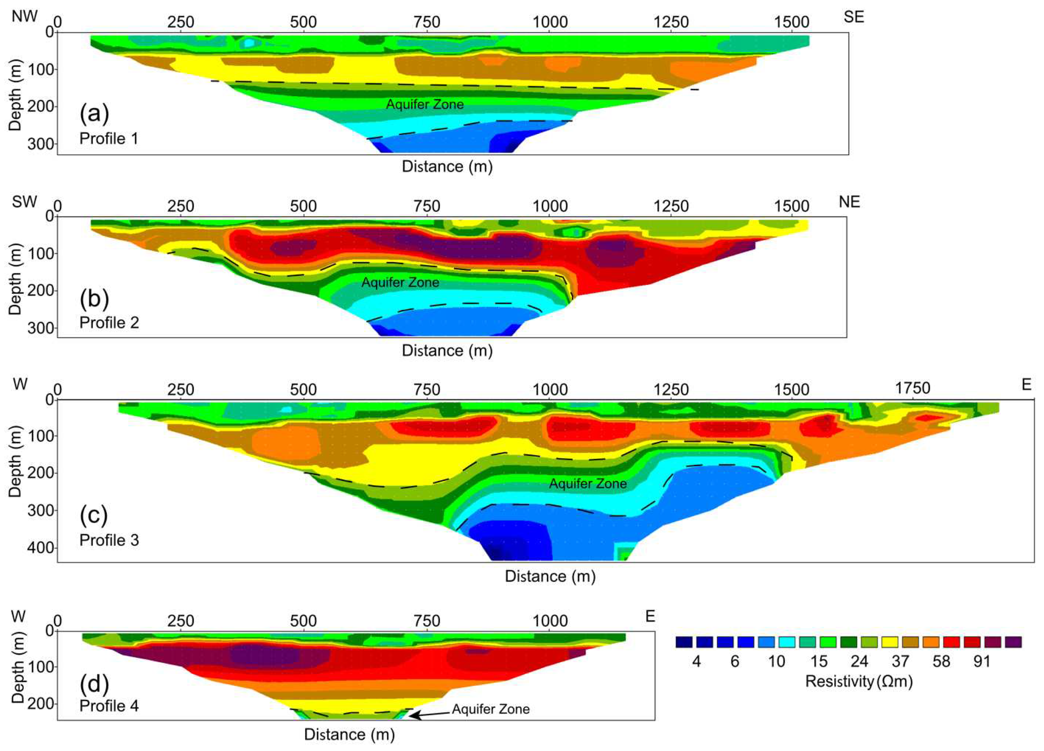
The results obtained from the inversion of the Electrical Resistivity Tomography (ERT) data provide valuable and detailed insights into the hydro-stratigraphic properties of the aquifer system within the surveyed area (see Figure 3). The inverted ERT sections reveal significant lateral and vertical variations in true resistivity, unveiling the presence of three distinct layers with unique characteristics.
The ERT results consistently demonstrate the existence of four geo-electrical layers throughout the survey area. The resistivity values observed in the ERT profiles exhibit a considerable range, spanning from 0.5 to 105 Ωm, indicating a wide variability in subsurface lithology. The depth penetration achieved by the ERT measurements extends to approximately 282 to 435 m below the ground surface, offering valuable insights into the deeper layers of the subsurface (see Figure 3).
The analysis of the ERT data enabled the identification and characterization of different geo-electrical layers, each exhibiting its own unique resistivity range and thickness. Through a comprehensive interpretation process, informed by local geological knowledge and the integration of available drilling logs from the survey area, the individual sections of the resistivity model were examined and correlated with the underlying geological formations.
The first layer observed in the resistivity model, characterized by resistivity values ranging from 15 to 20 Ωm and a thickness of approximately 30 to 40 m, can be confidently interpreted as the sand dune layer. This layer represents the near-surface deposits consisting of loose, unconsolidated sand, and it plays a crucial role in controlling surface water infiltration and recharge processes.
The second layer, distinguished by relatively higher resistivity values ranging from 60 to 100 Ωm, points to the presence of compact limestone and sandstone formations. This layer is characterized by its significant thickness variations, ranging from 30 to 50 m in Profiles 1 to 3, and exhibiting a remarkable thickness extension of up to 200 m in Profile 4 (see Figure 3). The variations in lithology and thickness within this layer suggest the presence of geological structures and sedimentary facies changes that contribute to the heterogeneity of the aquifer system.
The resistivity values of the third layer indicate the presence of a lower resistivity zone, typically ranging from 10 to 20 Ωm. This layer is interpreted as weathered limestone, suggesting a zone of altered and fractured rock material that has undergone chemical weathering processes over time. The weathered limestone layer often exhibits enhanced porosity and permeability, which can significantly influence groundwater flow and storage characteristics.
Lastly, the fourth layer, displaying very low apparent resistivity values below 10 Ωm, is interpreted as sandy clay interbedded with sandstone. This layer represents fine-grained sediments with limited hydraulic conductivity, potentially acting as an aquitard or confining layer that impedes vertical groundwater movement between the upper aquifer zones and the deeper geological formations.
The comprehensive analysis of the ERT models and geological information reveals crucial information about the aquifer system in the survey area. The total depth captured by the ERT sections extends approximately from 220 to 420 m, providing valuable insights into the deeper geological formations and their hydrogeological properties. Notably, the ERT models have successfully delineated an aquifer zone with a thickness ranging from approximately 100 to 130 m and a top depth varying from 150 to 200 m (see Figure 3). This aquifer zone consists of weathered limestone, sandy clay, and sandstone, suggesting the presence of potential groundwater resources. However, it is important to note that the resistivity values observed in the aquifer zone are relatively low, implying the presence of brackish water with higher salinity levels. The geological composition of the aquifer materials, such as the presence of weather
4. Conclusions
This study utilized Electrical Resistivity Tomography (ERT) to assess groundwater potential zones in villages located in the Galhareri district of the Galgaduud region, central Somalia. The investigation involved the examination of four ERT profiles using the gradient configuration, which offered practical advantages for this study. The geological environments in all profiles were found to be similar, characterized by comparable rock types. However, variations in lithology, particularly in rock texture and layer thickness, were observed across different locations.
The two-dimensional inversion of the electrical resistivity data revealed the presence of four distinct geo-electrical layers. The first layer was identified as sand dunes, while the second layer exhibited higher resistivity values indicative of compact limestone and sandstone. The third layer displayed lower resistivity, suggesting the presence of weathered limestone. Lastly, the fourth layer exhibited very low apparent resistivity, indicating sandy clay with sandstone.
The constructed ERT models effectively delineated the aquifer zone, represented by layer 3, which is likely composed of weathered limestone, sandy clay, and sandstone. The resistivity values obtained within this aquifer zone, particularly at depths ranging from 200 to 300 m, were relatively low, indicating a brackish nature of the groundwater.
These findings provide valuable insights into the hydrogeological characteristics of the study area. It is evident that the groundwater potential in the surveyed villages is influenced by the geological composition and layer variations. The delineation of the aquifer zone and the determination of its properties through ERT profiling contribute to a better understanding of the groundwater resources in the region.
Based on the results, it can be concluded that the study area exhibits a moderate to poor groundwater potential. The aquifer is located at depths exceeding 200 m below the ground level and is characterized by brackish water quality. This information is crucial for local water resource management and can aid in the development of appropriate strategies for sustainable groundwater utilization in the Galhareri district of the Galgaduud region, central Somalia. Further investigations and monitoring are recommended to enhance our understanding of the aquifer dynamics and to guide future water resource planning and management efforts in the area.
Supplementary Materials
The following supporting information can be downloaded at the website of this paper posted on Preprints.org.
Funding
The article was funded by Hormuud University
Data Availability Statement
Data are contained within the article.
Acknowledgments
The authors would like to thank all of their colleagues who helped with this research. We are grateful to the local community and elders in Galhareri for their generosity and support of us during this difficult work. We thank Hormuud University for supporting this study by providing equipment and logistics.
Conflicts of Interest
The authors declare no conflict of interest.
References
- FAO-SWALIM (2012). Hydrogeological Survey and Assessment of Seletced Areas in Somaliland and Puntland. Technical Report No. W-20, FAO-SWALIM (GCP/SOM/049/EC) Project, Nairobi, Kenya.
- Faillace, C. , Faillace E.R., 1986: Water quality data book of Somalia. Hydrogeology and water quality of south central Somalia, Vol 1.
- El-Qady G, Ushijima K (2001) Inversion of DC resistivity data using neural networks. Geophys Prospect 49:417–430El-Qady G, Ushijima K (2001) Inversion of DC resistivity data using neural networks. Geophys Prospect 49:417–430.
- Ghosh DI (1971). The application of linear filter theory to the direct interpretation of geoelectrical resistivity sounding measurements. Geophys Prospect 19:192–217.
- Griffith DH, Rooney WJ (1993) Two-dimensional resistivity imaging and modeling in areas of complex geology. J Appl Geophys 29:211–226.
- Loke MH, Dahlin T, Rucker DF (2014) Recent developments of the direct-current geoelectrical imaging method. Geophysics 95:135–156.
- Telford WM, Geldart LP, Sheriff RE (1990) Applied Geophysics, 2nd edn. Cambridge University Press, Cambridge.
- Rockhold ML, Robinson JL, Parajuli K, Song X, Zhang ZF, Johnson TC (2020) Groundwater characterization and monitoring at a complex industrial waste site using electrical resistivity imaging. Hydrogeol J 28:2115–2127. [CrossRef]
- Greggio N, Giambastiani BMS, Balugani E, Amaini C, Antonellini M (2018) High-resolution electrical resistivity tomography (ERT) to characterize the spatial extension of freshwater lenses in a salinized coastal aquifer. Water 10(8):1067. [CrossRef]
- De Clercq T, Jardani A, Fischer P, Thanberger L, Vu TM, Pitaval D, Côme J-M, Begassat P (2020) The use of electrical resistivity tomograms as a parameterization for the hydraulic characterization of a contaminated aquifer. J Hydrol 587:124986.
- Kazakis N, Vargemezis G, Voudouris KS (2016) Estimation of hydraulic parameters in a complex porous aquifer system using geoelectrical methods. Sci Total Environ 550:742–750. [CrossRef]
- Sendros A, Himi M, Lovera R, Rivero L, Garcia-Artigas R, Urruela A, Casas A (2020) Electrical resistivity tomography monitoring of two managed aquifer recharge ponds in the alluvial aquifer of the Llobregat river (Barcelona, Spain). Near Surface Geophys 18(4):353–368. [CrossRef]
- Galazoulas EC, Mertzanides YC, Petalas CP, Kargiotis EK (2015) Large scale electrical resistivity tomography survey correlated to hydrogeological data for mapping groundwater salinization: a case study from a multilayered Coastal Aquifer in Rhodope, Northeastern Greece. Environ Process 2:19–35. [CrossRef]
- Niculescu BM, Andrei G (2021) Application of electrical resistivity tomography for imaging seawater intrusion in a coastal aquifer. Acta Geophys. [CrossRef]
- McNeill, J.D. (1990) Use of Electromagnetic Methods for Groundwater Studies.
- Abbate, E. , Sagri M. & Sassi F.P. (with the collaboration of Aden I.H., Arush M.A., Yusuf O.S.)., 1994: The geological map of Somalia 1:1.500.000. University of Florence, SELCA, Florence.
- Muthusi F., M. , Mugo M. W., and Gadain H. M. (2009), Water Sources Inventory for Central – South Somalia. Technical Report No W-17, FAO-SWALIM (GCP/SOM/048/EC) Project, Nairobi, Kenya.
- Bosellini, A. (1992). The Continental Margins of Somalia: Structural Evolution and Sequence Stratigraphy: Chapter 11: African and Mediterranean Margins.
- Loke, M. (2001a). Tutorial: 2-D and 3-D electrical imaging surveys. Penang, Malaysia, University of Sains Malaysia. Unpublished course notes, http://www. geoelectric. com.
- DeGroot-Hedlin and Constable, 1990. The inversion routine implemented by RES2DInv is based on the smoothness-constrained least-squares method (deGroot-Hedlin and Constable, 1990; Sasaki, 1992; Loke et al., 2003).
- Loke, M.H. , Acworth, I. and Dahlin, T., 2003. A comparison of smooth and blocky inversion methods in 2D electrical imaging surveys. Exploration Geophysics, 34, 182–187.
- Loke, M. (2010). Fast computation of optimized electrode arrays for 2D resistivity surveys. [CrossRef]
Figure 1.
(a) and (b) Topographic and Geological maps of the survey area. The locations of hydrocarbon exploration wells El Bur-1, Marai Ascia-1, El Cabobe-1, and Meregh-1) are also shown. The insert map shown in the figure (a) displays the geographic map of Somalia. The geology map is modified from [16].

Figure 2.
Well correlation of hydrocarbon exploration wells (El Bur-1, Marai Ascia-1, El Cabobe 1, and Meregh-1) illustrating stratigraphy of the survey area. Refer Figure 1 for the location of the profile. The figure is modified from [18].
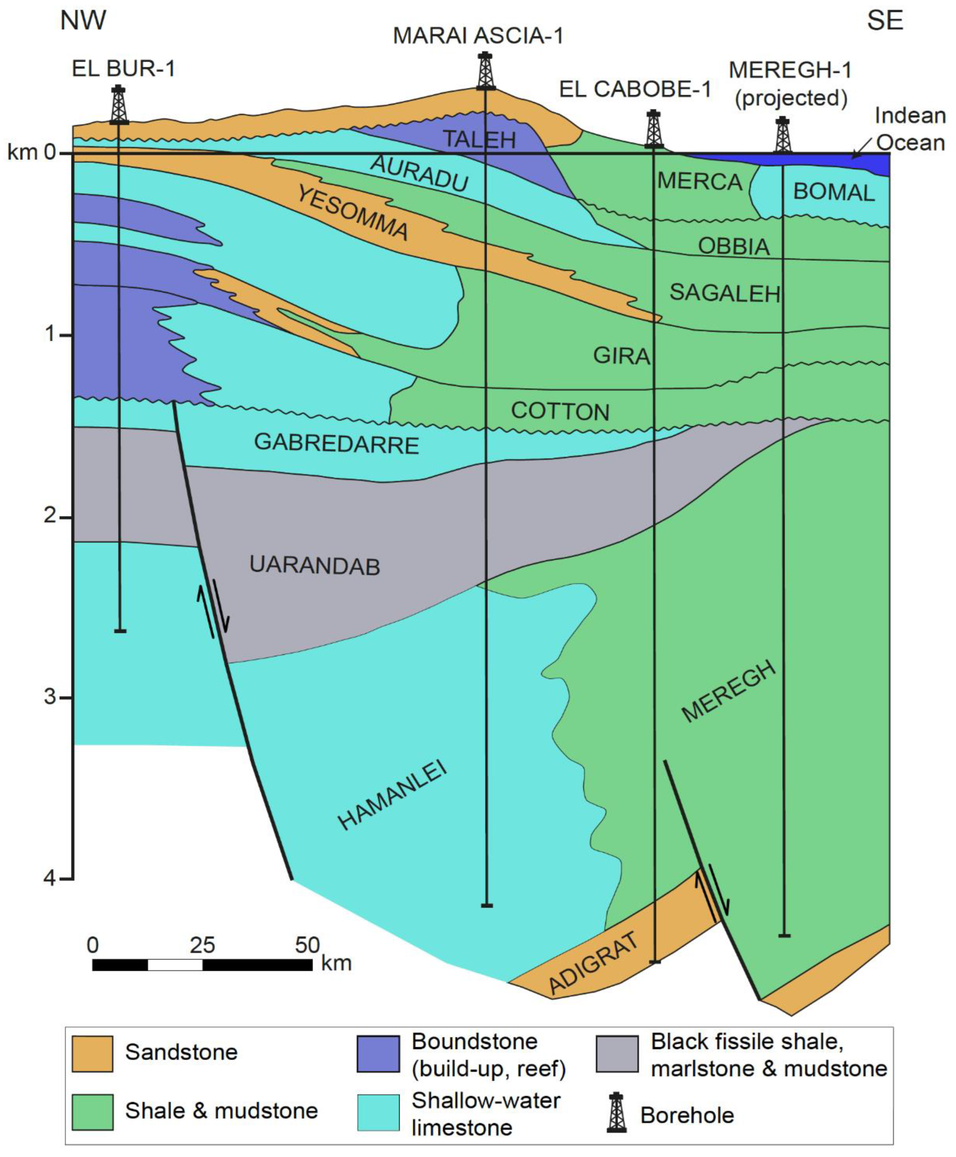
Figure 3.
ERT inverted sections of resistivity lines showing the interpretation of hydro-stratigraphic layers on the basis of well data and surface geology of the area.
Figure 3.
ERT inverted sections of resistivity lines showing the interpretation of hydro-stratigraphic layers on the basis of well data and surface geology of the area.
Disclaimer/Publisher’s Note: The statements, opinions and data contained in all publications are solely those of the individual author(s) and contributor(s) and not of MDPI and/or the editor(s). MDPI and/or the editor(s) disclaim responsibility for any injury to people or property resulting from any ideas, methods, instructions or products referred to in the content. |
© 2023 by the authors. Licensee MDPI, Basel, Switzerland. This article is an open access article distributed under the terms and conditions of the Creative Commons Attribution (CC BY) license (http://creativecommons.org/licenses/by/4.0/).
Copyright: This open access article is published under a Creative Commons CC BY 4.0 license, which permit the free download, distribution, and reuse, provided that the author and preprint are cited in any reuse.


